Walk #906: West Highland Way: East Drumquhassle to Inversnaid
 |
 |
|
General Data
| Date Walked | 01/07/2011 |
| County | Strathclyde, Central Scotland |
| Start Location | East Drumquhassle |
| End Location | Inversnaid |
| Start time | 07.07 |
| End time | 19.02 |
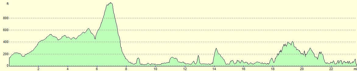
| Distance | 23.9 miles |
| Description | This was a very long walk, following the West Highland Way past Conic Hill and along the eastern shore of Loch Lomond. |
| Pack | Today I carried my Macpac Glissade rucksack containing my North Face Westwind tent, spare clothes, waterproofs, water, and enough food to last three days. In total it weighed about thirty-five pounds. |
| Condition | I feel very tired after this walk, but have no significant problems. |
| Weather | Today's weather was mostly bright and sunny, with the merest hint of a breeze to help me cool down. |
| OS map | Landranger number 57 (Stirling & The Trossachs) and Landranger number 56 (Loch Lomond & Inveraray) |
 |
 |
|
Map of the walk
Maps courtesy of Google Maps. Route for indicative purposes only, and may have been plotted after the walk. Please let me have comments on what you think of this new format. For a detailed table of timings for this walk, please see the table file.
 |
 |
|
Notes
I awoke before six this morning and could see little reason to prevaricate. I scoffed down a large pack of nuts and raisins and disassembled my camp. No-one was stirring and so I set off along the trail without having said good morning to anyone. An initial gentle climb proved surprisingly hard on fresh legs and it was a relief when I reached the summit. A Roman Fort is marked on the map beside the road but there was no sign of it on the ground when I glanced over the hedge. However the top of the hill did grant the first glimpses of Loch Lomond and Conic Hill, which I would soon be climbing.
The road descended past a large disused sand quarry on the left. Shortly after a left-hand bend a bridge over a stream was reached; here the trail left the road and descended down steps into a field. A short climb followed to reach the A811 immediately to the east of Drymen. A footpath behind a hedge provided a safe way of avoiding the road until a pavement began.
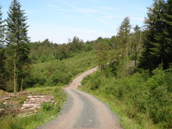
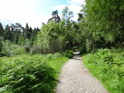
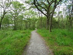
What followed was a long walk through Garadhban Forest with gentle ascents and descents. There was not much to commend this stretch of trail aside from a young deer that bounded across the track in front of me before stopping in the scrub beyond. I soon came across my first walker of the day; a young lad carrying a heavy pack; he must have camped somewhere in the forest overnight. Swarms of small flies were assaulting me as I walked, buzzing around my head and appearing to take great joy in avoiding my feebly-aimed swats at them.
It was a relief when I reached the junction of the tracks that marked the point where the trail splits. An easy route heads down to Milton of Buchanan and then along the road to Balmaha, whilst a harder route left the forest to climb up Conic Hill. Although it was tempting to take the easier route, I instead headed along the path that led out of the trees.
As I left the trees I met a man who was obviously out for a walk and we stopped for a chat. He was the first walker I had met on the West Highland Way who was not walking the trail, instead doing another walk in the surrounding hills. It felt good to chat, but all too soon I was striding uphill across the heathland. The path climbed for a while before descending to cross the Burn of Mar, all the while with the steep ascent of Conic Hill staring me in the face. This started well; I paused for breath a couple of times on the ascent, including one to stop to chat to some other walkers who were coming down the hill. These young lads were walking the trail in the opposite direction and were looking forward to finishing later in the day.
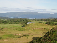
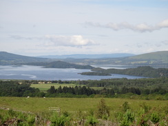
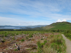
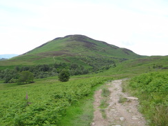
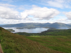
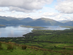
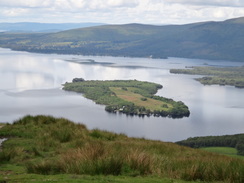
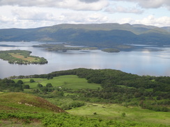
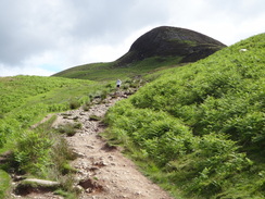
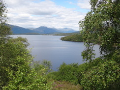
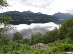
It was a relief when the gradient slackened and the path turned to skirt behind the summit of Conic Hill. The climb was well worth the effort, and the views across the southern end of Loch Lomond were superb. Instructive as well as superb, because the line of islands in the loch (and Conic Hill itself) are part of the Highland Boundary Fault Line, the ancient fault that divides the highlands of Scotland from the lowlands to the south.
A path leads up to the summit of the hill, but as I still had a long way to walk I chose not to visit it, and instead continued along the trail. This slowly started falling, the descent steepening down a zigzag path as it entered a little bealach between two summits. A runner came roaring past me as I did so - he had already run nineteen miles that morning and apparently had many more to go. He seemed to spring effortlessly down the hill - a nimble-footed feat I will never be brave enough to match.
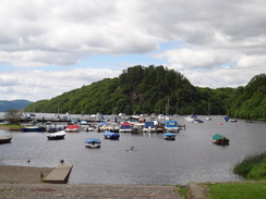
The descent seemed to be rather long, enlivened slightly by a rather attractive young lady climbing in the other direction whose trousers hung low around her bottom, exposing a thong. The trail entered an area of forest that dumped me out unexpectedly into the large car park in Balmaha. I was feeling fit despite the exertion of the climb past Conic Hill, but as I needed water I nipped into the visitors centre. Three men were sitting inside and I chatted to them for a while about the trail and one of them kindly filled up my water bottle.
I spent longer than I expected in the visitors centre, and after I left I was surprised to find that the village pub, the Oak Tree Inn, was open. After dropping my pack off at table outside the pub I went in and got my usual drinks along with a bacon and egg bap. I then went outside and chatted to passers-by in the sunshine. Time passed and my glasses emptied; after about half an hour I noticed that the other people who had ordered food after me had received theirs whilst mine remained strangely absent. The barmaid eventually sorted things out and I got my food. There was a significant delay, however, and I set off much later than I wanted considering the distance left to go.
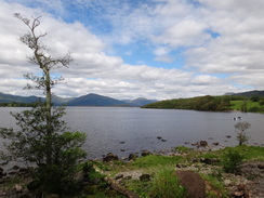
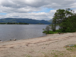
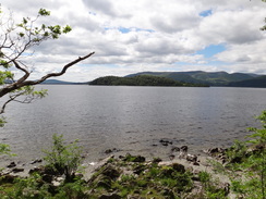
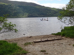
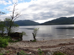
There were some great views over Loch Lomond towards the wooded islands that lie offshore. Several boats were plying up and down the loch and I found myself hoping that the many miles along the loch would provide many such views. Sadly the trail took me away from the shore, climbing steeply up a wooded hillside to reach Craigie Fort. I dont know if there was ever a fort at the summit but there was no obvious sign of one amongst the trees. A few glimpses of the loch were available as the path descended back to the shoreline.
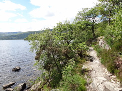
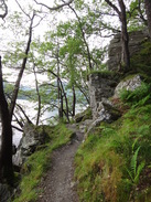
What followed was an incredibly bitty walk northwards along the eastern bank of the loch. This section of the trail was characterised by superb views over the loch and annoying steep descents and ascents past wooded hillsides. The car parks were far from full, but a fair few people were scattered around the beaches, enjoying the sunshine and the stellar views. Unfortunately I was feeling rather hot and bothered and so I just plodded on, the constant little climbs taking their toll on my legs.
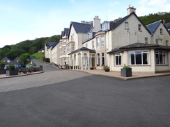
It was with relief that the Rowardennan Hotel hove into view. The youth hostel half a mile up the road was a possible stopping place for the night, so I decided to stop off for a rest. I dropped my pack off at a table and went to the bar. A rather gruff man behind the bar sullenly poured me my drinks and took a food order. I sat down and waited for the food to come - it was not particularly good; the burgers meat was dry and the bread tasted rather stale. As sati ate a rather attractive young woman asked the barman to fill up her water bottle, which he did whilst giving her some of the friendly chat that the hotel commented on in a plaque by its door. However a few minutes later I asked the same question only to be impolitely told to fill it up from a tap outside! Slightly hurt and very annoyed, I did as requested. The tap did not appear to be particularly well used so I let the tap run for a while before filling my bottle. However this might have had consequences later...
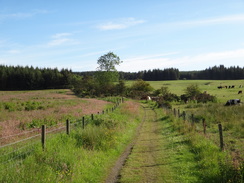
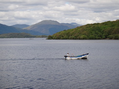
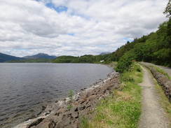
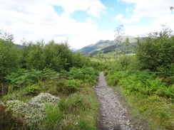
My mood did not lift as I followed a track northwards towards Rowardennan Youth Hostel. This was not due to open until five; if it had been open I may have stopped there but instead I plodded on, hoping to either camp at Rowchoish Bothy or near Inversnaid. At first the track was a pure joy to walk along; it was good underfoot and wide with few steep gradients. After Ptarmigan Lodge it started to climb up with occasional sublime views over the loch; several boats were plying up and down the loch and I found myself wishing that I was on one of them.
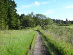
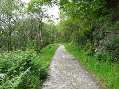
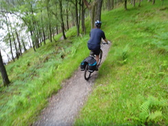
Sadly the good track did not last forever and it eventually became a path that started to climb and fall with annoying regularity. Indeed I was feeling slightly nauseous for some reason and I slowed down a little. The turn-off for the bothy was not obvious so I plodded on along the path that became increasingly enclosed by trees. Three off-road cyclists passed me, followed a while later by three more. The latter group appeared to be having a little trouble and they stopped just ahead of me to relieve tired muscles. Feeling a little like a tortoise against their hare I passed them, only to have them pass me as the Inversnaid Hotel came into view.
The path crossed two bridges over spectacular streams just before the hotel, and I descended the steps and entered the hotel. There is a camping spot a little further on, but after nearly twenty-five miles I felt in need of a little luxury. The hotel did not have any rooms but the man at reception told me that they run a bunkhouse up the road. As it was literally up the road he organised a lift for me. I sat outside and waited, feeling slightly underdressed amongst the hotels smart clientele.
The Inversnaid bunkhouse is one of the odder places I have ever stayed at; an old converted chapel, it has bunk rooms downstairs and a bistro upstairs. Sadly there was nowhere to cook and so I had to buy a meal - not a great hardship as the food was very good, but it hardly felt like a bunkhouse. Two men - perhaps a father and a son - were sharing the room with me, as was an older women who was doing a round of the Corbetts. We chatted as I ate my meal, washed down by a couple of beers before I went to have a shower. Unfortunate noises were erupting from my bowels and my guts were not feeling too healthy.
 |
 |
|
Directions
This walk starts off at the campsite at Easter Drumquhassle Farm. Leave the farm and turn left to head north along the road, climbing to reach a summit. It descends down the other side before curving sharply to the left; immediately before the low stone walls of a bridge are reached turn right down three steps to reach a footbridge over a stream. Cross this and take a footpath that leads up to the top of a small hillock. On the other side the path descends to cross some boggy ground before climbing uphill, initially with a stream on the left; aim for a gate in the upper-left corner of the field. Go through this and another gate to reach a slope that leads down to the A811 at NS482888.
Drymen is about half a mile away to the left; to reach it turn left and follow the A811 westwards before turning right up the B858. This soon curves to the left to head westwards into the village.
From NS482888 cross the A81(T) and head up a slope to reach a dead-end stub of an old road. Turn right for about ten yards to reach the end of the road and then turn left to join a path that is separated from the main road on the right by a hedge. The path ends at a gated track but a pavement continues on along the main road. Shortly after passing a farm entrance on the right, turn left through a wooden gate to join a path that runs northwards between fences towards woodland.
After the woodland starts on the left, go through a gate and continue on with woodland on the left and a fence on the right. After half a mile the path reaches a track junction at NS487898 within Garadhban Forest. Turn left along this track and follow it northwestwards through the woodland. After 0.7 miles it squeezes past a metal vehicle barrier gate to reach a road at NS480906.
Turn left to head down this the road for a few yards and then right up another track that leads back into the forest. It passes a small car park on the left and goes through another metal barrier gate. Stay on this good track as it winds westwards through the woodland for 1.8 miles; navigation is easy except for one point: when the track forks do not take a track that heads downhill, but follow the main track as it curves to the right. It crosses a couple of concrete bridges over streams and goes through a metal barrier gate to reach a triangular junction of three tracks at NS455912.
Here the route splits; a low-level route heads off to the left whilst the main high-level route climbs up towards Conic Hill. The main route crosses a track and takes the right-hand side of the junction to reach another track. This curves half-right to ascend northwards through the woods. It goes through a gate in a deer fence to enter an area of newly-planted trees (2011). The path winds around in a rough northwesterly direction with good views towards Conic Hill and the southern end of Loch Lomond. Cross a gate through another deer fence to leave the northwestern corner of the woodland. Turn right on the other side to head north along a rough track that crosses some moorland with a fence on the right.
The path soon curves to the left to head westwards across the moor with a ramshackle stone wall on the right. Carefully cross a footbridge over a stream and continue to reach a stile across a fence; the obvious path soon curves to the left to head southwestwards to descend steeply to reach the Burn of Mar. Cross the footbridge over the stream and continue westwards uphill along some steep steps. The gradient slackens as the rough path curves to the left to pass the eastern end of Conic Hill. It summits behind the hill before slowly descending as it heads southwestwards with the mass of the hill on the left.
Just before the path reaches a little hillock ahead (NS423918) it curves to the left to head down a zig-zag slope through the Bealach Ard before curving to the right to take a southwesterly course down some more steps. The gradient slackens before the path reaches a stupidly narrow clapper gate. Go through this to enter an area of forest; the path descends some steps before sloping downhill. After a quarter of a mile turn right along a track. This soon curves to the left to head south; as it turns to the right once more turn left to take a sloping path that heads south into a car park. Head through the car park, passing the visitors centre on the left to reach the B837 road in Balmaha at NS420908.
Follow an unsurfaced path that runs to the left of the B837 as it heads westwards, skirting past a little inlet in the loch. A low stone wall guards the path from the road. As the road curves to the right uphill head straight on along a minor road that leads towards Balmaha Pier. After a short distance turn right up some stone steps that lead up the wooded hillside. When the steps end a slope continues up to reach the summit of a hill called Craigie Fort.
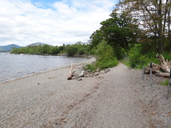
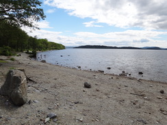
The path leaves the summit and slowly curves to the right as it descends steeply towards the foreshore along steps and a slope. The path forks as it nears the foreshore; take the right-hand fork to follow the shoreline northwestwards; it soon reaches a field that is sometimes used as a car park at NS415914. Continue past the field / car park and head on along the path. At times this passes through woodland at others through clearings; it is generally flat, with only a few minor ascents and descents as it heads around Arrochymore Point. The path eventually emerges into the Millarrochy car park, with a visitors centre and toilets on the right at NS411921.
Continue through the car park to take a gravel park that leads to a footbridge over a stream. On the other side of the bridge turn left to join a path that skirts the foreshore. Head along the foreshore, crossing a little stream that trickles down the beach. Keep some black railings on the right until the northern end of the bay is reached and then join the road at about NS409926.
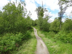
The trail follows the road northwestwards. Just before the Milarrochy caravan park is reached on the left a path starts on the right-hand side of the road; the path underfoot is good and easy to follow. It passes the campsite at Milarrochy and rejoins the road to reach a bridge over a stream; continue on and take the second exit to the left by a large Ben Lomond National Memorial Park sign.
This path goes through trees as it parallels the road on the right. It crosses a footbridge over a stream and starts to climb uphill to reach a surfaced track. Cross this and head up some steps; this is the start of an undulating stretch of path that heads through the trees towards the summit of Cnoc Buidhe. The path curves to the right to head north-northwestwards, descending to cross a stream on a bridge before taking a more northerly course to rejoin the road at NS397938.
Turn left down the road for a few yards, then turn right to join a path that runs northwestwards paralleling the road on the left. It heads slightly through the wooded hillside after crossing a footbridge over the Cashell Burn before descending to the road once more. Continue along the pavement for a short distance before the path heads away slightly to the right before rejoining the road just past a campsite. Cross this road and continue on along the pavement with the waters of Loch Lomond to the left. When it reaches the bridge over the Tigh-an-Loaoigh burn the trail joins the road to head uphill for a short distance
At Sallochy (NS389950) the trail leaves the road and takes a long, looping path through the woodland between the road and the loch, initially climbing steeply uphill before slowly descending downhill, eventually reaching Sallochy car park at NS380957, from where there are some grand views over the loch.
Walk through the car park and at the far end turn left along a path that crosses a footbridge over a stream. It passes a path leading to a small boathouse by a bay at NS376959, passing behind the boathouse and continuing beside the shore. After a short distance the path forks; take the right-hand branch and follow it as it heads steeply up the hill along a stony path. It then descends northwestwards to reach a boardwalk that crosses boggy ground to meet the foreshore at Mill of Ross.
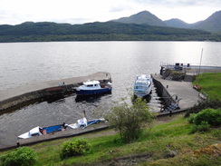
The trail skirts the shoreline northwards for a short distance, crossing two streams on footbridges before climbing a hill; it descends down stone steps back towards the loch side to reach an inlet called Lochan Maoil Dhuinne. The path continues to roughly parallel the shoreline northwards for another half mile, regularly climbing and falling before reaching a road at NS361980. Turn left and follow the roads pavement northwards, passing the Rowardennan Hotel on the left to reach a large car park near Rowardennan Pier at NS358986.
From the car park near Rowardennan Pier at NS358986, head along a good track that runs behind the visitors centre. This heads northwards through woodland towards the Youth Hotel. Before the track enters the grounds of the hostel turn right to remain on the track. When the track forks a few yards later, take the left-hand branch to continue on through the woodland.
The track passes a couple of buildings on the right before rejoining the shoreline once more as it heads northwards. When it forks after three-quarters of a mile at NN355006 take the right-hand branch (the left branch leads to Ptarmigan Lodge). Immediately go through a metal vehicle barrier and continue along the track uphill. A couple of hundred yards further on the trail itself forks.
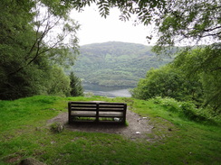
The right-hand fork follows an obvious track northwards up and along the hill; the going is easy as it continues to climb to a summit with a bench on the left before starting to descend. About 2.5 miles after Ptarmigan Lodge it reaches a bridge over the Allt Doirean at NN338038; here the track loops around to the left in a horseshoe before curving to the right. It becomes a path that quickly degenerates underfoot; after another half-mile of uneven terrain it rejoins the low-level route near Rowchoish bothy at NS338047.
The left-hand fork takes you down stone steps to the foreshore, which it follows northwards. In places the going is hard and it would be unwise to follow it if carrying a large backpack. After two miles the path heads away from the shoreline slightly, passing Rowchoish Bothy and meeting with the high-level route at NS338047; this junction can be hard to find from the high-level route.
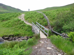
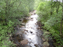
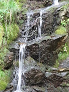
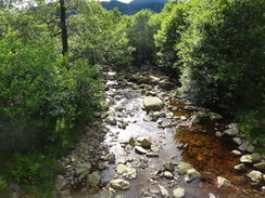
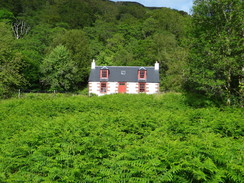
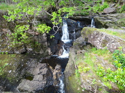
From here a path hugs the shoreline northwards through woodland. It crosses the Cailness Burn on a footbridge and immediately passes a beautiful whitewashed cottage on the right. The next 1.7 miles northwards are very rough; the ascents and descents are never too high, but the path underfoot is rocky. Eventually the path crosses the magnificent Arklet Water via a couple of footbridges to reach the Inversnaid Hotel; immediately after the second footbridge turn left down a long flight of steps to reach the front of the hotel at NN337088.
 |
 |
|
Distances
| From | To | Distance (m) | Ascent (ft) | Descent (ft) |
|---|---|---|---|---|
| Easter Drumquhassle | Balmaha | 8.5 | 1539 | 1631 |
| Balmaha | Rowardennan | 7.8 | 1345 | 1325 |
| Rowardennan | Inversnaid | 7.6 | 2077 | 2110 |
This makes a total distance of 23.9 miles, with 4961 feet of ascent and 5066 feet of descent.
For more information on profiles, ascents and descents, see this page
Accommodation
I spent the night at the Inversnaid bunkhouse, which is situated in a nineteenth century chapel about half a mile up the hill from the Inversnaid Hotel. It is one of the more unusual bunkhouses, with a bistro upstairs. They have a website at http://www.inversnaid.com/.
 |
 |
|
 |
 |
|
 |
 |
|
 |
 |
|
 |
 |
|
 |
 |
|
 |
 |
|
 |
 |
|
 |
 |
|
 |
 |
|
 |
 |
|
 |
 |
|
 |
 |
|
 |
 |
|
 |
 |
|
 |
 |
|
 |
Disclaimer
Please note that I take no responsibility for anything that may happen when following these directions. If you intend to follow this route, then please use the relevant maps and check the route out before you go out. As always when walking, use common sense and you should be fine.
If you find any information on any of these routes that is inaccurate, or you wish to add anything, then please email me.
All images on this site are © of the author. Any reproduction, retransmissions, or republication of all or part of any document found on this site is expressly prohibited, unless the author has explicitly granted its prior written consent to so reproduce, retransmit, or republish the material. All other rights reserved.
Although this site includes links providing convenient direct access to other Internet sites, I do not endorse, approve, certify or make warranties or representations as to the accuracy of the information on these sites.
And finally, enjoy your walking!
Nearby walks
| # | Title | Walk length (miles) |
|---|---|---|
| 462 | Rosneath to Ardgartan | 26.5 |
| 463 | Ardgartan to Carrick Castle | 17.4 |
| 905 | West Highland Way: Milgavie to East Drumquhassle | 11.1 |
|
|

|