Walk #463: Ardgartan to Carrick Castle
 |
 |
|
General Data
| Date Walked | 05/06/2003 |
| County | Strathclyde |
| Start Location | Ardgartan |
| End Location | Carrick Castle |
| Start time | 10.18 |
| End time | 17.19 |
| Distance | 17.4 miles |
| Description | This was a nice and enjoyable day, and unlike recent days the majority of it was off-road, which I am quite thankful about. |
| Pack | Today I carried my 30-litre Karrimor HotRock rucksack, which was filled with my packed lunch, waterproof leggings, water bottle and a couple of spare shirts, together with the usual assortment of odds and ends. |
| Condition | I feel absolutely fine after this walk, and have no significant problems to report. This is to be expected after such a short walk, particularly when compared with recent days. |
| Weather | Aside from two light showers, the day was dry and at periods sunny. It was also quite warm, with not a great deal of wind to help cool me down. |
| OS map | Landranger number 56 (Loch Lomond & Inveraray) |
 |
 |
|
 |
 |
|
Map of the walk
Maps courtesy of Google Maps. Route for indicative purposes only, and may have been plotted after the walk. Please let me have comments on what you think of this new format. For a detailed table of timings for this walk, please see the table file.
 |
 |
|
Notes
After the exertions of yesterday, this was a much shorter and relaxing day. The scenery was at times stunning, and this made the many little ascents more than bearable. I left the campsite quite late, as I was aware that this was going to be a short walk and that it would not take too long. It also gave me the opportunity to do some work on the computer before I left, as next time we stay at a campsite I want to be able to send a CD off to Terry so that he can update the website for me.
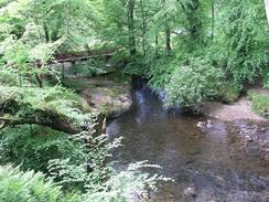
My first aim was to walk up the visitor's centre that is just off the A83(T). Fortunately there is a very nice footpath to the centre through a wooded area that totally avoids the main road, and only the noise of the occasional lorry made it presence felt. It was a lovely introduction to the day, and I took my time to savour the sights and the sounds of the woodland and the stream that was adjacent to the path.
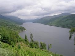
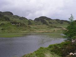
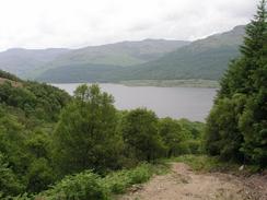
There are many tracks through the forest, and this had made planning this section of the walk reasonably hard. In particular, the tracks at the southern end of the peninsular were not continuous, with a horizontal gap of a few hundred metres and quite a considerable vertical gap between the ends of the two tracks. Sam went to a visitors canter yesterday and had found out that there is a cycle path around the peninsular that passes Corran Lochan, about a mile north of the southernmost point. I decided to follow the cycle path, and about half an hour before I reached the Lochan I met a couple who were out walking. He has completed all the Munroes, and we had quite a chat, and during this he stated that there is absolutely no way around the south end of the peninsular, so I was glad of my decision. The cycle path is called the Dukes Pass Drove Road, and it is all over obvious tracks, although it is a bit steep in places on the descent from Corran Lochan to the side of Loch Goil. In one place the path was being restored, and the alternative was a hard and steep descent virtually straight down the hillside. There were some great views from the area around the Lochan, and I enjoyed the walk through the area of moorland that follows before the path plunged back down into the forest. This is definitely an area that I would like to come back and visit some other time and climb some of these peaks, particularly The Cobbler.
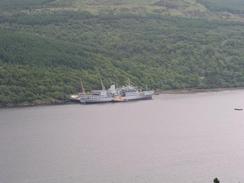
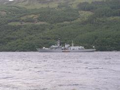
I got a good view down onto the Royal Navy ship 'Fort Austin', which I saw yesterday docked beside Loch Long. Although it was on the other side of the loch I could see it in detail, and it was totally incongruous with the loch and the mountains behind it. It seems like a totally unsuitable place to see a warship moored, especially if you did not know of the ammunition depot a few miles away at Coulport.
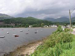
As usual, I met Sam at lunchtime (at least, it was a very late lunch) in Lochgoilhead. This small village sits nicely at the end of Loch Goil, and it is difficult to imagine that it lies only thirty miles from Glasgow as the crow flies. To get there from the Erskine Bridge (probably about five miles out from the centre of Glasgow, and twenty-five from Lochgoilhead) I have walked about sixty-seven miles - an amazing thought, especially as I have done it in about three days! This situation is only going to get worse, with many miles to be walked up and down sea lochs until I eventually reach the Mull of Kintyre.
The last few days have seen me thinking about some fairly strange and esoteric things. In particular my mind has been going back eleven years, when I was living in London, my future appeared to be in civil engineering, and the idea of even being able to walk 5,500 (or more) miles was a dream that seemed impossible to achieve. It was a time when my left ankle was causing me considerable pain, I was undergoing weekly physiotherapy, and when the act of taking a step would mean sharp, intense pains to go shooting through my leg. I am now very much a different person to the lad - perhaps child - I was then, and all of this change has been due to the fact that my ankle is no longer in that state. I spent about thirteen years in periodic pain with the ankle, and had five or six operations on it during that period. During the most formative periods of my life I spent up to three months at a time with my left leg in a fibreglass cast whilst everyone around me was playing rugby or cross-country running. Sometimes walking without pain seemed an unachievable goal, yet alone what I have achieved so far on this walk.
So how have I managed to get to where I am now? Firstly, a great surgeon fixed my ankle in May 1998, hopefully for good. Secondly - and I do not mean this to sound immodest - I had the mental strength to ignore the last thirteen years. A day after my last operation I gave myself the target of walking the Pennine Way (a lifetime dream of mine) within a year, and fifteen months later I had completed it (the delay was so that I would have an excuse to miss the wedding of a friend). That one mental step of being able to ignore the pain of the past, of being able to ignore the risk of buggering my ankle up again, and to set out and do the walk, has probably done me more good than anything else in my life. I am a different person today - settled, self-confident, and almost immeasurably happier. I have truly been exceedingly lucky.
We are meeting a couple of friends of ours who are coming up from Cambridge tomorrow night, which should be fun. As a result of this I intend to start quite early tomorrow so that I can finish as early as possible, and then meet up with them. Seeing people from Cambridge will bring me down to earth, as that part of my life seems a very long time ago, despite the fact that I saw another friend a couple of weeks ago at Stranraer. I have been planning my walks over the last few days to reach Dunoon by tomorrow night, and although it has meant some long days it has been well worth it.
Directions
This walk starts off from the campsite at Argartan Campsie, which is beside the A83(T) road. Head up the driveway from the campsite and just before the A83(T) is reached turn left along a track that runs northwestwards through a very pleasant wooded glade, with Croe Water on the left and the road on the right. It is possible to make a small shortcut by crossing a bridge over the stream to the left, but I continued on until I reached the visitors centre for the forest.
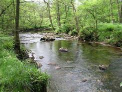
At the visitors centre I turned to the left to cross Croe Water on a bridge, and on the other side turn left down a surfaced track. This is the start of the Dukes Pass Drove Road, which is also a cyclepath. Follow the surfaced road as it curves to the right slowly to head southwards through Ardgartan Forest. It passes to the right and above of another campsite, and as it approaches Coilessan the surfacing ends and the track head uphill. From here the path continues on for five or six miles southwestwards towards Corran Lochan - the tracks to the lochan are obvious on a map, although they are not well signed on the ground. The path climbs and falls, but it is always broad and reasonably firm underfoot.
At Corran Lochan turn right down a far rougher path that skirts the eastern side of the lochan before climbing through some moorland, which has some lovely views over the surrounding hills. The track heads northwards across the moorland, before entering the woodland once more and then descending steeply downhill and meeting a track above Stuckbeg. Turn right along this track and follow it as it descends to meet a firmer road by the lochside. Follow this track northwards for a couple of miles into Lochgoilhead. Walk through the village until the bridge over the River Goil is reached, and immediately on the other side turn left down a minor road. This passes a series of chalets on the right before continuing southwards for about five, passing a Qinetiq base on the left and eventually reaching Carrick Castle. This walk ends at the car park directly opposite Carrick Castle.
Distances
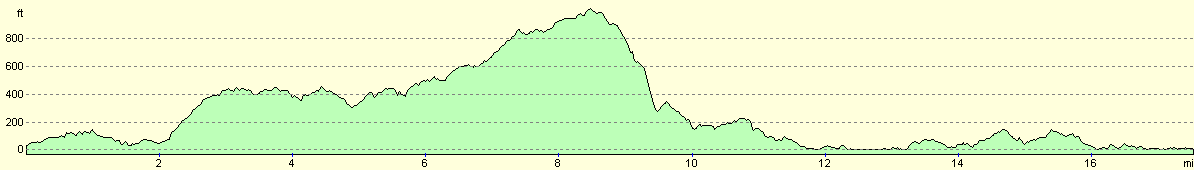
| From | To | Distance (m) | Ascent (ft) | Descent (ft) |
|---|---|---|---|---|
| Ardgartan | Corran Lochan | 7.5 | 1778 | 968 |
| Corran Lochan | Lochgoilhead | 4.4 | 591 | 1411 |
| Lochgoilhead | Carrick Castle | 5.5 | 676 | 696 |
This makes a total distance of 17.4 miles, with 3045 feet of ascent and 3075 feet of descent.
For more information on profiles, ascents and descents, see this page
Accommodation
We parked Mervan in a car park right opposite Carrick Castle. This was immediately adjacent to a sign that state no overnight camping, but we chose to ignore this. There were some public toilets a little distance down the road, and so this did us fine for the night.
Disclaimer
Please note that I take no responsibility for anything that may happen when following these directions. If you intend to follow this route, then please use the relevant maps and check the route out before you go out. As always when walking, use common sense and you should be fine.
If you find any information on any of these routes that is inaccurate, or you wish to add anything, then please email me.
All images on this site are © of the author. Any reproduction, retransmissions, or republication of all or part of any document found on this site is expressly prohibited, unless the author has explicitly granted its prior written consent to so reproduce, retransmit, or republish the material. All other rights reserved.
Although this site includes links providing convenient direct access to other Internet sites, I do not endorse, approve, certify or make warranties or representations as to the accuracy of the information on these sites.
And finally, enjoy your walking!
This walk was mentioned in the following routes:
| My walk around the coastline of Britain |
Nearby walks
| # | Title | Walk length (miles) |
|---|---|---|
| 461 | Dalreach to Rosneath | 22.2 |
| 462 | Rosneath to Ardgartan | 26.5 |
| 464 | Carrick Castle to Dunoon | 19.6 |
|
|

|