Walk #1030: London Loop: High Barnet to Loughton
 |
 |
|
General Data
| Date Walked | 01/01/2019 |
| County | Essex, London |
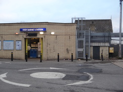
| Start Location | High Barnet station |
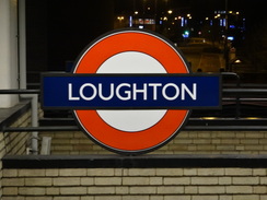
| End Location | Loughton station |
| Start time | 08.39 |
| End time | 15.59 |
| Distance | 20.7 miles |
| Description | This was a very pleasant section around the northernmost stretch of the London Loop. |
| Pack | Today I carried my 30-litre Karrimor rucksack, filled with water, my spare waterproofs, a book and other odds and ends. |
| Condition | I feel rather tired after this walk, but was otherwise fine. |
| Weather | Today started off with a mixture of sunshine and cloud, and that is pretty much how it continued for the rest of the day. It was unseasonably warm for the time of year. |
| OS map | Landranger number 176 (West London, Rickmansworth & Staines) and Landranger number 177 (East London, Billericay & Gravesend) |
 |
 |
|
Map of the walk
Maps courtesy of Google Maps. Route for indicative purposes only, and may have been plotted after the walk. Please let me have comments on what you think of this new format. For a detailed table of timings for this walk, please see the table file.
 |
 |
|
Notes
I did my first walk for this website twenty years ago today, and it felt fitting to go out and do another walk. I was tempted to go up to the Peak District to reproduce that first stroll, but I had done some of it recently, and so decided to start a new trail along with the new year. I have wanted to do the London Loop trail for some time, and purchased a guide book for it years ago, but had never quite got around to it. After my recent computer problems wiped out many of my planned walks, it seemed like a good opportunity to start that trail.
I got up early to drive down the M11 to park at Loughton station. The journey to the start of the day's walk in Barnet went swimmingly until the tube train pulled into Bank. I had hoped to get an immediate train to North Barnet, but one was not due for twenty minutes. Instead I caught a train to Camden Town and changed there, waiting amongst the very last of the new year revellers. This meant I arrived at North Barnet about half an hour after sunrise – potentially a problem for a long walk this near the shortest day.
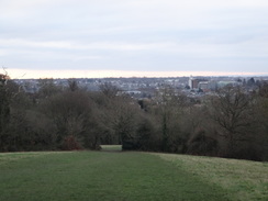
I headed down a busy road towards the trail, and soon came across a pleasant surprise – a large signboard giving information on this stretch of the trail. This would be repeated several times during the day, and it is clear that the local boroughs take some interest in the trail. A waymarker pointed me up a local road, after which the path headed across greenery with the station's sidings visible through the trees. This led to a road, and then a climb up King George's Field, which gave some pleasant views south over London from near the top.
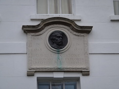
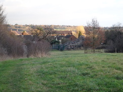
At the top another road led through Hadley, which is apparently the site of a battle in the civil war, although I doubt any of the residents in the expensive-looking houses surrounding the green would welcome any war. One house had a little plaque saying that the famed explorer Livingstone had lived in it, and apparently the church has an Elizabethan beacon on its roof. It was all very pleasant and utterly middle class.
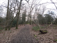
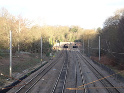
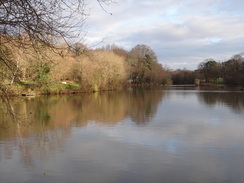
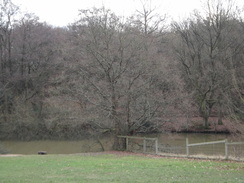
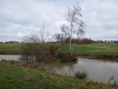
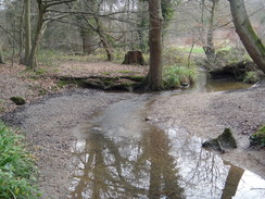
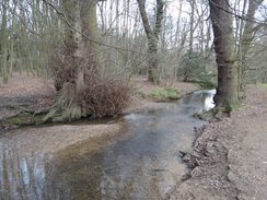
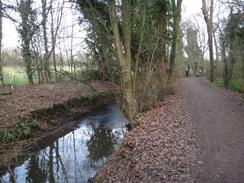
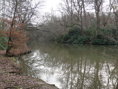
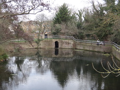
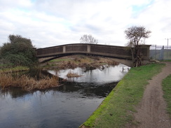
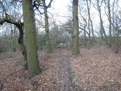
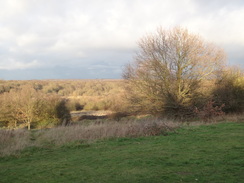
A path skirted the road across the edge of Monken Hadley Common, a pleasant stroll that ended at a track that led to a bridge over the East Coast railway line, with the portals of Hadley Wood South Tunnels visible in the distance. One of the two tunnels was dug as late as the 1950s, as part of a project to quadruple the tracks through Potter Bar to relieve congestion. The trail continued on through trees, and I enjoyed the stroll towards a bridge that was defaced with graffiti and had a generally down-at-heel air. The guidebook recommended heading off the path for a short distance to look over Jack's Lake, and this proved to be well worth the diversion.
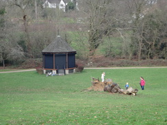
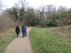
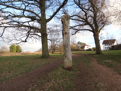
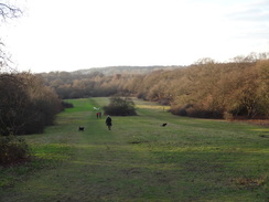
The path led to roads, and on one of these a man came past me with rucksack, gaiters and a determined look on his face – we did not exchange words, but he was obviously on a hike. The roads took me past a church and then onto Cockfosters tube station, and I nipped into an adjacent garage to buy some sandwiches. The path then skirted the side of a cemetery, before entering Trent Country Park, where a small obelisk stood near the visitors' centre. The trail passed through the park, and I went a little wrong for a few metres, following a path uphill rather than heading along the track past a lake. It was all very pleasant, and there were plenty of people enjoying the unseasonably warm weather.
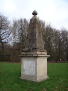
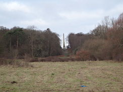
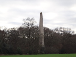
The trail eventually emerged from the trees onto a road near a much larger 18th-Century obelisk that was originally in Wrest Park in Bedfordshire, and was moved to its present location in the 1930s. The next few miles followed paths alongside the Salmon Brook before heading up to meet The Ridgeway at the northern side of Enfield Town. The trail nearly entered the town, before following a track that passed a farm, complete with the sound of guns erupting from a nearby copse, before climbing up under a railway bridge and on into Clay Hill. A marker on a post showed that the route here has changed since my guidebook was published; instead of going around two sides of a recreation ground, it heads to the church and then down to reach the seasonably-named Turkey Brook. As with much of today's walk, the route is very well waymarked.
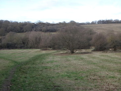
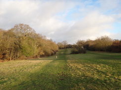
It is surprising quite how rural London can be. Today was spent entirely within the M25, and yet the majority of it was spent in greenery. For much of the time the background hum of road noise was the only intrusion of civilisation. It was proving to be a delightful day's walk, with a grand variety of terrains and plenty to see.
I followed the Turkey Brook eastwards for several miles, initially past a series of parks that were popular with walkers. At one point it crossed the old course of the New River – the New River itself being rather old, and its old course older than the newer stretch of the New River that replaced it. With such thoughts echoing around my empty skull, I strode on along good paths that were filled with yet more people enjoying the day, or perhaps burning off the excesses of Christmas. Whatever their reasons, everyone seemed to be in a good mood.
The trail crossed a road near a Maiden's Bridge where – apparently – Sir Walter Raleigh famously laid down his cloak so Elizabeth 1st would not get dirty. Whether or not it really happened, he probably wished the bridge had been there. A little further on a bump in the ground crossing the path marked the course of the new New River course. This was conveniently buried underground, perhaps so no queen will have to muddy their feet.
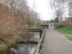
This was the end of the scenery for a while, as the trail crossed a busy road and passed a crematorium before crossing yet another railway line. It then followed a road through Enfield – although at least the road was the topically-named Turkey Street, with the eponymous stream flowing immediately alongside. Roads took me on to a rather boring stretch of path beside the culveted brook, with houses backing onto the opposite bank whilst the path ran alongside parkland. Another footbridge took me over a railway line – by now I was losing count of the number I had crossed – and headed on towards Enfield Lock, on the Lea Navigation.
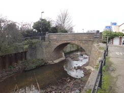
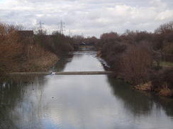
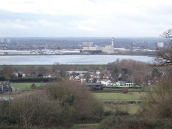
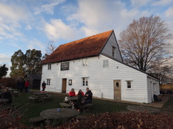
I have walked this stretch of the navigation a few times, the last for a walk on this website many years ago. The trail followed the navigation south for a short distance towards the massive King George's Reservoir, before passing a low bridge that once carried a railway line into the Royal Small Arms Factory. The factory itself has since been redeveloped for housing, leaving the bridge as an odd reminder. An ugly concrete bridge over an inlet was followed by a second, equally ugly bridge, and then by a rather more pleasant arched bridge over a flood-relief channel. Sadly I could not get a good photo of this, as the path was tightly constrained between fences.
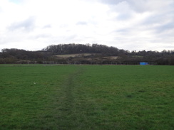
The trail followed a track east towards a main road in Sewardstone, after which it started climbing uphill. This was a slightly annoying stretch, with the path blocked by tree trunks that had been deliberately placed over the track, and then later hedges that had been ripped up. Even the rather good views west over London did not make up for it, but my mood was probably more influenced by the fact I was drastically running out of energy. Whereas my previous walk from York had seen me yomping for long periods, today I found that just walking was tiring.
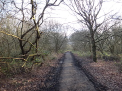
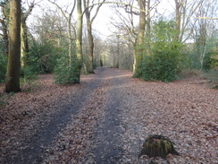
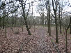
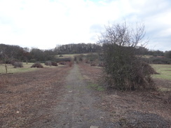
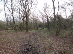
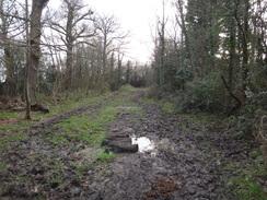
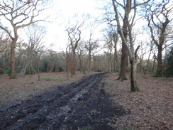
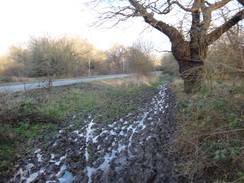
A really muddy stretch of footpath that avoided a road made me wish I had chosen to follow the road instead, after which an access road took me to the gates of Gilwell Park, the world headquarters of the scouting movement. The path past the site was again very muddy, and the descent into a little valley proved difficult without walking poles. This was followed by an ascent up the other side of the valley, and a muddy walk through woodland back to the road. The whole diversion past the scout camp felt remarkably unnecessary, a long and muddy stroll that offered little advantage – although it may be a very different experience in spring or summer.
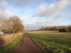
Waymarkers pointed me to a path that paralleled a road south from Sewardstone towards Chigwell Green, after which a pleasant (and popular) path took me near Queen Elizabeth's Hunting Lodge and up past a pub. Another stretch of path through the trees beside the A1069 proved to be incredibly muddy, and I actually walked along the road for a short distance to avoid the worst stretch. Things improved as the trail climbed a hillside with some good views back west, but this ended after a main road dumped me back into suburbia.
It was starting to get dark, and I hurried past houses and down a long, constrained path to a footbridge over the Central tube line. A few metres further on I left the trail and started the mile-long walk up to Loughton station, by which time it was pretty dark.
It had been a very enjoyable day's stroll, with much of interest to see and do. I am very much looking forward to doing another stretch of the London Loop.
 |
 |
|
Directions
This walk starts off at High Barnet tube station, at TQ25039614. Leave the station by its main entrance, and follow its access road that slopes up to reach the A1000 road. Turn left to head down this road; the pavement is on the right. Just before a railway bridge at the bottom of the hill, the London Loop trail comes in from the right.
Continue under the rail bridge, and immediately on the other side at TQ25379585, carefully cross the road using a pedestrian crossing and turn left up Potters Lane. The road ascends, with a pavement on the right and railway sidings away down to the left. At the end of a right-hand bend after 240 metres, and just before houses on the left start, turn left off the road and descend a slope to reach an area of grassland. Skirt a hedge on the right with the grassland on the left; this passes the end of a road on the right and joins a surfaced path. Follow this until a house is reached on the right; here angle right down a path that heads across the middle of a triangle of grass to reach Meadway at TQ25099636.
Turn right to head east along Meadway; after 250 metres turn left up Burnside Close. This curves to the right and when it soon ends, continue on along a surfaced path between fences. When the path ends at the end of Bosworth Road, turn left through a clappergate beside a field gate into an area of parkland called King George's Field. Follow a hedge on the left past the first field, and then follow the path as it curves left to cross a farm bridge over a stream. On the other side it curves right to climb uphill to the northwest. At the top of the hill, the path reaches a clappergate near a field gate that leads out onto Hadley Green Road at TQ24629713.
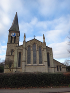
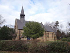
Turn right to follow Hadley Green road northeastwards; you can either follow the pavement or walk along the green parallel to the road on the left. After 400 metres the road ends at a T-junction with another road; turn right along this road, which soon ends at another T-junction. Turn right at this junction, to continue on down Hadley Green Road. This soon passes a church on the left, and then passes through a white gateway. Continue along this road as it heads southeastwards; 300 metres after the church at TQ25299723, and opposite a large house, turn left to join a path that immediately enters some woodland.
A few metres into the trees, turn right off the main path to join one that heads southeastwards, paralleling the road off to the right. After about 850 metres a car park is approached on the right; veer right into the car park. Follow a track leading east out of the car park; pass two vehicle barriers to reach a bridge over a railway line at TQ26309713.
On the far, eastern, side of the bridge, follow the track as it curves to the right to head southeastwards, slowly descending; it soon curves to the left to resume its easterly course through the trees. After 850 metres a 'pompous' bridge over a stream is reached, with Beech Hill Lake a short distance away through the trees on the left. Cross the bridge and continue east uphill along the track, avoiding a road on the right; 700 metres after the bridge, the path emerges from the trees into a small area of grassland; continue across this and join Games Road at TQ27759674.
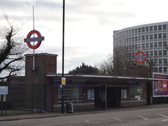
Turn left along games Road, immediately passing through another white gateway and then passing the Cock Inn on the right. Immediately after the Cock Inn, turn right down Verwood Drive. As this soon starts to curve right, turn left to continue straight on south along Chalk Lane. After 300 metres this passes a church on the right, and curves left to reach the A111 road opposite Cockfosters tube station. Carefully cross the road to reach the tube station at TQ28079640.
Head straight on along the station car park access road, with the tube station to the right; however after a few metres, angle left to reach a barely-visible gate that marks the start of a footpath. This heads east between the car park on the right and a cemetery on the left. When the cemetery ends, continue straight on for a few metes into a field, and then turn left, immediately crossing a plank bridge over a stream and heading on. It passes a relatively open area on the right, and just before the cemetery ends on the left, it enters some woodland. Follow the path through the trees; at a path junction turn left along another path. This soon curves right and descends to cross a plank bridge over a ditch and then emerges out into an open area. Follow the treeline on the right until it reaches a gap in a metal fence that leads out onto an access road. Cross the road ahead and turn right for a few metres to reach a small obelisk on a triangle of grass near the entrance to Trent Park at TQ28079687.
Pass the obelisk on the right, and continue along the access road as it enters a car park. Pass the Trent Park cafe on the left, and continue down a track that descends northeastwards through the trees. The track slowly curves right, and 600 metres after the car park crosses a little plank bridge and emerges out into a field. Follow a hedge on the left, and then turn left along a broader track, still with the hedge on the left. Continue along this track as it heads northeastwards, skirting a lake away to the right to reach a triangular junction of paths in front of trees at TQ28929764.
Head straight on along a broad track that heads uphill through the trees. The gradient slackens, and the track continues through the trees, slowly curving to the left. When a junction is reached, angle left along a path; do not continue along the track. Just before the path curves left near the edge of the woodland, turn right along a narrower path to reach a footbridge over a ditch that leads onto a road at TQ28629817.
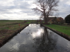
Turn left along the road, passing a tall obelisk away in the field to the left. After 100 metres, turn right to reach a plank bridge and clappergate that leads to a path that runs northwards between fences and hedges. This slowly descends past fields for a little over 500 metres, when it turns sharply right to head east between a hedge and a fence. When the corner of the field is reached after nearly 400 metres, turn right for a few metres and then left through a hedge to enter another field. Follow the path as it continues between a hedge on the left and a fence on the right. After 350 metres the path curves left to cross a farm bridge over the Salmon Brook at TQ29089885.
On the other side of the bridge, turn right to a clappergate that leads into a field. Follow a hedge on the right; at the corner of the field, go through a clappergate, cross a footbridge over a ditch and follow the path as it curves right through a slightly overgrown area that leads to a second clappergate. Go through this and head on along a broad grassy path, with the brook on the right and a fence on the left. This eventually reaches a stile beside a gateway; cross this and continue following the stream on the right until it curves right at TQ30039845.
When the stream curves right, continue following the edge of the field as it curves left to head uphill, with a hedge on the right and a fence on the left. Just before the road is reached at the top, turn right through a clappergate into an area of woodland and follow an obvious path that winds through the trees. It finally reaches another clappergate that leads into a field. Follow a hedge and road on the left; after about 200 metres, at the bottom of a dip, turn left across as stile to join the A1005 road at TQ30619834.
Turn right to follow the road southeastwards; there is a pavement on the left. It enters the northern outskirts of Enfield and passes the Royal Chace Hotel on the right. 250 metres after joining the road, turn left down a surfaced track that slowly descends for 500 metres to reach Rectory Farm. Pass the farm buildings on the right, and then follow the track as it curves right, passing a barn on the right at TQ30989873.
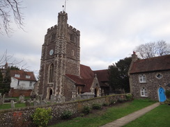
The track heads away from the farm and curves left to cross a stream (the Turkey Brook). It then climbs northeastwards, passing the Red House on the right. It heads past bollards and under a railway bridge before reaching a T-junction with another path. Turn right down this track, and follow it as it passes bollards and becomes Strayfield Road. 500 metres after the junction, a church is reached on the left at TQ31849886.
Immediately beyond the church, and just before the road curves left, turn right past a vehicle barrier to join a path that heads south. Follow this path as it heads downhill past a hedge on the left and enters a small, narrow field stretching down. After 370 metres, a footbridge over the Turkey Brook is reached at TQ31859848.
Cross the bridge, and immediately on the other (southern) side, turn left along a good path with the stream on the left. When a footbridge over the stream is reached on the left after 450 metres, turn right up a slope along a surfaced path that soon meets a crosspath. Here turn left to follow a path northeastwards as it slowly descends, with the stream down to the left. After 300 metres it joins another path, and both head on for a few metres to reach bollards that guard Clay Hill road at TQ32609864.
Carefully cross the road and head on past bollards to join a path, initially with a pub's car park on the left. The good path winds around alongside the Turkey Brook in a rough northeasterly direction. After about 250 metres it climbs a small bank to cross the New River's old course, and then drops down to continue following the Turkey Brook on the left. Continue following the stream on the left, ignoring any paths over the stream to the left. 2km after the road, a crosspaths is reached; head straight on for a few metres to reach Forty Hill Road at TQ34219873.
Turn right for a few metres to reach a pedestrian crossing over the road, and on the other side turn left for a few metres before turning right past some bollards to join a surfaced path that heads in a rough easterly direction between fences. This path crosses the New River (which is buried under a mound at this point), and after 400 metres it emerges out into the side of the A10(T) at TQ34639868.
Turn left to reach a footbridge over the road, and on the other side turn left past the bridge, and then immediately right along another path that initially passes a crematorium gardens on the right, with the Turkey Brook away to the left. After nearly 450 metres the path becomes a pavement of a road called Grenville Cottages on the right, and they both then plunge under a railway bridge. When the road ends at a T-junction, turn left up Winnington Road for a short distance until it too ends at a T-junction with Turkey Street. Turn right along Turkey Street, to head away from a railway bridge and Turkey Street station. After 400 metres, Turkey Street ends at a T-junction with Hertford Road at TQ35569868.
Carefully cross Hertford Road and turn right to follow it south. Take the first road off to the left, St Stephen's Road, and a few metres after this curves right, turn left to join a surfaced footpath. This heads eastwards, and the Turkey Brook soon joins it on the left. Follow the path and brook as an area of parkland called Albany Park starts on the right. After 650 metres a footbridge over a railway line is reached. Cross the footbridge, and on the other side follow a path with the brook off to the left for a few metres until a bridge over the brook is reached. Cross this, and on the northern bank of the brook, turn right to follow a path, now with the brook on the right. Newbury Avenue is soon reached at TQ36549840.
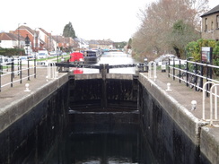
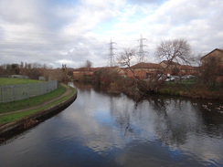
Cross this road, and continue on east along the path at the brook curves away to the right. The path splits; take the right-hand branch that climbs past vehicle barriers to a bridge over Mollison Avenue. A ramp descends, and the path continues straight on eastwards before ending at a road. Head straight on along this road for a few metres to cross a bridge over the Lea Navigation beside Enfield Lock at TQ37149832.
Immediately on the other (eastern) side of the bridge, turn right to join the canal's towpath. Head south with the water on the right, and after about 120 metres cross a footbridge over a little inlet, and then turn left past a gap in barrier to enter a car park. Go through the car park to its exit, and then veer right. Just before some gates through a palisade fence are reached, turn left to join a path that runs along the southern bank of the Lea. Follow this southeastwards; it passes a disused low railway bridge over the river, and then reaches a concrete bridge over a river stream. Turn left to cross this, and on the other side continue following the river on the left to a second concrete bridge. The path curves left to cross this, and on the other side curves slightly right to reach a long arched footbridge over a flood relief channel at TQ37649793.
Cross the bridge, and on the other side follow a surfaced path that immediately curves left. Ignore a path leading off to the left shortly afterwards, and instead continue along the main path as it curves right to head in a rough easterly direction. About 500 metres after the bridge, the path goes past a vehicle barrier and joins the end of Godwin Close. Follow Godwin Close east for another 250 metres until it ends at a T-junction with the A112 Sewardstone Road. Carefully cross the road, and then turn right to follow it south for less than 100 metres, until a gateway is reached on the left at TQ38269787, opposite Sewardstone Close.
Turn left to go towards the gate, but before it is reached turn right over a stile into a field. Angle diagonally across this field, aiming for trees on a hillside ahead. Go through what looks like (in 2019) a temporary fence and continue on to the far corner of the field. Here join a cinder track that immediately leads through a gap in a hedge. Continue straight on uphill southeastwards along the cinder track, still towards the trees on the hillside ahead. It then curves right and continues to climb, before meeting the edge of some woodland and turning left to follow trees on the right uphill. About twenty metres after the bend, turn right across a stile at TQ38639720 to enter the woodland.
An obvious path heads south through the trees, before emerging out across a stile into a field. Head on, following an edge of the woodland on the left. At the corner of this small field, turn left across a third stile and then angle right up a couple of steps up a bank to reach a bend in another cinder path. Note: in 2019 the next stretch was being worked on, with hedges uprooted, so directions may alter. Cross the bend, and angle right across a field, angling only slightly away from the track on the right as it crests the brow of a hill. At the end of this field it crosses the cinder track once again, and descend through a gap in a fence into trees. Do not join the road ahead, and instead after five metres turn left along a path that runs through the trees. The path soon leaves the trees into an area of grassland, and slowly curves right towards Carrolls Farm. It joins a surfaced track; turn right down this track to reach a road at TQ38869670.
Cross the road, and on the other side take a path that heads south through trees, paralleling the road away to the left. The path was very muddy, and it might be easier to follow the road instead. After 350 metres the path ends at a junction with Gilwell Lane. Follow the lane west for 250 metres until the gates of Gilwell Park are reached at TQ38699635.
The road ends at the gates; turn left along a surfaced track, and when this soon curves right towards a car park, head straight on past a vehicle barrier to join a muddy track. Follow this south; when it forks after about 150 metres, take the right-hand branch which falls downhill westwards through a band of trees. After another 350 metres, turn left off the main path to join a minor path that heads south. This climbs slightly through the trees, cresting the slope before descending down. Near the bottom it joins a wider track for a short distance. At the bottom turn right for about twenty metres to a footbridge over a stream at TQ38409575.
Cross the footbridge, and head straight on south across some grass, initially slowly climbing. Near the top of the slope, turn left along another path that soon dives into some woodland. Follow this path as it heads in a rough easterly direction through the trees, with a golf course a short distance away to the right. After 800 metres the path ends at a road at TQ39299557, just south of Sewardstonebury.
Carefully cross the road, and on the other side, go through the trees for a couple of metres to reach a good track. Turn right to follow this track south through the trees, paralleling the road to the right. After 500 metres the path emerges from the trees; turn right past a vehicle barrier, and then left, to continue south along a good path. It approaches a car park on the right; turn right into the car park and then leave through car park's entrance to meet the road. Turn left along the road; pass a cafe on the left until a right-hand bend is reached at TQ39369479.
Just before the bend, turn left along a footpath that initially passes a car park on the left. When a large path heads off to the left after 200 metres, angle right, taking the right-most of three paths. This climbs a slight slope, and then angles left. Turn right past a drinking fountain to reach Ranger's Road beside the Butler's Retreat pub at TQ39799477.
Cross the road, and on the other side turn left along a path that heads east, paralleling the road on the left. After 400 metres cross a track and then a hump-back bridge over a stream to enter a grassy area. Follow this path uphill eastwards, paralleling the right-hand side of the grassland; after 450 metres go through a bridleway gate beside a field gate to reach the A104 road at TQ40729478, with the Warren Wood pub immediately to the right.
Carefully cross the road, and on the other side go through a gap in a fence to join a path that runs east-southeastwards through a narrow gap between trees. The clearing ends and the path continues on through the trees; it emerges into a grassy area, with cricket pitches off to the left. Follow a hedge on the right, with blocks of flats beyond it, and then squeeze past a gap in a fence to reach the A121 road at TQ41039451.
Carefully cross this road, and pass a bus shelter on the right to reach a road called North End. Turn left along this road and follow it as it starts to sweep to the left, with a grassy area off to the left. Near the end of the bend after 250 metres, turn right down an access road that runs between houses. When this soon ends, turn left along a path that passes a house and garage on the left, and then runs between fences eastwards. Go through a clappergate; continue along the path alongside a fence on the right to reach a second clappergate beside a field gate. Go through this and head straight on to enter a field. Descend down the field, keeping a hedge on the left. After going through a gap in a hedge, angle slightly to the right down to a footbridge over a tube line. Go through a metal clappergate to reach the bottom of the footbridge at TQ41939458.
Cross the footbridge, and on the other side turn right down a short path that runs between fences to reach Thaxted Road. Turn left to follow the road north, as it parallels the tube line away to the left. A grassy area on the right is reached after 240 metres, with a children's play area off to the left; turn right down a surfaced path that runs along the grass. This path soon ends at Loughton way; continue straight on down this for a few metres until it reaches Valley Hill at TQ42249473. Here the London Loop is left for the day.
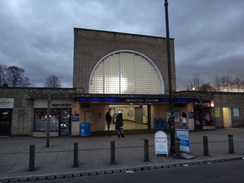
To get to Loughton station, turn left to follow Valley Hill north-northeastwards. After 800 metres a crossroads is reached; turn left along Roding Road. After 450 metres it passes under a rail bridge; on the other side of the bridge, turn left down a path signposted for Loughton station. This curves right and then left, and passes under an archway to reach Loughton station at TQ42309564.
 |
 |
|
Distances
| From | To | Distance (m) | Ascent (ft) | Descent (ft) |
|---|---|---|---|---|
| High Barnet station | Cockfosters station | 4.2 | 361 | 449 |
| Cockfosters station | Enfield Lock | 9.2 | 486 | 728 |
| Enfield Lock | Loughton station | 7.3 | 564 | 551 |
This makes a total distance of 20.7 miles, with 1411 feet of ascent and 1728 feet of descent.
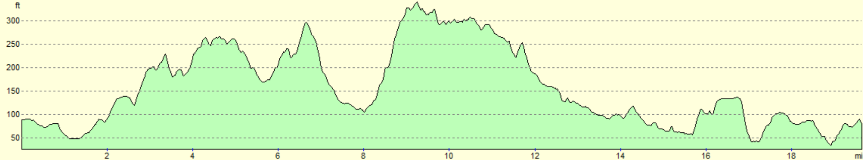
For more information on profiles, ascents and descents, see this page
Transport
The journey between Loughton and North Barnet can be made with one change; take a Central Line train south from Loughton to Bank, and then change to the Northern Line and await a High Barnet train.
 |
 |
|
 |
 |
|
 |
 |
|
 |
 |
|
 |
 |
|
 |
 |
|
 |
 |
|
 |
 |
|
 |
 |
|
 |
 |
|
 |
 |
|
 |
 |
|
 |
 |
|
 |
 |
|
 |
 |
|
 |
 |
|
 |
 |
|
 |
 |
|
 |
 |
|
 |
 |
|
 |
 |
|
 |
 |
|
 |
Disclaimer
Please note that I take no responsibility for anything that may happen when following these directions. If you intend to follow this route, then please use the relevant maps and check the route out before you go out. As always when walking, use common sense and you should be fine.
If you find any information on any of these routes that is inaccurate, or you wish to add anything, then please email me.
All images on this site are © of the author. Any reproduction, retransmissions, or republication of all or part of any document found on this site is expressly prohibited, unless the author has explicitly granted its prior written consent to so reproduce, retransmit, or republish the material. All other rights reserved.
Although this site includes links providing convenient direct access to other Internet sites, I do not endorse, approve, certify or make warranties or representations as to the accuracy of the information on these sites.
And finally, enjoy your walking!
Nearby walks
| # | Title | Walk length (miles) |
|---|---|---|
| 51 | Mile End to Enfield Lock | 12.7 |
| 52 | Enfield Lock to Harlow Town | 12.6 |
| 210 | Rickmansworth to Stanmore via Middlesex's highest point | 9.2 |
|
|

|