Walk #1048: Derby to Nottingham
 |
 |
|
General Data
| Date Walked | 21/02/2020 |
| County | Derbyshire, Nottinghamshire |
| Start Location | Derby railway station |
| End Location | Nottingham station |
| Start time | 07.03 |
| End time | 14.43 |
| Distance | 21.1 miles |
| Description | This was mostly a long road walk east, with only a few sections of footpath. All roads had pavements. |
| Pack | Today I carried my 30-litre Karrimor rucksack, filled with water, my spare waterproofs, a book and other odds and ends. |
| Condition | My legs are fairly tired after this walk, and my knees ache a little after all the running I have done recently. |
| Weather | The day was overcast and cloudy; there were a few brief periods of drizzle, but nothing significant. It was also fairly mild for the time of year, and I got overly warm in my coat and fleece. |
| OS map | Landranger number 128 (Derby & Burton upon Trent) and Landranger number 129 (Nottingham & Loughborough, Melton Mowbray) |
 |
 |
|
Map of the walk
Maps courtesy of Google Maps. Route for indicative purposes only, and may have been plotted after the walk. Please let me have comments on what you think of this new format. For a detailed table of timings for this walk, please see the table file.
 |
 |
|
Notes
It had been a few months since my last walk, and I had to wait six weeks into 2020 for my first of the year. Unfortunately I haven't had a great deal of free time since October, and although I'd kept my fitness up by running every day in January, I was in dire need of a long walk. Half term seemed ideal, so I set off with Robert to my parents' house south of Derby – only to find that the Trent was due to flood, and the water was estimated to reach over a metre above the previous high. Fortunately this turned out to be a software problem and the flood level had been overestimated and did not reach their house – which has never flooded. So Robert and I spent a few days during the bad weather visiting places around Derby – at least those that were open at this time of year.
However I really needed to do a walk, and Friday offered the best weather. The ground underfoot is totally saturated after a few months' of rain, and instead of doing a walk in the Peak District, I decided to chicken out and do one that would follow good paths and roads, eventually settling on walking between Derby and Nottingham. Since there were 40-50MPH winds forecast for the afternoon, I decided to walk from west to east, meaning the prevailing winds would blow me along!
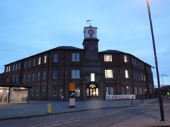
A car park in Pride Park cost a little over six pounds for the day, which was over ten pounds cheaper than the station car park. I have not spent much time in Derby for 25 years, and the change in the area is fantastic. When I was a child, my dad would take me into the locomotive works when he had jobs on. Now all of that has gone, and where hundreds of railway lines once stood, there are now offices and local amenities. Only a few buildings hark back to that earlier history - the roundhouse (the first in the world), which was built in 1839 by Robert Stephenson. Where steam engines once clanked and chuffed, students now talk. The roundhouse is a welcome survivor, and whilst Derby might be better off now the works has been redeveloped, it does feel as though the city has lost part of its soul.
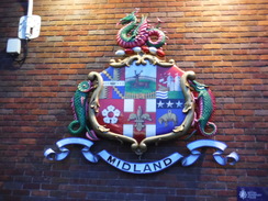
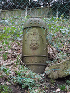
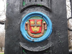
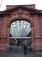
A footbridge took me across the station (no ticket required), and down to the 1980s-built concourse. The area outside the station has improved, and is a much tidier and pleasant place. I stopped off to take a photo of the old Midland Railway coat of arms, which has recently been restored. Trains are still built in Derby a little way south at the Litchurch Lane works (once the carriage works), but that has been taken over in the last few days by Alstom, and it remains to be seen how long the current 175-years of train construction in Derby will continue.
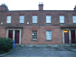
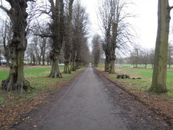
My route was to follow the Derwent east for a few miles, but first I went on a little trip down memory lane. I walked towards the city centre, passing some wonderful railway workers' cottages – again, the first such in the world, and which were saved from demolition in the 1980s. After this, I diverted down Canal Street to visit my dad's old yard. He built the industrial units over thirty years ago, and still owns one side – although not for long, as the entire area is about to be redeveloped. Memories came flooding back as I walked past, and I was amused to find a sandwich shop called Mr Mustards was still going after several decades!
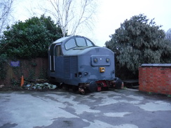
A grey cab from a Class 37 locomotive sat rather forlornly in a pub car park, and I passed this to join the riverside path beside the Derwent, which I would be following for the first couple of miles. Office and amenity buildings now stood where the railway works once was, and soon Pride Park, the home of Derby County Football Club, became visible. It also became audible, as an automated fire alarm called for an evacuation of the ground. This was repeated several times, before another voice announced the end of the test.
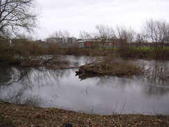
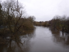
The river was fairly low, although uprooted and low-lying vegetation showed where December's floods had swept past. Some parts of the city centre had got flooded on that occasion, although now the river looked relatively quiescent. It's odd how the Derwent flooded back then, whilst the Trent, just five miles further south, did not to the same scale – and now the Trent has flooded, whilst the Derwent has not. I guess this must just be a symptom of their different catchment areas, with the Derwent's being further northwest of the Trent's.
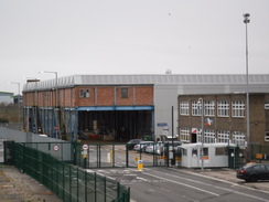
The riverside path took me east, passing under the railway before reaching the bridge that carries Raynesway over the river. I joined the road and followed it north, past the Rolls Royce plant that makes submarine nuclear reactors. Just before the road reached the A52, I headed down the service road and under the dual carriageway to reach Megaloughton Lane. This was another trip down memory lane, as I used to regularly travel down the small and rather untidy road with my dad to the Courtaulds Acetate plant (which he referred to as ‘Celanese') at Spondon. A stink emanated from the nearby sewage works, but soon I was passing a white building (if my memory was correct, it was once the factory shop), and soon the familiar brick factory buildings came into sight.
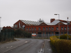
However, there were far fewer of them. The site used to be massive, with a main avenue stretching south, with roads alternating off them – starting at A (possibly Alfreton Road) and then going down to (I think N, for Nottingham Road). The site was set up during the First World War to make acetone dope for plane wings (and, allegedly, more noxious substances). Later on, the world's first synthetic fibre was created in its labs. My brother worked (and helped construct) the C power station which still stands, albeit nonoperational, and I spent a few Easters and summers working for my dad's firm within. Before I was sixteen, my dad would drop me off at the gatehouse, where I would spend many hours chatting to the guards whilst dad was checking on the work. Afterwards, when my health allowed I would work with them – although at times I was probably more of a hindrance than a help. I have many happy memories of working within – from driving dumpers and JCBs to using cutting equipment on demolition jobs.
It was therefore extremely sad to see what has become of the site. The factory mostly closed in 2012, and only a few buildings at the top end remain making Clarifoil, whilst the rest have been cleared. A couple of vast distribution buildings have been created at the site's southern end, and the railway tracks that used to criss-cross the area have all gone. Even the gatehouse had been demolished, replaced with a Portakabin. The railway line here used to be four-track, with a large signal box, and these tracks led to my one and only (so far) driving infringement, when I drove a Landrover pulling a trailer over the lines at slow speed, and got caught out by the police on the other side. The signal box is long gone, as are the two tracks that used to hold Merry-Go-Round HAA coal wagons for the ‘B' power station. Life is about change, but that does not mean change is welcome.
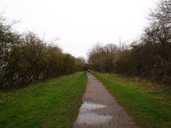
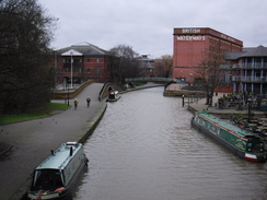
I crossed the station footbridge – which seems overly long now it crosses only two lines instead of four – and joined the route of the old Derby Canal. This part of the canal was engineered by Benjamin Outram, and connected the city with the Erewash Canal. The canal was opened in 1796 and closed in 1964, although there are plans for the route to be reopened. I soon came across the first signs of this – a new housing development, whose frontage will be onto the canal. In fact, the development will be using the renewed stretch of canal as part of its drainage system, so hopefully it's a win-win for both the canal society and the developers.
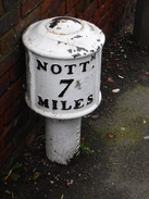
I soon left the canal, and followed a road into Borrowash. There is a firm of bakers in the area called Birds, and I was raised on their pork pies and cakes. I saw a shop near the road, so I nipped in and got a sausage cob and a couple of pork pies to help me through the rest of the day. The cob helped speed me on my way, and I was soon following a road northeastwards out of the village. This passed under the A52 dual carriageway, and there was not much to note aside from a lovely cast-iron milepost and distant views of Hopwell Hall on a hillside to the north.
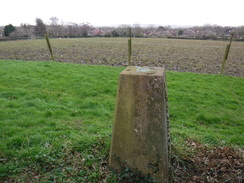
The road led me into the little village of Risley, and after passing the church I headed down a small, pretty lane whose sign contained facts about the lane – a pleasant local touch. This led to fording a stream at a picturesque spot, and then a very muddy climb uphill. My aim was a trig pillar marked on the map, which I eventually found immediately on the other side of the hedge. There was no obvious way over the hedge, and so I just took a few pictures over the twigs and slipped and slid downhill, soon reaching the road once more.
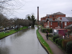
This took me on over the M1 on a bridge, and then down into the town of Sandiacre. The road crossed the Erewash Canal, which is still in use. This canal is twelve miles long, and runs north from the Trent to Langley Mill, where it used to join the Cromford Canal. It opened in 1779 to take coal from mines on the Derbyshire/Nottinghamshire border south to Nottingham and Leicester; the low capacity of the canal was one of the reasons the predecessors to the Midland Railway were formed fifty years later. The canal seems pleasant and well-cared for, and the town seems to like its canal.
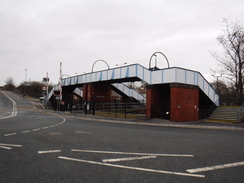
A little later the road crossed the River Erewash, which was crammed between concrete walls and seemed anything but loved. Then came a bridge over the railway line, and to the south I could just make out the throat of Toton yard, a massive railway site and marshaling yard that is still in some use today. The site will be used for a station on HS2, and will hence bring massive changes to the area.
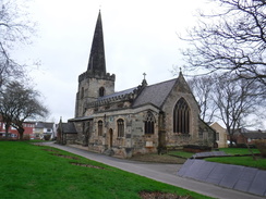
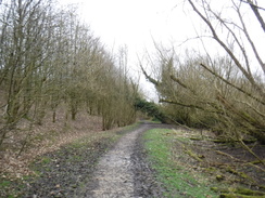
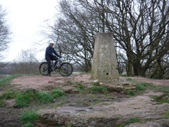
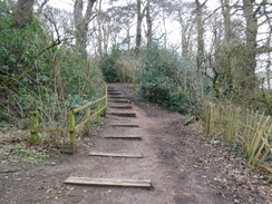
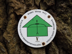
Roads then took me on through Stapleford, passing a stone church that used old slate gravestones as a retaining wall. This was a long and fairly uninteresting stroll, but eventually I left the road to join the Robin Hood Way. This passed through an area of woodland containing trees that had been blown over, an indication of the recent bad weather. Another indication was the muddy field that had to be negotiated to reach a footbridge over a ditch for the long climb up Stapleford Hill. The climb was quite enjoyable, although the Robin Hood Way seemed to skirt the flanks of the hill rather than make for the summit. I left the trail and took a slightly precipitous route up past an old quarry to reach the trig pillar, where a man on a bike was taking in the view. We chatted for a few minutes, after which he zoomed off down what is obviously a well-used bike track.
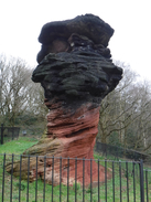
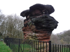
My descent was slower, and soon I was wondering where the trail was. Before I found it, I came across the Hemlock Stone, a massive 8.5-metre tall block of new red sandstone that projects from the surrounding land – apparently, a geological feature called an Inselberg. As I approached I assumed it was a quarrying artefect, but a competing theory says that it is natural – and the debate is raging. The lower portion of the stone is narrower than the top, and the top section is blackened with soot from the industrial revolution. The cleanliness of the rock below shows why it is narrower, as that rock is being eroded by the wind, and eventually the entire stack will fall. In the meantime is is a rather spectacular sight, even behind its mean-looking railings.
The trail descended past the stone to reach a road, and then went through a car park and up a steep ascent to the top of the Bramcote Hills. There were some reasonable views north from here, but soon I was more concerned with routefinding, as there were few trail markers to guide me. I seem to have found the right route down off the hill, and then past a school before walking through the outskirts of Wollaton. Another ascent soon came uphill, although the route marked on the map seemed to end at some posh houses. There was no way through, and so I headed back to the road and, after a little to-and-froing, found a road that led to a path across the summit.
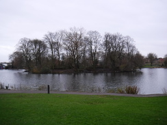
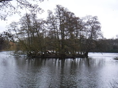
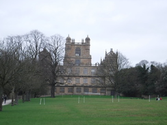
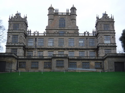
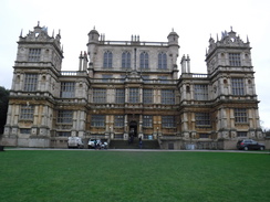
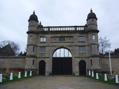
More suburbia followed, and an ascent along roads led to a gateway that led into Wollaton Park. A path took me down to a lake, after which I headed straight up towards the imposing hall, along with its equally imposing stable block. Wollaton Hall was built in the 1580s, and was eventually bought by Nottingham Council in 1925 and made into a museum – hence saving it from the fate that sadly faced so many large country houses in the mid-twentieth century. It is a spectacular house, with a classic Elizabethan frontage that must offer commanding views over the city that has enveloped it.
I headed away from the hall along Lime Tree Avenue; I am no arborist, so I can only assume that the trees that lined the long avenue were limes. They ended at a gate that dumped me onto a busy dual carriageway, and from there I joined roads past a rather spectacular Gatehouse Lodge (presumably the city has grown up around the park's original exit), and the University of Nottingham's Jubilee Campus into the suburb of Lenton.
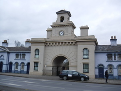
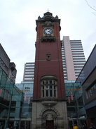
More road walking followed up into Nottingham; as there was still time and the promised high winds had not developed, I took a slightly indirect route, heading to the Victoria Centre and its large clock tower (the only remnant of the old Victoria station), and then headed along familiar roads down to the railway station. At least, they were sort of familiar: the addition of trams down some roads was a welcome change. I like Nottingham, and it certainly seemed to be more bustling and lively than Derby had been earlier in the week.
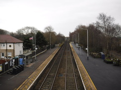
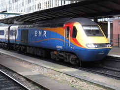
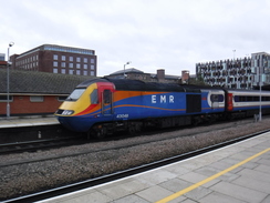
I got to the station, purchased a ticket and went down to the platforms, where an HST was waiting. These classic trains are slowly going out of service after nearly fifty years of service, and it was good to see another one – even if their current livery isn't the best. I got on my train, only for a last-minute platform change to send me scurrying to a different one – despite the platform indicators by the original train showing Derby as its destination. Fortunately it did not cause me any delay, and I was soon whizzing back to Derby.
It had not been a classic walk, although the roads had been safe and there had been some very enjoyable stretches. It had been a reasonable start to what will be a sparse 2020 walking campaign.
 |
 |
|
Directions
This walk starts off from Derby railway station at SK36173556. Leave the station by the main concourse, and angle right past the bike sheds to reach Railway Terrace. Cross this using the pedestrian crossing, and head straight on along Midland Place. As this turns right, veer left up a short path called Francis Thompson Walk that leads out onto Park Street. Turn right along this for a few metres, and then right down Canal Street. When this ends, turn right along Siddals Road for a few metres until Railway Terrace is rejoined beside the Alexandra pub. Cross the road using the pedestrian crossing, and on the other side turn left to head under a large bridge at SK36133590.
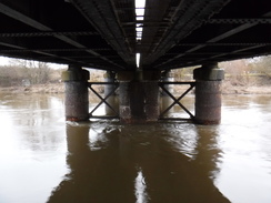
Under the bridge, descend a path that slopes towards a large brick railway bridge over the Derwent (the Five Arches bridge), and then turn right to join a cycle path, with the river on the left. This immediately passes under the bridge, and continues on alongside the river. It passes under a road bridge and then a rail bridge, before passing Alvaston Park. After 3.4km the path reaches the A5111 Raynesway at SK38403423.
When the path forks immediately before the bridge, take the right-hand branch that leads up to the road, and then turn left to follow the road north, with the road on the right. After 1.1km the road starts to climb up onto an overpass at SK38703522.
Just before the start of the climb, turn left along a stub road towards (in 2020) Bestway Cash and Carry, and then right to join the West Service Road, which soon curves right to head under Raynesway, becoming the East Service Road. It soon passes an ambulance station; immediately after this, turn left along Megaloughton Lane. Follow this as it heads east, passing a sewage works. After 800 metres it reaches a road junction by a level crossing at SK39683511, with the old Courtaulds Acetate / British Celanese site off to the right.
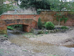
Turn left to cross the railway, either by the level crossing or adjacent footbridge. Immediately on the other side the road starts to climb up towards a canal bridge; angle right to join a path that meets the towpath of the old canal beside the bridge. Turn right to head eastwards, along the towpath, which is now a footpath. After about a kilometre a new housing development is reached, along with a stretch of watered canal; pass this, and at the far end angle left along a surfaced path that passes an electricity pylon and a children's playground to reach a squeeze-stile that leads out onto the A6005 at SK41113480.
Turn right to follow the road east; there is a pavement on the other side of the road. It soon enters Borrowash; follow the road through the village, and after about 720 metres it curves to the left. Ignore the A6005 junction off to the right, and continue straight on in a rough east-northeasterly direction along the B5010, which soon leaves the village. Continue along this road; it passes under the A52, and 4.4km after the road junction in Borrowash, it reaches Risley Church on the left at SK46103565.
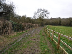
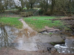
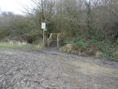
Pass the church and an adjacent grand house, and then turn left down a surfaced lane called The City. This heads north, following a stream on the left; it crosses the stream, and after about 200 metres it reaches a gate leading into a nature reserve. Cross a stile beside the gate, and turn right down some steps to join a short path that fords a stream and crosses a footbridge. On the other side, climb some steps to reach a pedestrian gate. Go through this, and start uphill along a green lane, with a hedge on the right and fence on the left. The path then descends to a pedestrian gate beside a field gate; go through to reach a lane; turn right along this and follow it for 230 metres until it ends back art the B5010 at SK46523581.
Turn left to continue following the road eastwards; it crosses over the M1 on a bridge, and then descends down into Sandiacre, reaching a complex junction in front of the Erewash Canal after 1.6km. Carefully cross the road coming in from the left using the pedestrian crossing, and then continue along the B5010 as it crosses a bridge over the canal. The road soon crosses the culverted River Erewash, and then climbs to cross a railway line. On the other side of the rail bridge, the road curves to head northeastwards through Stapleford, and 1.4km after the canal, it reaches a junction at SK48863715.
At the junction, turn left to head north up Church Street. After 500 metres it becomes the B6003 Pasture Road; continue north along this for another kilometre until it ends at a roundabout with the A6007. Turn slightly left to follow the A6007 north; there is a pavement on the left. Just before houses start on the right after 330 metres, carefully cross the road and head down Pit Lane. After 340 metres this ends at a little car park at SK49203910.
Head straight across the car park, and on the far side go through a clappergate to enter an area of parkland. Immediately turn right to start following a hedge on the right downhill; after 270 metres the path turns sharply left, with a brook away to the right. Ignore a path coming in from the left, and continue along a good path through trees. After another 360 metres it emerges into a field. Turn right to follow the edge of the field on the right; this leads to a footbridge over the stream on the right at SK49713900.
Cross the footbridge and continue heading south along a path that soon starts to climb. Take a steep path that heads directly up the hill, and carefully make your way to the trig pillar at the summit. Once there, carefully head downhill to the southeast, passing the Hemlock Stone to reach the A6002. Turn right down the road, and just before a roundabout is reached, turn right to carefully cross the road using a pedestrian crossing to reach a path that leads into a car park at SK49943847.
Cross the entrance road to a car park on the left, and head toward a children's play area. Just before the play area, turn left into Bramcote Hills Park. Ignore a good path leading off to the right, and instead ascend three sets of wooden steps up the hill. At the top, the path winds around past a steep drop on the left, which is guarded by a fence. As the fence suddenly angles left, follow a rough path down beside the path. At the bottom of the slope, pass a clappergate on the left (do not go through it) and join the path leading out of the gate, with a fence and hedge on the left. Soon after, turn left sown a path that runs beside a pallisade fence guarding a school on the right. This path ends at a T-junction with a broader path; turn right to follow this east for 180 metres until it ends at a T-junction with Moor Lane at SK50723881.
Turn left to head north up the lane for a few metres, and then right to join another footpath that passes a vehicle barrier to head east. After about 400 metres the path merges with Eastcote Avenue; continue straight on along this. Immediately before the first house on the right, turn right down a footpath that finishes after a short distance at Thoresby Road at SK51413875.
Cross the road, and on the other side continue straight on along a path. This soon curves left, and just before it reaches the end of a road, turn right along another path. This slowly curves right, becomes surfaced and climbs uphill, before ending at the end of Sandy Lane at SK51533854.
Continue straight along Sandy Lane, and take the first road off to the left, Markham Road. As this road starts to curve right, angle left along a surfaced footpath that climbs into trees. It soon emerges into a clearing, with a children's play area on the left; it soon re-enters the trees and starts falling. When it meets a surfaced path coming in from the right about 240 metres after the clearing, turn left down this path. Steps lead down, and a path continues down before emerging out onto the end of Kingsdown Mount at SK52073856.
Turn left along the road, and then take the first road off to the right, which soon ends at a junction with Appledore Avenue. Turn left along this; it immediately curves left. After the bend, turn right down Vines Cross, which soon ends at a T-junction with Woodbank Drive. Turn right along this, and follow it for 180 metres until it ends at a T-junction with Wollaton Vale. Carefully cross the road, and turn left, and then take the first road off to the right, Wollaton Rise. Follow this uphill until it ends at a T-junction with Parkside; turn left along this for a few metres, and then turn right to reach some gates at the entrance to Wollaton Park at SK52353889.
There is a small pedestrian gate to the right of the main gates; go through this, and head along past another couple of gates to enter Wollaton Park. Head straight on down a tree-lined avenue, which soon reaches the northern end of a lake. At the lake turn slightly left, cross a footbridge over a ha-ha, and head straight uphill towards Wollaton Hall. Pass the stables block on the left, and then ascend a grassy slope towards the main house. Ascend some steps on the left-hand side of the building; at the top turn left to a little archway and then right to reach the house's forecourt at SK53163926.
Keep the house on the right and join its access road, which descends, When it soon forks, take the right-hand branch that heads down a slope and curves right, becoming Lime Tree Avenue. This curves right and then slightly left, taking a rough easterly course past a golf course. Nearly a kilometre after the hall, go through a pedestrian gate beside a gateway to continue along the avenue; it emerges through another gateway onto the A6514 Middleton Boulevard at SK54453912.
Turn left to follow the road north for a short distance until a pedestrian crossing is reached on the right; use this to cross the road, and then head straight on down Charnock Avenue. After 300 metres this ends at a little turning circle; angle right past bollards to follow a cycle path for 100 metres until it ends at the A6200 Derby road beside the Gatehouse Lodge at SK54873917.
Turn left to follow the road northeastwards towards the centre of Nottingham. After 2km a complex road junction is reached in front of the Nottingham General Cemetery. As the road swings right to join Alfreton Road at a complex junction, turn left to cross the roads via the pedestrian crossing, to reach near to the imposing gateway leading into the cemetery at SK56434015.
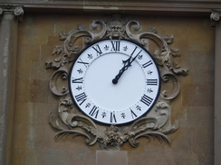
Turn right away from the gateway, following Talbot Street as it curves left. Continue along the road as it slowly descends eastwards. When it ends at a junction, cross the road ahead and head straight on along Burton Street. When this ends at a T-junction with Milton Street, cross the road ahead and turn left to reach the Victoria clock tower on the right at SK57294030.
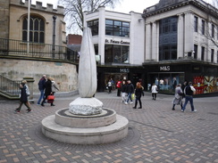
Turn right to pass the clock tower and enter the Victoria shopping centre. Once inside, take the first right to start heading south past the shops. Leave the centre via its southern exit onto Lower Parliament Street, and head straight on down Clumber Street, which soon becomes High Street. When this soon ends, turn left and then immediately right down Bridlesmith Gate, and then take the first road off to the right, St Peter's Gate. This soon reaches a junction with Albert Street in front of St Peter's church at SK57263976.
Turn left to follow Albert Street southwards downhill; it soon curves gently right and becomes Lister Gate before reaching the Broadmarsh shopping centre. Enter this, and head straight on to reach the exit onto Collin Street. Turn left for a few metres to reach a pedestrian crossing, and use this to cross the road. On the other side, head straight on up Carrington Street. Cross Canal Street, and continue along Carrington Street as it soon crosses the canal. Nottingham railway station is a short distance away on the left at SK57403921.
 |
 |
|
Distances
| From | To | Distance (m) | Ascent (ft) | Descent (ft) |
|---|---|---|---|---|
| Derby station | Borrowash | 5.6 | 78 | 77 |
| Borrowash | Stapleford | 5.7 | 213 | 224 |
| Stapleford | Wollaton Hall | 5.5 | 546 | 492 |
| Wollaton Hall | Nottingham station | 4.3 | 221 | 332 |
This makes a total distance of 21.1 miles, with 1058 feet of ascent and 1125 feet of descent.
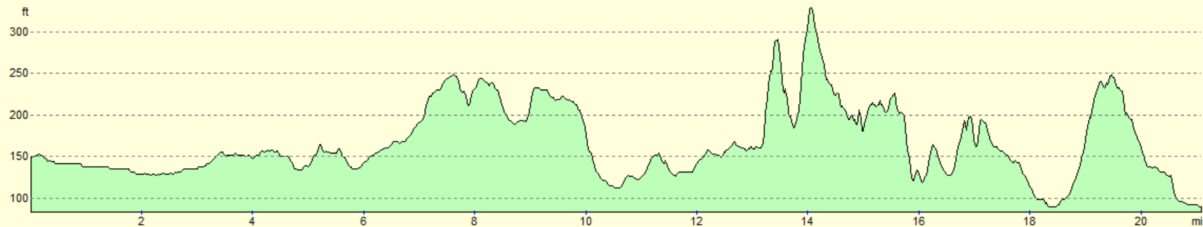
For more information on profiles, ascents and descents, see this page
Transport
There are regular train services between Nottingham and Derby; see the National Rail Enquiries website for more details.
 |
 |
|
 |
 |
|
 |
 |
|
 |
|
|
 |
 |
|
 |
 |
|
 |
 |
|
 |
 |
|
 |
 |
|
 |
 |
|
 |
 |
|
 |
 |
|
 |
 |
|
 |
 |
|
 |
 |
|
 |
 |
|
 |
 |
|
 |
 |
|
 |
 |
|
 |
 |
|
 |
Disclaimer
Please note that I take no responsibility for anything that may happen when following these directions. If you intend to follow this route, then please use the relevant maps and check the route out before you go out. As always when walking, use common sense and you should be fine.
If you find any information on any of these routes that is inaccurate, or you wish to add anything, then please email me.
All images on this site are © of the author. Any reproduction, retransmissions, or republication of all or part of any document found on this site is expressly prohibited, unless the author has explicitly granted its prior written consent to so reproduce, retransmit, or republish the material. All other rights reserved.
Although this site includes links providing convenient direct access to other Internet sites, I do not endorse, approve, certify or make warranties or representations as to the accuracy of the information on these sites.
And finally, enjoy your walking!
Nearby walks
| # | Title | Walk length (miles) |
|---|---|---|
| 64 | Long Eaton to Willington | 14.0 |
| 68 | Willington to Doveridge | 12.6 |
| 76 | Bingham to Nottingham | 13.5 |
|
|

|