Walk #1046: Wigan to Widnes
 |
 |
|
General Data
| Date Walked | 22/10/2019 |
| County | Merseyside, Cheshire, Greater Manchester |
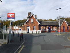
| Start Location | Wigan North Western station |
| End Location | Widnes station |
| Start time | 07.46 |
| End time | 15.34 |
| Distance | 21.8 miles |
| Description | This walk was mostly along roads, although a pleasant stretch of footpath took me to the top of Billinge Hill, Merseyside’s highest point. Unfortunately I could not reach my target of Runcorn, as the bridge across the Mersey was closed. |
| Pack | Today I carried my 30-litre Karrimor rucksack, filled with water, my spare waterproofs, a book and other odds and ends. |
| Condition | I feel absolutely fine after this walk. |
| Weather | Today was dry and fine; perfect autumnal weather for a stroll. |
| OS map | Landranger number 108 (Liverpool, Southport & Wigan) |
 |
 |
|
Map of the walk
Maps courtesy of Google Maps. Route for indicative purposes only, and may have been plotted after the walk. Please let me have comments on what you think of this new format. For a detailed table of timings for this walk, please see the table file.
 |
 |
|
Notes
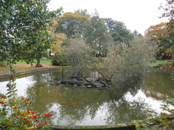
I had a good breakfast at the hotel, and then headed off for the short drive into Wigan, parking in exactly the same spot I did on Sunday. The town had seemed a very depressed place on that Sunday morning, but at the same time on a Tuesday it seemed much livelier and pleasant, with shops open and lit, and more people strolling about. My initial impressions may not have been wrong, but they were not the whole story.
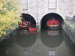
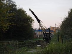
I diverted off the road to have a look at the canal at Wigan Pier, and saw a building that had two narrow boats moored under it. A little further on railings protected an overgrown space complete with information boards, an old crane and what looked like a maintenance boat that had been lifted onto dry land. I could see no way of getting into the area, and the general feeling of dilapidation made it look as few people tried.
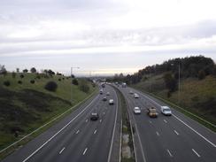
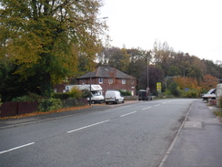
A complex road junction followed, where I had to pick the middle of three roads heading south. Initially I picked the wrong one, before cutting across a side street to reach the correct one. This took me slowly uphill to a bridge over the motorway, after which a busy side road - thankfully with pavement - paralleled the motorway. Another road - this one without pavement - took me south downhill into the village of Longshaw. The descent offered some views of masts and a squat building on the skyline ahead, marking Billinge Hill, my next target.
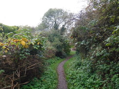
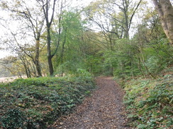
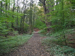
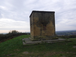
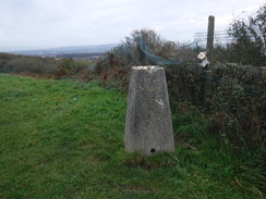
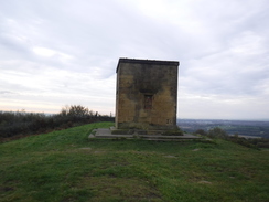
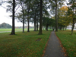
The day’s only stretch of footpath followed, as a path skirted houses and then climbed through an area of woodland. Perhaps it was the fact I had been following canals for the last couple of days, but this autumnal woodland walk felt superb, and I enjoyed every step. Eventually the path reached a gate that led out of the trees, and it continued climbing past an area of bracken to reach a squat stone building on top of Billinge Hill, Merseyside’s highest point.
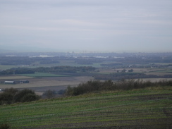
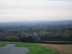
The summit offered superb views, with a vast area visible despite the summit’s relatively low height and the grey weather. The sun was low over the Pennines to the east, and the sea was just about visible to the west. I could just about see the Runcorn Bridge - my end target for the day - and apparently Snowdon is visible on clear days. It is a superb spot, which even the nearby aerials do not spoil.
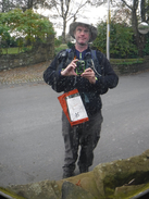
I was not the only one to think so, as I was not alone. A man had a small fire going, and he told me that he regularly came up here to watch the sun rise and set. He showed me a video of the spectacular sun rise that morning, and also of him playing the guitar. We chatted for ten minutes, before with some regret I bade him goodbye and headed south down the hill.
The rest of the day was to be along roads, and the first stretch took me through Billinge and along a main road into Clinkham Wood. I followed local roads through a housing estate, and then a main road into St Helens. In the centre of the town, I nipped into a shopping centre to find the toilets, and ended up walking a long way through it and into another before I found them. On the way back, I found some very near the entrance I had entered - another few hundred metres added onto the walk for no reason! A man handing out leaflets referred to me as Crocodile Dundee, perhaps because of my Tilley Hat.
I headed out of the centre, and followed a dual carriageway southeastwards. This proved to be a mistake, as the pavement ended at a railway overbridge and I had to walk in the road for fifty metres. I tried to time this for a gap in the traffic, but did not quite make it to the verge on the other side before the first cars rushed past. From the state of the verge, I am not the only person who has taken this rather dangerous route. Worse, a quick look at the map once I got home showed there was a rather better route available to the north.
A pavement restarted after the next roundabout, which took me past St Helens rugby stadium. Wigan also has a rugby stadium, so the two adjacent towns have large stadiums very close to each other. Dual carriageways took me south, and I swapped sides to the western side of the road to walk alongside Sherdley Park. My throat was starting to feel a little rough, and I put this down to all the traffic fumes that hung in the air.
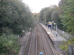
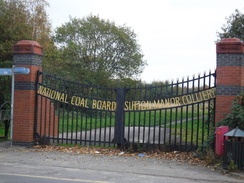
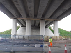
I passed Lea Green station and followed another road south, passing a country park that was once one of the many collieries that gave the area its historic wealth and deprivation. Fortunately pavements continued along the road over the M62 and A557 roads all the way into Widnes. There was not much of note in the town as I passed its station and contined south. The first real note of interest was the new Mersey Gateway Crossing, a bridge that has just opened to relieve the stress on the old, magnificent arched Runcorn Bridge.
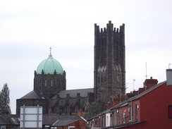
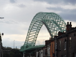
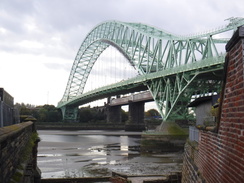
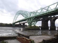
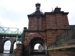
Roadworks for the new bridge were still ongoing, but did not affect my route as I followed local roads south towards the graceful (if dominating) green arch of the Silver Jubilee Bridge. There were some magnificent views of the bridge over the rooftops as I approached, and as I had time I went right down into the oozy mud at the riverfront, where I realised an arch was part of the abutment for the old transport bridge that once spanned the river. I looked around the area a little, and found a building that had a plaque proclaiming ‘Transporter Bridge Office’ on it. It’s good that a reminder of that piece of history still remains, in the form of the abutment and the offices.
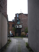
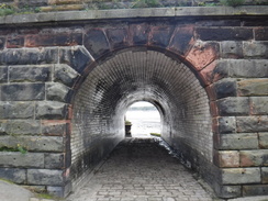
The opening of the new crossing allowed the temporary closure of the old bridge for refurbishment. My map stated it was due to reopen in early 2019, but research had told me that the project had suffered severe delays. However I believed it had been due to open for pedestrians in the summer, so I walked under the bridge (and hence connected today's walk up with my coastal walk), and tried to reach the bridge. The footpath on one side was blocked off, so I walked through one of the dankest and dingiest underpasses I can remember to reach the other side, where a sign told me that the bridge was open to pedestrians - but only after four in the afternoon.
Not wanting to wait around for over an hour, and having reached my two main objectives for the day, I decided to walk back to Widnes station, from where I could get a train to Liverpool and then Wigan. The walk flew by, and whilst I’d expected to be annoyed by this diversion, I didn’t particularly mind. It was annoying not to have been able to cross the bridge, but I was feeling fine, and had a few more miles left in me when I finally reached the station.
Today had involved many miles of road walking, but I had enjoyed it nonetheless. The highlight had to be Billinge Hill, with an honourable mention reserved for the remains of the old transporter bridge by the riverfront in Widnes.
 |
 |
|
Directions
This walk starts off at Wigan North Western railway station at SD58140541. Leave the station by its main entrance onto Wallgate, and carefully cross over to the right-hand side of the road. Turn left to follow the road downhill, almost immediately passing under a rail bridge. The road ends under the bridge at a bend in another road; head straight on down Wallgate, keeping the road to the left. Continue along the road as it becomes a one-way road and passes an old stone canal warehouse on the left. It parallels the canal and Wigan Pier on the left, before curving left to cross the canal on a road bridge. This then passes under a railway bridge to reach a large and complex roundabout at SD57190520.
This roundabout was slightly confusing; head straight on, keeping the main body of the roundabout to the right, crossing the A49 Southgate, which comes in from the left. Continue along the road as it leaves the roundabout, and then turn right to cross the road to reach the Queens Arms. Continue on along a road called the A571 Victoria Road, which angles off slightly to the right. Follow this road as it heads southwestwards, passing Victoria Park on the left and starting to climb. It passes Pemberton station, and 4.3 km after the roundabout, it crosses the M6. Cross over to the right-hand side of the road, and shortly after the motorway bridge, the road ends at a T-junction at SD54370192.
Turn right along Winstanley Road, which parallels the motorway off to the right northwestwards; there is a pavement on the right. When the road curves slightly to the right after nearly 700 metres, turn left along Park Road. This is narrow and has no pavement, so take care. The road curves around and descends westwards to enter the village of Longshaw; after 1km it ends at a T-junction with the B5206 Upholland Road at SD53050225.
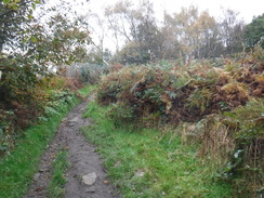
Carefully cross the road ahead, and then turn left for a few metres and then right past a field gate to join a surfaced footpath. This runs past the backs of houses on the right and a pond on the left; the houses end and an unsurfaced path continues on. Go through a clappergate beside a field gate to enter Billinge Wood. Follow the obvious path as it climbs through the trees; when it forks, take the left-hand branch that continues to climb to the south, soon curving right to skirt a fence off to the left. When another path is met at the top of the slope, turn left through a gap in a fence and follow the path as it climbs through some bracken to reach a grassy area. Ascend this for a short distance to reach the folly and trig pillar on the summit of Billinge Hill at SD52560142.
Once you have visited the summit, return downhill north the way you came, and at the edge of the grassland turn left to start following a path along the flank of the hill, with the summit to the left and a field boundary to the right. Go through a couple of old clappergates as the path becomes surfaced and heads downhill until it ends at a surfaced track. Turn right along this; it soon curves sharply to the left to start heading south downhill. It approaches Crookhurst Farm; go past a double gate and continue along the track as it curves right, continuing to descend. 1.2km after joining the track, it ends at a T-junction with the B5025 road at SD52430017.
Carefully cross the main road to reach the pavement on the other side, and then turn left to follow it southeastwards into Billinge. A roundabout is reached after 400 metres; turn right down the A571 Birchley Road. This heads downhill southwestwards out of Billinge; it crosses a stream on a bridge, and then starts to climb, slowly curving to the left as it does so into Clinkham Wood. Ignore the first road off to the right, and 1.8km after joining the road and on the left-hand bend, turn right down Broad Lane at SJ52059851 to enter a housing estate.
After a few metres turn left down Dunmail Avenue, and follow this as it curves left and then right past houses and a school. It then curves left past a skate park and a little childrens' play area; turn right down Honister Avenue. When this ends at a T-junction with Bowness Avenue, cross the road ahead and head straight on down Kendal Drive. This soon curves around to the left; as it does so, turn right into a little car-parking area, and then left down a surfaced path that heads between houses, going through a gap in a fence to reach a T-junction with another surfaced path, with an area of grass ahead. Turn right along this path, and after a short distance turn left down another path that soon ends at the A580 dual carriageway at SJ51899753.
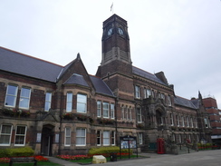
Use the pedestrian crossing to cross the dual carriageway, and on the other side head straight on down Green Leach Lane. After 550 metres a roundabout is reached; continue on along the A571 with Haresfinch Park to the left, to another roundabout. Here turn right to head south along Haresfinch Road. This passes under a railway bridge, and 1.4km after the mini-roundabout, it reaches a mini-roundabout in the centre of St Helens. Turn left along Corporation Street, which soon reaches a plaza in front of St Helens Town Hall at SJ51229550.
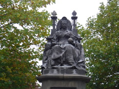
On the plaza, immediately turn right to pass a statue of Queen Victoria and head down Cotham Street. Cross Claughton Street ahead, and continue down Cotham Street until it ends. Turn left down Omskirk Street, and follow this as it soon curves right to become Bridge Street, passing the Church Square shopping centre on the left to end at a roundabout. Head staight on along Chalon Way West for a short distance, passing a McDonalds on the left, to reach the dual carriageway A58 at SJ50939513.
(Note, the following route was slightly dangerous. Perhaps try to find an alternative through the south of St Helens.) Turn left to walk east-southeastwards along the A58. Initially there is a pavement on the left, but this ends at a rail overbridge. Carefully squeeze along the road past the bridge abutment, when a grass verge starts. 600 metres after joining the road, it ends at a roundabout. Cross the road coming in from the left and continue south along St Helens Linkway. At a roundabout, cross the entrance to a Tesco store on the left, with the St Helens rugby stadium behind it, to reach a larger roundabout at SJ51639416.
Continue southeastwards along Scorecross, which ends after 600 metres at another roundabout. Cross the road coming in from the left, and turn right to follow a dual carriageway (Marshalls Cross Road) south. When you can, safely cross over to the right-hand side of the road, where a more pleasant path runs between the dual carriageway and Sherdley Park. 1km after the roundabout, cross Elton Head road and continue on for a few metres to reach a bridge over a railway line in front of Lea Green railway station at SJ51949247.
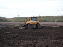
Continue from the bridge for a couple of metres to reach a roundabout; pass in front of the Bull and Dog pub on the right, and take the first exit to the right, the B5419 Chester Lane. Follow this road as it heads south; it passes through Sutton Manor and past the landscaped site of its eponymous coal mine, before crossing the M62. 3km after the roundabout, the road meets a crossroads with the A57. If you are on the right-hand side of the road, then there is no pedestrian crossing; there are on the other three limbs of the crossroads. Whether you risk crossing the road ahead or go around the other three crossings, continue south along the road. After another 1.2km it meets the A5080 Lunt's Heath road at SJ51158837.
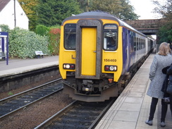
Turn right to head west along Lunt's Heath road, and when a roundabout is reached after a short distance, turn left along the B5419, passing Birchfield Gardens on the left. Follow this road as it heads south into Widnes; after 1.3km it crosses a bridge over the railway line ifn front of Widnes station at SJ51328710. (Note: you can end the walk here if you want; what follows is a to-and-back walk down to the Mersey and the Runcorn Bridge.)
Continue south along the road as it heads through Widnes; after 1.8km it ends at a roundabout beside Widnes library. Cross the road coming in from the left, and continue srtaight on down Victoria Road. This curves to the left and after 250 metres reaches the A562 Ashley Way. Carefully cross this, and continue south along Victoria Road. This passes under a railway bridge and then a new (2019) bridge carrying the northern approach road to the Mersey Gateway Bridge at SJ51208475.
Pass under the bridge, and continue on for a few metres to a roundabout. Head straight on to continue down Waterloo Road. As this curves right, turn left down Upper Mersey road. This heads south, passing the Catalyst museum on the left and becomes Mersey Road. Continue on south along this road past terraced housing until The Mersey pub is reached on the right at SJ51118370, beside the abutment of the old transporter bridge.
From here, turn back along Mersey Road, and then take the first road off to the left, Parsonage Road. This passes under the approach viaduct to the Silver Jubilee Bridge; immediately afterwards, turn right up a surfaced path that parallels the viaduct on the right. Soon afterwards, turn right through an underpass; on the other (eastern) side of the road, climbs steps to reach the end of Irwell Street at SJ51078393.
From here you have a choice; you can either climb more steps to reach the Silver Jubilee Bridge, which will take you over the Mersey to Runcorn, from where you can catch a train back to Liverpool and then Wigan. However the bridge was closed when I walked this in 2019, so I headed down Irwell Street to reach Mersey Road, and then turned left to retrace my steps for 3.3km back north to Widnes Station.
 |
 |
|
Distances
| From | To | Distance (m) | Ascent (ft) | Descent (ft) |
|---|---|---|---|---|
| Wigan North Western station | Billinge Hill | 5.5 | 636 | 174 |
| Billinge Hill | St Helens | 5.3 | 115 | 617 |
| St Helens | Widnes | 6.2 | 174 | 144 |
| Widnes | Silver Jubilee Bridge | 2.3 | 46 | 148 |
| Silver Jubilee Bridge | Widnes station | 2.5 | 135 | 46 |
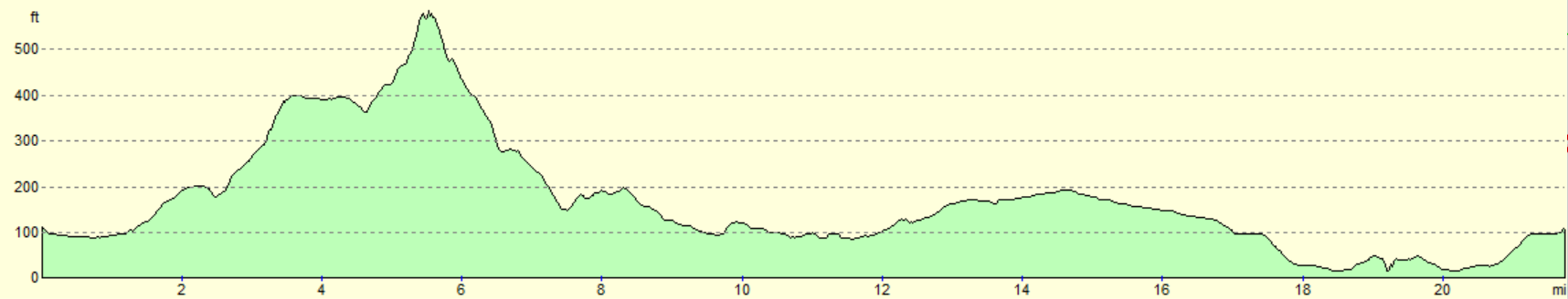
This makes a total distance of 21.8 miles, with 1106 feet of ascent and 1129 feet of descent.
For more information on profiles, ascents and descents, see this page
Accommodation
I spent the night at the Holiday Inn Express in Wigan. This was a pleasant place to spend the night, with the added bonus of a very early breakfast, allowing me to get out of the door and walking at first light. It is not as characerful as a B&B, or as cheap as camping, but it is comfortable, clean and does what it does well.
Transport
There are no direct trains between Widnes and Wigan; instead, you need to travel into Liverpool Lime Street and change for a Wigan train there. Fortunately the services are regular on both lines. At the time of writing (2019), avoid travelling via Crewe, which is much more expensive. See the National Rail Enquiries website for more information.
 |
 |
|
 |
 |
|
 |
 |
|
 |
 |
|
 |
 |
|
 |
 |
|
 |
 |
|
 |
 |
|
 |
 |
|
 |
 |
|
 |
 |
|
 |
 |
|
 |
 |
|
 |
 |
|
 |
 |
|
Disclaimer
Please note that I take no responsibility for anything that may happen when following these directions. If you intend to follow this route, then please use the relevant maps and check the route out before you go out. As always when walking, use common sense and you should be fine.
If you find any information on any of these routes that is inaccurate, or you wish to add anything, then please email me.
All images on this site are © of the author. Any reproduction, retransmissions, or republication of all or part of any document found on this site is expressly prohibited, unless the author has explicitly granted its prior written consent to so reproduce, retransmit, or republish the material. All other rights reserved.
Although this site includes links providing convenient direct access to other Internet sites, I do not endorse, approve, certify or make warranties or representations as to the accuracy of the information on these sites.
And finally, enjoy your walking!
Nearby walks
| # | Title | Walk length (miles) |
|---|---|---|
| 419 | Ellesmere Port to Hale | 20.5 |
| 420 | Hale to Crosby | 19.5 |
| 1038 | Leeds and Liverpool Canal: Cherry Tree to Wigan | 20.2 |
|
|

|