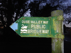
Walk #979: Ouse Valley Way: Harrold to Bedford
 |
 |
|
General Data
| Date Walked | 19/01/2018 |
| County | Bedfordshire |
| Start Location | Harrold country park |
| End Location | Bedford Prebend Street car park |
| Start time | 07.48 |
| End time | 14.38 |
| Distance | 19.4 miles |
| Description | This was a pleasnt walk following the Great Ouse as it winds its way southeastwards towards Bedford. |
| Pack | Today I carried my 30-litre Karrimor rucksack, filled with water, my waterproofs, a book and other odds and ends. |
| Condition | I feel absolutely fine after this walk. |
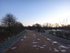
| Weather | Today started very cold, with ice underfoot, and cloudless skies overhead. As the day progressed the clouds started to gather, and it never really warmed up. |
| OS map | Landranger number 153 (Bedford & Huntingdon, St Neots & Biggleswade) |
 |
 |
|
Map of the walk
Maps courtesy of Google Maps. Route for indicative purposes only, and may have been plotted after the walk. Please let me have comments on what you think of this new format. For a detailed table of timings for this walk, please see the table file.
 |
 |
|
Notes
I had wanted to do this walk for a couple of months, and printed its maps out before Christmas. Life, weather and general laziness intervened, and it was only today that I got around to doing it. One of the few bus services from Bedford to Harrold was due to depart at 07.15, so at 06.00 I set off for the drive to Bedford, leaving plenty of slack time. This went well until I reached the centre of Bedford, where a couple of roads were closed by the police, blocking my route to a car park near the bus station. A car park at a hotel near the castle mound cost ten pounds for the day, so I drove around increasingly manically until I found a car park on Prebend Street.
Half an hour of my slack time had been lost during this stupidity, and I had just twenty minutes to reach the bus station. This was easily doable, so I quickly got my boots on and set off. I knew the route, but as I was a little pushed for time I decided to take what I laughably thought would be a 'short cut'. Unfortunately the road I chose, Rutland Road, looped around and ended up on the road I started on, except further away from my destination! Appalled with my lack of judgement I started running, which is never a pleasant experience in my walking boots. My anger with myself and with Bedford's lack of signage only abated when I reached the bus station with three minutes to spare. The bus had not yet arrived, and I decided to risk going into Greggs to buy a couple of sausage rolls for the trip. The bus still hadn't arrived by the time I got back, and I smiled at having snatched victory from the jaws of defeat.
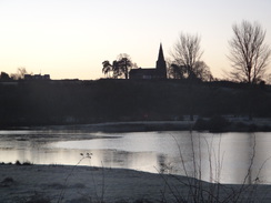
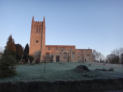
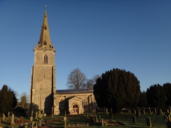
Dawn had not yet quite woken when the bus dropped me off at the entrance to Harrold Country Park. The sun was rising behind a church on a ridge to my right, a warming view on a bitterly cold morning. Shards of ice lay like broken glass near puddles, and patches of frost whitened the amber path. It was one of those mornings when it was best just to keep moving, and I savoured the residual warmth from the sausage rolls as I munched them. Soon I was leaving the park and entering the small hamlet of Odell. A little road walking took me on to Odell church, which shone a magnificent ruddy red from the rising sun.
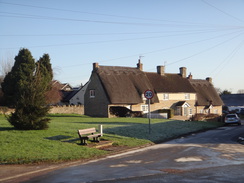
The road leading uphill from the church was slippery with ice, and I had to shuffle on to the verge a couple of times as cars passed me on the narrow road. It was a relief to get off tarmac and on to a path that ran across fields to some woodland, with the frozen mud cracking under my boots. A road then led on into the village of Sharnbrook, where an impressive gateway flanked by lodges stood beside the road. The centre of the village was bustling as mothers took their children to school, and the traffic and the low sun made any decent photography impossible. I nipped into a shop to buy some snacks and headed off out of the village.
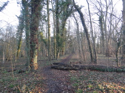
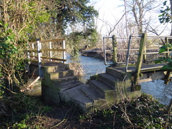
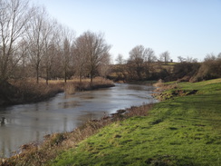
A windmill marked on the map proved to be little more than a stump sitting in a garden. Several bridges took me over the river, the first time the trail had encountered the river so far today. I had thought the bridges had been replaced last year, but there was little sign of any modernisation. The recent storms had deposited leaves, twigs and branches over the area, and it all seemed a little grey and neglected. Two of the bridges were arranged in a V, with the steps down from one leading immediately to the steps leading up onto the other - an unusual arrangement that proved difficult to get a good photo of. A fairly nondescript stretch of path followed, heading uphill from the river across fields to the village of Radwell.
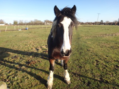
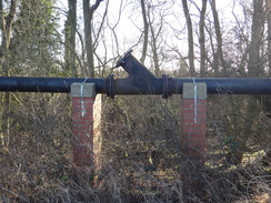
Perhaps it was the sunny weather, but I felt like every village I passed through appeared picturesque. Thatch sat atop yellow-stone walls, and every church looked perfectly formed. A path led out of Radwell across a series of paddocks, and an inquisitive horse came to say a friendly hello. The path led on with the river mostly out of sight through trees; a pipeline sprung out of the ground beside me, raised up on brick columns on what I assume was a slight slope. Later on, some manhole covers proclaimed it to be sewerage pipe. Golfers concentrated on their game as the path skirted the edge of their course, and soon I was heading along the road into the pretty little village of Pavenham.
Both the Ouse Valley Way and John Bunyan Trail go through the village, and it was unclear on the map which was which. I therefore kept my eyes peeled for any markers in the village, and thankfully there were enough to direct me along the road and then down to the river. The next stretch of riverside path turned out to be very boggy: at one point muddy water seeped over the ankle cuff of my boot as I tried to reach a stile, and the water wicked down into my boot.
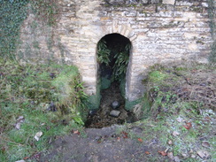
A little further on my Dictaphone stopped working due to dead batteries. This was more than an annoyance, as I had swapped them out for some cheap batteries before the previous walk. Since the next shop was not until Bromham, a few miles further on, I started writing my notes in my emergency notebook. I was in a bad mood as I passed through a series of clapper gates towards Stevington. One little thing raised my spirits slightly: a little spring trickled out through an archway in the churchyard wall, the scene feeling rather ancient and timeless.
My trousers were fairly muddy as I walked through Stevington, and as I headed down the road a gentleman asked me if I was doing the Ouse Way. I replied that I was, and he asked me for my contact details as he wanted to walk it some time. We strolled down the road until we reached a community shop just off to one side, which I would have missed if he had not been with me. I went in and, joy of joys, they had batteries for my Dictaphone! I chatted to the man for a few minutes before saying goodbye and heading off down the road, suddenly in a much better mood. For the second time today I had grabbed victory from the jaws of defeat, and all due to a few kind words from a stranger.
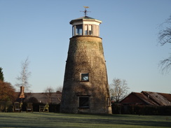
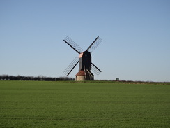
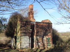
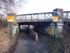
The path passed close to, but not by, Stevington windmill, which stood proudly in a field, and crossed an old railway trackbed before passing a ruined building - in gloomier conditions it would have appeared fairly spooky. A fairly nondescript track took me into Bromham, the first village of the day that I could not describe as picturesque. An ancient bridge took me over the river, with the water flowing fast through its arches. The bridge was long, but thankfully there were regular refuges I could nip into to avoid the traffic.
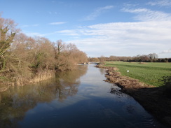
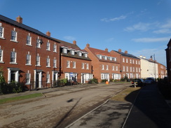
Immediately after the bridge the trail joined a path that rejoined the river bank and passed under a concrete viaduct that carried a road bypass overhead. The next mile proved an easy and pleasurable riverside walk; a lake on the other side of the river, which I thought to be a flooded pit, seems to be a rowing lake and aqua park. The only downside to the walk was the traffic noise; my rather elderly map showed the road to be a minor, dead-end one, yet it seemed to be carrying a steady stream of traffic. The answer came a little further on, when the trail left the riverbank and diverted to a new roundabout that led into the new development of Great Denham.
None of this village was on my map, but fortunately lamppost blazes took me on past a couple more roundabouts towards a new shop. Shortly afterwards the blazes appeared to end and I took a wrong turning. Eventually I decided to use Google Maps on my mobile to negotiate the new road layout, and I ended up passing a mixture of recently-built and half-built houses until I reached a new bridge over the river. This allowed me to access to a footpath that took me back to the trail. Looking at the maps when I got back, it appears that the trail headed off through a new building site, so this is an area I will have to walk again in a few years once the development has been completed.
A good path took me on between the development's southern edge and the river. It was a fairly nondescript walk into Bedford, the only thing of any real note being a low railway bridge that I had to duck under. Once in Bedford I decided to extend the walk slightly, to redo a stretch of the trail that I had got wrong on a previous walk. This took me about half a mile further on, after which I headed back to a main road and headed back towards the city centre. I have never really liked Bedford, but parts of this little diversion showed a slightly more pleasant side, with the area around Bedford Girl's School being nicer than some of the areas nearer the centre.
Since I was still feeling fit and there was still enough daylight I diverted to do a loop around Bedford St John's railway station, an area that might soon change if the planned Bedford to Cambridge rail link is ever built, as the current station is probably in the wrong place. After this it was simply a case of walking back to the car. It had been an unusual day's walk: there had been two events that should have annoyed me, but I ended up enjoying the walk.
Now for the areas further upstream, and the wonders of Milton Keynes ...
 |
 |
|
Directions
This walk starts off on the road at the entrance to Harrold Odell Country Park, at SP95595667. Leave the road to head up the access road into the park. When the road soon swings to the right to enter a car park, continue straight on to join a good gravel path that heads past a lake on the left and soon reaches an overflow car park. Continue on along the obvious track, keeping the lake on the left. Three quarters of a mile after entering the park, the path passes a little children's play area on the right before it ends at Horsefair Lane in Odell. Continue straight on up this lane for a few hundred metres until it ends at a T-junction beside the Bell Pub at SP96535770.
Turn right to follow a road as it immediately sweeps to the left; there is a pavement on the right that runs alongside a wall. The road climbs as it sweeps to the right to reach Odell Church on the left. Immediate after passing the church, turn left up Church Lane. This lane climbs uphill and curves to the right; when it curves sharply to the left after a third of a mile, continue straight on along a track that runs between hedges. It immediately passes through a gap in a hedge ahead to enter a second field; follow the hedge on the right. It goes through another hedge gap into a third field, and finally through a broad band of trees to enter a fourth. In the fourth field angle slightly to the left, aiming for the junction of a hedge on the left and an area of woodland in the far corner; it may be easier to follow the edges of the field rather than traipsing across. At the far corner, go straight on through a gap between a tree and a short section of wooden fence, and then turn half-right to join a path that runs through the trees. After ten yards the path turns to the left to head eastwards; at the end of the wood, go through a gap beside a short wooden fence to reach Yelnow Lane at SP98035935, a little under a mile after leaving Church Lane.
Turn right to join the lane; it immediately curves to the left, and after half a mile reaches a junction on the right with Lodge Road in Sharnbrook at SP98765968, with an impressive gateway across the road to the left. Turn right to follow Lodge Road for a third of a mile until it ends at a T-junction with Church Lane. Turn left to follow this road eastwards; it passes St Peter's church on the left, and after a quarter of a mile ends at another T-junction. Turn right down this road, and when it curves to the left after a quarter of a mile, turn right to go through a metal bridleway gate that lies between driveways on either side, signposted for Pinchmill Islands.
This path runs between fences before emerging out into a field. Keep a fence to the right, beyond which is a garden containing an old windmill stump. In the corner of the field, go through a bridleway gate and turn half-left to head diagonally across the field, aiming for a hedge corner ahead. At the corner, turn left to cross a footbridge over a stream. On the other side go through a gate and follow the obvious path as it curves to the right to reach a footbridge over another stream. Cross this, and on the other side follow the path, keeping a stream away to the right, which soon leads to another footbridge. The path crosses it and curves to the right between two river streams to reach another two footbridges that span the river. On the other side, the path turns left through trees; after a short distance it curves to the right over a plank footbridge to reach a stile. Head away from the river, following a fence and hedge on the right. The path crosses a couple of rough tracks leading into the field before meeting a complex junction of tracks at the end of a road by Brook Farm at SP99945842.
Immediately turn half-left across the road to reach a stile that leads into a field. On the other side, turn left, initially following a fence guarding a barn on the left, and at the top of the field cross a second stile through a hedge. Continue straight on uphill, nearly paralleling some power lines above and to the right. Go through a gap in a hedge and immediately cross two plank footbridges to reach a clappergate that leads into another field. Climb uphill, following a hedge on the left; at the top go through a clappergate and turn left to walk between fences. Go through another clappergate and turn right to join a rough track that soon reaches a minor road to the north of Radwell. Cross this road and head straight on down another track. This soon curves to the left before ending at a T-junction with Moor End Lane in Radwell. Turn right to follow this road south; after a quarter of a mile a road leads off to the right at TL00505744.
Turn right and follow this road as it heads uphill; it soon ends at another T-junction. Turn right along this road for a few yards, and then go through a metal clapper gate in a hedge on the left to join a footpath. This passes between fences guarding paddocks and crosses a rough track before crossing more paddocks; go through any gates met on the way. It eventually goes through a gate and starts following an area of woodland on the left, with the river below on the far side of the trees. Keep the trees on the left as it passes gaps in hedges into two fields, slowly curving to the left. It soon joins a good-quality track with a raised pipeline on the left beside the trees. The track enters a golf course; continue following the trees on the left. When the track curves away uphill to the right, continue across grass, with trees to the left and the golf course to the right. When the end of the golf course is reached by the 18th tee, turn right to head uphill alongside a hedge on the left. Go through a clappergate and immediately turn right to pass a tennis court on the left. Follow a hedge on the right, which curves to the left and becomes an area of woodland. Pass playing fields and then a children's play area on the left to reach a wooden clappergate beside a field gate that leads out onto Pavenham Road at SP99865551.
Turn right to follow the road westwards; there is a pavement on the right-hand side of the road as it enters the village of Pavenham. After a little over half a mile on the road, and shortly after passing the Cock Pub, turn left down Mill Lane. When this ends, turn half-right to go through a clappergate and continue along a path that runs between hedges. The path immediately curves to the right; when the hedges end follow the path through trees with the river down to the left. Go through a metal gate and continue on, following a hedge on the right. The path climbs slightly and then falls to reach a little bridge over a ditch and a clappergate. On the other side, angle along the field with the river to the left, paralleling the hedge away to the right. Cross a boardwalk over a muddy area and continue on. Another muddy area leads to a gate and footbridge over a stream; on the other side go through a metal clappergate and continue on, following the river on the right. Eventually the path angles to the right away from the river, passing a solitary tree to reach a hedge on the left. Follow this to a clappergate beside a field gate and then head between fences. The path curves to the left to another clappergate. Follow a bank, and then woodland, on the left. Turn left through a clappergate and over a plank bridge and follow hedges to another clappergate, after which there is a hedge on the left and a fence on the right. The path turns sharp right and continues through a series of five clappergates before finally reaching a wooden gate. The path passes a wall belonging to Stevington chuchyard on the right, and then curves to the right to meet the end of Church Road in Stevington at SP99075359.
Join church Road and follow it as it heads south into Stevington. When a crossroads beside the village cross is reached after a quarter of a mile, turn left along Park Road. After a quarter of a mile, and shortly before a right-hand bend, turn right down a track called Windmill Lane. This passes some houses and converted barns on the right; when it curves to the right shortly after the barns, take a track that leads off to the left, keeping a hedge to the left. The track jinks to the right and left past a small area of waste ground to reach a junction with another track. Turn right to head uphill to the south along the track to reach an old railway line. Head straight on to cross the line, and then go through a gap in a hedge to enter a field. Pass a ruined cottage on the left, and then continue uphill, aiming for a corner of a hedge ahead. At the corner turn half-left to follow the hedge on the right southeastwards. When the field ends the path passes through a gap in a hedge into another field and continues between fences. It passes under some power lines and enters a third field. Keep a fence on the right as the track approaches an industrial barn on the right; here turn half-left to join a better-quality track that heads eastwards past trees and pallisade fencing on the right. The track curves to the right slightly before passing a metal gate to join the end of Molivers Lane in Bromham. Continue along this road for a third of a mile until it ends at a T-junction with Village Road at TL00945133
Turn right to head south along Village Road for a couple of hundred metres; pass the entrance to Grange Lane on the right, and then turn left down a surfaced track that leads to a pedestrian gate beside a cattle grid. Immediately on the other side, turn right along a path that runs south across a field. It crosses a green track and then a more substantial track. Continue down the field, and at the bottom go through a clappergate to reach a footbridge over a stream. On the other side of the bridge, the path continues between fences before emerging out onto a surfaced lane called Millfield. Continue down this until it ends at Bridge End. Turn left to follow this road eastwards; it soon crosses the ancient Bromham Bridge over the river. Care needs taking as there is no pavement.
The bridge becomes a causeway; when this ends at TL01305060, turn right down a short track that leads to a clappergate beside a field gate. Go through the gate and follow the track as it curves to the right and then left to join the riverbank; it soon passes under a viaduct carrying the A428 road overhead. This good path heads south beside the river for about a mile; shortly after passing under some power lines the path curves left away from the river at TL01474886, squeezes past a field gate and climbs up a slope to reach a roundabout on the A428. Carefully cross the A428 as it feeds into the roundabout, and then continue along Kingswood Way into Great Denham. At a second roundabout (with a park and ride car park to the right), take the second exit to continue south-eastwards along the same road. When this curves to the right, turn left up Saxon Way and then almost immediately right along Anglia Way.
Great Bromham is still being built at the time of writing, and the official path is hard to find in the new development. Instead, follow Anglia Way as it curves to the right and then left to head in a rough southerly direction. After about half a mile the road curves to the right to reach a roundabout with the A428 at TL01884789. Take the first exit off to the left - a track - and head past a field gate. The track then curves to the right and descends down; when it soon ends turn left through gates to join the floodplain. Follow a hedge on the right eastwards for a few hundred metres. Do not cross a footbridge when it is reached ahead, and instead curves left along a good path; here the official route of the Ouse Valley Way is rejoined.
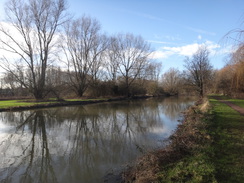
After two-thirds of a mile the good path joins the northern bank of the river, which it follows as the river curves to the right to head eastwards. When the path forks at TL03534892, either follow the riverside path to the right to Queen's Bridge, or take the official path that heads on until it ends at a T-junction with another track in front an industrial building. Turn right to follow this new track to reach Queens Bridge. Do not cross the bridge, and instead continue along the riverside path for a quarter of a mile until it reaches two low bridges that carry railway lines over the river. Continue on to reach another low rail bridge, with the curvy Bedford Siding footbridge alongside offering a less height-limited alternative. A short distance on the A5141 road bridge in Bedford is reached at TL04614938.
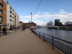
The end of this walk is a few yards away across the bridge on the southern side of the river, but I decided to lengthen it a little. Pass under the A5141 bridge and head on along the riverside promenade through the centre of Bedford. The path passes under a projecting part of Bedford County Court, and then climbs a slope to reach the A6 road bridge. Turn right to cross the river, and immediately on the other side turn right past bollards into St Mary's Gardens. Immediately turn right down another path that leads towards the southern bank of the river, and then right to head under a low arch of the A6 bridge. Continue following the river on the left; the path crosses a couple of footbridges over streams and then curves to the right. Ignore a path that leads off to the left across another bridge, and instead turn right to reach a road. Cross the road and continue on along a cycle path to another footbridge, with a river channel on the left, until a black footbridge is reached over the channel at TL05604943. Here the Ouse Valley Way is left.
Turn right down a path that heads away from the river, passing a car park on the left. The path emerges onto a roundabout on the A603/A5140. Turn right to follow Cardington Road back towards town, passing Bedford Girls' School on the right. When this ends at a T-junction with the A6 beside a church, cross the A6 using the pedestrian crossing and continue on along Caudwell Street. Cross any roads coming in, and follow the road as it passes Prebend Street on the right (and the car park that marks the end of the walk), and rises to climb on a bridge over a railway line. Turn left down Britannia Road, and follow it until it ends at a junction with the A6 Ampthill Road. Turn left to follow the road as it climbs over a bridge over a railway line; Bedford St Johns station is down a staircase to the left at the top of the bridge.
To get back to Prebend Street car park, continue on down Ampthill Road until it reaches a large roundabout. Take the first road to the left, Kingsway, and follow this until it reaches Caudwell Street once more. Cross Caudwell Street, and then left to follow the road westwards; after a couple of hundred yards, turn right up Prebend Street. The car park is a few yards away on the left.
 |
 |
|
Distances
| From | To | Distance (m) | Ascent (ft) | Descent (ft) |
|---|---|---|---|---|
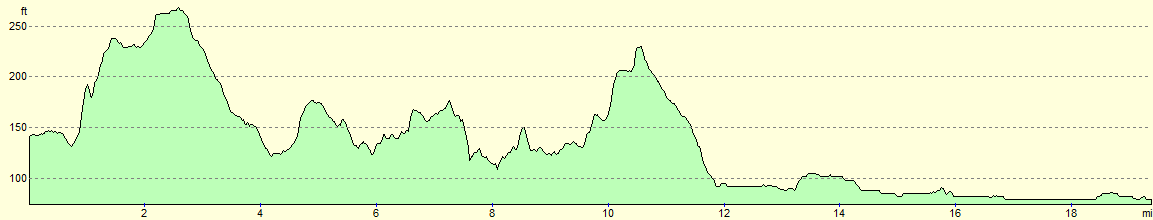
| Harrold | Radwell | 5.4 | 240 | 230 |
| Radwell | Bromham | 6.1 | 233 | 226 |
| Bromham | Bedford Prebend Street | 7.9 | 79 | 154 |
This makes a total distance of 19.4 miles, with 552 feet of ascent and 610 feet of descent.
For more information on profiles, ascents and descents, see this page
 |
 |
|
Transport
Several bus servics run between Bedford and Harrold; the Grant Palmer #25 and #26 services run a few times a day, on the way to either Sharnbrook or Rushden. The Stagecoach #51 service runs less frequently, on the way to Rushden.
 |
 |
|
 |
 |
|
 |
 |
|
 |
 |
|
 |
Disclaimer
Please note that I take no responsibility for anything that may happen when following these directions. If you intend to follow this route, then please use the relevant maps and check the route out before you go out. As always when walking, use common sense and you should be fine.
If you find any information on any of these routes that is inaccurate, or you wish to add anything, then please email me.
All images on this site are © of the author. Any reproduction, retransmissions, or republication of all or part of any document found on this site is expressly prohibited, unless the author has explicitly granted its prior written consent to so reproduce, retransmit, or republish the material. All other rights reserved.
Although this site includes links providing convenient direct access to other Internet sites, I do not endorse, approve, certify or make warranties or representations as to the accuracy of the information on these sites.
And finally, enjoy your walking!
Nearby walks
| # | Title | Walk length (miles) |
|---|---|---|
| 184 | A circular walk between Hargrave, Raunds and Rushden | 18.4 |
| 213 | Rushden to Northampton | 16.4 |
| 214 | Sandy to Bedford | 12.0 |
|
|

|