Walk #1013: Linlithgow to Croy
 |
 |
|
General Data
| Date Walked | 11/08/2018 |
| County | Lothian, Central Scotland, Strathclyde |
| Start Location | Linlithgow station |
| End Location | Croy station |
| Start time | 08.40 |
| End time | 16.55 |
| Distance | 22.3 miles |
| Description | This was a pleasant walk following the western half of the Union Canal and a long stretch along the centre of the Forth and Clyde Canal. |
| Pack | Today I carried my 30-litre Karrimor rucksack, filled with water, my spare waterproofs, a book and other odds and ends. |
| Condition | The underside of my feet suffered slightly before I took my boots off at my rest, but were fine afterwards. The biggest problem was a back spasm I got about a mile from the end. |
| Weather | Today was a mixture of sunshine and cloud, and was perfect weather for walking in short shirt sleeves. Although some clouds were rather dark, there was no sign of any rain. |
| OS map | Landranger number 66 (Edinburgh, Penicuik & North Berwick) and Landranger number 64 (Glasgow, Motherwell & Airdrie) |
 |
 |
|
Map of the walk
Maps courtesy of Google Maps. Route for indicative purposes only, and may have been plotted after the walk. Please let me have comments on what you think of this new format. For a detailed table of timings for this walk, please see the table file.
 |
 |
|
Notes
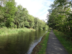
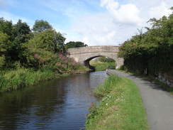
Breakfast was at seven this morning, and I quickly scoffed it down before driving to Larbert station to catch a train to Linlithgow. This arrived in the town a little after eight thirty, and I headed up the road to join the Union Canal, reversing the final part of yesterday's walk. I felt exceptionally tired; I am unsure why, although perhaps it was a reaction to yesterday's long walk. The canal through Linlithgow is fairly attractive and well-kept, and the towpath was busy with joggers, dog-walkers and cyclists. The path was tarmac underfoot, meaning I could make quick progress at the risk of my feet suffering.
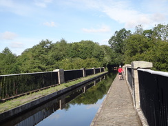
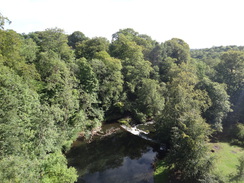
The first couple of miles mainly involved avoiding other towpath users - fortunately most of the bikes had bells, meaning a quick ring would alert me to them before they arrived. It was not a spectacular stretch of canal, but it was pleasant. Soon I reached a rather magnificent aqueduct over the River Avon; designed by Thomas Telford, it is the second longest aqueduct in Britain. I took my time on the walk across, and paused to enjoy the view down into the valley below as cyclists squeezed their bikes past me on the narrow towpath.
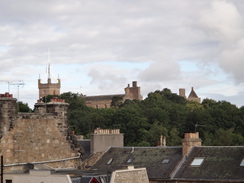
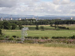
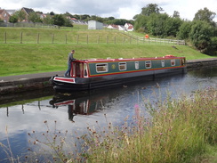
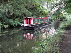
There were occasional signs of ancient industry; for instance the abutments of an old railway bridge that once spanned the canal to reach a quarry on the other side. A little further on, barely visible through the trees, was the cleared site of a factory that once made refractory bricks. More interestingly, the ruinous Almond Castle stands close by - though I'm unsure how long it will remain standing, as it is apparently in very poor condition. On yesterday's walk I had seen very few boats moving on the canal, but today it was fairly busy, mainly with boats heading east towards Edinburgh - perhaps because it was the weekend.
Milestones sat beside the towpath at regular intervals, although unusually there were two sets: old ones, so eroded that the words were often illegible, and newer ones that could clearly be read. Old and new were never together, probably as a result of the canal having been lengthened when it was reopened a few years ago. The canal's reopening could be seen in other places, for instance where the canal jinked to go under a new road bridge, where it clearly used to continue straight on.
The canal headed on through Polmont, which I only knew as the scene of a tragic rail crash in 1984, and where the walls of a Young Offenders' Institution stood sternly over the other side of the canal. The prison, and the Tescos store on the other side of the canal, used to be a Nobel factory for making detonators. This had its own internal railway network, the factories on both sides of the canal being connected by a railway swing bridge. A picture on a board showed a locomotive sitting partly in the canal after it had tries to cross whilst the bridge was open. The factory finally closed in 1969, and there is now little trace of it on the ground.
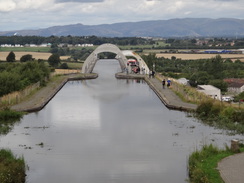
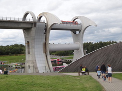
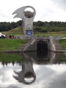
Beyond this, new housing lay scattered up the hillside, whilst the towpath joined an access road to an industrial estate for a short distance. It was an enjoyable stroll, although I was keen to reach the end of the Union Canal at the Falkirk Wheel.
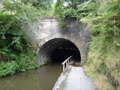
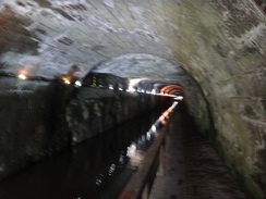
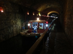
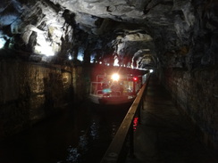
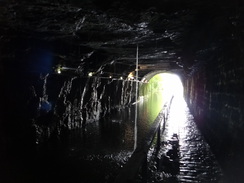
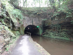
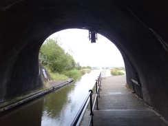
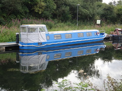
But first I had a tunnel to negotiate. On a previous walk I had noticed signs for a path that ran across the top of the tunnel, and I expected to have to take that. However as I approached I saw that the towpath extended through the tunnel, with a string of small lights on the far wall providing scant illumination. In places the towpath was wet, whilst in others it was bone dry. Two boats came towards me in convoy; they were broad, and barely fitted the width of the canal - it was the first time I had seen boats in a tunnel, and it was enjoyable, even if they left behind them a smog of fumes.
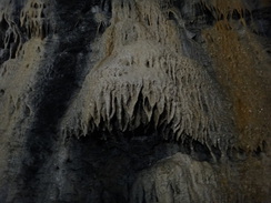
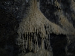
Parts of the tunnel were lined with bricks whilst others were unlined, leaving towering voids overhead, evidently where the men had excavated until they found rock solid enough to form a roof. At one point I had to squeeze to the side as a family cycled by, splashing through the water and making noises that were weirdly distorted by the tunnel's uneven ceiling. Water trickling down the walls had made candelabra-style shapes, whilst further on water poured out of a hole in the roof. All too soon the tunnel ended, and I was sad to see daylight once more. Walking through the tunnel was the highlight of the day, if not the trip.
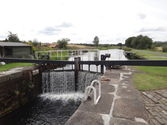
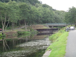
The western end of the tunnel led to the part of the towpath I had walked previously, and this was consequently fairly boring. The site of an old flight of locks that led down to the Forth and Clyde canal marks a path that is the only route between the two when the Falkirk Wheel visitors centre is closed - which seems a little stupid. From here on, I was following a 'modern' canal built when the Union Canal was restored at the turn of the Millennium. Two locks - the only ones on the 32 miles of the Union Canal - led down to a modern tunnel under a railway line, and then onto the Falkirk Wheel - which certainly makes a dramatic visual impact. I took a little diversion to see the route of the Antonine Wall which runs above the tunnel, and then descended to the visitors centre.
A bench was available, so I sat down to much on the sandwiches I had bought before the walk. I had now completed the Union Canal, and was about halfway through the walk between Edinburgh and Glasgow. I took a rather odd selfie whilst sitting at the bench, then shouldered my rucksack and started off west along the Forth and Clyde.
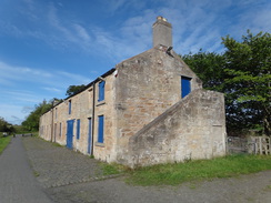
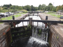
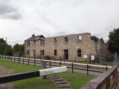
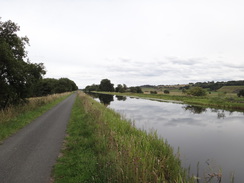
This was a fairly easy plod; the towpath took me to Bonnybridge, and then on to the villages of Haggs and Banknock. On the way several locks lifted boats up, where I had been expecting them to start lowering them towards the sea - evidently I had not yet reached the canal's summit level. One lock had a very decrepit building beside it, with most of the roof and first floor having gone - a sad sight.
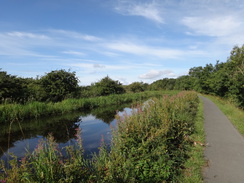
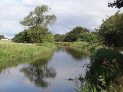
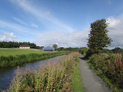
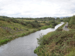
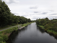
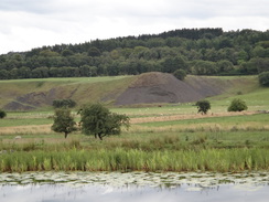
A long, straight section of canal followed, with the canal about twice its normal width. This looked more like a river, and perhaps acts as a pond for the locks further west. There was not much to see, aside from an old tip of grey material alongside a ruined mine building, so I just put my head down and walked. Things eventually improved as more interesting scenery opened up on the other side of the canal. This led to Auchinstarry, where a pub seems to be the focus of a marina - this was the only pub I had passed today, and too near the end of the walk to be worth visiting.
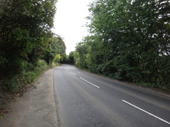
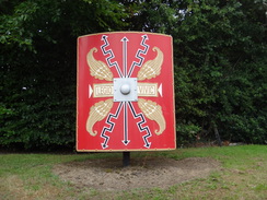
I left the canal at Auchinstarry, and headed up a steep road towards that station in Croy village. On the way I stepped on a little rock that had fallen from the side of the cutting and was rewarded with a sudden back spasm. This was almost paralysing for a couple of seconds before the pain dissipated. Annoyed, I continued up the road into Croy, where a sign in the form of a shield marked the village's connection with the Antonine Wall.
I stopped off at a shop to buy some painkillers, and I took a couple as I walked to the station. As I waited a steam engine sped through pulling a support coach; too fast for me to take a photo, but leaving behind it a faint, evocative smell of steam and smoke.
It had been a good day's walk, with the tunnel being an absolute highlight (or should that be deeplight?). However the twinge in my back did not bode well, and the weather forecast for tomorrow is awful.
 |
 |
|
Directions
This walk starts off at Linlithgow railway station at NT00527706. Leave the station through the car park, and then go through a gap in a low wall to join Back Station Road. Turn right up Back Station Road, following the wall on the right; there is a pavement beside the wall. The road ascends and then jinks to the left as a road joins straight ahead; follow the road around to the left, and then immediately cross it and go through a gap in a fence to join the towpath of the Union Canal at NT00457697.
Turn right to start following the canal westwards, with the water on the left. It heads in a rough westerly direction, and after 8.8 miles reaches the eastern portal of the Falkirk Tunnel at NS88397839. There is a towpath through the tunnel, and small lights that provide a little illumination; however it might be best to take a torch with you.
The tunnel ends near Falkirk High Station; emerge from it and follow the canal as it curves left to take a more west-northwesterly course. It passes the site of an old lock, which is the old top lock of the flight down to the Forth and Clyde. If the Falkirk Wheel Visitors Centre is not open, then you will need to turn right to head down towards the other canal. After 1.6km the towpath passes a little stub of the canal away to the left, and curves right to reach an aqueduct over a road. 700 metres after this, the towpath passes a vehicle barrier and climbs to reach a track. Turn left along the track and follow it as it immediately curves right. When it soon curves left to cross a bridge over the canal, head straight on past vehicle barriers to descend a slope that rejoins the canalside towpath. Follow the towpath westwards for another 400 metres to reach a lock at NS85397962.
Take a path that dives down past two locks. After the second lock, the towpath curves right to head north to reach Rough Castle tunnel. Head through this, and on the other side continue on for a few metres until the towpath forks. Take the right-hand fork that descends down, passing a car park on the right and then curving left to descend towards the Falkirk Wheel visitors centre at NS85278020.
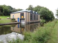
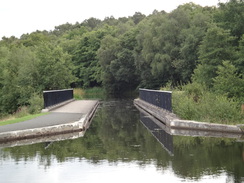
Pass the visitor's centre away to the left, and then turn right to head north away from the wheel, passing between a lock on the left and a building on the right. At the far end of the lock, turn right along a surfaced path that passes the building on the right to reach a gate - this gate is only open when the visitor's centre is open. Go through the gate to reach a swing-footbridge over the Forth and Clyde canal at NS85318023.
Cross the bridge, and then turn left to start following the Forth and Clyde canal westwards. It passes through Bonnybridge and then past Banknock; after nine miles bridge 16 is reached over the canal at NS72067690, with a pub and marina in Auchinstarry over the canal to the left. Just before bridge 16, turn right up a track that angles away from the canal; it soon passes bollards to end at the B802 road. Turn left to follow the road as it crosses the bridge over the canal, and head on to a roundabout that leads down to the marina.
Cross the roundabout, and continue south along the B802 as it climbs; there is a pavement on the left. After a third of a mile, turn left along Constarry Road (this is still the B802); do not continue on south. This road heads eastwards, entering the village of Croy and curving to take a more southeasterly course. Follow the road through the village, and after two-thirds of a mile Croy railway station is reached on the right. Just before the bridge over the railway is reached, turn right to reach some steps that lead down to the station at NS72977551, where this walk ends.
 |
 |
|
Distances
| From | To | Distance (m) | Ascent (ft) | Descent (ft) |
|---|---|---|---|---|
| Linlithgow station | Polmont | 5.7 | 30 | 0 |
| Polmont | Falkirk Wheel | 6.0 | 2 | 100 |
| Falkirk Wheel | Banknock | 4.7 | 30 | 7 |
| Banknock | Auchinstarry | 4.6 | 10 | 0 |
| Auchinstarry | Croy station | 1.3 | 115 | 39 |
This makes a total distance of 22.3 miles, with 187 feet of ascent and 146 feet of descent.
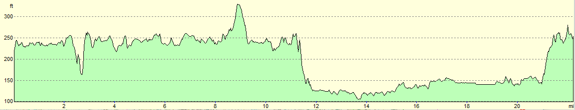
For more information on profiles, ascents and descents, see this page
 |
 |
|
Accommodation
I spent the night at the Premier Inn hotel in Larbert, near Falkirk. This was about half a mile from Larbert railway station, which has regular services to and from Edinburgh and Glasgow without changes, allowing you to access large areas of the central belt.
Unfortunately it was rather expensive when I visited, as the Edinburgh Fringe was on in Edinburgh, and the European Championships in Glasgow, pushing up prices.
Transport
Trains regularly run between Croy and Linlithgow. See the National Rail Enquiries website for more details.
 |
 |
|
 |
 |
|
 |
 |
|
 |
 |
|
 |
 |
|
 |
 |
|
 |
 |
|
 |
 |
|
 |
 |
|
 |
 |
|
 |
 |
|
 |
 |
|
 |
 |
|
 |
 |
|
 |
 |
|
 |
 |
|
 |
 |
|
Disclaimer
Please note that I take no responsibility for anything that may happen when following these directions. If you intend to follow this route, then please use the relevant maps and check the route out before you go out. As always when walking, use common sense and you should be fine.
If you find any information on any of these routes that is inaccurate, or you wish to add anything, then please email me.
All images on this site are © of the author. Any reproduction, retransmissions, or republication of all or part of any document found on this site is expressly prohibited, unless the author has explicitly granted its prior written consent to so reproduce, retransmit, or republish the material. All other rights reserved.
Although this site includes links providing convenient direct access to other Internet sites, I do not endorse, approve, certify or make warranties or representations as to the accuracy of the information on these sites.
And finally, enjoy your walking!
Nearby walks
| # | Title | Walk length (miles) |
|---|---|---|
| 564 | Aberdour to Culross | 22.0 |
| 565 | Culross to Boness | 16.8 |
| 566 | Boness to Muirhouse | 18.9 |
|
|

|