Walk #951: Sudbury to Colchester
 |
 |
|
General Data
| Date Walked | 26/06/2012 |
| County | Suffolk, Essex |
| Start Location | Sudbury station |
| End Location | Colchester North station |
| Start time | 08.05 |
| End time | 16.17 |
| Distance | 20.8 miles |
| Description | This walk followed parts of the Stour Valley Path and Essex Ways across the border of Suffolk and Essex. |
| Pack | Today I carried my 30-litre Karrimor rucksack, filled with water, my waterproofs, a book and other odds and ends. |
| Condition | I feel quite tired after this walk, and was glad to reach the end. |
| Weather | Today was mainly bright, sunny and quite warm, although there were significant periods of cloud. |
| OS map | Landranger number 155 (Bury St Edmunds, Sudbury & Stowmarket) and Landranger number 168 (Colchester, Halstead & Maldon) |
 |
 |
|
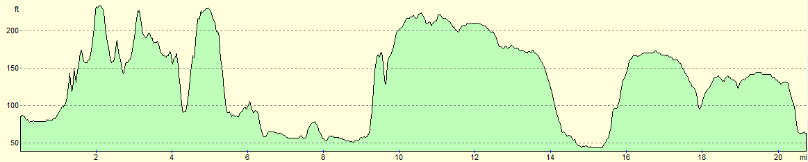
Map of the walk
Maps courtesy of Google Maps. Route for indicative purposes only, and may have been plotted after the walk. Please let me have comments on what you think of this new format. For a detailed table of timings for this walk, please see the table file.
 |
 |
|
Notes
It had been a month since my previous walk; another long gap in a year that has been disappointing from a walking perspective. Decorating our new house and the consequent house move had taken priority. However with the keys to our rented house handed over last Thursday, I had no reason not to get back into the country.
On my last walk I had reached the eastern trailhead of the Stour Valley Path completing that trail, but I still had a six-mile gap from Sudbury to Bures to complete to fully complete the trail. I did that particular stretch as a stroll from Sudbury to Marks Tey five or six years ago, but I decided to do it again. The drive down to Sudbury went well, and soon enough I was parked up in the station car park. I was desperately in need of the toilet so I walked quickly through the town to the bus station where I knew there were some toilets. Annoyingly these were not yet open, so I jogged back to the car, got my kit together and headed off past the leisure centre.
My first task was to join the Stour Valley Path, which involved a walk along an old railway line. I have done this several time before, but instead of admiring the occasional views across the river, I was more concerned about finding somewhere to relieve myself before a kidney burst. Eventually I nipped under a bridge, waded through nettles and found a quiet spot out of view.
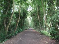
Back on the trail, I had a play with my new Dictaphone. My old and faithful one had given up the ghost the previous week and had been replaced by a hurried purchase. I had not had time to get used to it, and so played with the buttons as I struggled to get it to behave as I wanted. It took an age, but eventually I figured it out. I left the old railway line in Ballingdon and joined the Stour Valley Path. Initially this took me through an area of parkland before joining roads that headed uphill.
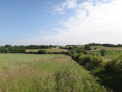
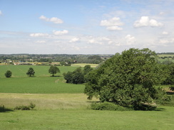
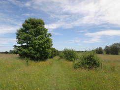
It was a bit of a relief when the roads were left behind, and a surprisingly hilly path took me south. None of the hills were in any way high and the gradients were gradual, but my legs were not hill-fit after such a long lay-off and I found the undulations difficult. Although not classic the scenery was pleasant and I soon found myself enjoying the stroll. This long stretch ended when the path erupted into Great Henny churchyard, after which tracks and roads took me eastwards.
A large lorry carrying piling equipment squeezed past me, and the narrow, tree-lined road seemed like an odd place for such a hefty load. The reason soon became obvious: a road was closed and I came across the lorry parked off a track. Two sets of power lines crossed the countryside to my right and the work was obviously something to do with that, although I could not tell exactly what it was.
The next couple of miles were rather bitty and unsatisfying; the trail rose and fell without any particularly pleasant views to reward the energy spent. It joined a road for a short distance where I had to step right into a patch of nettles to allow a JCB loadall past; the lane was so narrow that its raised bucket was pushing through the hedges on either side. Another path took me down to reach a road in Lamarsh.
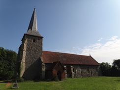
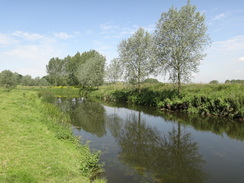
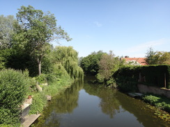
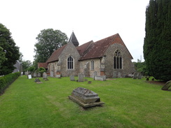
Here was the first treat of the day - Lamarsh church, a round-towered church with whitewashed walls that looked stunning in the sunshine. I nipped inside to see the interior, before avoiding a man who was manoeuvring a ride-on mower amongst the gravestones. After crossing a railway line the Stour came into view for the first time since Sudbury, but these tantalising glimpses proved to be all too fleeting as a track took me south into Bures.
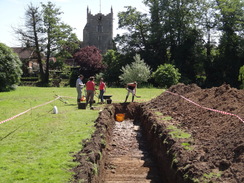
Bures had been bedecked with red, white and blue bunting during my last visit to the village a month previously, and although most of this had gone it had been replaced with a more interesting feature. Numerous people were scattered around the floodplain near the river, with large linear heaps of spoil bespoiling the grass. Intrigued, I approached a man standing beside a makeshift tent-shelter. It turned out that he belonged to Cambridge University and was involved with a series of community archaeological digs. This particular one had set out to find a secondary river channel that had been filled in sometime around the seventeenth century. It was hardly a grand objective - there was going to be no Roman villa found, no Saxon gold - but the objects they found would be the thrown-away or discarded rubbish of their ancestors.
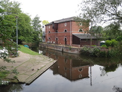
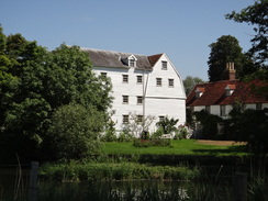
It was pleasing to see a score of people volunteering for this work, and I said hello to a couple before heading across the road to the village shop, where the lady behind the counter was very friendly. Soon however I was following the trail eastwards out of the village. Before I knew it I was passing Bures Mill, with its white clapperboard shell glittering in the sunshine. Sadly that same sun was in the wrong position for me to take any good photos of it, although I was not too bothered as I got some decent ones on my previous walk a month earlier.
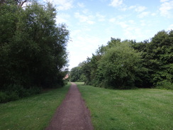
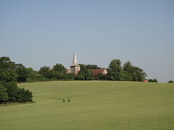
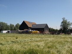
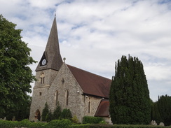
The trail headed across the floodplain, passing a large black building on the way. This was a well-disguised pumping station that was under construction, and much work had been done since my last walk. That was not the only noticeable change, and the grass that had been short was now up to me knees. An easy climb took me up onto the Lodge Hills, which rewarded me with some good views, before a descent and climb through woodland led me to Womingford Church.
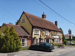
A man was mowing the grass in the graveyard, the third time I had seen such an operation today. Are Tuesday's the day-to-mow-graveyards in this area? Sadly this marked the place where I would leave the Stour Valley Path, and I started heading south along a road. After passing a shop I reached a pub. It seemed like a decent time to stop, and so I nipped in. I was immediately made very welcome and I had a couple of pints of bitter shandy as I relaxed and read a paper.
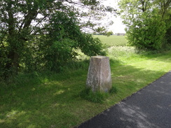
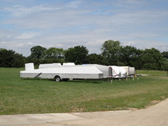
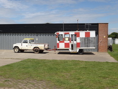
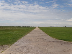
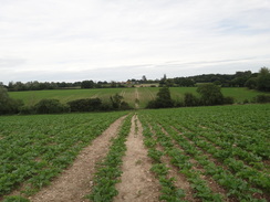
I was keen to get on, and so I shrugged my rucksack back onto my shoulders and headed on past a trig pillar to reach Wormingford airfield. Unlike many of the myriad of Second World War airfields in East Anglia, this one was surprisingly intact. The entire perimeter track was complete, if narrowed in width and slightly broken underfoot, and the line of the main runway was also easily discernible, if only in grass rather than concrete. The reason for this is that part of the site is still in use by a gliding club, and I was soon passing ranks of glider trailers and a small hanger.
Initially opened as a landing-ground in the First World War, it was reopened and expanded in 1942 before being disposed of by the military in the 1960s. Much of the runways and tracks were broken up, but public footpaths now run all the way around the perimeter. One recent alteration was a large bank, which was part of an artificial water-storage pond for agricultural purposes.
All too soon I left the rather windswept and exposed airfield behind and joined roads that led me into the village of Fordham. I took a busy road that headed south from there, but fortunately an off-road grassy path had been created on the other side of the hedge. Soon I was faced with a choice: my original plan was to follow roads and paths south as far as Marks Tey. That would have only been about a sixteen mile walk and I was feeling fit, so I decided to extend the walk by following the Essex Way east towards Colchester.
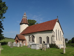
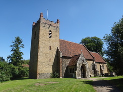
I met the trail at the bottom of the hill, and started following it eastwards along the Colne Valley. The river remained out of sight for much of the time, and when it did come into view it was narrow and scarcely worthy of being called a river. Despite this I enjoyed the stroll, and it felt like a shame when the trail climbed out of the valley to reach West Bergholt church. This was now under the guardianship of the Churches Conservation Trust, and even includes some Roman bricks in its fabric. It was a wonderful space, and a vast improvement on its late-Victorian successor in the centre of the village. I spent a few minutes taking some photos and touching the fabric; running my fingers over the stonework and elegantly-carved wood. There is something wonderfully tactile about old buildings, and sometimes I feel like I cannot really get the full benefit of the place without stroking it, caressing it.
The interior of the church captivated me, and it was with some regret that I left and followed footpaths into West Bergholt. It was school-leaving time, and the road outside the school was packed with cars, whilst the pavement was filled with parents and grandparents going to pick up their children. I was faced with another choice here: I could have followed the B1508 into the centre of Colchester, but I was feeling fit and so decided to continue along the Essex Way.
A road and tracks took me to Armoury Farm, after which paths headed northeastwards, descending to cross a stream and climbing up to enter Horkesley Heath. I was feeling fine and could have walked further; however the trail now turned to head north, away from Colchester. I had no idea about public transport in that area, so I decided to head back along the A134 towards the city. Fortunately there was a pavement all the way but that was the only good thing to be said about the stroll; it was a thoroughly boring walk and very noisy near the bridge under the A12(T). There was one thing to note: a new bypass on the outskirts of Colchester meant that the last mile was much quieter than it otherwise would have been.
The journey back to Sudbury involved a change of trains at Marks Tey; I had a long wait at Colchester, but when the train pulled into Marks Tey, another was waiting in the bay platform for Sudbury. It was a stroke of luck that meant that I got home earlier than I was expecting. It had been a varied walk, with the highpoint of having finished the Stour Valley Path offset by the last few unenjoyable miles.
 |
 |
|
Directions
This walk starts off from Sudbury railway station at TL876410. Leave the station and follow the road leading away from it, passing the station car park and then a leisure centre on the left. Once past the leisure centre, turn left to walk in front if it keeping a car park on the right. Walk around the building to pass the man entrance, then turn right to walk along the edge of the car park before turning left to join an old railway trackbed. Follow this trackbed as it curves westwards for two-thirds of a mile, crossing a stream on the bridge and then the main River Stour. Shortly after it crosses a bridge over the A131 road in Ballingdon, turn right off the high embankment down a sloping path to reach a surfaced road. Turn right down this for a few yards until it ends at a T-junction with the A131 at TL866408.
Turn right to pass under the railway bridge, and on the other side turn left down a track with the embankment to the left and houses to the right. This track becomes a path that curves to the right to head southwestwards through some grassy parkland. This path ends at Middleton Road in Ballingdon. Turn left along this road for a few yards, then right up Meadow View Road. This soon curves to the left to head southeastwards. Take the first road off to the right, Pinecroft Avenue, and follow this as it passes a playground on the left. Just before the first house is reached on the left, turn left to join a footpath. Initially this climbs as it skirts behind houses through scrubland, before ascending some steps and curving to the left.
Eventually the path squeezes between two hedges and emerges out at the top of the hill. Go through a gap in a hedge and enter a field; head downhill across this field to meet a track. Cross this and continue on south along another track, keeping a field boundary on the left and a field on the right. The track starts to head uphill; at the top of the field the track emerges to join another track at TL868393. Cross the track to reach a stile through a fence; on the other side head south across a field, soon joining an intermittent band of trees on the left.
The path becomes more overgrown as it heads downhill. It passes a little pond on the left, which mostly remains out of sight. A hedge soon starts on the right; continue on downhill as a church tower becomes visible ahead. The hedge becomes a ditch as the path falls to reach a gap in a wooden fence. Go through this and continue on across a stream. Follow a hedge on the left back uphill; at the summit of the hill it goes through the hedge and continues downhill with it on the right. At the bottom of the hill the hedge on the right ends and another starts on the left; follow this uphill. At the end of this field go through a gap in a hedge and cross a plank bridge over a ditch.
Turn slightly to the left to follow a hedge on the left, and as the hedge starts to curve to the right at the corner of the field, turn left to reach a stile. Cross this and follow a hedge on the left, still aiming for the church tower ahead. When a fence is reached ahead, take a stile on the left that leads into another field. Follow the hedge on the right uphill; at the corner of the field it becomes enclosed between two hedges, eventually passing a house on the left before ending at a track. Turn right along the track and then immediately left to go through a lychgate to enter Great Henny churchyard at TL867378. Pass the church tower on the left and then squeeze past a gate next to a building and join the end of a track. Follow this track downhill to the south for a short distance until it ends at a road at TL867375.
Turn left to follow the road east-southeastwards. Follow it for 0.4 miles; pass a road junction on the right, then as the road curves to the left head straight on along a surfaced track. This soon curves to the right to pass a house and becomes unsurfaced. It crests a hill and continues on downhill towards Great Hickbush. As the track curves right towards a house, turn left along a path that follows a hedge on the right, with the house beyond the hedge. Cross a stile and continue on with a fence and hedge on the right.
At the corner of the field cross a stile and then turn right through the hedge and down some steps to enter a field. Head immediately down the middle of the field, heading under some power lines on the way. At the bottom of the field turn left to cross a footbridge, a stile and a second footbridge. After this complex, turn right to follow a field boundary on the right. The path passes Valley Farm on the right and continues uphill along a track. Just before some power lines are reached, turn right across a stile through a hedge to enter a field. Turn slightly to the right to head uphill across the field, keeping a low knoll on the right. Aim for a stile beside a field gate at the top of the hill. This stile leads back onto the track; follow it for a few yards until it ends at a road at TL880363.
Turn left to follow this road east-northeastwards for a sixth of a mile. Just before it passes under some power lines, turn right over a stile and follow a path that runs between a hedge on the right and a fence on the left. When a corner of the field is reached after a third of a mile, turn left to follow a green track east-northeastwards downhill, following a fence on the left. This track ends at Henny Road at TL889361 opposite a farm.
Turn right and follow the road southwards, passing Lamarsh church on the left. The road swings to the left and passes a pub called the Lamarsh Lion. Continue past the pub for a short distance and as the road swings to the right, turn left to continue straight on along a track. This passes buildings on the left before curving to the right towards a house. At this bend, continue straight on down a green track that passes below the house on the right. Cross a stile and descend to reach a railway line at TL896352.
Carefully cross the railway line and then a stile on the other side to enter a field. Follow a hedge on the right, with the Stour down below to the left. As the path approaches a bridge over the river on the left, the path curves slightly to the right to reach a stile through a fence. Cross this and follow the path through an overgrown area until it emerges out onto a track. Continue straight on along the track, following a hedge on the left. The track slowly curves to the right to take a more southerly course, and after three-quarters of a mile it approaches the northern outskirts of Bures. As the track curves to the right, turn left down a path that follows a hedge on the right and a fence on the left. A wall starts on the right; follow this until it ends at a junction with Station Hill in Bures at TL905340.
Turn left for a couple of yards until Station Hill ends at a junction with the B1508 road. Continue straight on and follow the B1508 as it crosses the River Stour and pass Bures Church on the right. As the road swings to the left immediately after the church, turn right down Church Square, initially keeping the church on the right. The road curves to the left and then right to head east-northeastwards through the village. Pass a car park, a community centre and then a house on the right; immediately after the house at TL909338 turn right through a pedestrian gate to enter a field. Turn half-left to head diagonally across the field to reach another pedestrian gate beside a field gate that leads out onto a track.
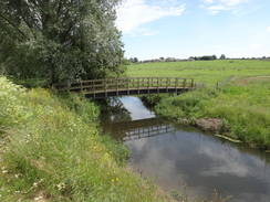
Turn right down this track, and then immediately left to head down a driveway that leads towards Bures Mill. Cross a stile beside a gate and continue on along the track. It curves to the right towards the mill; immediately after the bend turn right along a path that follows a hedge on the left. The path squeezes past the mill complex on the left and then curves to the right to head towards a footbridge over a sluice on the Stour. Immediately afterwards the path crosses a little stream to reach a clapper gate that leads into a field at TL910334.
Turn half-left to walk southeastwards across the field whilst the river curves away to the right. At a hedge cross a stile into a second field and continue on to a second stile that leads into a third field. Continue straight on across this long field as the river comes in from the left; at the end cross a third stile and a footbridge over a ditch to reach the narrow fourth field. Head across this to another footbridge over a ditch that leads into a fifth field.
Cross a spur of the field to join a hedge on the left; follow this to reach the far left-hand corner of the field. Go through a gap in this hedge and turn slightly to the right across a sixth field to reach a track running alongside the corner of a hedge at TL919329, with a newly-built (2012) waterworks building to the left. Turn right down the track for a few yards, then left to follow a hedge on the left to reach the far corner of the field. Go through a gap in the hedge at the corner to reach another field, and then turn half-right to head across this on a slight diagonal, aiming for a large bunch of trees ahead. Before these are reached cross a track and a footbridge across a ditch to enter another field. Head across a spur of the field and skirt some trees that hide Wormingford Mere on the left. As the trees curve away to the left continue straight on uphill across the field, aiming for a large tree ahead.
Pass the tree on the right to reach a clapper gate; on the other side turn half-right to climb southeastwards up a steep hillside to reach another clapper gate through a fence. This leads into a rough field. Head straight on across this field, and in the far corner go through another clapper gate. On the other side turn half-left to follow a fence on the left; initially the path is flat, but it then descends a slope to enter an area of woodland. It climbs up through the trees, cresting a slight hill before falling once more. Emerge out of the trees through a clapper gate to enter the graveyard of Wormingford Church. Turn left to join a path that curves to the right, passing the church on the left to reach some steps beside a gate on the right. Ascend these steps over the wall and down more to reach a road in Wormingford at TL933322.
Here the Stour Valley Path is left for the day. Turn right to follow the road southwards; houses start on either side, and after 0.4 miles it ends at a T-junction with the B1508 road. Turn right and follow this road westwards for a fifth of a mile, passing The Crown on the right. After a fifth of a mile a triangular road junction is reached. Take the left-hand branch and cross the road ahead to join a surfaced track that passes a house on the left. When the track curves to the right after a quarter of a mile, turn left down a concrete track that ends at a T-junction with another track next to some barns at TL924313.
Turn right to follow the track as it passes between the barns, and about thirty yards after the last one turn left to follow a footpath that heads south across a field. Soon this meets the corner of a hedge; head straight on, keeping the hedge on the right. The path emerges onto the old perimeter track around RAF Bures at TL923310. Turn left to follow this track eastwards; it passes a storage and maintenance area for gliders on the left before curving to the right. Eventually it settles on a southwesterly course; it passes the bank of a large water-storage reservoir on the right, and when a concrete apron is reached shortly after this at TL922298, turn left to join a track that runs away from the apron. Initially this heads southeastwards before curving to head in a more southerly direction. It passes a house on the left before ending at a T-junction with a Chappel Road at TL922292.
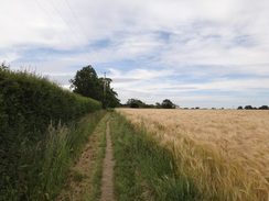
Turn left to follow Chappel Road east-southeastwards; after half a mile it ends at a T-junction with another road to the north of Fordham. Turn right down this road to head towards and through the village, eventually passing Fordham Church at TL927280. Continue carefully south along this road as it leaves the village; soon an off-road footpath is reached on the left, which provides a traffic-free route. This path diverts to the left to avoid a house; it skirts the house and passes through an intermittent hedgeline before reaching a T-junction with another path at TL928272.
For the next few miles, this route follows the Essex Way. Turn left to follow the intermittent hedge on the left and a fence on the right. After a short distance the path curves to the left to follow a fence on the left. At the end of the field it crosses a footbridge over a ditch and curves slowly to the right, still following a fence on the left before reaching a footbridge over the river on the right at TL933275. Turn right towards the footbridge but do not cross it; instead, at the bridge turn left and cross a plank bridge over a ditch. The path parallels the northern bank of the River Colne, crossing a plank bridge with scrubland to the right.
Go through a metal gate into a field and continue on with a hedge to the left. Near the end of the field, turn left through a gap in the hedge. On the other side turn right to head towards the far left-hand corner. Before it reaches the corner it curves to the right and joins a rough track that heads towards a broad gap in the hedge ahead; there is a concrete bridge over a stream in the middle of the field. Continue along this track through the next long field; it passes a ruined brick building on the left and then curves left to reach a pedestrian gate beside a field gate.
Go through the gate and continue along the track, which soon curves to the right and climbs on a more easterly course. This passes between barns at Cook's Hall to reach a track junction. Take a track that angles off to the left, which soon joins another track coming in from the right. Follow this track north-northeastwards for a fifth of a mile; it curves slightly to the left and then the right; at the left-hand curve head straight on along a footpath with a hedge and the track on the left, crossing a stile on the way. This passes some ruined and overgrown barns on the right before turning left and crossing a stile and plank footbridge to rejoin the track near West Bergholt Hall. Continue along the track towards West Bergholt church at TL953280.
With the church to the left, turn right along a track towards some barns. After a few yards turn right and then left to join a footpath that follows a hedge on the left, with the track on the other side. At the end of the first field go through a gap in the hedge in the corner of the field, and then follow the path as it runs between two fields. As the path forks, take the left-hand branch to continue in a more easterly direction between two fields. Go through a hedge at the end of the field and walk between hedges to reach the end of a road called Firmins Court. Cross this and continue on between fences until the path ends at Lexden Road at TL958279.
Carefully cross the road and then turn right down the road for a few yards, and then left down New Church Road. This soon curves to the right to take a more southeasterly course, passing the eponymous new church before it ends at a T-junction with Chapel Road. Turn left along this road and follow it for a sixth of a mile until it ends at a mini-roundabout with the B1508 Colchester Road at TL965277. Carefully cross the road and turn right down it, before taking the first road off to the left, Armoury Road. This soon curves to the right to take a more easterly course, passing houses on the left.
The houses end and the road carries on. Just before a farm is reached turn left along a track, keeping the farm buildings on the right. As the track curves to the right towards a bungalow, continue on along a footpath to reach the corner of the field. Curve slightly to the right through a gap in the hedge ahead to continue northeastwards with a hedge on the right and a field on the left. When the hedge curves to the right after about 150 yards, turn left to join a footpath that heads northeastwards across the centre of the field. This descends to cross a footbridge over a stream and then goes through a hedge to enter another field.
Continue straight on up the middle of this field. The path crests the small hill and heads on towards a gap in the hedge ahead. Once through the gap, turn left and then half-right to head diagonally across another field. When this reaches a fence, turn left to follow the fence with an orchard on the left until the path ends at a junction with a surfaced path at TL976288. Turn right down this track and follow it northeastwards for 0.4 miles until it ends at a T-junction with the A134 road at TL982291.
Here the Essex Way is left behind. Turn right to follow the A134 southeastwards; after a third of a mile it passes under the A12(T) and heads on towards Colchester. When a roundabout is reached, take the second road on the right, Nayland Road, which leads south. Continue along this road for another mile until a large roundabout is reached just before a railway bridge; take the second road to the right which leads up towards Colchester railway station at TL990264.
 |
 |
|
Distances
| From | To | Distance (m) | Ascent (ft) | Descent (ft) |
|---|---|---|---|---|
| Sudbury station | Bures | 7.5 | 591 | 620 |
| Bures | Wormingford | 2.3 | 207 | 95 |
| Wormingford | Fordham | 4.0 | 108 | 118 |
| Fordham | Colchester station | 7.0 | 233 | 331 |
This makes a total distance of 20.8 miles, with 1139 feet of ascent and 1164 feet of descent.
For more information on profiles, ascents and descents, see this page
Transport
Frequent train services run between Manningtree and Sudbury; you need to change for the Sudbury branch at Mark's Tey station. On some services you will need to change at Colchester as well. The journey takes between 40 and 60 minutes. See the National Rail Enquiries website for more information.
 |
 |
|
 |
 |
|
 |
 |
|
 |
 |
|
 |
 |
|
 |
 |
|
 |
 |
|
 |
 |
|
 |
 |
|
 |
 |
|
 |
 |
|
 |
Disclaimer
Please note that I take no responsibility for anything that may happen when following these directions. If you intend to follow this route, then please use the relevant maps and check the route out before you go out. As always when walking, use common sense and you should be fine.
If you find any information on any of these routes that is inaccurate, or you wish to add anything, then please email me.
All images on this site are © of the author. Any reproduction, retransmissions, or republication of all or part of any document found on this site is expressly prohibited, unless the author has explicitly granted its prior written consent to so reproduce, retransmit, or republish the material. All other rights reserved.
Although this site includes links providing convenient direct access to other Internet sites, I do not endorse, approve, certify or make warranties or representations as to the accuracy of the information on these sites.
And finally, enjoy your walking!
Nearby walks
| # | Title | Walk length (miles) |
|---|---|---|
| 270 | Brightlingsea to Fingringhoe | 15.2 |
| 271 | Fingringhoe to Tollesbury | 16.7 |
| 630 | Braintree to Marks Tey | 14.4 |
|
|

|