Walk #950: Stour Valley Path: Bures to Manningtree
 |
 |
|
General Data
| Date Walked | 28/05/2012 |
| County | Suffolk, Essex |
| Start Location | Bures railway station |
| End Location | Manningtree railway station |
| Start time | 07.56 |
| End time | 15.57 |
| Distance | 21.0 miles |
| Description | This was a pleasant walk following the Stour Valley Path downstream reaches of the Stour. |
| Pack | Today I carried my 30-litre Karrimor rucksack, filled with water, my waterproofs, a book and other odds and ends. |
| Condition | I slightly twisted my left ankle during this walk, and this caused me some discomfort during the rest of the day. Aside from this I feel elated, bouyed up by good weather and some picturesque riverside walking. |
| Weather | Today was hot; very hot for the time of year. There were scarcely any clouds in the sky all day until the very end; fortunately I escaped before the torrential downpours began. Another hour and I would not have been so lucky. |
| OS map | Landranger number 155 (Bury St Edmunds, Sudbury & Stowmarket) and Landranger number 168 (Colchester, Halstead & Maldon) |
 |
 |
|
Map of the walk
Maps courtesy of Google Maps. Route for indicative purposes only, and may have been plotted after the walk. Please let me have comments on what you think of this new format. For a detailed table of timings for this walk, please see the table file.
 |
 |
|
Notes
My last walk alone the Stour Valley Path had taken me as far downstream as Sudbury, but I was now left with a problem. The trailhead at Manningtree was 26 or 27 miles away; much farther than I really wanted to stroll today. Additionally, I had walked the six miles south from Sudbury to Bures before. As both Bures and Manningtree have railway stations, I decided to do this section first.
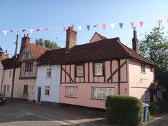
The drive down to Bures was easy enough, although slowed by being trapped behind lorries all the way from Bury St Edmunds. Bures was in full fete mood for the Queen's jubilee and long strings of bunting swayed in the wind. It was a relief to find that the car park at the railway station was not only free, but also that there were a couple of spaces left.
I must admit to liking Bures. It was not as picturesque as some of the Suffolk villages in the area, but it felt atmospheric, although that might just have been the effect of the bunting. I walked along the road through the village, passing gaggles of children waiting for school busses, and joined the trail. I went wrong almost immediately - choosing to head across a playing field rather than taking the official route along the road. It was not a major problem as the paths rejoined after a couple of hundred yards.
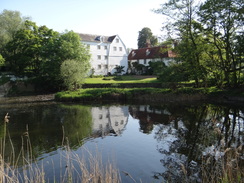
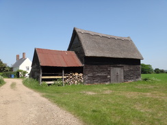
It was promising to be an exceptionally hot day, and I slavered on the first layer of suntan lotion as I ambled towards Bures Mill. The white clapperboards of this building almost seemed to glow in the sunshine, and I diverted slightly off the path to try to get a better photo of it. I was soon spotted by an inhabitant, who politely told me the way onto the proper path!
After crossing the river, the path crossed fields on the floodplain to reach a large new building that was under construction. This seemed to have a rather classic design for the area, although the lack of windows pointed at some form of industrial use. A sign a little further on told me that it was a new sewage pumping station, and I admired the way they were following the old tradition of grand waterworks buildings.
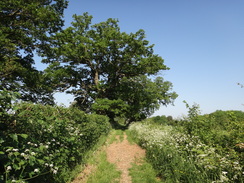
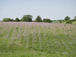
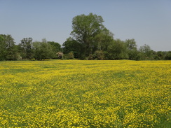
The first climb of the day took me up the Lodge Hills and past the compact Wormingford church. More paths and a track took me eastwards and I revelled in what were perhaps the best views on the trail so far, with expansive vistas off to me left. True, they were not as grand as you get elsewhere in the country, but they had a certain appeal, especially as such views are not common on riverside trails. Two large television transmitter masts at Workhouse Green were clearly visible in the distance, and would remain so for much of the day.
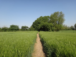
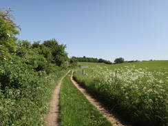
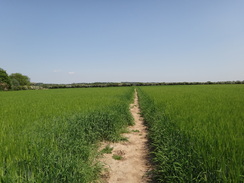
Eventually I came across a gaggle of walkers who were resting beside a hedge. They were from Holland, and were walking the E2 route across Europe in stages. So far they had done over 1,000 miles of the route and seemed to be enjoying it, and especially Britain's comprehensive network of footpaths which they praised to the heavens. They warned me that the next bit of the trail back down onto the floodplain was tough, and it turned out to be all too true. The farmer had left a wide path through the plants that grew to nearly my head-height, but many had fallen into the gap. This meant that the area up to my knees was generally clear, whilst the rest of my body had to force its way through. At times it was like swimming through a pea soup, and proved to use much more energy than I wanted.
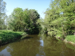
It was a relief when the two fields ended and the trail recrossed the Stour near Wiston Mill. Here it also rejoined the St Edmund Way, which would follow the same route for almost the entire rest of the day. The path flirted with the Stour at the bridge before angling off across the floodplain, sadly leaving the river out of view. A fairly pedestrian stretch of path took me to a main road in Nayland, a walk livened up by four prop-driven planes flying low overhead in formation.
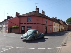
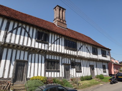
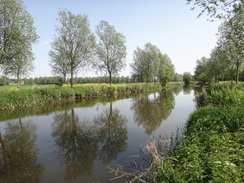
The next stretch of path followed the southern bank of the river past Nayland, and this turned out to be a wonderful stroll alongside the river. Expensive-looking houses flanked the other bank, and the combination of sunshine and lush vegetation made it a heavenly spot. Things got even better when the trail left the river and headed through the village, which was filled with some wonderful half-timbered buildings. Beside the church was a little obelisk that marked the distances to various places, including London.
After passing one particularly interesting-looking half-timbered building that did not seem to have a single straight line in it, the trail climbed once more back uphill following a road. Eventually the road was left behind and a track diverted downhill, the tall trees on either side thankfully blocking off the worst of the sun. A little later it joined another track, and here I slightly twisted my left ankle. Cursing, I tested my weight on it and continued on as pain shot up my leg.
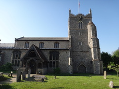
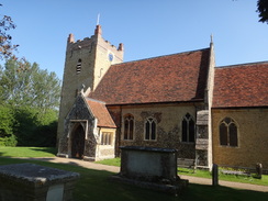
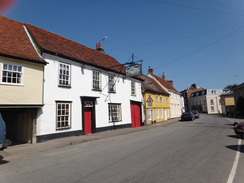
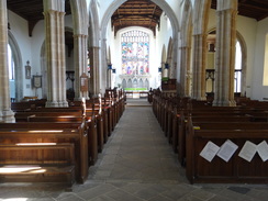
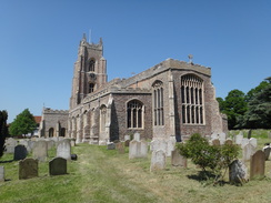
It was a relief when the little village of Stoke-by-Nayland was reached. I passed the rather large church and, as the door was wide open, I nipped in. The interior was a treasure - the narrow nave and tall roof made the interior feel somewhat like an undersized cathedral, and there were numerous other objects to see, including several well-carved tombs. It is the sort of church that I love to find whilst I am out and about walking, and was filled with little treasures.
Eventually I tore myself away from the church and followed the path into the village proper. I passed a pub that appeared to be closed, but another a few yards down the road was open. I went in, shrugged off my rucksack and ordered a bitter shandy. My left ankle and leg were aching a fair bit by now, and I dared not take my boot off. Instead I tried to rest my foot in a way that caused least discomfort whilst I considered whether I would be able to complete the walk.
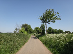
The rest did me good, not the least because I was out of the sun, and eventually I decided it would be best to continue on. The routes of the St Edmund Way and Stour Valley Path diverge for a short distance through the village, and it was unclear on the map which was the correct route. In the end I chose the wrong one, and had to head back to rejoin the proper route. The path skirted behind some gardens before climbing uphill and descending to reach a farm. Another climb then followed, and a rather pedestrian stroll along paths and green tracks took me eastwards, before curving south to reach the B1068 near Thorington Street. It was a fairly pedestrian stroll with few positive or negative points; in the growing heat I just put my head down and walked.
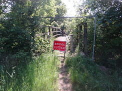
Another green track took me south to reach the Stour once more at a bridge over the river. A sign on the ground near the road had said that the footpath was diverted, but that notice had run out in the middle of last year. However when I reached the bridge I found a fence barring access and a sign stating the bridge was closed. A quick glance at the map showed that there was no obvious diversionary route aside from along the main road. However a couple of lads were standing on the bridge; they were topless and soaked after jumping into the river below. Assuming that if it was safe for them, it was safe for me, I crossed the bridge. They asked me if I was 'someone in authority'; assuming I was about to give them a telling-off for being on the bridge. After assuring them that the bearded, scruffy and sweaty man in front of them had no authority at all, I continued on.
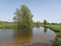
A fairly ordinary stretch of path took me across the Stour's floodplain once more, eventually skirting the river before crossing it on a bridge to reach a road in Stratford St Mary. Here I met a very fit-looking woman with peroxide-dyed hair who was pushing a bike along the road. She spotted my map and asked me if I could tell her of a footpath to East Bergholt as she had a flat tyre; we studied the map and judged that there was no good route that avoided the dual-carriageway A12. I left her to head towards the pub, presumably to ask for help, before heading through a tunnel under the dual carriageway to join a path that followed the northern bank of the river.
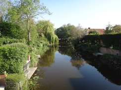
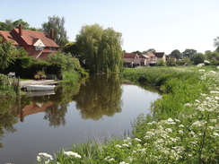
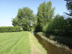
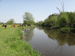
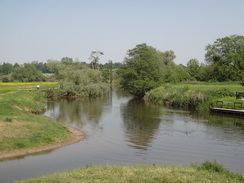
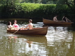
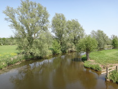
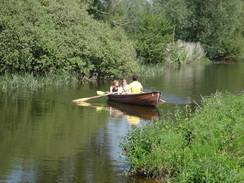
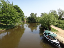
This was perhaps the longest stretch of riverside walking on the entire trail, and the water looked glorious in the bright sunshine. I was starting to wilt by now, and I was glad that I had refilled my water bottle at the pub. After passing near to Dedham Mill, the trail reached Dedham Bridge. There was a pub on the other side of the bridge and many people seemed to be enjoying the sunshine. Some wooden rowing-boats were lined up below the pub's decking, and it seemed like a perfect occupation for such a warm afternoon.
As I walked on I discovered other people had had the same idea, and many rowing boats were going to and fro along the river. One young lad was topless and rowing with strong strokes to impress the two girls in the boat with him. Sadly he was rather outshone by a young woman whose strong, professional strokes were not only more effective, but also looked far more fluid and effortless.
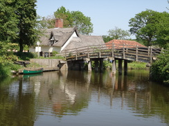
The trail headed away from the river for a short distance before crossing a footbridge over the river to reach the southern bank. On my map the footpath followed the riverbank as it twisted and turned, but this route was slightly overgrown and a much more direct path was being walked by people out enjoying the sun. I decided to take the latter route, and soon crossed a footbridge to reach Bridge Cottage at Flatford Mill.
This mill is famous for its connections with John Constable, and the cottage is now a National Trust property. I nipped into the shop but found they did not sell ice cream, and so I headed down the road past the mill and then along the trail. The next stretch was a little let-down after the superb riverside walking I had just done, and made slightly worse by a boggy expanse of ground that was the only mud I saw all day. It was a relief when the trail reached a road, which was then followed down towards Cattawade.
A little car park just before the A137 road marked the downstream trailhead of the Stour Valley Path, and I nipped in to ensure I reached the very end of the trail. I found a waymarker pointing back the way I had come, then headed down to a portage slip by the river before climbing up a bank onto the main road. Here I joined the route I had walked on my coastal walk, and I strolled over White Bridge, which is now a tidal barrier that prevents saltwater from reaching as far upstream as Flatford Mill. Memories came flooding back as I strolled along, and I felt a sudden urge to change my route and head along a path to Manningtree and Mistley, two places that held fond memories from that previous walk.
After a few moments prevarication I decided against this, and on the other side of the bridge I left the route of my Coastwalk behind and continued along the main road to reach Manningtree Station. A train to Marks Tey arrived after a few minutes, but this meant that I had a long wait at Marks Tey for a train on the branch back to Bures. Fortunately a little cafe was open and I munched on a delicious pain au chocolat as I waited in a shaded spot. It had been an enjoyable day's stroll, although any satisfaction at having completed the Stour Valley Path was slightly tempered by the fact that I have not walked the Sudbury to Bures stretch as part of this campaign. That will have to wait for a future walk.
 |
 |
|
Directions
This walk starts off at Bures railway station at TL903339. Descend from the station through the car park, then turn left and immediately right to reach Station Hill. Turn right down this road, and follow it as it heads eastwards to reach a T-junction with the B1508 road. Here it joins the Stour Valley Path, which will be followed for the next few miles.
Continue straight on and follow the B1508 as it crosses the River Stour and passes Bures Church on the right. As the road swings to the left immediately after the church, turn right down Church Square, initially keeping the church on the right. The road curves to the left and then right to head east-northeastwards through the village. Pass a car park, a community centre and then a house on the right; immediately after the house at TL909338 turn right through a pedestrian gate to enter a field. Head diagonally across the field to reach another pedestrian gate beside a field gate. Go through the gate to reach a track.
Turn right down this track and then immediately left to head down the driveway that leads towards Bures Mill. Cross a stile beside a gate and continue on along the track. It curves to the right towards the mill; immediately after the bend turn right along a path that follows a hedge on the left. This squeezes past the mill complex on the left and then curves to the right to head towards a footbridge over a sluice on the Stour. Immediately afterwards the path crosses a little stream to reach a pedestrian gate that leads into a field at TL910334.
Turn half-left to walk southeastwards across the field whilst the river curves away to the right. At the hedge cross a stile into a second field and continue on to a second stile that leads into a third field. Continue straight on across this long field as the river comes in from the left; at the end cross a third stile and a footbridge over a ditch to reach the narrow fourth field. Head across this to another footbridge over a ditch that leads into a fifth field.
Cross a spur of the field to join a hedge on the left; follow this to reach the far left-hand corner of the field. Go through a gap in this hedge and turn slightly to the right across a sixth field to reach a track running alongside the corner of a hedge at TL919329, with a newly-built (2012) waterworks building to the left. Turn right down the track for a few yards, then left to follow a hedge on the left to reach the far corner of the field. Go through a gap in the hedge at the corner to reach another field, and then turn half-right to head across this on a slight diagonal, aiming for a large bunch of trees ahead. Before these are reached cross a track and a footbridge across a stream to enter another field. Head across a spur of the field and skirt some trees that hide Wormingford Mere on the left. As the trees curve away to the left continue straight on uphill across the field, aiming for a large tree ahead.
Pass the tree on the right to reach a clapper gate; on the other side turn half-right to climb up a steep hillside to reach another clapper gate through a fence that leads into a rough field. Head straight on across this field, and in the far corner go through another clapper gate. On the other side turn half-left to follow a fence on the left; initially the path is flat, but it then descends a slope to reach an area of woodland. It climbs up through the trees, cresting a slight hill before falling. Go through a clapper gate to emerge out of the trees into the graveyard of Wormingford Church. Turn left to join a path that curves to the right, passing the church on the left to reach some steps beside a gate on the right. Ascend these steps over the wall and down the other side to reach a road in Wormingford at TL933322.
Turn left to head north along the road for a short distance, then take the first surfaced road off to the right. As the road curves to the left towards a school, continue straight on across a grass path to reach a clapper gate that leads into a field. Follow the path as it runs across the middle of a field until it reaches a hedge. Turn left to follow the hedge on the right, which curves to the right to reach a stile and field gate through a hedge. Continue following the hedge on the right to reach a field gate just before a cottage, then pass the cottage on the left at TL938323. Here the path joins a track. Do not follow the track as it curves to the right, but continue straight on to reach a clapper gate at the bend.
Once through the gate, follow a fence on the right downhill. As the fence starts to curve to the left, turn right across a stile and descend a slight slope to reach a plank footbridge over a ditch, then a second stile. Head straight on; as the fence curves to the left head straight across the field for about thirty yards, aiming for a clapper gate. Go through this, cross a footbridge and then another clapper gate to enter another field. Here turn slightly to the right to head uphill, aiming to meet a hedge on the left. Follow this hedge around to meet a clapper gate that leads onto a bend on a surfaced road at TL941321.
Turn left to start following the road eastwards. It soon curves to the left and starts dropping downhill. As it curves to the left once more at the bottom after 0.4 miles, turn right to join a footpath that follows a rough track. This initially heads through an area of woodland. It emerges out of the trees and follows the edge of a field on the right. It soon passes a pond on the left; the pond soon becomes a stream. At the end of the pond turn left to cross a bridge over the stream, and then immediately right to continue on with a fence on the left.
The path becomes a track that heads uphill. As the track curves slightly to the right, turn left across a stile and head uphill across a paddock. Cross a stile and pass the end of a track coming in from the right before following a fence on the left, with Malting Farm away to the right. As the fence turns to the left, squeeze through a gap in a hedge ahead and continue on with a hedge on the right. At the end of the field go through a wide gap ahead and continue on with a hedge on the right. The hedge soon turns right; a few yards further on go through a gap in a hedge ahead and across a plank footbridge over a ditch to reach a bend in a road at TL951319.
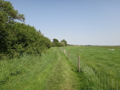
Turn left and follow the road eastwards. After a couple of hundred yards turn left up four steps to reach a field, then turn right through a hedge. On the other side turn left to follow a hedge on the left northwards. At the end of the field continue on past a hedge on the right, then turn right to follow the hedge on the right eastwards. At the end of this field cross a surfaced track (School Lane) and continue along another footpath, following a hedge on the left. After about 250 yards look out for a gap in the hedge, then turn left through the hedge into another field. Follow this path downhill to the north.
At the bottom of the field cross a footbridge over a deep ditch and follow the path as it curves slightly to the right. Cross a little bank at the northern end of this field and go down a few steps to reach a bridge over a ditch. The path passes through an overgrown area to reach a footbridge over a stream. It then reaches a footbridge over the main River Stour at TL958331.
Cross the bridge, and on the other side turn right to follow a footpath eastwards. Soon a hedge starts on the right; continue on to cross a track leading to Wiston Mill. When the hedge curves to the right continue straight on following a ditch on the right. At the end of the field cross a footbridge over a stream and continue across an area of grassland. When this ends, squeeze past a hedge on the left to follow a ditch on the right across more grassland. Cross a stile and a footbridge across a ditch, then head on, still following a ditch on the right. Go through a field gate through the next hedge as buildings in Nayland become visible ahead. The path curves to the left; in the corner of the field go through a clapper gate to join Wiston Road. Turn right down this road for a few yards to reach the A134 road at TL967342.
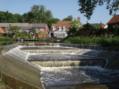
Turn right and carefully follow the A134 southeastwards; when possible, carefully cross the road to reach the other carriageway. Continue on across a bridge over the Stour, and on the other side turn left along a footpath down a slight slope to join a footpath. This follows the Stour on the left and winds around. It passes a weir on the left; after nearly half a mile Nayland Bridge is reached. Climb some steps onto the bridge, then turn left to cross the river. Continue along the road as it heads northeastwards through the picturesque village of Nayland, passing the church on the right before curving to the left and ending at a T-junction with the B1087 road at TL974343.
Turn right along the B1087 for a short distance, then turn left up a road called Gravel Hill. Follow this road as it heads uphill, the gradient soon slackening. As the road curves sharply to the right after 0.6 miles, turn left to continue straight on along a footpath that runs between hedges. It slowly descends to cross a stream on a field bridge before reaching a stile. Cross this and follow a fence on the left. At the top of this field go through a field gate beside a clapper gate and head on, with a field boundary on the left. When the fence on the left turns away to the left, turn half-right to head diagonally across a field, aiming for a clapper gate in the hedge ahead. Go through this and continue across another field to reach a stile and some steps to reach a sunken track at TL971362.
Turn right and follow this track as it climbs and falls; after a third of a mile it reaches a bend in a surfaced road. Turn left along this road, and as it curves away to the left, turn right down a surfaced lane. It passes Poplar Farm on the right, and when the track forks take the left-hand branch to follow a rough track. This climbs and curves left and right; as the track curves to the left half a mile after leaving the road, continue straight on towards a church tower. Go through a pedestrian gate and pass a wall on the right before the path ends at a road in Stoke-by-Nayland at TL985362.
Turn right down the road; after a few yards turn left along a gravel path with the churchyard wall on the left, and then turn left to take a path that heads eastwards, passing Stoke-by-Nayland church on the left. This path emerges from the churchyard onto Church Street. Head straight on down this road until it reaches the B1087, and then turn left along this road for a short distance until it ends at a T-junction with the B0188 next to the Angel Inn.
Turn right to follow the B1088 southeastwards, passing the Crown pub on the left. After a fifth of a mile go through a clapper gate on the left and follow a hedge on the left north-northeastwards. Eventually the hedge curves slightly to the right to reach a corner of the field. Turn right and follow the path southeastwards along the northern edge of the field. Go through a clapper gate at the corner of the field and continue across an area of scrubland. When this ends after a short distance, go through a second clapper gate to enter a field. Turn half-left to head across the field; go through a third clapper gate and continue on with a fence on the right.
Cross a stile at the end of the field and continue on with a fence and hedge on the right. Cross a stile beside a field gate and continue on for a few yards to reach a track. Join the track and follow it past Valley Farm on the right; here turn left along another track that immediately crosses a bridge over a stream and climbs uphill. When the track forks in front of a house at Rams Farm, take the right-hand branch for about five yards, then turn left to reach a stile. Cross this and head on between fences to a second stile. It heads uphill to reach a third stile on the left. Cross this and continue through widely-spaced trees; it emerges from these and follows a hedge on the right until it reaches a track called Londs Lane at TM007363.
Cross the track and continue along a path that follows a hedge on the right. At the end of this field go through a gap in a hedge ahead to reach a road called Hudsons Lane. Turn right down the road for about ten yards, then left along another path, still with a hedge on the right. The path becomes a track that curves slightly to the right; when it ends at a T-junction with a better track, turn left to follow the new track northwards, immediately passing Bobwrights Farm on the right. This track curves to the right and the left before reaching a junction with a surfaced track at TM012368.
At the junction, turn right down the other track. As it curves sharply to the right after a fifth of a mile, turn left along a green lane that runs between hedges. Follow this as it initially heads eastwards, before curving to the right to take a twisting southerly course. After nearly a mile, it ends at a junction with the B1068 road at TM018355.
Turn left to follow the B1068 eastwards for a short distance, before turning right down a track called Langham Mill Lane that follows a hedge on the right. After 0.4 miles this curves sharply to the right and then the left, to continue on in a rough southeasterly course. The track becomes more indistinct and the land becomes scrubbier; it crosses a footbridge over a stream next to a ford and heads on through some sparse woodland to reach a footbridge over the Stour at TM025344. Note that in 2012 this bridge was closed awaiting repair; there is no convenient alternative diversion. It would be a good idea to check the status of the bridge before attempting this section of the trail.
Continue along a track on the other side of the bridge, passing a house on the right. As the track curves to the right turn left down a footpath which runs across the middle of a field. Go through a gap in the hedge at the eastern end of the field and continue across a second field; the path emerges out onto a track immediately to the south of the farm at Broomhouse. Continue along the track for a few yards; as it curves to the right across a ditch, turn half-left to follow a path around the edge of a field. This soon curves to the right and passes a small lake on the left, which is soon replaced by the Stour. The path passes a sandy strip on the right; a horse-exercising area.
As the sandy strip curves sharply to the right turn left through a gap in a hedge, and then turn right to join a path that runs along the southern bank of the Stour. As the path curves to the right, head straight on along a grassy path with the river still to the left. Cross a stile and then turn slightly to the right to head diagonally southeastwards across a large field. At the end of the field, cross a stile to reach a footbridge over a sluice on the Stour. A track leads on for a short distance until it ends at a T-junction with The Street in Stratford St Mary at TM042340.
Turn right and follow The Street southwards, passing the Black Horse pub on the left. Just before a bridge over the Stour is reached after a third of a mile, turn left through a little car-parking area to reach a clapper gate. Go through this and follow a track that heads through a tunnel under the A12(T). The track curves to the left after emerging from the tunnel; here continue straight on to reach a clapper gate that leads into a field. Simply follow the northern bank of the Stour as it twists eastwards, going through whatever gates you meet on the way. After a mile it passes Dedham Mill on the other side of the river and goes through a clapper gate before climbing up onto the B1029 road beside Dedham Bridge at TM058336.
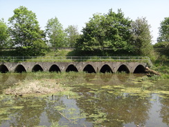
Carefully cross the road and turn left to follow it northwards for a few yards. Immediately after it crosses a stream on a bridge, turn right through a wooden clapper gate to rejoin the northern bank of the Stour. Follow the Stour for a sixth of a mile; the river curves to the right and the path forks. Take the left-hand branch that heads east across a field. At the end of the field go through a clapper gate to join a rough track that heads eastwards between hedges. When this ends at a junction with another track, turn right to head south between hedges to reach a clapper gate that guards Fen Bridge over the Stour at TM067335.
Cross Fen Bridge, and on the other side turn left down some steps and through another clapper gate to start following the southern bank of the river southeastwards. The path passes through a gap in a hedge and curves to the right and then left. The path is easy to follow on the ground as it crosses the floodplain with the river to the left. After two-thirds of a mile it reaches a bridge over the Stour. Go through a clapper gate, then cross the bridge and head up a track to reach a road by Bridge Cottage at TM075333.
Turn right to follow this road southeastwards for 250 yards; after passing Willy Lott's Cottage on the right, the track curves to the left to run northeastwards between hedges. When the track reaches a farm gate ahead, turn right to follow a wide path that runs between hedges. After a while turn left off this track to reach a clapper gate that leads through a hedge. On the other side turn right to follow a fence on the right. The path passes under power lines then curves to the right to pass a large pylon. Go through a clapper gate in the corner of this field and turn left, following a hedge on the left. At the end of this field it squeezes through a gap in the hedge ahead and continues on, still following a hedge on the left.
It squeezes past another hedge and continues eastwards; in places the going is boggy. At the corner of the field go through a clapper gate and head on, following a fence on the right. Ignore a path leading off to the left, and follow the fence to reach a clapper gate. The path passes through an overgrown area and crosses a boardwalk before curving to the left and right to follow a hedge on the right, with a field off to the left. This path soon goes through a large gap in a hedge ahead to end at the B1070 road at TM094334.
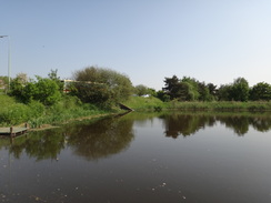
Turn right to follow the B1070 southeastwards; when it curves to the left after a third of a mile, turn right down a dead-end road that leads to a car park on the right in Cattawade at TM100331. This car park marks the eastern end of the Stour Valley Path.
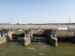
To continue on to Manningtree railway station, leave the car park and climb up the bank to reach the A137 road. Follow this road south; it crosses a bridge over a small tributary of the river before reaching Cattawade Bridge over the Stour, with some large tidal sluice gates off to the left. When the road forks, carefully cross the road to reach a bridge under the railway line. Pass through this and immediately turn right along another road. This leads up to Manningtree railway station at TM093322.
 |
 |
|
Distances
| From | To | Distance (m) | Ascent (ft) | Descent (ft) |
|---|---|---|---|---|
| Bures | Womingford | 2.7 | 217 | 138 |
| Wormingford | Nayland | 4.5 | 203 | 322 |
| Nayland | Straford St Mary | 8.3 | 545 | 577 |
| Straford St Mary | Manningtree station | 5.6 | 95 | 92 |
This makes a total distance of 21.1 miles, with 1060 feet of ascent and 1129 feet of descent.
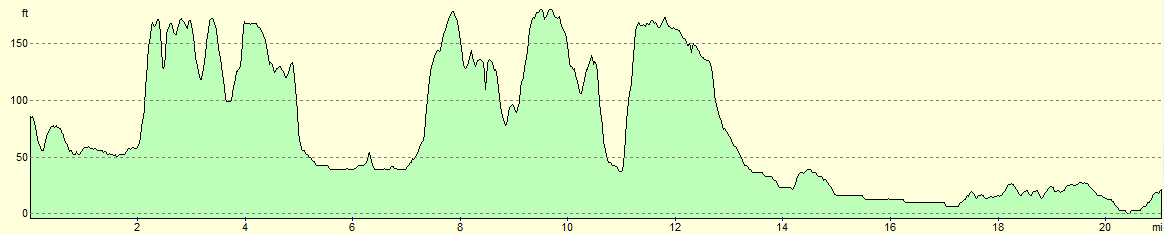
For more information on profiles, ascents and descents, see this page
 |
 |
|
Transport
Frequent train services run between Manningtree and Bures; you need to change for the Sudbury branch at Mark's Tey station. On some services you will need to change at Colchester as well. The journey takes between 40 and 60 minutes. See the National Rail Enquiries website for more information.
 |
 |
|
 |
 |
|
 |
 |
|
 |
 |
|
 |
 |
|
 |
 |
|
 |
 |
|
 |
 |
|
 |
 |
|
 |
 |
|
 |
 |
|
 |
 |
|
 |
 |
|
 |
 |
|
 |
Disclaimer
Please note that I take no responsibility for anything that may happen when following these directions. If you intend to follow this route, then please use the relevant maps and check the route out before you go out. As always when walking, use common sense and you should be fine.
If you find any information on any of these routes that is inaccurate, or you wish to add anything, then please email me.
All images on this site are © of the author. Any reproduction, retransmissions, or republication of all or part of any document found on this site is expressly prohibited, unless the author has explicitly granted its prior written consent to so reproduce, retransmit, or republish the material. All other rights reserved.
Although this site includes links providing convenient direct access to other Internet sites, I do not endorse, approve, certify or make warranties or representations as to the accuracy of the information on these sites.
And finally, enjoy your walking!
Nearby walks
| # | Title | Walk length (miles) |
|---|---|---|
| 266 | Shotley Gate to Mistley | 14.2 |
| 267 | Mistley to Great Oakley | 18.0 |
| 270 | Brightlingsea to Fingringhoe | 15.2 |
|
|

|