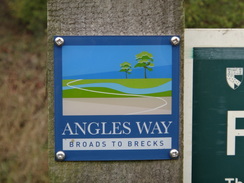
Walk #933: Angles Way: Diss to Bungay
 |
 |
|
General Data
| Date Walked | 21/10/2011 |
| County | Suffolk, Norfolk |
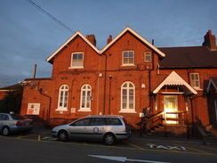
| Start Location | Diss station |
| End Location | Bungay Buttercross |
| Start time | 07.47 |
| End time | 16.48 |
| Distance | 24.7 miles |
| Description | This walk follows the Angles Way northeastwards from Diss, heading through Harleston before reaching Earlsham. It then leaves the trail for the mile's walk into the town of Bungay. |
| Pack | Today I carried my 30-litre Karrimor rucksack, filled with water, my waterproofs, a book and other odds and ends. |
| Condition | I had some potentially significant trouble with my left knee today; it ached for most of the walk and at times felt like it was seizing up. This led me to limp slightly, which also increased the strain on my bad ankle. I am going to have to take care of this knee over the next few walks... |
| Weather | The day started cloudy, but a slight breeze eventually blew this away, leaving a bright sky with thin, hazy clouds. The morning was not warm, but it improved during the afternoon. |
| OS map | Landranger number 144 (Thetford & Diss, Breckland & Wymondham) and Landranger number 156 (Saxmundham, Aldeburgh & Southwold) |
 |
 |
|
Map of the walk
Maps courtesy of Google Maps. Route for indicative purposes only, and may have been plotted after the walk. Please let me have comments on what you think of this new format. For a detailed table of timings for this walk, please see the table file.
 |
 |
|
Notes
Cabin fever was well and truly starting to set in after three weeks without a walk. I managed to arrange things so I had a free day today and by some miracle the weather forecast was also good, so everything was in place for a walk. The biggest problem with walking at this time of year onwards is the lack of daylight, and this meant that I was driving in the dark for the eighty minute drive to Diss to continue my stroll along the Angles Way. The parking at Diss station as rather extortionate - nearly five pounds for the day - but the station was the most convenient place for me to stop.
Since daylight would be a significant factor on today's long walk, I did not muck about and quickly got my kit together before heading off down the road. And the first half mile was exactly that - a road walk following the railway line northwards. I had walked this way two months before on my last walk along the Angles Way, and the foundations I had seen being dug were now nearly-complete houses; builders on large complexes do not hang about.
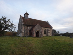
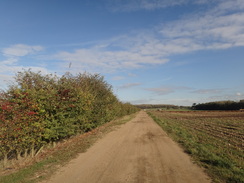
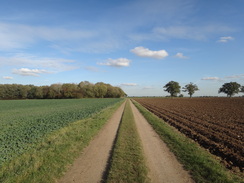
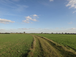
I soon joined the trail proper and started following it eastwards. It approached Frenze Hall before curving to the right, crossing a footbridge over a little stream to reach an attractive flint-built church with a little brick-built porch - this must have been related to the adjacent hall. After passing a small business park in the middle of nowhere, the path took tracks and path to reach Scole Common and then cross the A140(T). The trail does not enter the attractive little village of Scole itself which is a shame, and it was far too far away to countenance a diversion.
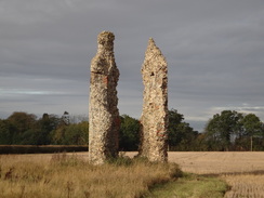
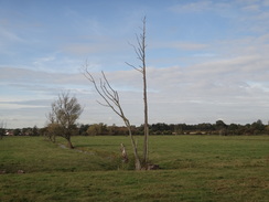
Paths took me across field before joining a road. Italicised text on the map marks the location of St Mary's Church (remains of)' and soon two skeletal fingers of flint appeared in a field to the right. These are all that remains of the round tower of the Thorpe Parva church, and they make quite an impact on the surrounding fields. I was surprised to find that the ruins are listed as there is virtually nothing left.
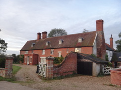
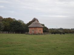
Another track took me up towards Hall Farm, and I was surprised to see another small church off to my right. St Leonard's Church seemed pretty through the trees although I was surprised how close it was to St Mary's Church; there is under half a mile between them and it is no wonder that one of them is ruined in such a rural area. A square, squat building stood alone in a field to the left near the farm, strangely away from any other buildings. I could not fathom what its purpose was; my best guess is that it is an old pumphouse, although it would be a strange one indeed.
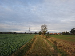
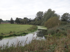
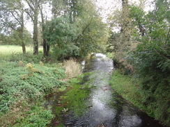
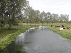
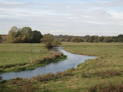
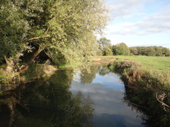
Soon afterwards the trail crossed a main road and joined the northern bank of the River Waveney for the first time today. The river is not wide and meanders around; as well it should, for it still has many miles to flow to the sea and it is only at 20 metres above sea level. Unfortunately the river only occasionally came into view through the trees to the right, but those glimpses were all pleasant. The trail followed the edge of the river's floodplain before heading back up to the main road and angling around into Brockdish.
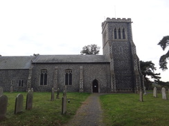
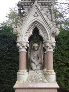
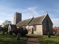
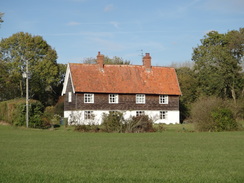
It soon passed the 11th-Century flint-built Brockdish church. I was tempted to go in for a look around, but in the end I just examined a rather magnificent memorial to the Kay Family in the churchyard; it was one of the best I have seen for some time with pinnacles, turrets and an exquisitely-carved angel. It was the sort of thing you expect to see in the centre of a market town's than in the corner of a quiet graveyard.
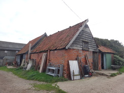
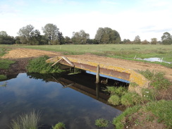
After leaving Brockdish the trail crossed to the southern side of the Waveney and started following the southern bank of the river northeastwards. It was a pleasant but fairly unremarkable stroll, with the flat river floodplain to the left and the gradual slopes of the valley sides to the right. It joined a road for a short distance before continuing on past a farm to eventually reach a footbridge over an old mill race, the water flowing violently down a slipway. A man was using a machine I had never seen before outside a rather grand house nearby: he was loading a hopper up with topsoil and the machine was sieving it, throwing out fine soil on one side and pebbles and stones on the other. Presumably the soil was going to be used as topsoil whilst the pebbles and rocks would be disposed of elsewhere.
A trail signpost beside the road near Shotford Bridge proclaimed Diss 12 miles, Bungay 12 miles', which meant that I was already halfway through my day. The trail skirted provocatively with Harleston, heading north past houses into the town before diverting off eastwards out of it. It never actually entered the centre of the town, missing it by just a couple of hundred yards. This was a shame as I wanted to stop off for a short break, but neither did I want to divert too far off the trail on what was going to be a long day's walk.
An old factory site marked on the map was now brand-new housing, with more being built. Another trail signpost beside the A143 confused me; it proclaimed Diss 12 miles, Bungay 12 miles', the same as the earlier sign a mile and a half away! This disconcerted me slightly as I was pressed for time slightly, although my GPS unit said that I had done well over twelve miles.
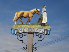
Further paths took the trail eastwards, crossing the Waveney and passing Mendham church before reaching the Sir Alfred Munnings pub in Mendham. This was open so I went in for a break. A pint of bitter shandy washed down a meal of ham, eggs and chips - much needed fuel for the remaining miles, especially as I was going to be very late home. The underside of my feet were really aching by now and I was very glad of the rest, and I ended up chatting to the friendly staff as I ate.
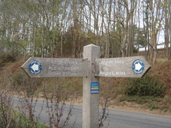
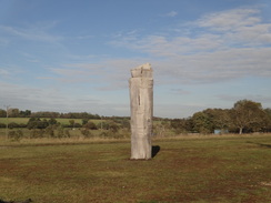
I did not spend too long in the pub and soon rejoined the trail. This headed northeastwards along a road before following paths that skirted the southern side of the Waveney's floodplain. It climbed before passing near to Holmersfield church before entering the small village. A wooden carved totem pole stood beside the B1062 outside the village; it was topped with a carved man sitting in a small bathtub-style boat, his hand lazily draped over the side. Around the base was written the village's name and I dreamed of a beautiful woman who carried me away'. It was an unexpected and rather beautiful discovery.
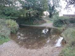
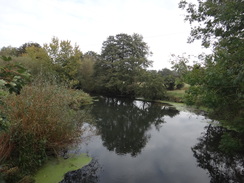
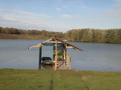
Sadly the next few hundred yards were a bit of a shock as the trail followed the busy A1062; the road was busy with lorries and I had to carefully pick my way along until a path led off to the right. This led past a rather beautiful lake; part of an old quarry. An unusual sign beside the lake proclaimed no digging' rather than the usual warning about deep water; I can only assume that they are worried about people trying to tunnel into the sand. Another pit was still in use nearby, and what looked like trial trenches were being dug on the other side of the path.
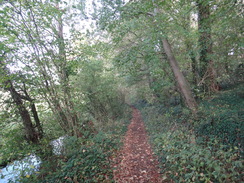
It climbed slightly away from the valley before heading along paths to reach the site of RAF Bungay. Although this went out of military use in 1955, civilian planes continued to use it until the runways were dug up in the 1980s. There was little trace of the airfield as I walked along the southern edge, but some old concrete taxiways were still intact on the eastern edge. I love walking around old airfields, even when little remains. There is something about the history of the places, the way that beautiful machines were flown by brave men for ugly purposes.
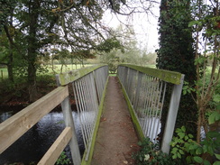
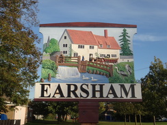
After leaving the old airfield, the trail headed down off the hillside into a valley. It crossed a small stream before reaching the Waveney once more. It crossed this on a rather long footbridge which led to a narrow footpath, with a stream below and to the right. This marked the entrance to the village of Earsham. I walked past the village pub and headed up to the A143, where I turned around and left the Angles Way for the day. I was extremely footsore by now and really wanted to get to the end of the day.
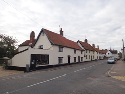
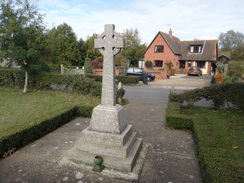
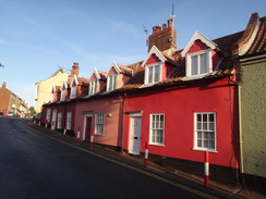
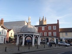
I had only missed a bus from Earsham by half an hour, but had ninety minutes until the next bus from Bungay. I therefore plodded along the road into the town, which was remarkably pretty. I was amused by the town's sign, which rather understatedly called it A fine old town' - it is a very fine place indeed. It did not take long to reach the grand Butter Cross in the centre of the town, by which time I still had an hour to wait for the bus.
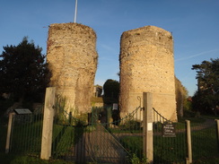
I didn't have a book with me for once and so I nipped into the nearby newsagents that was about to shut to buy a newspaper, then went to look at the castle. Access to this is through a cafe that was also about to shut, so I nipped around the side to take a photo of the ruins of the twin gateway towers - I will have to leave a visit to the castle proper for another time. Since there was still plenty of time left before my bus I went into a nearby pub and had a soft drink, but my wait was rather restless; I felt unhappy and uneasy for some reason.
The bus arrived promptly and it deposited me back in Diss just as it was getting dark. It had been a fairly anonymous day's walk; enjoyable but comparatively unremarkable after the rather stupendous walks I had done last month. I now have two days of walking left to complete the Angles Way, and I am keen to get these done soon.
 |
 |
|
Directions
This walk starts off from Diss railway station. From the entrance into the main station building, turn right until the southern edge of the building is reached, then turn left along the edge of the car park, with the car park to the left and the station buildings behind. Walk for a few yards to the side of the car park, then squeeze to the left of a billboard to reach a path. Follow this for a few yards as it twists to the right around some scrubland to reach the end of a road called Nelson Road. Turn left and follow the road as it heads eastwards for a couple of hundred yards until it ends at a roundabout with Sandy Lane. Carefully cross the road to join the pavement on the other side, then turn left to follow the road northwards. The pavement ends at a mini roundabout; continue straight on northwards along the road, passing some silos and a factory on the left before reaching a bend in the road at TM130802.
Here the Angles Way is joined. Do not follow the road as it curves to the left under the railway bridge, and instead turn right along a path. This soon passes a metal vehicle barrier and becomes a track that heads northeastwards between fields, sometimes open to the fields and at others enclosed by hedges or fences.
A third of a mile after leaving the road, the track passes a ford over a stream to the right; continue on with a fence to the left and the stream on the right to a footbridge. Turn right to cross the footbridge and up three steps on the other side. A path heads through a short band of scrub woodland, aiming for a small church ahead. The path emerges from the woodland onto a rough track; turn right and follow the track southwards as it becomes firmer concrete. Pass the church on the left and continue past some barns; half a mile after the church, the track ends at a bend in a road at TM136796.
Turn left to follow this road eastwards for about 150 yards, passing Diss Business Centre on the right. As the road curves to the left, turn right down a rough track. This immediately passes some houses on the right before curving to the left to take a more easterly course, passing under some power cables on the way. Initially the track is unfenced to the fields before becoming a narrower path between hedges.
Two-thirds of a mile after leaving the road, a junction with a footpath is reached on the left at TM146792. Turn left and follow this path as it heads north along the edge of a field, with a hedge to the right. At the end of the field turn left, still keeping the hedge to the right. After about 30 yards turn right through a gap in the hedge and cross a narrow ditch, then turn left to continue on with the hedge on the left (essentially crossing to the other side of the hedge). The path and hedge curve to the right at the western end of the field, and again at the northern edge. About fifty yards after the second bend the path curves to the left, crossing a ditch on a plank footbridge and entering some scrubland. After about thirty yards it emerges at a bend in a road at TM148798.
Turn right and follow the road as it heads eastwards; ignore a dead-end road that leads off to the right. After nearly half a mile it crosses a bridge over the A140(T) and ends at a T-junction with a minor road at TM154796. Cross the road and take a footpath that heads across a field, initially with a hedge and house on the left. When the hedge ends continue straight on across the field until it meets a gap in a hedge on the other side. Do not go through the gap and instead turn left, keeping the hedge on the right. Cross a bridge over a ditch at the end of the field and turn right for about ten yards to reach a stile over a fence. Immediately on the other side turn left to continue with a fence and hedge on the left.
At the end of this field turn right for about twenty yards and then left through a gateway. Continue diagonally across a field, keeping Thope Parva Hall to the left; the path joins a barbed wire fence that guards a pond to the right. Follow the fence for ten yards to reach a stile that leads onto a surfaced track. Turn right down this track, immediately passing Hall Farm Cottages on the left. Continue south along this track for a fifth of a mile; when it curves to the left with the skeletal ruins of St Mary's Church to the right, turn left down a track with a hedge on the left. At the end of the first field the track goes through a gap in a hedge, jinks to the left and then right before continuing with the hedge still on the left. It descends into a small valley before ending at a road at TM165791.
Turn left to head north along this road for a short distance, then turn right up a surfaced track that heads up a slight farm. The gradient slackens as it passes Hall Farm; after this the track becomes rougher as it continue eastwards for another 0.4 miles until it passes a vehicle barrier to end at a road at TM175792. Turn right and follow this road southwards for a fifth of a mile until it ends at the A143 road. Carefully cross the A143 and drop down into a track that parallels the southern side of it. Turn left to follow this track eastwards for 150 yards.
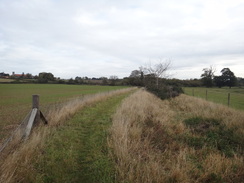
Just before a fenced compound is reached, turn right to cross a stile beside a field gate. This leads to a footpath that follows a rough track between widely-spaced hedges for a fifth of a mile until it ends at the northern bank of the River Waveney. Just before the river is reached, turn left to reach a plank-footbridge over a ditch. On the other side continue on with the field to the left and a hedge to the right, with the river on the other side of the hedge. The path continues east-sotuheastwards across a series of fields, passing through gaps in hedges between them.
When a fence is reached ahead at TM183782, turn left to follow the fence on the right away from the river. The pat curves to the left and then right across a plank footbridge over a ditch. Keep a copse to the right; when the copse ends keep a ditch on the right as it heads northeastwards. The path emerges out onto a track junction; take the major green lane to the right; this immediately curves to the left. Continue along this track as it heads between hedges; it cross a track at TM198787 before continuing on. It eventually emerges into a large gap between fields at TM200789; here turn left to follow a broad track that runs between hedges. This curves to the right and then the left, passing a barn on the right as it climbs gently uphill.
The track ends at the A143 road; just before the road turn right, keeping a hedge and the road on the left. This leads out onto a stretch of old road; follow this eastwards for 250 yards until it reaches a metal field gate. Squeeze past this to reach a bend in the B1134 road. Turn right and follow the B1134 eastwards towards Brockdish; after a short distance turn left down a track. Continue for ten yards past a couple of wooden gates, keeping a fence on the right. After a few yards turn right to parallel the main road below to the left.
The path skirts a chain-link fence on the right before going through a metal gate through the fence to reach the recreation ground on the other side. Turn left on the other side to cross the playing fields, aiming for the church. Squeeze past a field gate to reach the end of a road with Brockdish church immediately to the right. Continue down this road; after a couple of hundred yards it curves to the right to head southwards. Just before some houses are reached on the right, turn left down another footpath. This skirts the houses on the right before curving to the left with a copse on the right; it passes the copse and curves to the left once more, aiming for another copse a few yards away. It does not enter this copse and instead curves to the right, keeping the copse to the left. The copse soon ends and the path continues along a grassy band between fields. A hedge soon starts on the left as the path starts to head downhill, passing a little house on the right before crossing a concrete bridge over a ditch and ending at a T-junction with a road at TM210801, with a large road bridge to the left.
Turn right down a minor road for a couple of hundred yards, heading away from the road bridge. Pass a couple of 30MPH speed limit signs and then turn left across a stile to join a footpath that heads uphill. The path squeezes through a very overgrown area to reach a couple of stiles n quick succession, emerging from these into a field. Continue on with the field to the left and a hedge on the right. About two-thirds of the way up the field, turn right across a little bridge over a ditch. Continue on along a path with a field on the left and hedge on the right; these descend to reach a road in Brockdish at TM212797.
Turn right and follow the road southwestwards through the village, passing the King's Head pub on the left. Take the first road to the left, Common Lane, and when a house is reached ahead turn left down a track that soon leads into a farm. Follow the track as it curves to the right through the farm, passing two semicircular huts on the left. Cross a bridge over the River Waveney; on the other side of the bridge turn left through a metal gate and turn half-right along a footpath across a field. This meets a hedge on the right. Keep the hedge on the right as the path heads northeastwards.
At the end of the first field cross a stile over a fence and continue with a fence on the right. Cross a stile beside a field gate as the river approaches to the left. At TM220797 it crosses a plank footbridge over a stream and continues on with the river out of view to the left. The path heads through rough scrubland; when the scrubland ends at TM221799 it goes through a metal gate beside a wooden field gate and continue with the river to the left. Shortly afterwards go through another gate and head on across another field. At the end of this field cross another stile at TM224803 and head on with a fence still to the right.
It passes through a little copse and heads on across a field; when a reed-filled ditch starts, keep this to the left and head on towards a metal gate in the hedge ahead at TM226806. This leads into another field; keep the hedge on the left as the path heads northeastwards. It leads through a broad gap in a hedge into a second field; aim for a stile through the hedge at the end of this field. Cross this stile to reach a road at TM230809.
Turn left and follow this road downhill for a few yards; as it curves to the left turn right down a rough track that leads towards Instead Hall Farm. Pass the farm buildings on the right and then turn left opposite the last big barn to reach a stile beside a field gate. Cross the stile to reach a rough track; this soon curves to the right and crosses a cpuple of bridges across ditches to reach a stile beside a bridleway gate. Cross the stile and head on with a fence on the left. Follow the path northeastwards across a long field; the fence is eventually replaced by some woodland.
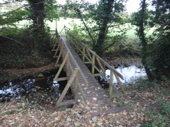
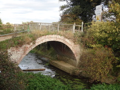
The path passes a house on the right and joins a track; head straight on along the track as it curves to the left. It passes the inposing Weybread House on the left; immediately after the house a track junction is reached at TM242818; do not continue along the track and instead turn hard-left to follow the driveway that leads towards the house. When the driveway splits at two gateways pass through the right-hand gate that leads towards an old mill. Turn right in front of the mill to reach a small bridge over the mill race. This leads on to a long footbridge over the River Waveney.
On the other side of the footbridge continue along the path with a little ditch to the right; soon a footbridge leads over the ditch. On the other side of the bridge turn half-left to angle across a field towards the far corner of the field. Go through a wooden clapper gate at the end of the field and climb up to reach a road called Wells' Lane at TM242821. Turn right to follow the road eastwards for a quarter of a mile until it ends at a T-junction with the B1116 road. Turn right to follow the B1116 southeastwards towards Shotford Bridge over the Waveney; there is a pavement on the other side of the road.
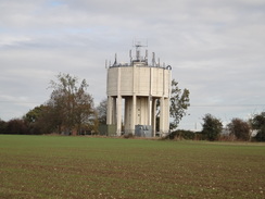
Just before the bridge is reached turn left along a footpath that climbs steeply uphill through trees, with a fence on the right. The path leaves the woodland and descends slightly to reach the A143. Carefully cross the main road and on the other side climb eleven steps to a stile. On the other side follow a footpath between unfenced fields, with a large water tower to the right. This path leads onto Spirkett's Lane at TM245826; turn left down the road for a short distance, then turn right along a footpath, with a hedge on the left. When the field on the right ends the path crosses a footbridge over a ditch and heads on between fences. Cross a road and head on along the path; it becomes a gravel track before ending at Mandham Lane in Harleston at TM245831.
Turn right and follow the lane as it curves to the left to head eastwards out of the town. After 0.3 miles it curves sharply to the right; here turn left to join a track that continues eastwards between hedges towards Briar Farm. The track passes through the farm and continues on between fields before ending at a couple of field gates that guard it from the A143. Cross a stile to the right of the gates to reach the main road at TM255831.
Carefully cross the main road, and on the other side head on eastwards along a track; it slowly becomes grassy with a ditch on the right. After a while turn right over the ditch and then left to follow a smaller ditch on the right. The path curves to the left and starts heading slightly downhill before ending at Low Road at TM266830. Turn right down this road for about eighty yards and then turn left across a stile into a field. A footpath heads diagonally across this field for a short distance to reach a plank footbridge across a ditch; this leads to a stile that climbs up onto a road called The Street to the west of Mendham. Turn left and follow this road as it heads eastwards, crossing a bridge over the River Waveney and reaching Mendham Church at TM269829.
The road passes the church on the right, then curves to the right and then the left, passing the Sir Alfred Munnings pub on the left. It continues eastwards through the village for a short distance before ending at a crossroads. Turn left at the crossroads and follow Denny's Hill road northwards; it passes houses on the left before leaving the village and curving to the right up a slight hill. Half a mile after the crossroads at TM277833 turn left across a stile to join a footpath.
The footpath heads across a field, keeping a hedge to the left. The field narrows before the path goes through a gap in a hedge; on the other side turn half-right towards a footbridge over a stream. Go through the gates guarding the bridge and continue on for about twenty yards across a field to another stile. Cross the stile and immediately turn left to follow a hedge on the left. The path curves to the right with an intermittent field boundary to the right; it follows the base of a slope to the right. Cross a stile beside a metal field gate and continue on with some woodland to the right. This leads to another stile beside a wooden field gate; cross this and continue on along a track past a house and then Downs Farm on the left at TM283841.
The track becomes surfaced as it starts to curve to the right; as it does so turn sharply to the left to pass a black wooden barn on the left. It descends down a slight slope to reach a stock fold that blocks the track. Pass this on the left to reach a stile on the right. Cross this and follow a fence on the right that runs along the top of a bank; it may be easier going to drop down to the base of the slope. At the end of the field cross another stile to enter some woodland. The footpath heads through the woodland with a hillside to the right and a stream down to the left. The Waveney approaches from the left; the path climbs slightly. Squeeze past a metal field gate and follow the path as it curves to the left to reach a road at TM287847.
Follow the road north for a short distance; as it curves to the right to head uphill, turn left down a minor road which heads northwards for a quarter of a mile before ending at a triangular junction with another road. Turn right at the junction to start following a road uphill; as the road curves to the right turn left past a field gate to join a path that heads through some woodland. It passes a lake down to the right before passing Holmersfield Church to the left. Pass the church and some barriers to reach the end of a surfaced road; follow this until it ends at a T-junction with another road in Holmersfield at TM285855.
Turn right to start following this road northeastwards out of the village; as it curves to the left to join the B1062 head straight on along a sliproad which in turn ends at the B1062. Carefully follow the main road northeastwards; care needs to be taken as there is no pavement. After a couple of hundred yards turn right along a bridleway that heads past some woodland on the right. This soon meets a track; turn left down this track and follow it past a flooded gravel pit to the left.
Continue along this track as it curves to the left and slowly climbs; after nearly half a mile it reaches a crossing with another track at TM298859. Turn right to follow another track that starts to climb away from the quarry. Immediately after passing the top of the first field on the left, the track curves slightly to the left and the right to approach Home Farm. At the farm turn right to pass between the farm buildings; the track soon curves to the left to head south-southeastwards for a third of a mile before ending at Park Road at TM301849 opposite Chestnut Tree Farm.
Turn left to follow the road as it winds northeastwards; after a couple of hundred yards turn right along a track with a hedge on the left. The track passes Shingle House some way away to the left before curving to the right; as it does so turn left along a path that runs northeastwards between fields. After a while a hedge and ditch starts on the right; shortly after this turn left and then right to continue with another ditch on the left. The path and ditch meet Coombe's Wood; turn right and after about ten yards to the left, still following the ditch on the left. It curves to the right and the left once more before passing a house on the left and ending at another track at TM313851.
Turn left and follow this track northwards for a sixth of a mile until it ends at a bend in a road. Join the road for a few yards and then turn right along another track that head eastwards; it passes Packway Wood on the left and after 0.6 miles it ends at another minor road. Cross this road and continue on along a gravel track that leads towards Sternacre Farm. When the track turns to the right to enter the farm, continue straight on along a path with a hedge on the right. This path becomes a green track that curves to the left, passing an old airfield site (now fields) to the left. The track curves to the left and soon afterwards a hedge starts on the right.
When some woodland is reached turn left, initially passing the woodland on the right. The track continues between fields; the hedge ends and it continues alongside a ditch. Turn right for a couple of yards and then left to join another track with a hedge now on the left. This track becomes roughly surfaced (actually an old airfield perimeter track) as it continues on. As the track curves to the right towards a farm turn left down a footpath that heads through a band of woodland and across a few yards of grass to reach another part of the old perimeter track.
Turn right and follow the track as it curves to the left; shortly afterwards it passes on the left what could be the stub end of an old main runway. Pass this and then turn right along a path; soon a hedge starts on the left. A short distance later a hedge starts; turn left through a gap in the hedge to enter a field. Follow a ditch and hedge on the left; the path curves to the right, climbing up a slight hill. Follow the hedge as it curves to the left; soon afterwards it curves to the right, and when the hedge on the left ends turn left across a stile and head downhill with a hedge on the left. At the bottom of the hill go through a pedestrian gate to reach the B1062 at TM330882.
Carefully cross the B1062 and heads straight on along a bridleway that runs between hedges. At the end it reaches a metal chain-stile beside a wooden field gate. Cross the stile and turn slightly to the right to head across a field northwards to reach a track beside a bridge over a stream. Cross the stream using the bridge and continue along the track. As it curves to the left, turn half-left to head northwestwards across a field, keeping the Waveney to the right; aim for a church spire ahead. It eventually reaches a metal footbridge over a tributary of the river at TM327886.
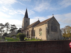
Cross this footbridge and then about ten yards of land to reach a wooden bridge over another tributary. On the other side turn half-right to follow a narrow path with a stream to the right. When the path reaches a track that crosses an arched bridge over the stream, turn left down the track for a couple of hundred yards until Earsham Church is reached on the left. Continue on as the track becomes a surfaced public road; as this curves to the left turn right along a track.
This track soon becomes a narrow footpath that curves to the left to head northwestwards. It crosses a minor residential road and continues along a surfaced path before it ends at The Street in Earsham at TM322890, with the Queen's Head pub to the left. Cross the road and head up Station Road northwestwards for a couple of hundred yards until it reaches a turning area near the A143. Pass to the left of the turning area to reach the main road.
Here the route leave the Angles Way for the day; turn around and make your way back to The Street. Turn left and follow this road northeastwards for a mile; it crosses a couple of bridges over streams before climbing uphill to enter the small town of Bungay. The road levels off and curves to the right, passing the Market Place roundabout on the left. Keep the Kings Head Hotel to the right and continue on for a few yards until the Butter Cross is reached on the left, where this walk ends.
 |
 |
|
Distances
| From | To | Distance (m) | Ascent (ft) | Descent (ft) |
|---|---|---|---|---|
| Diss | Brockdish | 7.9 | 295 | 259 |
| Brockdish | Harleston | 4.9 | 220 | 246 |
| Harleston | Holmersfield | 4.1 | 128 | 177 |
| Holmersfield | Earsham | 6.8 | 197 | 223 |
| Earsham | Bungay | 1.0 | 30 | 10 |
This makes a total distance of 24.7 miles, with 870 feet of ascent and 915 feet of descent.
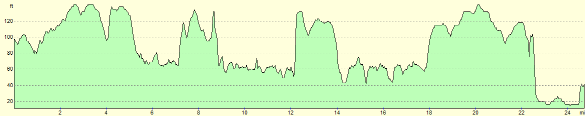
For more information on profiles, ascents and descents, see this page
Transport
To travel between Bungay and Diss, you can use Anglian Coach and Bus service 580, which travels between Beccles and Diss roughly every hour during the day. This service calls at Harleston on the way.
 |
 |
|
 |
 |
|
 |
 |
|
 |
 |
|
 |
 |
|
 |
 |
|
 |
 |
|
 |
 |
|
 |
 |
|
 |
 |
|
 |
 |
|
 |
 |
|
 |
 |
|
 |
 |
|
 |
 |
|
 |
 |
|
 |
 |
|
 |
Disclaimer
Please note that I take no responsibility for anything that may happen when following these directions. If you intend to follow this route, then please use the relevant maps and check the route out before you go out. As always when walking, use common sense and you should be fine.
If you find any information on any of these routes that is inaccurate, or you wish to add anything, then please email me.
All images on this site are © of the author. Any reproduction, retransmissions, or republication of all or part of any document found on this site is expressly prohibited, unless the author has explicitly granted its prior written consent to so reproduce, retransmit, or republish the material. All other rights reserved.
Although this site includes links providing convenient direct access to other Internet sites, I do not endorse, approve, certify or make warranties or representations as to the accuracy of the information on these sites.
And finally, enjoy your walking!
Nearby walks
| # | Title | Walk length (miles) |
|---|---|---|
| 135 | Darsham Station to Brampton Station | 12.3 |
| 167 | Brampton to Lowestoft | 12.3 |
| 719 | Stowmarket to Diss | 19.5 |
|
|

|