Walk #932: Hadrian's Wall Path: Newcastle to Wallsend and on to Cullercoats
 |
 |
|
General Data
| Date Walked | 27/09/2011 |
| County | Tyne and Wear |
| Start Location | Newcastle Central station |
| End Location | Cullercoats station |
| Start time | 09.35 |
| End time | 17.25 |
| Distance | 17.2 miles |
| Description | This was an ambling walk, following the last few miles of the Hadrian's Wall Path to Wallsend, and then roads and paths to Tynemouth and up the coast to Cullercoats. Although it is far from being a classic walk, it was enjoyable with many things to see and do. |
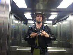
| Pack | Today I carried my 30-litre Karrimor rucksack, filled with water, my waterproofs, a book and other odds and ends. |
| Condition | This was an unusual walk for me; it was more of an amble than a real 'walk', and I made some diversions and even (shock, horror!) visited a museum. Consequently I felt fine, with no problems to report. |
| Weather | This was another good day for a walk, with no troublesome weather. It was surprisingly warm for the time of year, and there was little breeze to cool me down. |
| OS map | Landranger number 88 (Newcastle Upon Tyne, Durham & Sunderland) |
 |
 |
|
Map of the walk
Maps courtesy of Google Maps. Route for indicative purposes only, and may have been plotted after the walk. Please let me have comments on what you think of this new format. For a detailed table of timings for this walk, please see the table file.
 |
 |
|
Notes
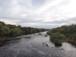
Today had an end-of-term feeling about it. I only had five or six miles to walk to reach the end of Hadrian's Wall Path, and then another few miles to connect that up with my coastal walk at the Tyne Foot Tunnels. After the hard walking of the last fortnight I felt like a little rest, so after a (for me) hearty breakfast I drove down to Wylam Station.
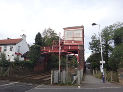
It seems fitting that there is a station at Wylam, as it stands a more than fair chance of being the place where modern railways originated. The Wylam Colliery Waggonway opened in the eighteenth century to carry coal, and George Stephenson was born nearby. He would have seen horses pulling wagons past his door, which must have had some effect on his later career. Curiously the track gauge was five feet, the Roman four foot eight and a half inches gaining in popularity later. I was musing all of this as I got my kit together in the car park, dawdling enough to miss a train into Newcastle. This was no hardship and I spent the half-hour until the next train exploring the area, which included a bridge over the magnificent Tyne and a signalbox that is poised above the tracks on a gantry.
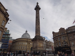
Once in Newcastle I decided to take a little stroll around the centre before heading down to join the trail where I had left it the day before. A magnificent column dedicated to the great political reformer Earl Grey stands proudly in a square. It was bedecked with a large number of people watching an impromptu game of football between two tiny goals. Members of the public were playing and two men were filming - God knows why.
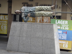
Newcastle did not massively impress me. Some pleasant-looking buildings inhabit the centre, but aside from some signature buildings the shops were distinctly down-at-heel - perhaps a result of the large shopping centres. The old Woolworths Store must have shut a couple of years before but it was still an empty shell despite being in what must have been a prime location. Things improved when I headed down towards the riverfront beside the Queen Elizabeth II bridge.
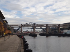
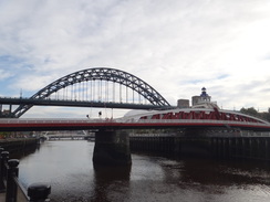
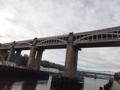
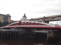
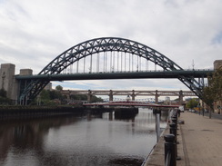
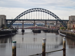
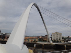
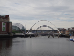
It was easy to see why Newcastle is famous for its waterfront: the number and variety of bridges within a short distance is, for an engineering geek like me, amazing. The amazing green arch of the Tyne Bridge (an early model of the Sydney Harbour Bridge) dominated a low-level swing bridge and three separate railway bridges. The outdated requirement to allow high-masted ships down the Tyne has led to these amazing structures.
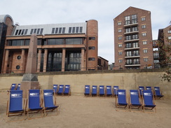
Consequently the waterfront seems to be the focus of the city, and many pleasant buildings lined it. Three cars and two vans belonging to a BBC film crew were parked imperiously at the roadside; the vans had satellite uplink dishes pointing towards the sky. Part of the promenade nearby had been filled with sand, and deckchairs had been set out around a volleyball net. It all seemed rather summery for a later September day, but was rather fitting for the day's warm sunshine.
On the Gateshead side of the river was The Sage, Gateshead, whose stainless-steel roof glinted in the sunshine. I have met several people who started the trail from Heddon-on-the-Wall or Corrbridge rather than Wallsend due to the perceived boring nature of the walk through Newcastle - this stretch utterly disproved this stereotype.
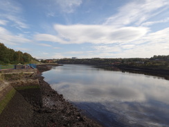
The tide was out, meaning that the waterfront was dominated by large expanses of mud. Pieces of wood stuck out of the mud and I spent a few moments considering the purpose of each one: perhaps they were the skeletal remnants of wharfs, dolphins or mooring posts. Weathering had sculpted some into wondrously weird steamlined shapes.
I decided to divert off the trail to walk over the Millennium Bridge, a sculptural bridge called by some the 'blinking eye'. It lifts up in an arc to allow ships underneath, and a board listed the opening times. I could not help but compare it to London's Millennium Bridge, and I cannot help but think that the north's version is far superior, both in looks, form and function. Two walkers came past as I rejoined the trail, two Dutchmen who were just starting off on their walk.
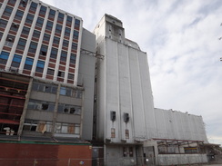
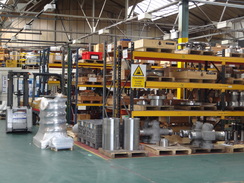
A large riverside building was being demolished. It was some sort of factory whose sundered remains stretched at least five stories into the sky, twisted sections of reinforcing bar sticking out like jagged wounds. This sign of industrial decline was offset when open doors allowed me to sneak a glimpse into another factory where shining blocks of metal sat ready to be machined into valves and other devices.
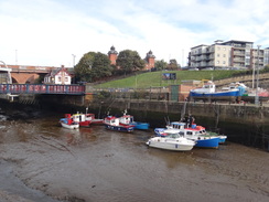
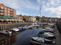
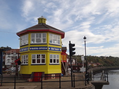
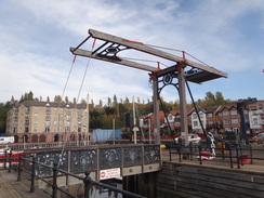
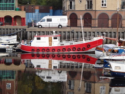
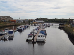
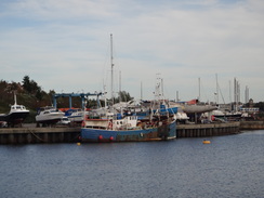
St Peter's Marina was a real gem; no sooner had I left the industrial area than I was by glistening water with boats and yachts moored around it. The scene was somewhat reminiscent of London's St Katherine's Dock, but smaller and less crowded. A striking octagonal building controlled the marina, and I crossed a lifting bascule bridge over the marina's entrance to pass this.
The next mile took me along the riverside, with some good views over the river. A sheen of oil on the water was explained by signs warning about pollution from an old tar works that used to sit by the shore. This was confirmed by a heavy diesel smell that hung in the air, yet the fisherman a few hundred yards upstream seemed oblivious to the pollution, leaving me to wonder if any fish they caught would be edible.
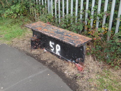
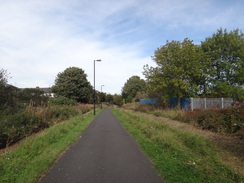
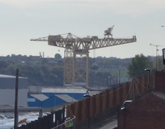
The path left the riverside path in St Anthony's and started to climb. Calm places on the river below marked the patches of oil, proving the old adage of 'oil on troubled waters'. At the top of this path it joined an old railway path. I caught a glimpse of a yellow hammerhead crane, which was sadly too far away to get a decent photo. I love these massive structures that seem strangely elegant despite their bulk, and it is a shame that so few now remain. Factories filled the slope between the path and the river, seemingly still in work and protected by high palisade fencing. A bench had been cut out of a massive old riveted girder, an unexpected and strangely fitting pathside ornament.
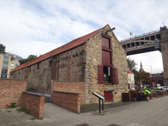
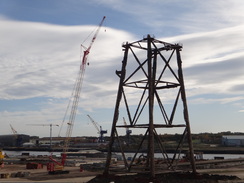
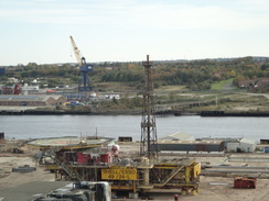
A couple of bridges had been removed meaning that roads had to be crossed on the level, but the walk was easy and unproblematic. Soon a large white building with red tile roof became visible to the left, my first sight of the museum that marks the end of the trail. The old Swan Hunter's yard lay on the other side of the path, its site marked by the massive legs of an oil platform that was being dismantled; the topside of the structure sat on the ground nearby.
I had now completed Hadrian's Wall Path, my third national trail in just over two weeks' of walking. However, I wanted to continue on downriver to see the actual sea, making the trail into a true coast-to-coast stroll. There was no hurry, so on an impulse to go in and have a look around the Segedunum museum, and I was glad I did. The museum is sited on the fort that marked the end of the Wall complex, although the remains of the old Swan Hunter shipyard now splits the river and the museum.
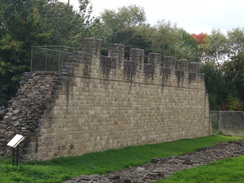
Although much of the museum is focussed towards children, it was fascinating to see a reconstructed Roman bathhouse and, joy of joys, a replica stretch of Roman Wall next to the uncovered foundations of the real Hadrian's Wall. Being a cynic by nature I wondered how accurate the reconstruction was, but it certainly gave an impression of the imposing nature of the wall.
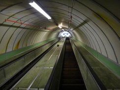
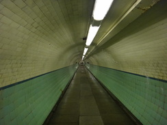
I left the museum in an enlightened mood, but sadly this did not last as I tried to make my way eastwards towards the Tyne Foot Tunnels, which I had used to cross the river on my coastal walk. Only by reaching these could I say that I had truly walked from coast to coast. There was one other reason to visit the tunnels, however: I have long held a feeling that I did not really 'walk' the coast because the down escalator into the tunnel had been moving when I entered the tunnel. This may sound stupid and perverse and you may well be right; however it has been something that has bothered me for some time.
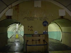
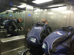
It was a relief to find that the down escalator was stationary, meaning that I could walk down it and therefore complete my loop of the coast, nine years after I began it. Perversely the up escalator on the other side was working in a groaning and creaking manner and I went up to momentarily visit Jarrow. At the northern end of the tunnel I shared a lift with a cyclist, the mirrors on the walls giving me a perfect image of infinite cyclists.
The area around the tunnels is undergoing drastic change; road works as part of the New Tyne Crossing had altered the road layout, and I could not find the cycle path marked on my now-old 1:50,000 OS map. The new tunnel is already open, and the old tunnel is currently closed for refurbishment. The stretch under the river was built as a submerged tube tunnel: the tunnel sections are cast in a dry dock basin, the riverbed dredged, and the tubes floated out before being sunk into position. However both cut-and-cover and boring machines were used to construct the approach tunnels, meaning that all three major tunnel-construction techniques were used in one tunnel!
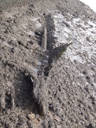
I ended up strolling across an area of wasteground that appeared to be grassed-over ballast. A short distance away the gravel appeared fresh and then, out of nowhere, there was a modern-looking platform with three solitary crossing timbers lying on the ballast. Crossing timbers are worth a fair amount of money (ordinary railway sleepers also can cost a fair bob) and so it seems particularly strange that they were here. I can only assume that the platform is something to do with the North Tyneside Steam Railway, whose southern terminal lies nearby at Percy Main.
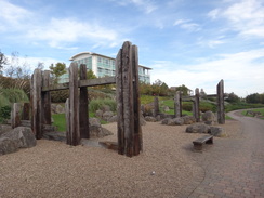
A path regurgitated me onto a road, which I followed for a short distance before taking a cycle path that entered a relatively new retail park. It did not stick with the road for long and soon diverted off into one of the more delightful public spaces I have passed through for some time. It was a wonderfully varied area, including reconstructed tall wooden groynes with inscriptions on them. The whole area lifted my spirits and seemed to have been very well designed. A couple of ferries or cruise ships were moored in the distance, their massive bulk dwarfing the yachts in a marina. One of these was the 28,000-tonne Boudicca cruise liner.
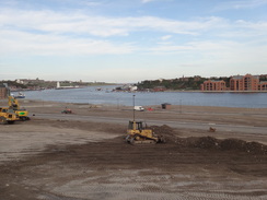
Road works diverted the obvious route nearest to the river, with large machines going to and fro across a flat area of land beside the river. This was apparently spoil from the new Tyne tunnels which had been used to fill some old dry docks; presumably the whole area will soon be redeveloped. A little further on I descended to reach an attractive-looking pub that once must have had most of its trade from the coal mines and ship yards in the area. Nearby a passenger ferry was plying its trade across the river to Jarrow; I was tempted to take a trip across but in the end decided against it.
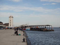
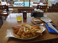
Instead I followed the road as it emerged onto a fish dock. People were fishing off the quays, and a fishing boat headed upstream as I strolled past. Soon I came across what looked like a good fish and chip shop and I decided to nip in as I had to eat something before going back to the B&B. The interior was smart and made me feel rather out of place in my rather dishevelled walking clothes, but the food was prompt and exceptionally good - it was the best fish and chips I have had in some time.
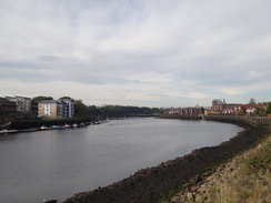
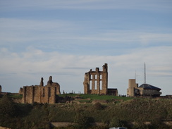
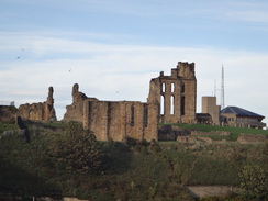
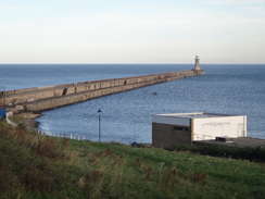
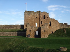
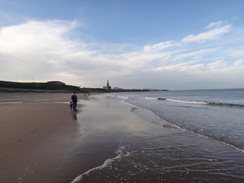
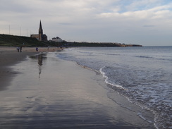
The day had turned into somewhat of an amble, and I strolled along towards a car park as a large ship made its way downstream. A smaller vessel joined it as it headed between the breakwaters; presumably a pilot vessel picking up the pilot. What followed was a pleasant stroll along a promenade towards the mouth of the river with good views across to South Shields on the other side. I walked slowly as I was in wind-down mode; when the promenade ended I climbed a slope to a grassy area that granted my first views of the day of Tynemouth Castle and the adjacent priory, both ruined. I must have looked quite a sight to the people around me, as I was grinning from ear to ear at the sheer joy of being back by the sea.
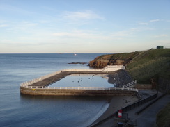
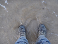
On an impulse I descended down to a promenade beside a little beach immediately below the castle. The promenade was short and when it ended I was forced to climb back up onto the cliffs once more. Soon, however, I was descending once more past an unused seawater pool to another beach. This was bustling with people who were enjoying this unseasonably warm early autumn weather. One of my boots had split a couple of days ago but I walked through the surf regardless; my trip was now over, with all objectives achieved, and a little bit of water would not kill me.
I felt as high as a kite, really happy, and could easily have continued on for another few miles along the coast towards St Mary's Lighthouse. Sadly the sun was slowly descending below the houses on the cliffs to my left, and so it seemed like a good idea to finish the day. A scuba diver and two girls in wetsuits were striding around in water that must have been fairly chilly. The nearest station at Cullercoats was easy to find, and soon I was heading back towards Newcastle Central Station.
It has been a superb trip, with three national trails completed in a little over two weeks. Every objective has been achieved, and even the comparatively miserable stroll along the Speyside Way had left fond memories. The trip has proved one thing: I am far fitter than I expected, and that can only be a good thing.
 |
 |
|
Directions
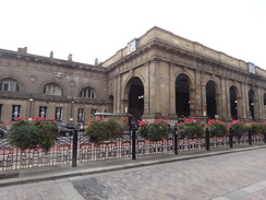
This walk starts off at the main entrance into Newcastle Central railway station at NZ245638. Although it follows the eastern part of Hadrian's Wall Path for much of the way, initially it takes a short trip into the centre of the city. Leave the station and carefully cross the A186 to head down Grainger Street. At the end of this road, cross the A186 Westgate Road and continue along Grainger Street, which soon becomes pedestrianised. Head along the pedestrianised road until the Earl Grey Monument is reached.
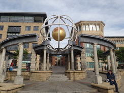
Here turn left to head westwards along Blackett Street; opposite a war memorial on the right, turn left through a shopping centre that leads out onto Clayton Street. Follow this south-southwestwards through the city; it crosses the A186 and becomes the A695. When it reaches the Life Centre head through the plaza at the centre of the complex, bearing slightly to the right to reach the A695 once more. Turn left to follow this south for a short distance and then turn left along the B1600 Forth Street. This passes under a large railway bridge and then curves to the right to head steeply downhill towards the Tyne. As the road curves to the left at the bottom of the hill, turn right along Skinnerburn Road for a short distance before turning to the left through a small car park to reach the path that runs along the northern bank of the Tyne.
Turn left and follow the path as it heads in a rough northeasterly direction through the city's riverside. It passes a series of spectacular bridges, including a swing bridge and the world-famous Tyne Bridge. After a little over a mile an inlet is reached at NZ264640; turn left to head north with the inlet on the right for about fifty yards until Quayside Road is reached. Turn right along this to cross the inlet on a bridge, and on the other side follow the road as it heads southeastwards. Pass St Lawrence Road on the left and then follow the road as it curves to the left, heading slightly uphill and taking a more easterly course. The road ends at a roundabout at NZ271636.
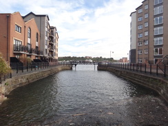
At the roundabout turn right down Glasshouse Street, and then take the first road to the left, Bottlehouse Street. This heads eastwards until it ends at a T-junction with Dobson Crescent. Turn right down this road, passing St Peter's Marina on the left. When the road ends continue on for a few yards to reach the riverside path. Turn left and follow this past buildings on the left to reach the lift bridge over the entrance to the marina. Cross this, and on the other side pass the striking marina office, which is housed in a yellow octagonal building. Keep this on the right until a road is reached; turn right down this road for a short distance to reach the riverside path once more.
Turn left and follow the riverside path as it heads in a rough easterly direction for 1.3 miles; it passes St Anthony's Point and the Walker Riverside Park as the path parallels the shoreline. At NZ292631 the path jinks to the right; as it does so, continue straight on along a sloping cycle path that immediately curves to the left to reach a junction with another path. Turn left up this path; it soon curves sharply to the right in a hairpin and continues to climb northeastwards. It passes a couple of vehicle barriers before joining the course of an old railway line at NZ293634.
Follow the cycle path as it slowly curves to the left to take a rough northerly course; after a third of a mile it descends to cross Malaya Drive (the old railway bridge to the right is missing). Cross the road and continue northwards for along the cycle path. It crosses a couple of streets on bridges and then Mary's Place on the level before reaching Welbeck Road. Cross this on the level (again, the bridge to the right is missing) and continue on along the cycle path to reach Neptune Road, where again the bridge is missing. Carefully cross the road and rejoin the cycle path on the other side. This heads northeastwards, passing under Benton Way.
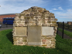
Soon a white building with orange clay-tile roof becomes visible to the left; this is the reconstructed Roman bath house on the site of the Segedunum Roman Museum. Continue on for a short distance until a small gate is reached in the railings on the left; the eastern trailhead of Hadrian's Wall Path is situated at a stone engraved with the builders of the wall at NZ301660. If the gate is not unlocked then you will need to go through the museum to gain access.
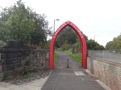
If you do not want to visit the museum, then continue on over a bridge over Station Road, with the museum entrance in a building to the left and an entrance to the old Swan Hunter shipyard on the right. The cycle path continues on, curving to the left and then the right to reach Carville Road. Cross this and follow the cycle path as it passes a petrol station on the left and twists and turns as it heads in a rough easterly direction. After a third of a mile it passes through a red metal arch to reach the A187 Hadrian Road.
Turn right to start following the A187 eastwards; there is a good walkway and cycle path on the southern side of the road. Follow this eastwards for nearly a mile; shortly after it crosses a bridge over Willington Gut continue on along the A187 for another half-mile until a roundabout is reached at NZ326663. Take the second exit to continue along the A187. I took the first road off to the right, Coach Open, to reach the pedestrian tunnel that runs under the Tyne. If you do not want to visit Jarrow, then simply carry along the A187 as it heads eastwards.
The road soon curves to the left above the entrances to the Tyne Road tunnels to reach a large roundabout. Take the second exit, Howdon Road, and follow it up past rows of houses. When it ends take a path that continues on for a short distance to reach the A187 once again. Turn right and follow the dual carriageway eastwards; cross straight over a roundabout and continue to another. Here take the second exit to the right, Coble Dene, which leads into the Royal Quays shopping complex.
Head down Coble Dene, following a National Cycle Network path. At a traffic-light controlled pedestrian crossing, turn left to cross the road and on the other side turn right to follow the cycle path towards another roundabout. At the roundabout turn left and follow the cycle path as it trickles off to the left, passing through the middle of a spectacularly landscaped area. This twists and turns, slowly curving to the right to reach Chirton Dene Way. Cross this road and continue along the cycle path as it descends to reach the western side of a marina at NZ349668.
Turn left to follow the cycle path as it heads north with the marina on the right. It jinks to the right and then the left to pass under a bridge that heads over an inlet; soon turn right over a bridge across the inlet. On the other side turn right to head under the overbridge once more; continue along the path as it joins the end of Ballast Hill Road, which soon climbs. As it climbs it curves to the left to head inland; shortly after it curves to the left once more, turn right down Prince Consort Way. This soon becomes Dock Road; take the first road to the right, West Lawson Street, and follow this as it heads northeastwards.
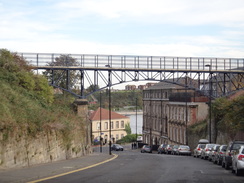
When this ends at a T-junction with Coach Lane cross this road and follow a pavement that soon joins Addison Street. Follow this northeastwards; when it ends a path continues on to end at Borough Road. Turn right to head down Borough Road, passing under an elegant bridge overhead. At the bottom of the hill the road curves to the right towards the landing of the Market Place pedestrian ferry that shuttles people across to Jarrow; at the bend turn left down Clive Street, passing The Porthole pub on the right.
Continue along Clive Street as it parallels the shoreline, with buildings blocking the views of the river. It becomes Liddell Street, Bell Street and then Union Quay as it passes a fish market on the right. After the market ends, turn right down a road that heads eastwards for a short distance to the old fort. At the fort turn left to pass between buildings to reach a car park at NZ363685.
At the car park turn right and follow the cycle path as it follows an esplanade along the northern bank of the Tyne towards Tynemouth. After a third of a mile the path ends at a headland; just before it does so turn left up a slope. This curves to the left to head north, becoming a road as it passes a car park on the right. Continue along the road as it passes a beach on the right and climbs up past Tynemouth Castle on the right, with the priory beyond.
Pass the entrance to the castle on the right and head towards the Gibraltar Rock pub. Head past the pub on the left, with the cliffs on the right, then turn right down a steep flight of steps that leads down to King Edward's Bay. At the bottom turn left along a short stretch of esplanade that follows the slowly curves to head northwards. Sadly it soon ends, and before it does so take a ramp that leads up to the left, emerging onto Sharpness Point.
Cross the grass on the point, skirting the road on the left. Take some steps that lead off to the right, heading down to the start of an esplanade with some sea baths on the right. Once at the esplanade turn left and follow it for a short distance before descending down onto the beach. Head north across the beach for a little over half a mile. Shortly before you draw level with the church spire on the left, turn left off the beach onto a ramp. This becomes a road called Longsands that heads uphill before joining Beverley Terrace.
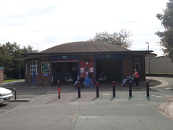
Turn right and follow Beverley Terrace northwards. As the road starts curving to the right, angle off to the left along another road. Take the first major road off to the left, Station Road, and follow this until it ends at Cullercoats station at NZ361713, where this walk ends.
 |
 |
|
Distances
| From | To | Distance (m) | Ascent (ft) | Descent (ft) |
|---|---|---|---|---|
| Newcastle Central station | Wallsend | 7.6 | 413 | 476 |
| Wallsend | Fish Quay | 6.7 | 505 | 551 |
| Fish Quay | Cullercoats station | 2.9 | 381 | 322 |
This makes a total distance of 17.2 miles, with 1299 feet of ascent and 1349 feet of descent.
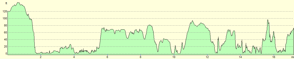
For more information on profiles, ascents and descents, see this page
Transport
The Tyne and Wear Metro operates services between Cullercoats and Newcastle Central stations.
Accommodation
I spent the night at the Ironsign Farm B&B, a pleasant B&B situated right on Hadrian's Wall Path about two miles west of Heddon-on-the-Wall.
 |
 |
|
 |
 |
|
 |
 |
|
 |
 |
|
 |
 |
|
 |
 |
|
 |
 |
|
 |
 |
|
 |
 |
|
 |
 |
|
 |
 |
|
 |
 |
|
 |
 |
|
 |
 |
|
 |
 |
|
 |
 |
|
 |
 |
|
 |
 |
|
 |
 |
|
 |
 |
|
 |
 |
|
 |
 |
|
 |
 |
|
 |
 |
|
 |
 |
|
 |
 |
|
 |
 |
|
 |
Disclaimer
Please note that I take no responsibility for anything that may happen when following these directions. If you intend to follow this route, then please use the relevant maps and check the route out before you go out. As always when walking, use common sense and you should be fine.
If you find any information on any of these routes that is inaccurate, or you wish to add anything, then please email me.
All images on this site are © of the author. Any reproduction, retransmissions, or republication of all or part of any document found on this site is expressly prohibited, unless the author has explicitly granted its prior written consent to so reproduce, retransmit, or republish the material. All other rights reserved.
Although this site includes links providing convenient direct access to other Internet sites, I do not endorse, approve, certify or make warranties or representations as to the accuracy of the information on these sites.
And finally, enjoy your walking!
Nearby walks
| # | Title | Walk length (miles) |
|---|---|---|
| 231 | East Sleekburn to Howdon | 18.0 |
| 232 | Howdon Station to Sunderland Station | 15.3 |
|
|

|