Walk #894: A circular walk between Denton and Westborough
 |
 |
|
General Data
| Date Walked | 13/04/2011 |
| County | Leicestershire, Lincolnshire |
| Start Location | Denton |
| End Location | Denton |
| Start time | 08.12 |
| End time | 16.03 |
| Distance | 22.7 miles |
| Description | THis was a pleasant but not particularly scenic stroll following the Viling Way northwards, before returning along roads. |
| Pack | Today I carried my 30-litre Karrimor rucksack, filled with water, my waterproofs, a couple of books and other odds and ends. |
| Condition | I have more blisters on my heels after this walk, an unuaul occurence that could be due to the damage I did to them on last week's walks, added to a great deal of road walking. |
| Weather | Today's weather was mostly overcast, with only short glimpses of the sun. THe wind was quite chilly, and there were occasional periods of light drizzle. |
| OS map | Landranger number 130 (Grantham, Sleaford & Bourne) |
 |
 |
|
Map of the walk
Maps courtesy of Google Maps. Route for indicative purposes only, and may have been plotted after the walk. Please let me have comments on what you think of this new format. For a detailed table of timings for this walk, please see the table file.
 |
 |
|
Notes
After my campaign to walk the Sandlings Way had (more or less) been completed, I wanted to start something else. Five years ago I walked the southernmost twenty or so miles of the Viking Way, and it felt like a good trail to tackle next. I had followed the trail as far as a point due west of Grantham, and I did not fancy redoing the stretches to the south. Unfortunately the public transport to the villages is not very good, so I had little choice but to plan a circular walk.
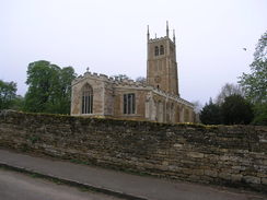
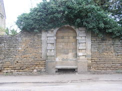
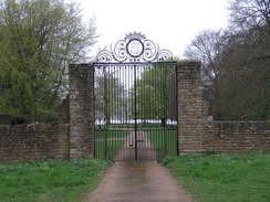
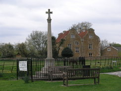
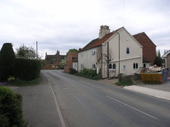
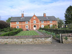
I find it hard to find a place to park in the little village of Denton. Eventually I decided to risk parking on the roadside between the village and pub, the pub car park being the only other possible alternative. It took me longer than normal to get my kit together as I had to change the batteries in both my GPS and MP3 player, but soon I was striding off down the road. Denton itself is a quiet, small village with some interesting buildings - the older ones seem to be constructed out of a pleasant type of stone (ironstone?), and there was a stone seat inset into a wall. At the top of the road, just before the A607, was an impressive gatehouse that once led to Denton Manor.
My first task was to reach the place where I had left the Viking Way on my last walk, and unfortunately there was little choice but to do some road walking to get there. Initially a quiet lane climbed uphill - only two cars passed despite it being before nine and the rush hour. The next road was also quiet as it took me southwestwards towards a copse called Three Queens, where I joined the Viking Way.
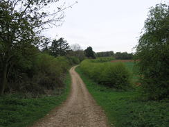
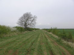
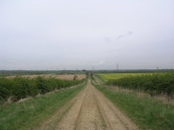
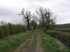
The Viking Way spends many miles following tracks in this part of the world, and I managed to make good progress despite the extensive rutted sections. The lack of recent rain meant that there was absolutely no mud, and this meant that I could keep up a (for me) fast pace. The tracks crossed the A607 once more and continued on northwards, with occasional good glimpses over the valley floor to the northeast. It became rougher underfoot as it started to descend down to the valley floor, but it was never too steep - indeed, it was going to be yet another day without too many ascents or descents.
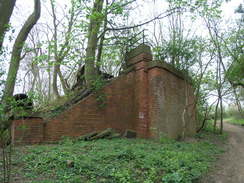
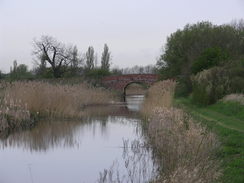
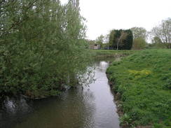
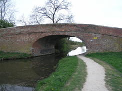
The track crossed another road and then crossed a bridge over an old railway line; this is the start of a cycle path that I saw later. It was still easy going as it met another road at Brewer's Grave, and there were some good views over the valley to the northeast; unfortunately these were only intermittent due to the trees that lined the track. After passing the abutments of an old railway bridge - the end of the cycle path passed earlier - the Grantham Canal was reached.
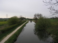
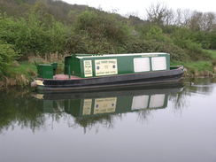
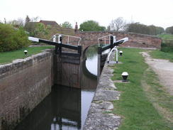
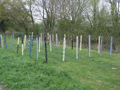
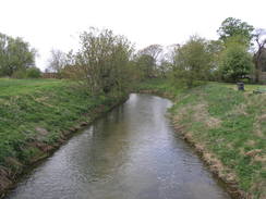
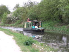
I had walked this stretch of the canal before as part of a walk west from Grantham. The 33-mile canal opened in 1797 and closed in 1936, although the Grantham Canal Society are working hard to reopen it. This stretch was in water, although the locks I passed were in various states of repair. The first three locks at Woolsthorpe were substantially complete but not in use, whilst another was simply a weir with no gates. The canal society had a canal boat moored on the navigable section, its windows boarded up. A little further on there were a series of stange posts stuck vetically in the ground, each painted with different garish colours. I am not quite sure what the purpose of these were, but they were certainly colourful.
There is a pub at Woolsthorpe Wharf that was shut at this early hour. An old railway line ran to the right-hand side of the canal, and this now carries a cycle path that seemed to be doing a brisk trade in dog walkers. All too soon the trail left the canal and continued north on a rutted track. This passed through an area of woodland, passing a farm before becoming a surfaced road that ended at the A52.
After this the trail crossed the Nottingham to Grantham railway line; there was a traffic light system showing that it was clear to cross. This is definitely better than the old system of having to look carefully in both directions although, naturally enough, I did look. Another track stretched northwards. On the way I passed a little encampment formed of a caravan and tent. The washing line stretched to the hedge showed that they had been there for some time, and I had a quick chat with them before pressing on. It was good to be able to chat to someone on what was turning out to be a remarkably solitary walk.
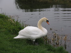
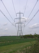
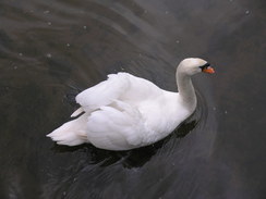
My feet were starting to get tired as I passed under some power lines and joined a surfaced road that took me up to the A1(T). A bridge took me over the main road and minor roads into the outskirts of the village of Long Bennington. This led to a small footbridge over the River Witham; a couple of swans were swimming underneath it, and ducklings were splashing around in the water on the other bank of the river. All in all it was a very pleasant spot, and for a moment I considered stopping here to have a bite to eat. However it was starting to spit with rain, so I plodded on across the path that led cross the floodplain towards Westborough.
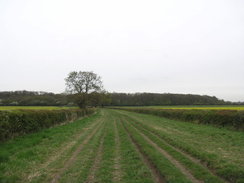
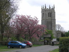
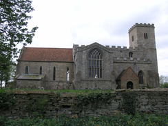
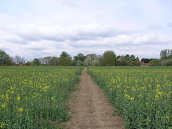
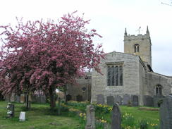
This appeared to be a pleasant looking village, and the church was nicely situated amongst trees. Another footbridge took me across the Witham for a final time, and then across fields, including one filled with early-flowering oil-seed rape. This led to a lane, where I left the Viking Way for the return to Denton. A pub marked on the OS map seems to have closed, and so I walked on, hoping that the next one in Allington would be open.
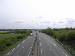
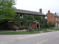
First I had to re-cross the A1(T). Whereas I had crossed it before using a bridge, now I had to cross the busy dual carriageway on the level. Fortunately the road was designed for pedestrian crossing, and there was a refuge in the middle of the road that allowed me to break my dash against the traffic. On the other side a road led into Allington, where the pub, the Welby Arms, was open. I went in an ordered a pint of bitter shandy and a couple of packs of crisps; the food looked very tempting, but I did not want to ruin my appetite for my evening meal. The barmaid was very friendly and I did not really feel lime leaving, but eventually I pulled myself away and got back on the road. Just south of the village was a round stone structure; a covered well called Salt's Well, which once provided water for the village. Although water was trickling out of it, I was not brave enough to take a taste.
One disadvantage of the pub being busy was that I could not take my boots off, and my feet soon resumed aching as I headed south along the road. I passed under the railway line once more to enter Sedgebrook. My plan had been to follow roads all the way back to Denton, but on a whim I decided to extend the walk by taking a more rural walk. The A52 was busier and harder to cross than it had been in the morning, but the road heading south was far quieter.
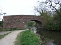
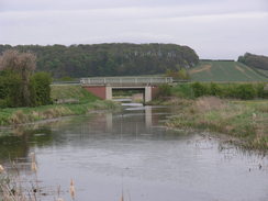
I left this road to continue along a track southwards back towards the canal. At Longmoor Bridge I rejoined the canal and headed eastwards. The Grantham Canal Society narrowboat I saw earlier was motoring along the canal with a full load of ladies on board, all of whom seemed to be enjoying themselves. The next bridge over the canal was a superb wooden arch structure, and this was followed by what looked like a newly-built road bridge.
From here I had little choice but to follow the road southwards back into Denton. My feet were really aching by now, and I was concentrating on little more than getting back to the car. It was a relief when it finally came into sight, accompanied by one of the few glimpses of the sun. It had been a varied day; the stroll along the tracks of the Viking way had been enjoyable, but the return walk along the roads had not been quite the opposite. Fortunately the next two days along the Viking Way will be linear walks, meaning I can spend longer on the trail.
 |
 |
|
Directions
This walk starts off at the church in Denton. Head east along Chuch Street, passing the Welby Arms on the left. When Church Street ends, continue straight on eastward along another road. Follow this as it swings to the right to head uphill; it becomes Main Street as it heads through the village. After a third of a mile it ends at the A607 road at SK869320.
Carefully cross the main road and continue south along a minor road as it climbs uphill before flattening out. After a mile the road ends at a T-junction; here turn right to follow another road southwestwards for another three-quarters of a mile; as it curves slightly to the left turn right at SK859297 onto a track called The Drift, joining the Viking Way in the process. The Drift continues northwestwards for another two-thirds of a mile, running between hedges before ending at the A607 next to the Lincolnshire / Leicestershire border.
Carefully cross the main road and continue on along The Drift on the other side, immediately passing an area of woodland on the right. It starts curving slightly as it progresses northwards, passing some more woodland on the left as it descends steeply along a rubbly track.
At the bottom the going becomes firmer underfoot, and become surfaced for the last few yards before it meet Denton Lane after another mile at SK848320. The track becomes Sewestern Lane as it continues in a rough northerly direction for another mile, reaching Belvoir Road at Brewer's Grave. Cross the road and continue on northwards along another track between hedges; after a third of a mile it starts to curve to the right as the hedge on the right ends. It descends downhill, curving to the left and passing the abutments of an old railway bridge to reach Longmoor Bridge over the Grantham Canal at SK850350.
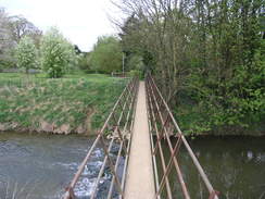
Cross the bridge to reach the northern side of the canal, and then turn sharp left; go through a metal squeeze gate and turn right to join the canal towpath. Follow the towpath westwards. At the Woolsthorpe Locks it curves to the right in a north-northwesterly direction. A mile after meeting the canal the trail angles off to the right just before Stenwith Bridge, crossing an old railway line that is now a cycle path. A hundred yards after leaving the canal cross a wooden ladder stile to reach a road at SK840361; the bridge over the canal is a few yards away to the left.
Cross the road and continue northwards along a wide, grassy and rutted track. After a short distance it curves sharply to the left and then the right; after another hundred yards it jinks to the right and then left until it is continuing northwards once more. It passes through the middle of some woodland before meeting a junction with another track near Mill Farm.
Turn half-right and follow the surfaced Sewstern Lane northwards, passing the farm on the left. After nearly half a mile it reaches the A52(T). Very carefully cross the road and continue north along the rutted lane on the other side. After a short distance it crosses this on a level crossing and heads northwards for nearly a mile to reach the end of Bottlesford Road at SK841396. Continue northwards for another 1.4 miles along the good track; it jinks a couple of times, but always maintains the northerly course. Near the top of a slight hill the track becomes firmer and less rutted. It passes through a couple of metal gates as it heads towards Thackson's Well Farm; here a surfaced road is joined. Follow this road north-northeastwards for a little under a mile until it ends at a T-junction with a sliproad leading off the A1(T).
Turn left along this road and follow it as it curves around to the right, crossing over the main road. As it descends turn right down a short road that curves to the right to meet another road. Turn right down this road. A short distance on there is a roundabout; take the first road to the left, Church Lane, and follow it northwards for a quarter of a mile. It curves to the right to approach Long Bennington church, and then sharply to the left to head northwestwards through Long Bennington.
A fifth of a mile after Long Bennington church turn right down a track that heads northeastwards, soon reaching a footbridge over the River Witham. Cross the bridge and go through the gate on the other side. Continue eastwards along an obvious path across a couple of fields, keeping the river bank about fifty yards away to the right. Go through a small wooden gate and then immediately over a footbridge over a stream, then turn half-left to head diagonally across the next field. When a hedge is reached on the left, turn half-right to follow the hedge eastwards, keeping the hedge on the left. When the hedge on the left curves left, continue straight on across the field to reach a stile in the next hedge.
Do not cross this stile, but turn left along a path that runs along a green lane that runs northwards between hedges. This soon curves to the right to head east-southeastwards for 150 yards, becoming the surfaced Baker's Lane that meets Witham Way in the village of Westborough. Turn right to head south along Witham Way for 100 yards; as it approaches the church it curves to the left to head east-southeastwards once again. The lane soon ends; continue straight on along a grassy footpath that heads southeastwards for a few yards to reach a footbridge over the Witham.
Cross the footbridge and on the other side turn half-left, to join a footpath that cuts across fields southeastwards. It goes through broad gaps in two hedges; a short distance into the third field it meets another footpath. Turn left and follow this footpath eastwards for a third of a mile across the field; a hedge appears on both sides before the path ends at Fallow Lane at SK860439. Turn right and follow Fallow Lane south for a fifth of a mile until just before North End Farm is reached.
When the Viking Way heads off to the left along a track at SK860436 continue south along the road for another half a mile into the village of Foston, passing the church before ending at a T-junction. Turn left and follow another road as it winds south for a third of a mile to reach the A1(T) dual carriageway. Carefully cross the road; there is a refuge in the central reservation to make this easier. On the other side continue south for 1.3 miles into the village of Allington.
The Welby Arms is passed on the left, and then the road curves to the left, becoming Sedgebrook Road. Continue south for 1.5 miles as it passes under a railway bridge and enters the village of Sedgebrook. It swings to the left in the centre of the village and then the right, to head on southwestwards for a sixth of a mile until it ends at a T-junction with the A52. Carefully cross the main road, and on the other side continue south-southwestwards along Woolsthorpe Lane.
After 09 miles the road curves to the right; as it does so continue straight on along a green lane called Longmoor Lane. After 0.8 miles this reaches the Grantham Canal at Longmoor Bridge; do not cross the bridge and instead turn left to follow the northern bank of the canal eastwards for two-thirds of a mile until it reaches Casthorpe Bridge at SK861348. Do not go under the bridge, andinstead tke a track to the left that heads up to the road.
At the road turn right to cross the canal by the road bridge. Head south along the road for about 1,5 miles until a road junction is reached in Denton at SK868326; here turn right along Church Street westwards. When the road jinks to the right, continue straight on along Church Street to pass the pub on the right and reach Denton Church, where this walk ends.
 |
 |
|
Distances
| From | To | Distance (m) | Ascent (ft) | Descent (ft) |
|---|---|---|---|---|
| Denton | A52 | 8.6 | 400 | 482 |
| A52 | Long Bennington | 4.1 | 39 | 148 |
| Long Bennington | Sedgebrook | 5.6 | 161 | 82 |
| Sedgebrook | Denton | 4.4 | 194 | 82 |
This makes a total distance of 22.7 miles, with 794 feet of ascent and 794 feet of descent.
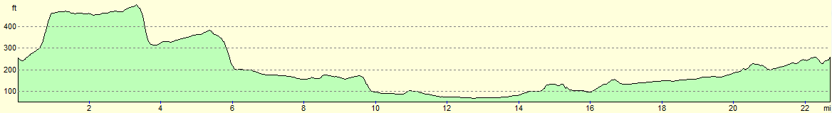
For more information on profiles, ascents and descents, see this page
 |
 |
|
 |
 |
|
 |
 |
|
 |
 |
|
 |
 |
|
 |
 |
|
 |
 |
|
 |
 |
|
 |
 |
|
 |
 |
|
 |
 |
|
 |
 |
|
 |
 |
|
Disclaimer
Please note that I take no responsibility for anything that may happen when following these directions. If you intend to follow this route, then please use the relevant maps and check the route out before you go out. As always when walking, use common sense and you should be fine.
If you find any information on any of these routes that is inaccurate, or you wish to add anything, then please email me.
All images on this site are © of the author. Any reproduction, retransmissions, or republication of all or part of any document found on this site is expressly prohibited, unless the author has explicitly granted its prior written consent to so reproduce, retransmit, or republish the material. All other rights reserved.
Although this site includes links providing convenient direct access to other Internet sites, I do not endorse, approve, certify or make warranties or representations as to the accuracy of the information on these sites.
And finally, enjoy your walking!
Nearby walks
| # | Title | Walk length (miles) |
|---|---|---|
| 593 | Sleaford to Bottesford | 23.3 |
| 594 | A circular walk between Bottesford and Bingham | 19.2 |
| 727 | A circular walk from Thistleton to Croxton Kerrial | 23.7 |
|
|

|