Walk #892: A circular walk between Thorpeness and Dunwich
 |
 |
|
General Data
| Date Walked | 07/04/2011 |
| County | Suffolk |
| Start Location | Thorpeness car park |
| End Location | Thorpeness car park |
| Start time | 07.49 |
| End time | 15.43 |
| Distance | 19.8 miles |
| Description | This was a superb and interesting walk, following the Sandlings Walk north to the vanishing town of Dunwich before returning along the coast. |
| Pack | Today I carried my 30-litre Karrimor rucksack, filled with water, my waterproofs, a couple of books and other odds and ends. |
| Condition | I have rather bad chaffing after this walk, a sysmptom of wearing the wrong underwear and the unseasonal heat. |
| Weather | The morning was bright and sunny, and whilst it clouded over this afternoon, there was no real reduction in the warmth. |
| OS map | Landranger number 156 (Saxmundham, Aldeburgh & Southwold) |
 |
 |
|
Map of the walk
Maps courtesy of Google Maps. Route for indicative purposes only, and may have been plotted after the walk. Please let me have comments on what you think of this new format. For a detailed table of timings for this walk, please see the table file.
 |
 |
|
Notes
I woke up bright and early in my tent, and was pleased to see that the condensation that had bedevilled my tent the previous week was not present - there was a slight breeze, and I had left the tent flap partly open as it was a relatively warm night. It was a relief to find that my feet, troubled after yesterday's walk, were feeling much better in fresh and correctly-fitting socks. I ate some of my homemade cake, got dressed and drove off.
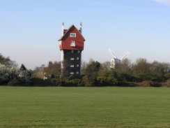
It took a while to reach Thorpeness, where I planned to start the day's walk. A day's parking cost £2.50, quite reasonable, and after paying I shouldered my rucksack and set off down the road. I had to walk a mile to reach the Sandlings Walk by Alexander Wood. On the way I passed close to the extraordinary House in the Clouds, a house built below a water tank. Along with its adjacent windmill, it dominates the surrounding area.
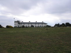
The trail skirted through the edge of the woodland before crossing part of Aldringham Common, another stretch of the spectacular Suffolk heathland. Sadly this ended all too soon as the track was enclosed by hedges. Near the Dower House it became a surfaced road, which passed Sizewell Hall, now a Christian Conference Centre but once the home of the Ogilvie family who built Thorpeness. The hall was guarded by a frankly ugly and ramshackle concrete wall, with none of the graciousness of the brick walls that usually guarded estates.
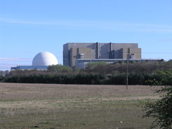
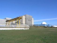
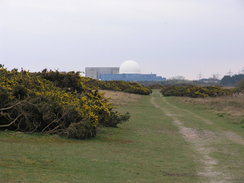
The road ended at a T-junction, where a wide road took me past the main entrance to the Sizewell power stations. The 650-MW Sizewell A power station was a Magnox reactor, and is located in a frankly hideous grey concrete building. It was decommissioned in 2006, and is in the slow process of being dismantled. The adjacent B power station is a very different creature, with a glorious white dome glinting above the blue buildings. Sizewell B was the last nuclear power station built in the UK, starting operation in 1995 and generates over 1GW of power. It is also the first Pressurised Water Reactor to be built in Britain, a sign that it was built for power generation rather than creating nuclear weapons materials.
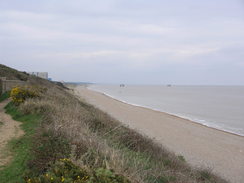
Although the beach in the area is shingle, there is a good grassy path that heads from the car parks at Sizewell Gap past the power stations, and it makes for a surprisingly enjoyable stroll, despite the presence of so much raw power nearby. Much of the bulk of the stations are hidden by vegetation-covered banks, and the sea is also out of sight behind similar banks. I really enjoyed the stroll, as I had on my coastal walk eight years before.
Just before reaching a line of concrete anti-tank blocks, the path turned to head inland, passing through a small band of heathland before crossing a stream on a bridge. A woman on a horse was waiting by the gate, her dogs playing in the water. As usual the horse was slightly unnerved by my approach; the walking poles strapped to my pack making me seem not quite human to them (also meaning that they are a very good judge of character!)
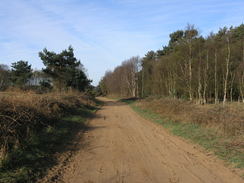
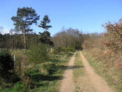
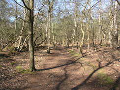
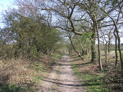
The Sandlings Walk was not marked on my OS maps, so I had had to trace them from the maps available online. Unfortunately these were not too detailed, so it was not clear where to go when the path reached the wooded flanks of Goose Hill. I had marked it as going over the hill, just south of the trig pillar, but the signs on the ground pointed down a track that skirted the edge of the trees. This walk was fairly easy and unremarkable, as was the next stretches past the wooded Kenton Hills and north into Eastbridge. Although they are called hills, Goose and Kenton hills are more like bumps in the landscape, rising to a massive nine and eleven metres respectively!
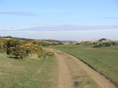
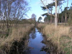
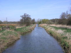
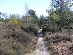
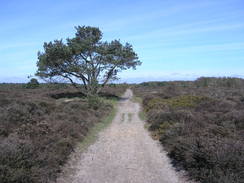
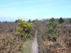
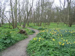
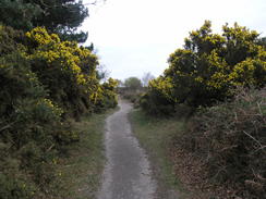
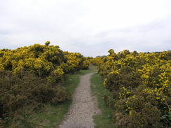
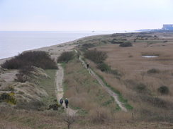
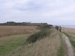
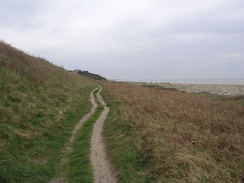
There was a nice pub in Eastbridge, after which the path crossed the Minsmere New Cut, one of the innumerable drainage channels for this low-lying land. After a few miles of fairly uninteresting walking, it was a relief when the trail started to enter better terrain, initially by following a track through woodland before it opened out, descending down to a stream and entering perhaps the best stretch of heath on the entire trail, across Dunwich Heath.
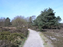
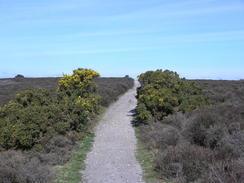
It was a spectacular walk in the sunshine, with the blue sky contrasting beautifully with the muted browns and greens of the heath. A few birdwatchers were scattered about with expensive-looking telescopes, but otherwise I was alone on the sandy trail. The trail neared the old whitewashed coastguard cottages on the heath, now a National Trust visitor's centre. At this point the path jerked away to cut directly across the heath, a spectacular stroll that, unfortunately, ended all too soon.
After crossing a road the path entered some woodland, emerging out onto another road on the outskirts of Dunwich. This quiet little village belies a literally larger past - it was once the capital of East Anglia, but erosion starting in the thirteenth century led to the vast majority of the town - including eight churches - being lost to the sea. The reduced size, if not status, of the town meant that until the Reform Act in 1832 it returned two MPs. I wonder if they represented Mermen...
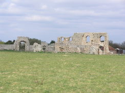
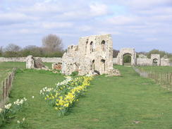
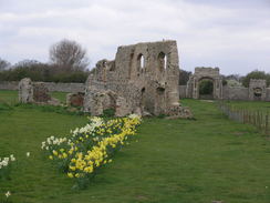
There are some ruins on land, in the form of Greyfriars, a Franciscan friary that itself was rebuilt when the more coastal Dominican Priory, Blackfriars, was abandoned. The stonework above ground are hardly the most impressive structures, but their survival against the sea and time is noteworthy. After another diversion through woodland, the path descended to meet the current shoreline and beach at Dunwich. I remembered the shingle beach (if not walking along it) with fondness from my coastal walk, along with the pleasant cafe behind it. It looked as though nothing had changed in the last eight years, and the sunshine made it a sublime spot.
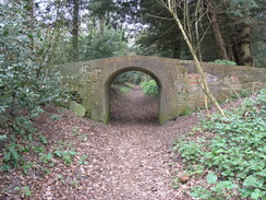
I was tempted to nip into the cafe for a bite to eat, but instead I decided to walk inland slightly to reach the Ship Inn. I went in and ordered a meal, and I chatted to the barman as I hungrily scoffed down the food. It was good, and the servings size was suitably large. As usual my appetite had been non-existent this morning, so I had not had much to eat. eventually I dragged myself away for the walk back down to Thorpeness. Instead of walking the same route back, I decided to follow the Suffolk Coast and Heaths Path. I walked a slightly different, seaward, route to the friary, replicating one that I took on the coast walk. This passed under a wonderful little bridge in the woodland, seemingly a throwback to historic Dunwich. During the lunchbreak I had taken off my fleece, but now the skies were clouded over, obscuring the sun and making the stiff breeze a little chillier.
Instead of walking across Dunwich Heath in the direction I had earlier, I walked down Minsmere road before diverting off to walk across the heathland between the road and the sea. Again it was a wonderful walk across classic heathland, spoilt only by the many obtrusive signs warning about the cliff edge some distance away. After squeezing past the old coastguard cottages, whose cafe was doing a roaring trade in the sunshine, the path descended down to a floodbank that separated the low levels of the Minsmere Nature Reserve from the sea. It was an easy walk, and fortunately there was no sign of the feet problems that had plagued me yesterday. Unfortunately they had been replaced with some bad chaffing that was causing not a little discomfort it was a shame that two glorious days of walking were being spoilt by such avoidable problems.
Many people were out and about, walking past and through the nature reserves. Soon the going became harder as shingle dominated the path with only occasional grass. It was a relief when I reached the stretch of path that passed the power stations once more. Again I enjoyed the way that the B power station seemed to blend in with its surroundings, although the A station was just as ugly from this angle. Out to sea are two towers, looking all the world like mini oil rigs, whose purpose must be something to do with the power stations - perhaps the cooling systems?
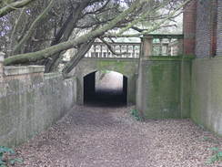
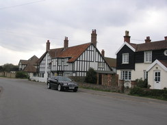
After passing Sizewell Gap the path climbed up onto the top of the cliffs, passing seaward of Sizewell Hall. At one point an impressive archway led under part of the grounds, allowing the people who stay there access to the beach. Again, however, the grounds were guarded by the same ugly concrete walls that I had seen earlier in the day. The path descended down onto the foreshore for a short distance, before climbing back up onto the cliffs near Thorpe Ness. It was an enjoyable stroll back into the wonderful village of Thorpeness, with its eclectic collection of buildings. It was a relief to reach the end of the walk, and I had no wish to extend the walk in any way.
Since it was still early, I called in at Aldeburgh and Orford on the way back in order to explore them a little. I have visited Orford before, and have always loved the not-quite-the-sea location, with the massive shingle Orford Spit separating the River Ore from the sea. After that I drove back to the campsite, still suffering from the chaffing. A meal in the local pub helped raise my spirits, but I can only hope that the chaffing will have healed well enough by the morning for me to do tomorrow's walk.
 |
 |
|
Directions
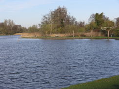
This walk starts off at the Thorpeness car park at TM472594. Leave the car park and turn right down a road that almost immediately ends at the B1353 road in the middle of the village. Turn left and follow the road as it skirts a lake called The Meare; a short distance later it curves sharply to the left to take a west-northwesterly course for two-thirds of a mile, passing the House in the Clouds' and a golf course on the left.
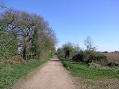
When a track crosses the road at TM462604 turn right to follow the road northwards for a couple of hundred yards until a footpath leads off to the right at TM461606, following a track. This track heads northeastwards, initially with some woodland on the right. It continues for a mile, slowly curving to take a more northeasterly course between hedges. Near Dower House at TM473616 it joins a surfaced road. Turn left and follow this road northwards for a little over half a mile until it ends at a T-junction with a road called Sizewell Gap. Turn right along this road and follow it east-northeastwards, passing the Vulcan Arms on the right. There is a pavement on the right-hand side of the road; it swaps over onto the left just after the Vulcan Arms.
After a quarter of a mile the road curves to the left to head northwards. When the houses end on the left, a path heads off slightly to the right, crossing through a car park and then passing another on the left. A good path continues northwards across grass, with the fence of Sizewell power station hidden to the left. At TM475645, one mile after leaving the road, turn left immediately before some anti-tank blocks to head westwards across heathland.
The path crosses a couple of small streams on footbridges and enters some woodland; it skirts westwards along a track past Goose Hill on the right, although it is hardly worth calling a hill. Continue along this track as it winds along with a stream on the left; it leaves the woodland and crosses an area of scrubland west-southwestwards. It re-enters an area of woodland, continuing in the same direction along the northern edge of the trees. It eventually passes a metal gate to reach a track at TM453639.
Turn right to follow this track northwards for 0.8 miles, passing Upper Abbey on the left. When the track forks take the left-hand fork and continue northwestwards for a short distance until the track ends at a road at TM453652. Turn right and follow this road as it heads in a rough northerly direction. After half a mile it enters the small hamlet of Eastbridge, passing the wonderfully-named Eels Foot Inn. At a road junction by the pub, continue on northwards along the road for another third of a mile, crossing Minsmere New Cut on a bridge.
At TM451667 turn right along a surfaced track that heads northwestwards through Hangmans New Wood; when the track curves to the right, continue straight on up Saunder's Hill along an unsurfaced track. It emerges from the woodland and continues between fields, with power lines on the left. It crosses another track and enters yet another area of woodland. A few hundred yards after entering the woodland turn right along a footpath that heads in a rough easterly direction through the trees, eventually leaving them to cross a stream and enter Dunwich Heath. Join a track that heads eastwards across the heath, slowly curving to take a more east-southeasterly course before reaching the old coastguard cottages (now a National Trust visitors centre).
Just before the cottages are reached, turn half-left along a clear track that heads north-northwestwards across the heathland. When the clear path curves to the left, continue straight on until a junction with a track is reached at TM469689. Turn right, and follow the track northeastwards for a quarter of a mile until Minsmere Road is reached. Cross the road, turn right and then immediately left to continue on northeastwards through some woodland. After a couple of hundred yards the path curves to the left, taking a more northerly course before ending after half a mile at Westerton Road.
Turn right and follow the road eastwards; as it curves to the left continue straight on along a track. Just before it meets a little arched footbridge, turn left to follow a path northwards through woodland. After a short distance it leaves the path as it approaches the ruins of an old friary; turn right towards the coast, and then left. The path descends down a sunken track with woodland on the right; after a short distance the path heads up to the right away from the track, and then left to head downhill through the trees. The path meets a lane in Dunwich at TM479705.
The route back from Dunwich is slightly different. Turn around and head along the footpath that heads through trees towards the top of the cliffs. When the top of the cliffs is reached, turn right to follow the cliff edge south through trees. After a short distance it jinks to the right to reach a track; turn left and follow this track uphill and to the south. It approaches the ruins of a friary and turns to the right, with some woodland on the left; after a short distance it turns to the left through the trees before ending at a track, with a small bridge on the left. Turn right to head westwards through the trees until it reaches a bend in a road at TM473700.
Continue on westwards along this road for a short distance, and then turn left down a track. This heads in a rough southerly direction before jinking to the left and the right, before regaining a southerly direction through Greyfriar's Wood. It crosses a track, and then curves to the right to head southwestwards before ending at Minsmere Road. Turn left and follow this road southwards; after half a mile turn right to follow a footpath that winds between the road on the right and the cliffs on the left. This eventually squeezes between the Coastguard Cottages and the cliff top. Immediately past the cottages turn right to walk a few yards to meet a track.
Turn left to follow the new track southwards. It descends and curves to the left; as it does so, leave it and turn half-left to follow a good footpath that runs along the top of a flood bank. Follow the path as it heads southwards behind the beach for two and a half miles; the path is easy to follow even after the bank ends. Shortly after passing the massive Sizewell nuclear power stations, the path curves to the right to end at the road at Sizewell Gap (TM475627).
Continue straight on, heading south along a path that initially runs behind the beach before climbing up onto the low cliffs. It passes a caravan site on the right and then Sizewell Hall. Shortly after the hall it descends back onto the foreshore for a short distance before climbing back up onto the cliffs. 1.8 miles after leaving Sizewell Gap it approaches the little village of Thorpeness. Gardens start on the right; the path becomes gravelled before reaching a lane at TM474598; turn right along this road for a few yards to reach a T-junction with North End Avenue.
Turn left and follow this road for a short distance until it ends at a T-junction with Old Homes Road; turn right along this, and take the first road off to the left, Church Road. Follow the road as it passes the church on the left, and then turns to the right to become the B1353. Continue south along this road and follow it as it curves sharply to the right. Take the first road to the left, Remembrance Road, and after a short distance turn left to enter the car park in Thorpeness, where this walk started.
 |
 |
|
Distances
| From | To | Distance (m) | Ascent (ft) | Descent (ft) |
|---|---|---|---|---|
| Thorpeness car park | Eastbridge | 7.1 | 167 | 157 |
| Eastbridge | Dunwich car park | 4.7 | 177 | 187 |
| Dunwich car park | Thorpeness car park | 8.0 | 272 | 272 |
This makes a total distance of 19.8 miles, with 616 feet of ascent and 616 feet of descent.
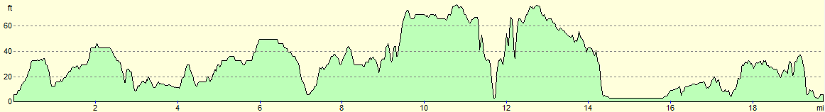
For more information on profiles, ascents and descents, see this page
Accommodation
I spent the night at Run Cottage, which is situated just outside the village of Hollesley. Itcost me just £10 for a ptich for the night, and the facilities were all clean and tidy.
 |
 |
|
 |
 |
|
 |
 |
|
 |
 |
|
 |
 |
|
 |
 |
|
 |
 |
|
 |
 |
|
 |
 |
|
 |
 |
|
 |
 |
|
 |
 |
|
 |
 |
|
 |
 |
|
 |
 |
|
Disclaimer
Please note that I take no responsibility for anything that may happen when following these directions. If you intend to follow this route, then please use the relevant maps and check the route out before you go out. As always when walking, use common sense and you should be fine.
If you find any information on any of these routes that is inaccurate, or you wish to add anything, then please email me.
All images on this site are © of the author. Any reproduction, retransmissions, or republication of all or part of any document found on this site is expressly prohibited, unless the author has explicitly granted its prior written consent to so reproduce, retransmit, or republish the material. All other rights reserved.
Although this site includes links providing convenient direct access to other Internet sites, I do not endorse, approve, certify or make warranties or representations as to the accuracy of the information on these sites.
And finally, enjoy your walking!
Nearby walks
| # | Title | Walk length (miles) |
|---|---|---|
| 132 | Wickham Market Station to Darsham Station | 12.7 |
| 135 | Darsham Station to Brampton Station | 12.3 |
| 259 | Gorleston-on-Sea to Southwold | 18.1 |
|
|

|