Walk #888: A circular walk from West Lynn to Sutton Bridge
 |
 |
|
General Data
| Date Walked | 24/03/2011 |
| County | Norfolk, Lincolnshire |
| Start Location | West Lynn |
| End Location | West Lynn |
| Start time | 07.11 |
| End time | 16.04 |
| Distance | 24.3 miles |
| Description | This is a varied walk; the first half follows the sea banking around the southern part of the Wash, whilst the second hald follows roads directly back. |
| Pack | Today I carried my 30-litre Karrimor rucksack, filled with water, my waterproofs, a couple of books and other odds and ends. |
| Condition | I am fairly tired after this walk, but could have walked further after a little rest. |
| Weather | The day was unseasonably hot and warm for the time of year, with not a cloud in the sky for much of the day. Indeed I got a little sunburnt on my face and neck, an unusual situation for late March. |
| OS map | Landranger number 132 (North West Norfolk, King's Lynn & Fakenham) and Landranger number 131 (Boston & Spalding) |
 |
 |
|
Map of the walk
Maps courtesy of Google Maps. Route for indicative purposes only, and may have been plotted after the walk. Please let me have comments on what you think of this new format. For a detailed table of timings for this walk, please see the table file.
 |
 |
|
Notes
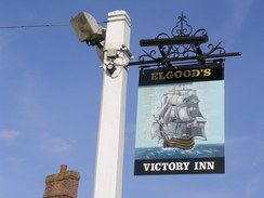
After completing the Fen Rivers Way earlier in the week, I was faced with a plethora of choices about which walk to do next. In the end I chickened out and decided to do another coastal walk - this time the Peter Scott walk, which follows the coast around the southern coast of the Wash. An early start meant that I got to the start of the walk in West Lynn early, despite being delayed being stuck behind a slow-moving lorry. It proved hard to find anywhere decent to park, and eventually I gave in and pulled up on the roadside between the church and he ship.
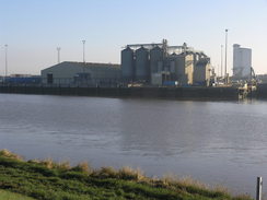
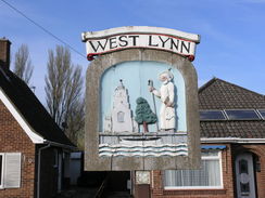
West Lynn just appeared to be waking up from its slumbers as I set off - people were walking to the shop for the morning papers, and workmen were heading towards some new-build houses. It felt quite different in character to King's Lynn, just across the water; much more of a village than a town. I reached the start of the Peter Scott Walk. This is near to the small ferry that takes people across the Great Ouse to King's Lynn. A couple of people were waiting for the ferry, but my route led elsewhere.
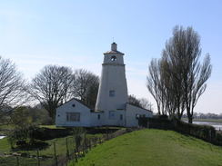
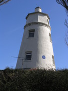
Peter Scott was a painter and conservationist, who managed to clamber out of the shadow of his late father's death in the Antarctic. He was a co-founder of the World Wildlife Fund, and also set up the Wildfowl and Wetlands Trust. He made his home in the lighthouse at the eastern mouth of the River Nene (which marks the end of the trail), and the birdlife visible from the floodbanks means that it is a fitting walk to be named after him.
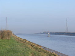
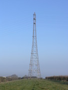
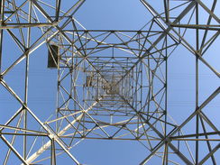
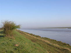
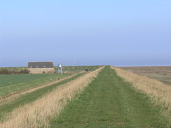
The walk started off ignominiously as I headed in totally the wrong direction between garden fences, eventually realising my mistake as I reached an overgrown area. It was not a long diversion to head back to the track and then the flood bank that I would be following for the next fifteen miles. Initially the way followed the bank north with the Great Ouse on the right; across the river lay the tall chimneys and buildings that surround the docks in King's Lynn. One of the vast pylons that carry cables over the river was obvious through the hazy sunshine ahead, but seemed to take an age to reach.
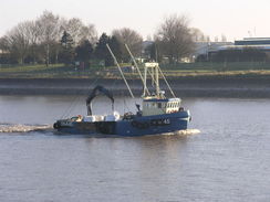
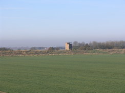
A Grimsby-registered fishing boat plyed its way upstream as I headed in the other direction, and it felt good to see that King's Lynn still has a fishing connection, even if the fleet is far smaller than in its heyday. Soon the banks started curving away to the left, slowly becoming the southern edge of the Wash. A two-storey building became visible slightly inland, looking for all the world like a square Scottish tower castle. As I got nearer its true purpose became clear - it was a classic World War Two battery observation post (part of the Ongar Hill Coastal Defence Battery, complete with concrete roof.
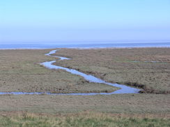
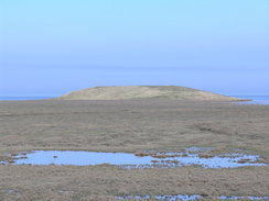
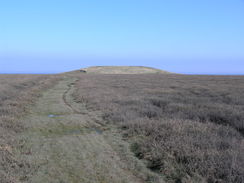
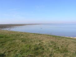
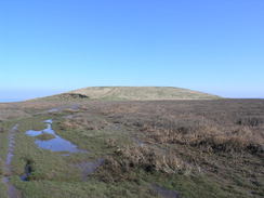
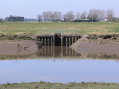
The eastern edge of the Wash coast stretched into the distance behind me, dark and grey, seemingly hovering above the sea like a mirage. At this stage there were surprisingly few seabirds about, but more became visible as I headed westwards. Soon a strange pyramid-shaped landmass became visible on the mudflats ahead, easily higher than the banks that I was walking along. I remembered this from my previous walk in 2002, and watched it grow larger as I approached. Out to sea in the distance was another, similar structure. The islands are the remains of an attempt in the 1970s to convert much of the Wash into a freshwater-storage reservoir. The scheme got no further than the construction of it and the larger island, which is situated two miles out into the Wash and known locally as the 'Doughnut'. Cost was a major issue, as was pollution of the freshwater by salt. This whole landscape has been altered by man - a quick glance of the 1:25,000 OS map shows a series of sea banks inland; 1910, 1917, 1925 and earlier, each one getting nearer to the current bank.
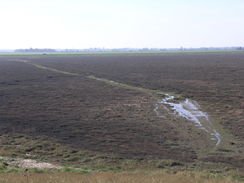
An environment Agency vehicle was parked near the start of the causeway that leads out to the smaller island, and I chatted to the man within for a few minutes. He was involved with work to take electricity cables out to a planned windfarm in the Wash, to join the land-based ones I could see in the distance. On a whim I decided to head out to visit the island, knowing that I would regret it if I did not. Although there were signs of a hard surface in places, the path was very muddy and waterlogged in places. It is certainly not a place to be during a high tide, but there were no such problems today. Once at the island it became a simple job of climbing up the grassy slopes to reach the top. Sadly the views out to sea were remarkably hazy, although I got good views of seabirds on the surrounding marshes. Eventually I decided to head back towards the sea banks and land.
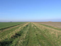
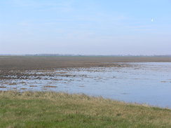
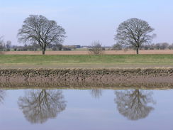
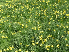
In many ways this long plod along the seabanks, with the sea such a long distance away to the right, should have been boring. Instead I found it to be inspiring, even with the sea so far away. The fields to my left were a muted green, the banks themselves a luscious green and the marshes brown; all contrasted magnificently with the blue sky overhead. I was in my element, and the sun meant that it was a superb day for such a walk.
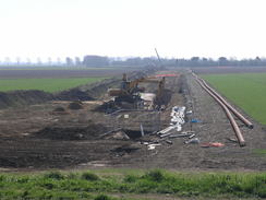
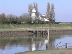
Eventually I reached the corner that marked the point where the Wash meets the mouth of the River Nene. A series of cranes and diggers were working away to my left, presumably on the electric feeder cable I had been told about earlier. A long string of pipes stretched away into the distance, through which I assume the cables will be threaded. Soon afterwards I reached a white lighthouse on the bank, once the home of Peter Scott (there is a similar lighthouse on the other bank of the river).
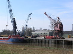
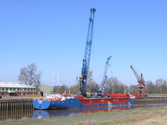
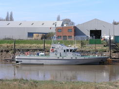
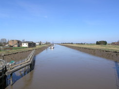
The lighthouse marks the end of the trail named after him, but I wanted to walk on down to Sutton Bridge for a break. Sadly this meant a long, three-mile stroll south along a road, and after a while the reflections in the waters of the Nene soon lost their interest. Just before Sutton Bridge was Port Sutton Bridge. This port lies on the western bank of the River Nene, and I watched a cranes lifted rolls of steel out from a ship. The port itself only opened in 1987, and apparently does a good trade. It certainly appears to be busy every time that I pass.
A little further south was a winding-hole where a national emergency was declared in 2000 because a ship, the Lagik, had sunk in the river. The winding hole is a place where large ships can turn around; they tie their bows against the bank and let the current drag their stern downstream, thus turning them around. Whilst doing this one day the Lagik got caught on the riverbank, and as the tide went out it broke it's back, thus blocking the entire river. When the tide went out once again it broke in half again, leaving the ship in three parts on the riverbed. The cargo had to be unloaded by crane using divers, and then a chain was used to saw the ship into three parts (although it had broken into three parts much of the hull plating was still attached). Then all three parts of the ship had to be lifted out of the river. A Norwegian firm did all this, and I had been in Kings Lynn with Sam one day when we decided to make a diversion to see this. When we arrived we saw the ship lying in the river in three parts, and a flurry of activity as cranes were offloading the cargo. It was a memorable sight, and I still have the pictures of the ship lying broken in the river. The accident report is available on the Marine Accident Investigation Branch website.
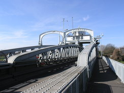
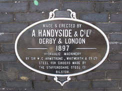
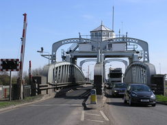
The bridge across the Nene in Sutton Bridge is a spectacular metal swing bridge, It was constructed in 1897 by the Midland and Great Northern railway to allow road and rail traffic cross the river, and was the third bridge at or near this location since the first one was built by Sir John Rennie in 1830. The bridge is hydraulically operated, and opens to allow ships to go up the river to Wisbech. The bridge used to open about 900 times a year, but the opening of Port Sutton Bridge has caused the importance of the port at Wisbech to decline, and now it only opens a few times a week.I have a particular fondness for such structures, and I was pleased to see a plaque stating that it had been built by Handysides, a Derbyshire company.
I stopped off at the New Inn in Sutton Bridge, the same pub that I visited during my coastal walk. It was a friendly place, and I chatted to the landlord and barmaid as I drank and ate. The bar is particularly notable, as it is formed of a series of iron firegrates. Suitably replenished, I recrossed he bridge to the eastern bank, and had a decision to make. It was very tempting to walk back the way I had come, but that would have made it a thirty mile day, a little long for this time of year. There was no good alternative aside from a long plod eastwards along roads. After a little prevarication I decided that the road was the best alternative.
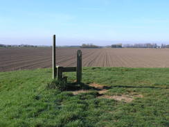
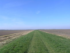
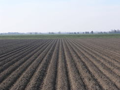
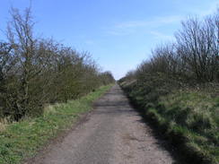
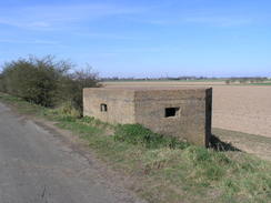
Initially I took a path that ran along the top of a tall bank, with the main A17(T) road off to the right. The path was surfaced and markings showed that it had obviously once been a road, but I found it hard to work out the relationship between it, the modern road below and the railway line that once ran nearby. There was no sign of the railway, so I can only assume that the banking carried the original road, and the railway line had been obliterated by the modern replacement. Some good views from the banking showed exactly how flat the surrounding reclaimed land was, and the two pillboxes I passed must have had good fields of fire.
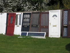
Sadly the banking soon ended, and I was forced to follow roads eastwards through a series of villages. The pub in Walpole Cross Keys had closed, a victim of the recent problems in the brewery trade, as had another one further up the road (although that looked as though it had been closed for decades). A couple were open, however, but I strolled on regardless. The school in Clenchwarton had just come out, and the pavement was busy with children, parents and grandparents. Near West Lynn there was a business selling salvaged items from demolition jobs, and the fence was lined with a series of doors: number 26 next to Number 1, red next to white. It made for a curious look, all doors and no walls. As I approached West Lynn I considered extending the walk slightly by heading down to the Free Bridge over the Great Ouse, after which I could return along the flood banking to the ferry in the village. Tired feet and a good mileage dissuaded me, and I headed back to the car thinking of what had been a spectacular walk along the sea banks, and a distinctly ordinary stroll along roads.
I would like to use this walk to commemorate Katherine (Soud) Talbot-Ponsonby, another coastal walker who lost her battle with cancer last year. I never had the honour to meet her, but I talked to her a few times on the phone. Her book, 'Two feet, four paws' was a constant read on my own coastal walk, and is still the best book about the walk.
 |
 |
|
Directions
This walk starts off at Ferry Square in West Lynn, a short distance away from the ferry landing. Head north up a gravel track called River Walk, and follow it as it swings to the right towards a river bank. Climb up onto the river bank, and follow it northwards with the river on the right. After crossing a stile the path carries on along a wide grassy area; soon a hedge starts on the right. The hedge eventually ends; pass directly under a large electricity pylon, and shortly after a drain outfall on the left (along with a machine to life debris out of the drain), the path crosses a stile to head between two hedges for a short distance before emerging out onto floodbanks once more.
Stay on the obvious large flood bank as it heads northwestwards and westwards; the going and navigation is easy; just keep the mudflats to the right. 11.5 miles after leaving West Lynn, the mouth of the River Nene is reached at TF495266. Here follow the banking as it turns to the left to start following the eastern bank of the river downstream. It soon joins another floodbank, and continues on down towards a lighthouse. Just before the lighthouse is reached, the path drops down to the right to walk along the grassy foreshore, with the river on the right. After the lighthouse is passed, the path turns up to the right to join a road; this marks the end of the Peter Scott walk.
Join the road and follow it southwards for three miles, with the river close-by on the right. Eventually the road ends at a junction with the A17(T) at TF483209. If you wish to visit Sutton Bridge, then turn right to cross the bridge over the river; the village lies directly on the opposite side. If not, then turn around to head north along the road for a few yards from the A17(T) junction. Turn right to go through a barrier to join an old road that heads east-southeastwards, soon climbing up onto a bank called Crosskeys Bridge Bank. Continue on for 1.3 miles, with the A17(T) below to the right.
The bank eventually lowers to end at the junction of Lynn road and the A17(T) at TF502199. Turn left along Lynn Road and follow it as it swings to the right; do not take a road that leads off to the left. Continue along the road for many miles as it winds in a rough easterly direction, passing through Walpole Cross Keys and Terrington St Clement. It leaves Terrington St Clement and cntinues eastwards for another couple of miles, passing through Clenchwarton before eventually approaching the southern outskirts of West Lynn.
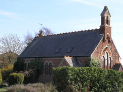
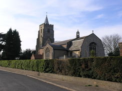
At TF609169 the road curves to head south towards Free Bridge; just after the bend turn left down St Peter's Road. This soon curves to the left to head north through West Lynn. Cotinue as it passes the church on the left, and then crosses the West Lynn Drain. As the road finally curves to the left once more, turn right down Ferry Square to reach the square itself, where this walk started.
Distances
| From | To | Distance (m) | Ascent (ft) | Descent (ft) |
|---|---|---|---|---|
| West Lynn | Breast Sand island | 7.6 | 52 | 65 |
| Breast Sand island | Sutton bridge | 7.5 | 10 | 10 |
| Sutton bridge | Terrington St Clement | 4.8 | 16 | 7 |
| Terrington St Clement | West Lynn | 4.4 | 20 | 16 |
This makes a total distance of 24.3 miles, with 98 feet of ascent and 98 feet of descent.
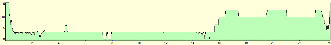
For more information on profiles, ascents and descents, see this page
 |
 |
|
 |
 |
|
 |
 |
|
 |
 |
|
 |
 |
|
 |
 |
|
 |
 |
|
 |
 |
|
 |
 |
|
 |
 |
|
 |
 |
|
 |
 |
|
 |
 |
|
 |
 |
|
 |
 |
|
 |
 |
|
 |
 |
|
 |
 |
|
Disclaimer
Please note that I take no responsibility for anything that may happen when following these directions. If you intend to follow this route, then please use the relevant maps and check the route out before you go out. As always when walking, use common sense and you should be fine.
If you find any information on any of these routes that is inaccurate, or you wish to add anything, then please email me.
All images on this site are © of the author. Any reproduction, retransmissions, or republication of all or part of any document found on this site is expressly prohibited, unless the author has explicitly granted its prior written consent to so reproduce, retransmit, or republish the material. All other rights reserved.
Although this site includes links providing convenient direct access to other Internet sites, I do not endorse, approve, certify or make warranties or representations as to the accuracy of the information on these sites.
And finally, enjoy your walking!
Nearby walks
| # | Title | Walk length (miles) |
|---|---|---|
| 4 | Downham Market to Watlington | 6.2 |
| 28 | Kings Lynn to Watlington | 7.4 |
| 156 | Kings Lynn to Snettisham | 14.6 |
|
|

|