Walk #887: Littleport to Kings Lynn
 |
 |
|
General Data
| Date Walked | 21/03/2011 |
| County | Cambridgeshire, Norfolk |
| Start Location | Littleport Station |
| End Location | Kings Lynn Station |
| Start time | 06.50 |
| End time | 16.25 |
| Distance | 26.6 miles |
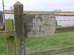
| Description | This was a pleasant and flat walk following the Fen Rivers Way north towards the sea, along with a little extension to the north. |
| Pack | Today I carried my 30-litre Karrimor rucksack, filled with water, my waterproofs, a couple of books and other odds and ends. |
| Condition | I feel absolutely fine after this walk, with no problems to report. |
| Weather | The day was mostly cloudy, with some sunny brief periods. It was a surprisingly warm day for the time of year, and the slight breeze was welcome. |
| OS map | Landranger number 143 (Ely & Wisbech, Downham Market), Landranger number 131 (Boston & Spalding) and Landranger number 132 (North West Norfolk, King's Lynn & Fakenham) |
 |
 |
|
Map of the walk
Maps courtesy of Google Maps. Route for indicative purposes only, and may have been plotted after the walk. Please let me have comments on what you think of this new format. For a detailed table of timings for this walk, please see the table file.
 |
 |
|
Notes
After last week's walk along half of the Fen Rivers Way, it seemed like a good idea to walk the other, northern half. This would mean a long twenty-four mile day, but with the options of stopping earlier if I wanted at Downham Market or Watlington. It was going to be a long day for this time of year, and so I set off early in the morning for the drive to Littlleport.The weather was not as promising as it had been on the previous walk, with not much sun visible through the cloud. There was no sign of any rain, however, so I was looking forwards to a long and interesting walk.
Annoyingly, the parking tickets for the car park at Littleport station can only be got through the ticket machine, and this did not take coins. A slight queue built up as I paid with my debit card - whilst this means that the railway company do not need to bother with troublesome coins, it is far from good for their customers.
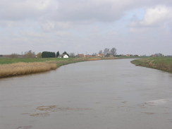
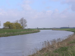
The first couple of miles followed the floodbank that was trapped between the Great Ouse on the left and the A10 on the right. Despite the views over the river, it was hardly the best walk I have ever done, and it was easy to remember why I have only ever done this stretch of the Fen Rivers Way once before. Traffic roared along the main road below me, only being held up by the occasional tractor. The low-lying nature of the land was clearly visible, with the rich soils of the fields being well below the level of the river. One breach in the substantial banks would surely flood thousands of acres of those fields.
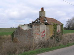
A burger van sat in the large lay-by to the south of Brandon Creek, so I nipped down to buy myself a greasy baguette to eat. I munched on this as I walked on along the bank past the Ship Inn, which is situated in a pleasant spot where the Little Ouse flows into the Great Ouse. The unremarkable concrete bridge over the Little Ouse had a pavement, but this ended on the other side, forcing me to rejoin the river bank once more for a shirt distance until a road led away from the A10. A solitary house on the right was boarded up, seemingly recently, a strangely sad sight.
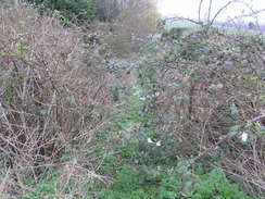
The minor road rejoined the A10, and this time I could not walk along the banking, Instead there was a reasonably wide verge on the tarmac as the road approached some houses. Fortunately the Fen Rivers Way soon headed off between houses to the left to rejoin the floodbank; unfortunately the path was very overgrown with brambles at the top, and it took me a couple of minutes to force my way through. It is a shame that a named path should be so badly overgrown, and this short stretch has obviously not been walked for some time.
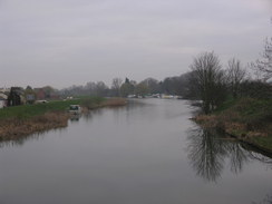
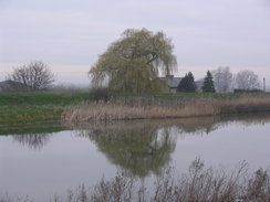
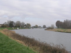
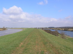
Fairly soon the river and floodbank headed away from the main road, entering a classic Fenland landscape. Billiard-table flat fields stretched away in all directions, all seemingly below the level of the river. Before last week's I had been concerned that the severe winter weather would have made the banks wet and muddy; in the end there was nothing to worry about, and the going was very firm and good.
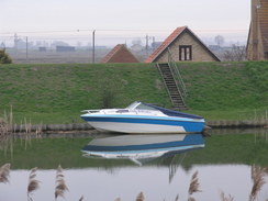
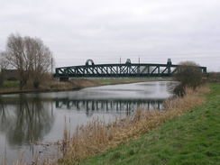
Eventually Hillgay Bridge was reached, where a minor road crosses the river. Here the Way transferred over to the western side of the river, and continues along the floodbank with a minor road to the left. Indeed, at times the minor road was actually on top of the bank, so it seemed sensible to walk along that instead of along the floodbank. Soon the road dived to pass under a green steel bridge that carries the King's Lynn railway line over the river, before continuing on to approach Denver Sluice. A fair few boats were moored on the approaches, and the vast metal structures of the sluice contrasted well with the boats and tree-lined banks.
Denver Sluice is perhaps the most important component of the areas' defences against the sea. Much of the surrounding low-lying land of the fens - stretching nearly as far south as Cambridge - was once flooded, either periodically or permanently. This led to a way of life for the local Fensmen that came to an end when schemes started to drain the land for farming. The monastaries started this process, but it really took off when a Dutchman, Cornelius Vermuyden, got involved. The Old Bedford River was constructed first, a twenty-mile long arrow-straight river stretching from Earith to the sluice. This cut many miles out of the route of the Great Ouse, and allowed easier drainage. In the 1640s Vermuyden built the parallel New Bedford River, also known as the Hundred Foot Drain, The land between the Old and New Bedford rivers could (and still are) used to store flood waters in winter, relieving pressure on the rivers. Unfortunately the drainage led to the peat shrinking, meaning that the land slumped to well below sea level and often flooded. The waters have only been fully controlled over the last century.
The sluice marks the place where the Old and New Rivers, along with other drainage scheme, meets the Great Ouse. The lock is also the first lock I had seen since Waterbeach, showing how level the surrounding land is. It is an impressive structure, the boat lock only being a small part of it. As expected the adjacent pub was not yet open, so instead I plodded on along the Way, which now followed the eastern bank of the Ouse. There was another difference: a wide, straight river off to the right, the Relief Channel. This 6.5-mile long river was built in the 1960s, and a lock was opened to make it accessible to boats in 2001. Being trapped between the two rivers felt slightly strange, as if the land between was only temporarily dry.
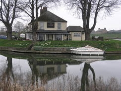
Downham Bridge was soon reached, and the Way continued north along the eastern bank. Downham Market lay a short distance away, and on a previous walk twelve years ago I had used the station to travel back to Litttleport. I am a lot fitter nowadays, and I was only halfway through the walk, so I pressed on. Another couple of miles took me to Stowbridge, where I once met at ex-girlfriend. By this time I was in need of a break, and it was a shame that the pub at Stowbridge did not open on Mondays until much later in the day. It was a particular shame as we had shared our first drink together in that very pub...
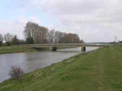
A long walk followed, still following the eastern bank of the river. The only real item of interest was an old railway bridge over the Relief Channel to the right. This was part of the Wisbech to King's Lynn railway line that closed in 1969. Strangely the bridge over the Relief Channel - built shortly before the line closed - is still extant, but the adjacent bridge over the Ouse is long gone. I walked on to reach the next bridge over the river, Magdalen Bridge. I could see a pub on the other side of the river near the church, but there was a 'for sale' board high on the wall, not a good sign. I walked past this and to the nearby post office, which unfortunately was nearly empty of stock. The owner told me that the pub was open, so I went in.
Immediately I felt as though I had been transported back twenty years. It was what I would call a typical drinkers' pub, with a corresponding decor. Only the lack of cigarette smoke spoiled the illusion. The barman and only customer were both friendly, and I chatted to them as I drunk my pints; the barman was kind enough to fill up my water bottle. Most of the pubs I visit nowadays are modern gastro pubs, all faux-atmosphere and good, solid but characterless food. It felt good to be in a pub that felt genuinely old-fashioned. Then again, the 'for sale' sign points at it perhaps being uneconomic as well.
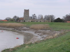
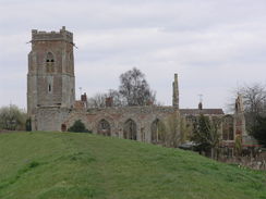
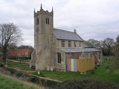
Suitably refreshed, I strode on along the river. A sewage works was soon passed, leading me to wonder why it was situated in such a strange place between the two rivers instead of on either bank. A little further on came what was perhaps the highlight of the day - the ruined church of Wiggenhall St Peter. It is remarkably complete when compared to most ruined churches, and scaffolding showed that it was still being cared for. Indeed, from a distance it looks as though you would only need to add some glazing and a roof for it to be complete.
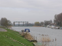
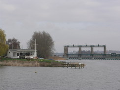
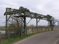
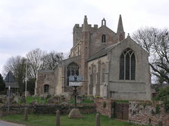
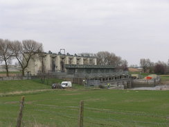
The Way passed a similar-styled church at Wiggenhall St Germans, which is situated near to another pub. The Way is well signed on this northern stretch, with information boards giving lots of information on the trail. I was getting slightly fed up with the unchanging scenery beside the river, and it was therefore a relief when I reached the sluices that guard the northern end of the Relief Channel. Men were working below the large structures, and I jumped as a speaker blared out a warning as I passed; it is an automated system, perhaps more likely to cause heart attacks than save people.
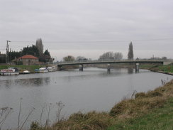
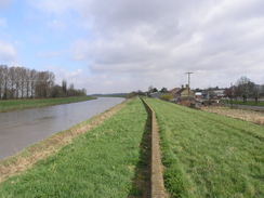
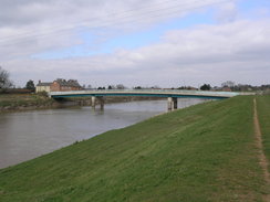
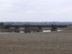
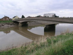
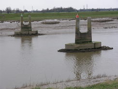
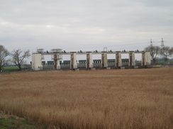
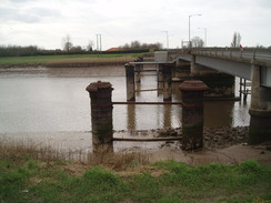
This marked the end of the rural stretch of the walk, and the start of a more industrial area. A paved cycle path took me onwards, initially past an attractive area of reeds before rejoining the floodbank once more. Massive industrial buildings loomed to my right; these were modern in design and nothing like the bleak - if sometimes beautiful - Victorian buildings. The A47(T) dual carriageway flew over on a concrete bridge, and shortly afterwards I reached the Free Bridge. This was a fairly ordinary structure, but I was more interested in some piers - possibly cast-iron - that protruded from the water. These were either part of an earlier road bridge, or of the bridge that carried the King's Lynn to Sutton Bridge railway line over the river. Whichever it was, even in poor condition they were of more interest than the road bridge.
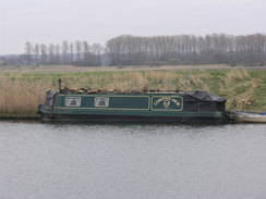
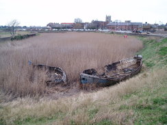
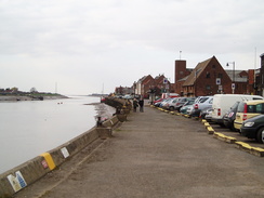
The cycle path continued on along the river, eventually reaching the mouth of the River Nar. This is the start of the Nar Valley Way, another walk that I want to do at some time in the near future. There were some road works going on, and I skirted an area of marshland to reach Boal's Quay. A couple of fishing vessels were tied up at the quay, a sad sight given that boats used to be moored three abreast within living memory.
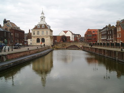
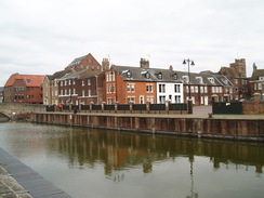
I enjoyed the stroll along the quayside, now used as parking for cars rather than boats. The end of the Fen Rivers Way was marked by another information board, right by a metal sculpture of fish and other objects. Now all I had to do was walk to the railway station for a train back to Littleport, but I was still feeling fit so I decided to extend the walk. After passing the superb Custom's House and the Tuesday Marketplace, which is surrounded by grand buildings, I headed out northwards.
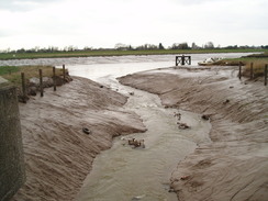
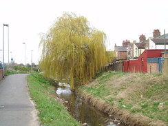
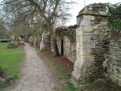
My initial plan to head further along the eastern bank of the Ouse towards the Wash was abandoned, and instead I took a looping walk, following a stream that arced through North Lynn. I have visited King's Lynn on many different occasions, but had never explored much of the town outside the centre. Unfortunately I was greeted with a stream filled with litter; old bags of rubbish and the obligatory shopping trolleys. Frankly, the litter made it feel like not a particularly pleasant area. Indeed, I decided to cut this walk extension short and returned along roads and paths, passing the ruins of the old Town Wall to reach the station.
I sat down on the train and looked back at what had been an interesting day's walk, my first marathon walk (i.e. over 26.2 miles) for some time. It also marked the end of my two-day stroll along the Fen Rivers Way, which had been a surprisingly pleasant (if flat) stroll. All in all it had been a good way to reintroduce myself to Cambridgeshire.
 |
 |
|
Directions
This walk starts off on the road immediately to the south of Littleport railway station at TL574873. Turn right and follow this road as it heads in a rough north-northeasterly direction for a third of a mile until it reaches the A10(T). Turn right to cross the river via the bridge, and before a roundabout is reached turn left to join another footpath that follows the top of the floodbank northeastwards for 3.2 miles, trapped between the river on the left and the A10(T) on the right. The path eventually reaches Brandon Creek at TL607917. It then continues along the floodbank as it passes in front of the Ship Inn, before following the pub's driveway to return to the main road.
Join the main road and use the road bridge to cross Brandon Creek. Once on the northern side continue on for about fifty yards until a minor road leads off to the left (it is safer to walk this stretch along the top of the bank on the left than along the road). Turn left and follow the minor road as it skirts the eastern bank of the river northwards before rejoining the main road a little over half a mile later. Continue on northwards along the road; there is no pavement, but the verge is wide enough to safely walk this stretch. Just before Sedge Fen Road comes in from the right, the path turns left to rejoin the floodbank, squeezing along a narrow path between gardens; this path was very oergrown when I last walked the path in 2011. If it is still overgrown, the you can continue along the A10(T) for a short distance before joining the floodbank. Continue on the floodbank with the river on the left; it soon curves away from the main road. After 2.7 miles a road is reached beside Hillgay Bridge at TL604970.
Turn left along the road to cross the river on a bridge, and then turn right to start following the banking, with a minor road on the left, in a rough north-northwesterly direction. At times the road runs along the bank, so it may be easier just to walk along the road. When a railway bridge is reached the bank leave the bank and join the road, rejoining the bank shortly after White House Farm. Continue on along the floodbank; Denver Sluice at TF587009 is reached nearly three miles after Hillgay Bridge.
Follow the bank and road past the Jenyns Arms and use the road to cross the sluice. On the other side turn left to join a footpath that follows the eastern bank of the river in a rough northerly direction for 1.4 miles until the A1122 is reached beside Downham Bridge at TF597029. Downham Market railway station is half a mile to the northeast along the main road.
This leg starts off on the A1122 road at TF597029, half a mile to the southwest of Downham Market. Do not cross the river at Downham Bridge, and instead follow a footpath that runs along the eastern floodbank of the river, passing between the river and some houses on the right. After 2.7 miles it crosses a road to the west of Stowbridge (with the Heron pub a short distance to the right) and continues on for another 2.8 miles, reaching a road beside Magdalen Bridge at TF600113, to the northeast of Wiggenhall St Mary Magdalen. Cross the road and continue on for another couple of miles, passing a sewage works and close to the ruined church of Wiggenhall St Peter before reaching another road at TF596140, close to Wiggenhall St Germans church and the Crown and Anchor pub.
Cross the road and continue on along the eastern river bank as it heads in a rough northerly direction for another couple of miles until it reaches a sluice over the Relief Channel at TF604172. Cross the bridge beside the sluice to reach the eastern bank of the channel. Turn left to join a surfaced cycle path; follow this past some reed beds on the left. Do not head towards the power station to the south. The path soon rejoins the eastern bank of the river; after 0.8 miles it passes under the A47(T).
The path continues on northeastwards for a few yards to another road next to the Free Bridge over the river; on the other side continue on northeastwards along the cycle path for 0.6 miles until a bridge over the mouth of the River Nar is reached at TF617192. Cross the bridge and continue along a cycle path on the other side; after a short distance turn left along another footpath that runs along the northern bank of a channel to reach Boal's Quay. At the quay, turn right to cross a bridge over an inlet and continue along the quayside. The Fen Rivers Way ends on the Quay at TF616197.
From here, you can walk directly towards King's Lynn railway station. Continue north along the quayside; when the Purfleet is reached on the right, cross a bridge over the water and then immediately turn right, to walk along Purfleet Quay that heads towards, and then past, the beautiful Customs House. When Purfleet Quay ends at King Street, turn right and then immediately left to follow Purfleet Street eastwards. As this curves to the left, continue straight on along a pedestrianised road. This becomes New Conduit Street, and then Blackfriars Street. This reaches the A148; carefully cross this and follow Blackfriars Road eastwards; it soon curves to the left to head northwards. King's Lynn railway station is a short distance north at TF622200.
However, I took a much longer route to the station. Continue north along the quayside; when the Purfleet is reached on the right, cross a bridge over the water and then immediately turn right, to walk along Purfleet Quay that heads towards, and then past, the beautiful Customs House. When Purfleet Quay ends at King Street, turn left to follow King Street northwards until it reaches the large expanse of the Tuesday Market Place (also used as a large car park), which is surrounded by Georgian buildings. Keep the car park on the right, and at the northern end turn right to head eastwards along St Nicholas Street.
When this ends at a T-junction turn left up St Ann's Street, passing a large church on the right. Follow this road as it curves to the right, becoming North Street, until this ends at another junction with John Kennedy Road. Turn left to follow this road northwards; it crosses an old railway level crossing before swinging to the left. As the B1148 comes in from the right, turn right up the B1148 and them immediately left to join a cycle path that runs along with a drainage channel on the right (signposted for 'The Wootons'). Follow this north-northeastwards for just under half a mile until Losinga road is reached at TF623211.
Turn right and follow this road as it winds southwards through a housing estate; after passing an area of grass on the right, turn right down Edma Street, and then left down Townshend Terrace, with a broad stream on the right. Continue with the stream on the right until the B1148 is reached. Cross the road and continue southwards along Harecroft Parade. This becomes a path that crosses an old railway line (now a grassy area) and continue as the path curves around, with a stream a short distance away to the left. When the A148 is reacehd turn right, and follow it as it curves to the left to head southwards. King's Lynn railway station is a few hundred yards away on the left.
 |
 |
|
Distances
| From | To | Distance (m) | Ascent (ft) | Descent (ft) |
|---|---|---|---|---|
| Littleport station | Hillgay bridge | 7.7 | 102 | 105 |
| Hillgay bridge | Downham bridge | 4.4 | 56 | 52 |
| Downham bridge | Wiggenhall St Mary Magdalen | 5.8 | 49 | 49 |
| Wiggenhall St Mary Magdalen | King's Lynn station | 8.7 | 121 | 108 |
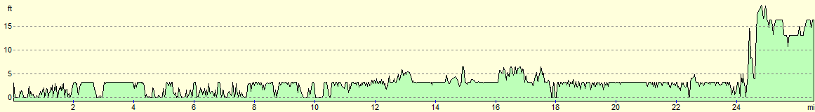
This makes a total distance of 26.6 miles, with 328 feet of ascent and 314 feet of descent.
For more information on profiles, ascents and descents, see this page
Transport
Regular train services run between King's Lynn and Littleport, calling at Watlington, Downham Market and (occasionally) Denver sluice as well.
 |
 |
|
 |
 |
|
 |
 |
|
 |
 |
|
 |
 |
|
 |
 |
|
 |
 |
|
 |
 |
|
 |
 |
|
 |
 |
|
 |
 |
|
 |
 |
|
 |
 |
|
 |
 |
|
 |
 |
|
 |
 |
|
 |
 |
|
 |
 |
|
 |
Disclaimer
Please note that I take no responsibility for anything that may happen when following these directions. If you intend to follow this route, then please use the relevant maps and check the route out before you go out. As always when walking, use common sense and you should be fine.
If you find any information on any of these routes that is inaccurate, or you wish to add anything, then please email me.
All images on this site are © of the author. Any reproduction, retransmissions, or republication of all or part of any document found on this site is expressly prohibited, unless the author has explicitly granted its prior written consent to so reproduce, retransmit, or republish the material. All other rights reserved.
Although this site includes links providing convenient direct access to other Internet sites, I do not endorse, approve, certify or make warranties or representations as to the accuracy of the information on these sites.
And finally, enjoy your walking!
Nearby walks
| # | Title | Walk length (miles) |
|---|---|---|
| 3 | Littleport to Downham Market | 14.0 |
| 4 | Downham Market to Watlington | 6.2 |
| 18 | Waterbeach to Ely | 10.9 |
|
|

|