Walk #588: Grindleford to Brough via the eastern edges
 |
 |
|
General Data
| Date Walked | 26/01/2004 |
| County | Derbyshire, South Yorkshire |
| Start Location | Grindleford Station |
| End Location | Brough |
| Start time | 08.37 |
| End time | 17.14 |
| Distance | 23.0 miles |
| Description | This was a lovely walk over the eastern edges of the Peak District; unfortunately most of the views were obscured by the cloud layer that I was walking in for most of the time. |
| Pack | Today I carried my 30-litre Karrimor HotRock rucksack, which was filled with my waterproof leggings, water bottle, trainers and a couple of spare shirts, together with the usual assortment of odds and ends. |
| Condition | I feel absolutely fine after this walk, aside from a little fatigue that is to be expected. I could have walked further if I had needed to, which was surprising after such a long walk. |
| Weather | The day was spoilt somewhat by low cloud cover, that prevented me from getting any nice views on the edges. There was not much wind to bother me and it was mostly dry, aside from a little sleet towards the end of the day. The sun did only made one brief appearance when I was on Win Hill - all in all it could have worse, but it could also have been much better. |
| OS map | Outdoor Leisure number 24 (The Peak District - White Peak Area) and Landranger number 110 (Sheffield & Huddersfield, Glossop & Holmfirth) |
 |
 |
|
 |
 |
|
Map of the walk
Maps courtesy of Google Maps. Route for indicative purposes only, and may have been plotted after the walk. Please let me have comments on what you think of this new format. For a detailed table of timings for this walk, please see the table file.
 |
 |
|
Notes
I was well aware that today was going to be one of the last opportunities to do a walk before I move down to Cambridge to start my new job, and so I was keen to do an epic. I was prevented to do one yesterday by family commitments, so after a quick cup of coffee this morning I loaded up my car and set off on the long drive up to Grindleford, where I had decided to start the walk.
Once I got there I noticed that the cafe was not yet open (a great shame), before nipping down onto the station platform to get the train times back from Hope. I then set off up the steps that leads up the B6521 road; a steep climb for legs that were not yet warmed up. I did not fancy walking along he road, so a few yards up the road I took a lovely little path that led through the glen to the west of the road. The path led through a nice wooded glade, with Burbage Brook running gloriously below. Eventually the path ended back at the road, and I reluctantly joined it (there was fortunately a pavement alongside the road) and walked up to the A6187 road near the Fox House Inn.
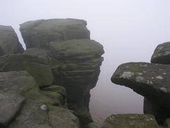
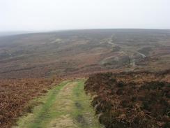
A quick walk down the A6187 led me to the start of the walk along the edges. Unfortunately it also marked the entry to the cloud layer, which I was not to leave for many miles, and prevented me from getting any of the wonderful views that there should have been. I headed north along Burbage Edge, the wind-sculpted rocks making fantastic shapes, only revealing themselves at the last moment through the mist. It was an exhilarating walk, and I was annoyed when the Hathersage to Rinninglow road interrupted the walk for a short distance.
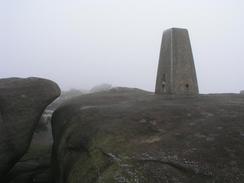
Another path led me to the trig point on the edge near the Cowper Stone; again views were non-existent and I did not hang around as the wind was very chilly. A few yards further on along the edge (which was now Stanage Edge, a famous climbing location) I stopped as I came across a Red Grouse standing on the path in front of me. It looked at me, and I returned its gaze. I slowly got my camera out, and it still did not budge. I decided to zoom in on it, and as soon as I did so it flew off - the end result, no photo, but a magnificent view of a beautiful and usually shy bird.
The path along Stanage Edge was like a pedestrian motorway - wide, and easy to follow. It was also quite muddy in places, and I could not help but get my trouser legs well and truly covered in mud. It was a real shame that the cloud cover was so great - the views should have been marvellous. Eventually I reached the trig point at High Neb - at 458 metres, the highest point on Stanage Edge. The trig point was surrounded by thick and oozing peaty mud, although it was easy to find a safe route towards it. After this the edge started to slowly decrease in height, and the A57 became audible long before it became visible. As the path descended I passed out of the cloud layr, and I finally got some good views just when the views were not as good as they were a mile back along the path!
Once on the A57 I turned left and followed it downhill to the west for a few hundred yards, before turning right up a road that leads north across Strines Moor. I did not follow this road for long before turning off to the left and heading across a boggy area of ground and climbing uphill towards Derwent Edge. I was amused to see a sign here stating that the footpath headed to Derwent. The sign was erected in 1933, and the village has since been obliterated by the Ladybower Reservoir. No traces now remain of the village, church or hall, although at low tide the foundations of them can be seen. For years the church tower remained sticking above the surface of the water, but this too was demolished as souvenir hunters had slowly been removing pieces of stone, leaving it in an unsafe condition. The path passed a series of shooting butts as it climbed, and near the place where it joined Derwent Edge I re-entered the cloud layer.
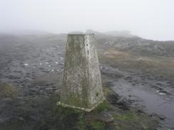
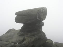
The path along Derwent Edge was again like a motorway, wide and in places muddy, churned up by the thousands of feet that had passed along. I was slightly shocked when the large stone blocks of the Wheel Stones emerged from the mist in front of me - I had not seen them until the last moment. I was also surprised to see two people eating their lunch in the shelter of the lee of the rocks. On the high ground today I only saw five people, which was not surprising given the weather. I had a quick chat to them about where they were walking, before continuing on along the path. The path was in places muddy, and I was glad when I could join a stone causey near Dovestone Tor instead of ploughing on through the mud. Eventually I reached the trig point at Back Tor, which is located on the top of a large stone outcrop. I climbed up to the top of the tor to gain access to the trig, where there should be some superb views; sadly all I could see was the mist swirling around in front of me.
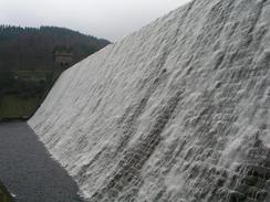
I did not hang around at the trig point as it was quite chilly, so I set off on the path that headed to the northwest, following the Derbyshire / South Yorkshire border. At Lost Lad I passed a viewpoint that was still in the mist, but shortly after this I descended below the cloud layer and could get some nice, desolate view over the moorland. Shortly afterwards I reached Abbey Bank, and a steep descent down to the eastern side of Derwent Reservoir. Here a broad track took me on to the Derwent Reservoir dam, which had a sheet of water cascading down its face, a dramatic sight with the white water contrasting starkly with the dark brown of the dam wall. I soon crossed over the River Derwent near the outfall of the dam and made my way to Fairholmes car park. A steep climb then followed through forestry land to the Lockerbrook Farm; I had not got far, however, before I came across a sign stating that the path was closed due to forestry work. This caused me to hesitate for a short period before I decided to go ahead carefully, and when I passed a forester who was marking trees ready for cutting down I stopped to have a chat for a while.
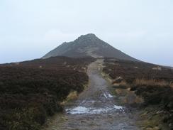
Once at Lockerbrook Farm I joined a track that skirted downhill before joining a footpath that descended steeply past Hagg Farm to the A57 road. Another path took me down to a bridge over the River Ashop, and then started the last climb of the day. The path headed uphill through another forested area before emerging out into a track (an old Roman Road). This took me southeastwards past the Hope Cross, a simple stone monument marking local places, towards Wooler Knoll. The shape of Win Hill lay tantalisingly in front of me, but I was mindful of the fact that there was a train at 16.36, which I would possibly miss if I climbed this last hill.
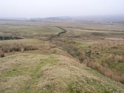
I have never been up Win Hill before, and as I approached it from the long, slow climb up Hope Brink I was surprised to see how rocky and craggy it was. The cloud layer had lifted from earlier in the day and I got a fat better views than I had from the eastern edges, and for a few minutes there was even a patch of blue sky above. The climb up to the trig point at the top of the hill was easy enough, a path passing to the southern side of the crags and was easier than it looked from a distance; the views from the top were exceedingly expansive even in the gloomy weather. I wanted to explore a little bit more, but I was still hopeful of being able to catch the 16.36 train from Hope, so I started the long descent down to the station.
The going was muddy as I started along the track near Twitchill Farm (a ruined barn marking the start of the track), and the sun was starting to go down, leaving a red sky to the west over Castleton. I eventually reached the station fifteen minutes after the train had gone, and was disappointed to see that another one was not due until 18.10. I did not fancy waiting on the station for eighty minutes, and as I felt fit I decided to walk on along the main road to Bamford, where I could get the same train. I walked eastwards along the main road (fortunately there was a pavement beside the road), but when I reached The Rising Sun Inn between Brough and Bamford I came across a bus timetable on a post. A bus to the Fox House Inn was due in a few minutes, and I decided that instead of waiting around for a train at Bamford I would catch the bus and walk for the last mile and a half down to Grindleford. This worked out quite well, and I was glad that I had my head torch as I walked along the B6521 road. I eventually reached my car at 18.10, the extra walk having taken the day's total to nearly 25 miles, with a very satisfying 4,259 feet of climb.
Directions
This walk starts off at the cafe at Grindleford railway station. Climb up to the cafe in the old station building, and then turn right for a few yards past the building before turning to the left to climb uphill along a surfaced footpath. Once the path ends at the B6521 road turn left and walk past a cottage; on the far side of the cottage turn left along a footpath that heads northwards for some woodland; keep Burbage Brook to the left and do not be tempted to descend down to meet it. After a kilometre the path meets the B6521 road once again, and at this point join it and follow it as it heads uphill to the northeast. When the B6521 road ends at a T-junction with the A6187 road turn left and head northwestwards down the A6187 for a few hundred yards.
Just before the road passes over Burbage Brook turn right up the first of two adjacent footpaths; follow this footpath as it heads northeastwards for a short distance, climbing uphill onto the top of the escarpment called Burbage Rocks. Follow the edge of the escarpment northeastwards and then northwestwards, until it finally ends at the Hathersage to Ringinglow road. Turn left down the road and follow it westwards, passing a bridge over Burbage Brook and a car park. When the road turns sharply to the left continue straight on along a distinct path that heads westwards across the moorland. When another escarpment is reached after a kilometre climb up onto the rocks via the obvious path and turn left to reach a trig point.
Once at the trig point turn right and follow the obvious path that heads northwestwards along Stanage Edge. The route is well-walked and obvious, and even in bad visibility like today it is east to follow; be warned, however, that there are steep drops off the escarpment to the left for the unwary. The path passes the trig point at High Neb, where it turns to head in a northerly direction to Stanage End. A short distance beyond here the path became slightly less distinct and turned to head eastwards; continue on another path slightly east of north as the land lowers as it approaches the A57 road. Once at the A57 road turn left and follow it downhill for a few hundred yards until a road junction leads off to the right; turn right down this road for a few yards until a cottage is reached on the left.
At the cottage turn left along a track that leads downhill. Just before a stream is reached and the track curves to the right, turn left along a footpath that follows the stream for a short distance across some boggy land before heading westwards and crossing some hummocky ground to reach a gate beside a wall. Cross a stile over the wall and take an obvious track that leads off uphill to the west. The path descends to cross Highshaw Clough before climbing up the other side past a Grouse butt; shortly after this the path leaves the track to the left, continuing to climb up to the west. Eventually the path reaches a crossroads with the path that runs along the top of Derwent Edge; there is an obvious footpath sign here that marks the junction.
Once Derwent Edge is reached turn right to start the walk northwards along Derwent Edge. The path is easy to follow as it passes the Wheel Stones, White Tor, and Dovestone Tor. Here the path becomes a stone slab causey, which can be followed northwards all the way to the trig point at Back Tor. Immediately before Back Tor the stone slab causey splits; take the path off to the left that skirts the trig point, heading northwestwards to the cairn and viewpoint marker at Lost Lad. Continue on for another couple of hundred yards to Lost Lad Hillend where a rough track is joined. Follow this track westwards for a few hundred yards before turning off down a rough and indistinct footpath to the southwest across the moorland.
The footpath merges with another one and turns to head in a more westerly direction. When a crossroads is met with another footpath continue on to the southwest, taking a footpath that heads steeply downhill before entering some woodland and ending at the track that runs along the eastern shore of Derwent Reservoir. Turn to the left and follow the track southwards alongside the reservoir past Hollin Clough until Derwent Reservoir dam is reached. Walk past the large stone gateway leading to the dam wall, and then immediately turn to the right down some steps that lead down to the flat area of land in front of the dam. Walk southwestwards across the grass to reach a road beside the bridge over the dam outfall, and then turn right to cross the bridge.
Follow the road as it swings to the left and reaches a roundabout with the entrance to the Fairholmes car park. Here head straight on up a bank to the west to meet a track; there is no footpath here, but it is only a fifty yard uphill stroll through some brush land to gain access to the track. Turn left and follow the track as it heads southwards for a short distance before it turns sharply to the right to head uphill to the west through a forested area. The concessionary path uphill is well marked; follow this all the way uphill until it ends at a track immediately to the north of Lockerbrook Farm. Turn to the right and follow the track past the farm until it curves sharply to the right; here continue straight on along another track that heads steeply downhill to the southwest, passing near to Hagg Farm before reaching the A57 road.
Cross the A57 and take another footpath that descends down to a bridge over the River Ashop. Cross the bridge and on the other side turn right to join a track that heads into a forested area. A few yards up the track turn to the left and take another track that climbs uphill to the south; it soon climbs above the trees and reaches a crossroads with another track. Here turn to the left and follow an old Roman Road southeastwards to the Hope Cross, and old guidepost on the moors. Continue along the track as it slowly heads away from the woodland; as it nears Wooler Knoll take another path that leads off to the left, climbing uphill back towards the woodland. Just before it reaches the woodland turn to the right along a track that heads southeastwards.
Just before Thornhill Brink is reached follow the track as it curves to the left to head in a more easterly direction for a kilometre up to the trig point at the summit of Win Hill. Once at the trig point retrace your route back to the west for a couple of hundred yards, and then turn left along a footpath that heads steeply downhill to the southwest. Just before Twitchill Farm is reached turn left across a field towards a wooded glade; by the glade the path becomes a track that can be followed down to Edge Farm. Here the track becomes a road that heads downhill to the south before ending at a road in Aston. Turn to the left and then immediately to the right, to head south along a footpath beside a stream. When the path finally meets the railway line turn right along a path that leads to the footbridge beside Hope Station.
If you want to walk further than Hope than cross the footbridge and once on the other side turn left along a minor road; go through a gate and past a factory until a roundabout is reached. At the roundabout turn to the right for a few hundred yards until the road ends at a T-junction with the A625 Hope Road. Turn to the left and follow Hope Road as it heads eastwards; there is a pavement beside the road that makes the walk far safer, particularly in the dusk that was approaching as I walked it. This walk ends a couple of kilometres down the road at the Rising Sun Inn, between the villages of Brough and Bamford. The railway station at Bamford is a little over a kilometre further down the road if you wish to catch a train back to Grindleford from there.
Distances
| From | To | Distance (m) | Ascent (ft) | Descent (ft) |
|---|---|---|---|---|
| Grindleford Station | High Neb trig point | 6.8 | 1827 | 922 |
| High Neb trig point | Derwent Reservoir dam | 8.3 | 1138 | 1818 |
| Derwent Reservoir dam | The Rising Sun, Brough | 7.9 | 1650 | 1936 |
This makes a total distance of 23.0 miles, with 4615 feet of ascent and 4676 feet of descent.
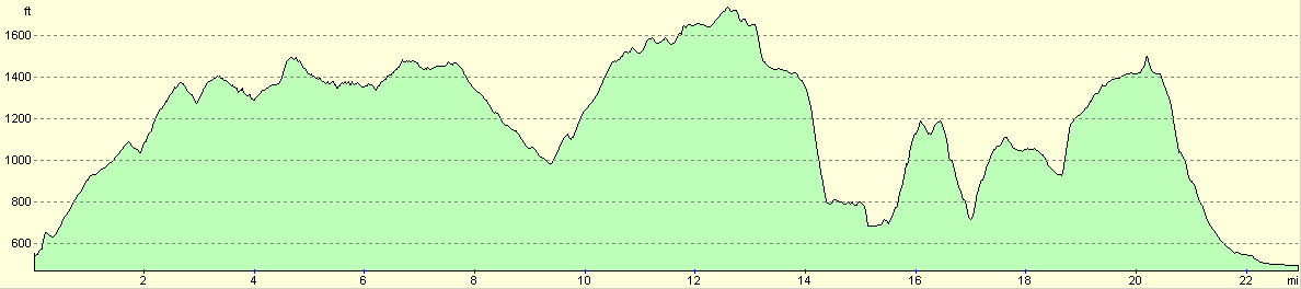
For more information on profiles, ascents and descents, see this page
Transport
There are train services from Hope or Bamford back to Grindleford; these run at two-hourly or hourly intervals along the Hope Valley Line. However I took a bus to the Fox House Inn, and walked back to Grindleford Station along the B6521 road.
Disclaimer
Please note that I take no responsibility for anything that may happen when following these directions. If you intend to follow this route, then please use the relevant maps and check the route out before you go out. As always when walking, use common sense and you should be fine.
If you find any information on any of these routes that is inaccurate, or you wish to add anything, then please email me.
All images on this site are © of the author. Any reproduction, retransmissions, or republication of all or part of any document found on this site is expressly prohibited, unless the author has explicitly granted its prior written consent to so reproduce, retransmit, or republish the material. All other rights reserved.
Although this site includes links providing convenient direct access to other Internet sites, I do not endorse, approve, certify or make warranties or representations as to the accuracy of the information on these sites.
And finally, enjoy your walking!
Nearby walks
| # | Title | Walk length (miles) |
|---|---|---|
| 13 | Edale and Kinder Scout | 11.0 |
| 19 | Castleton circular via Lose Hill and Mam Tor | 7.7 |
| 23 | The Limestone Way from Pomeroy to Castleton | 14.0 |
|
|

|