Walk #889: Ipswich to Melton
 |
 |
|
General Data
| Date Walked | 28/03/2011 |
| County | Suffolk |
| Start Location | Ipswich car park |
| End Location | Melton station |
| Start time | 08.24 |
| End time | 16.02 |
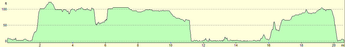
| Distance | 20.8 miles |
| Description | This was a surprisingly pleasant walk, from Ipswich to the start of, then along, the Sandlings Way. |
| Pack | Today I carried my 30-litre Karrimor rucksack, filled with water, my waterproofs, a couple of books and other odds and ends. |
| Condition | I feel absolutely fine after this walk, and could easily have walked further if necessary. |
| Weather | The day was bright and sunny, with not much cloud in the sky. It was warm for the time of year, with a slight breeze to help me cool down. |
| OS map | Landranger number 169 (Ipswich & The Naze, Clacton-on-sea) and Landranger number 156 (Saxmundham, Aldeburgh & Southwold) |
 |
 |
|
Map of the walk
Maps courtesy of Google Maps. Route for indicative purposes only, and may have been plotted after the walk. Please let me have comments on what you think of this new format. For a detailed table of timings for this walk, please see the table file.
 |
 |
|
Notes
Before we moved back up to Cambridge, I looked around at some of the walks that I could do in the area. I had walked hundreds of miles in Cambridgeshire during my previous stints of living in the county, and so it was a case of finding ones slightly further abroad. Someone on my blog suggested the Sandlings Walk, which heads northeastwards through Suffolk from near Ipswich. Since I wanted to do a car-camp to test my kit for the new season, the Sandlings Way felt like a good choice. The first problem was that my OS maps did not show the trail, which has only recently been designated. I therefore had to spend a pleasant hour marking the trail out onto the maps.
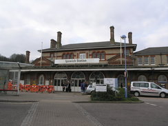
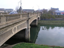
I found a cheap car park about half a mile from Ipswich railway station - an old shopping centre that had closed, but the car park was open. This seemed like a great idea - a way of reducing parking congestion and getting some income for the owners of the premises. It took me a few minutes to get my kit together and ensure that all my camping gear was out of sight, then started walking. Ipswich was hardly a new town to me, but it seemed to have been improved since my last visit. Smart new shops and flats lined the road until I reached an old level crossing over the road, now blocked off by palisade railings. This used to lead to the docks; the bridgethat carried the line over the Orwell was a short distance away. Sadly the palisade fence shows that the line is not long for this world.
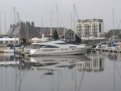
After nipping into Ipswich station, I crossed the river and started walking just south of the centre of town. On the way I passed two churches close to each other, towering above which was the hollow shell of a concrete building. This led me to the docks area, which was impressive. The docks were filled with yachts and boats, and some old buildings had been sensitively restored and converted. This website details some of the work done during the developments. It was a really pleasant area to be out and about on a morning stroll.
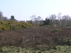
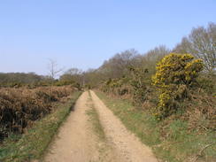
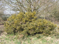
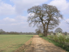
A road took me uphill out of the city, and the stream of traffic queuing to enter included an MG T, looking a little out of place amongst the larger vehicles. I put my head down and strolled on along the road, which was the only boring walking of the day. After passing a roundabout I reached a church, after which was the start of the Sandlings Way. The first part of the path was fairly inauspicious as it squeezed between some houses and a hall, and then between fences. I started to wonder what this diversion away from the road could possibly offer, when it emerged from between the fences and onto a small area of superb heathland. The contrast was breathtaking, especially in the sunshine. With a literal spring in my step I headed across the heath before, sadly, the path diverted back to the road.
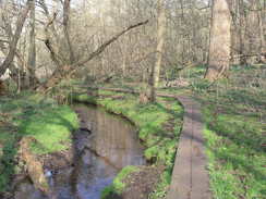
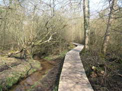
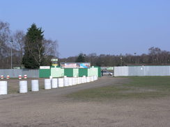
Fortunately the trail did not stay with the road for long, and soon diverted off along a rough track between houses. It passed through another area of heathland, before passing across fields. The next stretch of path was perhaps the highlight of the day; a long stroll along a boardwalk, with a perfectly clear stream off to the left. Much of the boardwalk appeared new - perhaps a replacement as old timbers were piled beside the path. It was surprising to see that such a wonderful walk could exist in what had felt like a built-up area. Eventually the trail climbed up away from the stream and approached the slightly ramshackle Foxhall Stadium, a stock-car racing venue. It seemed quiet enough as I strolled past, although it must be very noisy once the racing starts.
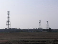
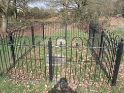
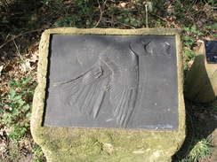
Three large steel structures appeared ahead, looking like malformed electricity pylons. These turned out to be the remnants of the Foxhall Heath transmitter station, the shape and style of the masts belying their age. My 1:25,000 OS map showed open fields across the Long Strops, but a long group of new-build houses had been built off to the left. The different styles and fashions of these seemed to complement the path despite the intrusion. Some railings enclosed a small area near a road - this is Dobbs Grave, the grave of a sherpherd who hung himself rather than face transportation for losing a sheep. A sad story, but it was good to see that the grave was both marked and cared for.
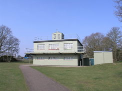
A little further on came a surprise - what was obviously an old airfield control tower, but in a built-up area. A noticeboard said that this was the control tower of RAF Martlesham Heath airfield, which has now mostly been built over. The control tower itself is the headquarters of the Martlesham Heath Aviation Society.
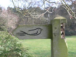
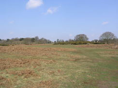
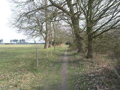
Part of the old airfield site is now the headquarters of the Suffolk Constabulary, and a dog handler was exercising his dog nearby as I strolled past. After crossing under a dual carriageway, the path skirted a large Tesco superstore before entering more open land. A sculpture here marked the Sandlings Walk, one of a series that are apparently scattered along the trail. A long and easy-to-follow trail passed right through the middle of some woodland, before leading past Martlesham Hall and descending down to meet the southern bank of Martlesham Creek.
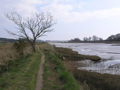
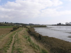
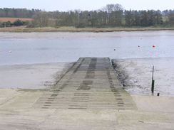
I had walked along or around the creek previously, and it felt good to be back on known territory. A bank took me across the head of the creek, and then I discovered a sign stating that the path that followed the bank along the northern edge of the creek was closed due to works. Since the marked diversion was overly long, I decided to risk it and press on. It was a lovely stretch of path, and although the ground underfoot was rough in places there was no sign of any works. In the end I reached Kyson Point and could join the foreshore.
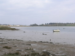
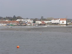
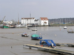
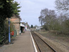
The walk from the point up to Woodbridge is always worth doing, and doubly so in the sunshine. The only downside was that the tide was out, meaning that the River Deben was flanked with mud rather than gleaming waters. People were scattered about, all seemingly enjoying the unseasonal sunshine and warmth, and I was surprised to see that no-one was eating ice creams. By this stage I had walked quite a distance and I was in need of a break. At Woodbridge station I diverted inland and found The Anchor. This was busy, but I found a spare table and sat down. Someone was eating a meal, and the glorious smells wafting over convinced me to order some myself. I sat down and my sausage and mash arrived (and departed) quickly.
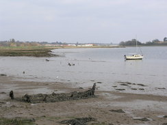
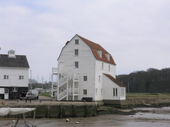
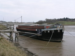
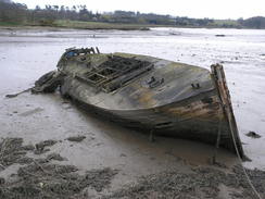
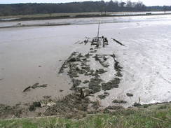
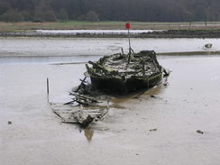
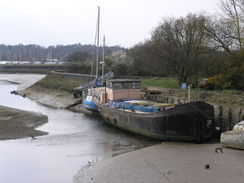
Back on the trail, I headed towards the wonderful eighteenth-century tide mill, whose shock-white building sits well on the waterfront. Despite having walked here a dozen times before, I walked the wrong way and had to backtrack to find the path that led onto the flood bank. This took me along the western bank of the river, which was filled with moored boats and not a few hulks in various states of decay. One of these had rotted almost completely down to the mud, its presence marked by a yellow buoy.
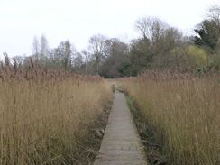
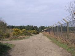
The banking took me to Wildford Bridge, which took me across the river. Another wooden causey took me through a wonderful reed-filled area before dropping me unceremoniously onto a road. This was followed all the way through the hamlet of Bromeswell, before thankfully heading off along another track. This freedom was soon spoilt by a golf course that had to be carefully negotiated, before the trail started to flirt with the western edge of Rendlesham Forest. This led me to the western boundary fence of RAF Woodham, which is still in use by helicopters.
I had a choice at the main road; I felt fit enough to extend the walk further, but I knew a train was due in forty minutes. The next train after that was not for an hour and a half, so I wimped out and decided to catch the earlier train. The walk proved to be easy to walk despite the traffic and I made good time, although I was shown up by a woman in fatigues who jogged past. The road passed the entrance to Sutton Hoo, before descending down to Wilford Bridge once more. Melton station was a short distance away, and I arrived with five minutes to spare. It had been a surprisingly good day's walk, and I was looking forward to the next day's stroll.
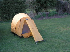
First, though, I had to find the campsite. This was at Run Cottage, just outside the village of Hollesley. It was past six by the time I had caught the train back to Ipswich, walked to my car and driven to the site, so I hurriedly erected my tent in the well-kept grass and quickly cooked some food. The skies were clear and it was going to be a cold night, so with the last of the daylight I strolled up to the village pub for a celebratory drink.
 |
 |
|
Directions
This walk starts at a temporary car park off Ranelagh Road in Ipswich at TM150441; dimply follow Ranelagh Road east-southeastwards for half a mile until Ipswich railway station is reached, which may mark a better place to start the walk. Leave the station and carefully cross Ranelagh Road to reach the Princes Street bridge over the River Orwell. On the other side of the bridge, turn right to follow the A137 Commercial Road eastwards. As this curves to the left, turn right to continue eastwards along the A137 Grafton Way until a roundabout is reached, with a bridge over the river on the right.
Turn left at the first roundabout to head north for a short distance, and then turn right at a second roundabout to head eastwards down the A1022 Star Lane. This passes two churches on the right; after the second turn right down a short road to reach Key Street. Turn left to walk eastwards along this road, before turning right to access the quayside. Turn left to head eastwards along the quayside, and after University Campus Suffolk is passed on the left, turn left up Coprolite Street. This soon ends at the B1458 Duke Street; turn left along this to reach a roundabout, and then turn right to join the A1156 Fore Hamlet
Follow this road eastwards as it heads east-southeastwards for 1.6 miles until it reaches a roundabout with the A1189 at TM194430. Carefully cross the roundabout to access Bucklesham Road; a pedestrian crossing to help you cross the A1156 is a short distance away on the right. Continue eastwards down Bucklesham road, immediately passing a church on the right. After a few yards a narrow pathis reached on the left, which runs with a fence, driveway and church hall on the left. This marks the start of the Sandlings Walk, which will be followed for most of the rest of the day.
Follow the path as it heads northeastwards; after a short distance it curves sharply to the right to run between fences. The path curves to the left before emerging out onto some heathland; immediately turn to the right to access a wider path. Turn left and follow this path eastwards across the hillside; eventually the path becomes less open. Take a track that leads off to the right, crossing a stream on a bridge before ending back at Bucklesham Road (do not enter the golf course).
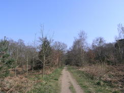
Turn left and follow Bucklesham Road east-southeastwards for a third of a mile until a track leads off to the left, towards Ipswich Golf Club. Follow this for a few yards, and then turn right to join a rutted track called Purdis Farm Lane. Follow the lane for nearly a mile, passing Purdis Hall and Farm on the left. Shortly after it climbs up a small hill, a junction with a path is reached on the left at TM219428. Turn left and follow this footpath as it skirts the side of a field, before entering an area of woodland and descending downhill.
The path crosses a bridge over a stream, and then turns to the left to keep the stream on the left. Much of the following stretch follows a boardwalk, which makes the going easier of boggy ground. When a junction with another boardwalk is reached, turn right to climb uphill; the boadwalk soon ends, and the path reaches Foxhall Road at TM212439. Turn right to follow this road uphill for a few yards, and then turn left along a footpath that passes a house on the left before quickly ending at a track. Follow this track northwards as it heads towards the Foxhall Stadium.
As the track approaches the stadium, it curves around to the right across some grass, taking a more east-northeasterly course as it enters an area of woodland before reaching Bell Lane at TM218445. Turn left to head north along this lane for a few yards, and then turn right to take a bridleway that enters a car park. Continue on eastwards, keeping a hedge to the right. Eventually the broad track widens out into playing fields; when the fields end at woods, turn left for a few yards and then right, to join a track that runs northeastwards through the woods, emerging out onto a road at Dobb's Corner (TM238452).
Cross the road and take a track that heads straight on the other side; when it meets another track, turn left to head north along this track with a playing field on the right. When this reaches a school at TM238455, turn right along another track. Just before this reaches an old aircraft control tower, turn left along a path that runs along an old concrete airfield parameter track. This curves to the right, passing the Suffolk police headquarters before approaching a dual carriageway. When it meets Portal Avenue, turn right to follow the road with the dual carriageway to the left, before descending to reach a subway.
Turn left to pass under the dual carriageway, and on the other side continue straight on northeastwards across some heathland, with the car park belonging to a large Tesco Extra superstore a short distance away to the right. Shortly after the northwestern corner of the car park is passed, turn right along another path to head eastwards across heathland. Keep another, smaller, car park on the right, before the path ends at Felixstowe Road at TM249461.
Carefully cross the road and enter a car park on the other side. Continue straight on and go through a gate to join a track that runs eastwards for two-thirds of a mile through the centre of some woodland, eventually emerging out onto Newbourn Road. Head straight on eastwards along this road for a couple of hundred yards, and as it curves to the right turn left to join another footpath. This heads northwards across a field before ending at Waldringfield Road at TM261463.
Turn right along this road for a few yards and then turn left along a track that heads northwards. This slowly curves to the right and descends to reach Martlesham Hall. Pass the buildings for a few yards, then turn left to take a footpath that heads uphill along the edge of a field, with a hedge on the right. Follow the footpath as it heads through a church car park. It then turns to the left, again with a hedge on the right. When the hedge ends, turn right to cross a lane and go through another hedge to join another footpath. Follow this downhill through Sluice Wood to reach the southwestern bank of Martlesham Creek at TM258470.
Continue straight on northwards, with the creek to the right. When the northwestern corner of the creek is reached, turn right and follow a rather ramshackle floodbank eastwards for three-quarters of a mile. The path drops down onto the foreshore as it approaches Kyson Point. Note: at high tides this part of the path may be impassable. Follow the path around as it curves to the left to head northwards along the foreshore. After a short distance it climbs up the small hillside to the left; when it meets a track turn right to descend down to join another stretch of floodbank. Head along the floodbank as it winds north-northeastwards, eventually becoming a promenade before reaching Woodbridge railway station.
Pass the station and continue on until a level crossing is reached on the left. Turn right to follow the promenade around past a quayside. When a road is reached near to the tide mill, turn left towards the level crossing, and before it is reached turn right along a footpath with a railway line on the left. The path eventually merges with the floodbank, and this can be followed curving around north-northeastwards for 1.3 miles until Wilford Bridge is reached at TM291501.
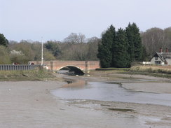
Turn right to cross the bridge, and on the other side turn left to descend down to a footpath that runs on a causey through reed beds. It emerges out from the beds to meet Common Lane at TM294501. Turn left and follow this road as it heads northeastwards, curving around into Bromeswell. As the road curves to the left, turn right and follow the road southwards until the A1152 road is reached. Turn left along this road, and after a few yards turn right along a track that starts to ascend. As the track starts to curve to the left, turn right to head straight on along a footpath that crosses a golf course.
Just before a building called Lion's Den is reached, turn left along a bridleway that heads east-southeastwards, eventually leaving the golf course and running with trees on the right. When a T-junction with another track is reached at TM313493, turn right and follow this new track southwards for two-thirds of a mile. The westernmost fence of RAF Woodbridge is followed on the left before the trail reaches a road at TM310483.
Here this walk leaves the Sandlings Way. Turn right and follow the road northwestwards for a mile, until a junction is reached with the B1083 road. Turn right and follow this road north-northwestwards as it descends downhill to reach a roundabout after 0.7 miles. Turn left here, to continue along the A1152 as it crosses Wilford Bridge; Melton station is a quarter of a mile away on the left.
 |
 |
|
Distances
| From | To | Distance (m) | Ascent (ft) | Descent (ft) |
|---|---|---|---|---|
| Ipswich car park | Start of Sandlings Walk | 3.4 | 148 | 62 |
| Start of Sandlings Walk | Martlesham Heath | 5.3 | 141 | 138 |
| Martlesham Heath | Woodbridge | 4.8 | 89 | 177 |
| Woodbridge | Sutton Heath | 5.1 | 197 | 121 |
| Sutton Heath | Melton station | 2.2 | 43 | 125 |
This makes a total distance of 20.8 miles, with 618 feet of ascent and 623 feet of descent.
For more information on profiles, ascents and descents, see this page
Accommodation
I spent the night at Run Cottage, which is situated just outside the village of Hollesley. It cost me just £10 for a ptich for the night, and the facilities were all clean and tidy.
Transport
Regular train services run between Melton and Ipswich stations, calling at Woodbridge station on the way.
 |
 |
|
 |
 |
|
 |
 |
|
 |
 |
|
 |
 |
|
 |
 |
|
 |
 |
|
 |
 |
|
 |
 |
|
 |
 |
|
 |
 |
|
 |
 |
|
 |
 |
|
 |
 |
|
 |
Disclaimer
Please note that I take no responsibility for anything that may happen when following these directions. If you intend to follow this route, then please use the relevant maps and check the route out before you go out. As always when walking, use common sense and you should be fine.
If you find any information on any of these routes that is inaccurate, or you wish to add anything, then please email me.
All images on this site are © of the author. Any reproduction, retransmissions, or republication of all or part of any document found on this site is expressly prohibited, unless the author has explicitly granted its prior written consent to so reproduce, retransmit, or republish the material. All other rights reserved.
Although this site includes links providing convenient direct access to other Internet sites, I do not endorse, approve, certify or make warranties or representations as to the accuracy of the information on these sites.
And finally, enjoy your walking!
Nearby walks
| # | Title | Walk length (miles) |
|---|---|---|
| 107 | Stowmarket to Ipswich | 16.1 |
| 131 | Ipswich to Wickham Market Station | 16.7 |
| 132 | Wickham Market Station to Darsham Station | 12.7 |
|
|

|