Walk #878: West Cowes to Ryde via Newport
 |
 |
|
General Data
| Date Walked | 04/01/2011 |
| County | Isle of Wight |
| Start Location | West Cowes ferry landing |
| End Location | Ryde |
| Start time | 08.16 |
| End time | 14.36 |
| Distance | 17.6 miles |
| Description | This was a varies walk, initially following an old railway line up to Newport before returning along the other side of the river. The Isle of Wight Coastal Path is then joined, although the sea is not visible for most of that particular stretch. |
| Pack | Today I carried my 30-litre Karrimor rucksack, filled with water, my waterproofs, a couple of books and other odds and ends. |
| Condition | I feel absolutely fine after this walk. |
| Weather | Today was a grey and fairly cold day. There was not much, if any, sign of the sun, and as can be expected from early January it was bitterly cold early on. |
| OS map | Landranger number 196 (The Solent & The Isle of Wight, Southampton & Portsmouth) |
 |
 |
|
Map of the walk
Maps courtesy of Google Maps. Route for indicative purposes only, and may have been plotted after the walk. Please let me have comments on what you think of this new format. For a detailed table of timings for this walk, please see the table file.
 |
 |
|
Notes
It is possible that we will not be in the Southampton area for much longer, and therefore I am turning my attention to some walks in this area that I have yet to do. Strangely, despite being on the south coast for three years, I have yet to do any walks on the Isle of Wight. Therefore Sencan drove me down to Southampton early this morning, and I bought a ticket for the Red Jet ferry to West Cowes. Unfortunately the VAT rise had occurred overnight, and therefore the ticket cost me a few more pence than it should have done.
A crowd slowly grew as I waited or the ferry, but I chose not to queue and instead looked out over Southampton Water. At least one cruise liner was visible in the distance, its lights reflecting across the darkened water. Before long I was on the ferry and received a distinct kick in the back as it set off. It should be made clear; this ferry is fast; my GPS recorded a max speed of 45 MPH (about 40 knots). A solar eclipse was due at dawn, but the sky overhead was mostly cloudy and the ferry's windows were wreathed with condensation.
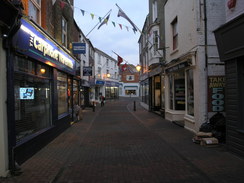
The ferry docked at West Cowes early and I walked up the pontoon to take my first steps on the Isle of Wight. West Cowes seemed a pleasant enough place, and it was obviously dominated by sailing - many shops were firms offering sailing training or services. Unfortunately the waste management services were in not as good a shape, as it was clear that the rubbish had not been collected for some time; many houses had over ten bags of rubbish outside.
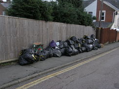
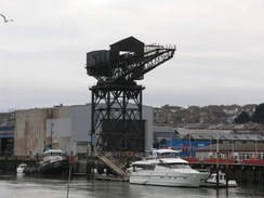
Most walkers would choose to take the 'floating bridge' ferry across the River Medina to East Cowes, but my coastal walks are dominated by a requirement not to take ferries. This meant a long walk north alongside the Medina to Newport, and then back down the other side. Fortunately this eastern side of the river has a good path alongside it, part of the old Cowes and Newport railway line that opened in 1862 and closed a little over a hundred years later in 1966. I had to reach this, however, and this meant a long walk along litterbag-strewn suburban streets. A gigantic shipyard crane loomed overhead for some of this walk, the 1911-built Giant Cantilever Crane, which reminded me of some I had seen beside the Clyde in Glasgow.
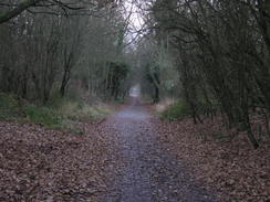
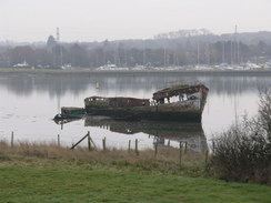
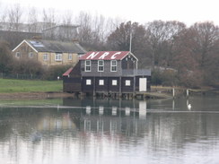
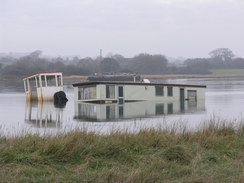
The railway path started in a rather inauspicious industrial estate, but the buildings were soon left behind. It was an enjoyable stroll, but the Medina was only occasionally visible through the trees to the left. The number of dog walkers, cyclists and joggers decreased as I headed away from Cowes, and soon I was walking on my own. In a couple of places inlets took the water up to the path; a wooden hulk was slowly rotting away in one of these.
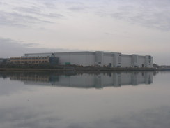
Soon a large building loomed up ahead. Its scale seemed enormous, far too large for such a rural location. Activity showed that it was still under construction, although substantially complete, and a security guard kindly told me what it was: a building for Vestas, the wind turbine manufacturer. This surprised me as the company had been in the news for closing their factory on the Isle of Wight. It turns out that they did close the factory, but this is a new research and development facility.
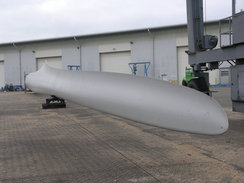
A little further on was the old factory, and fortunately there was a turbine blade sitting outside where it would be photographed. The scale of the blade was enormous, making me realise quite how large the final structures would be. Twin arms of a curving loading dock jutted out into the river, allowing, I guessed, the finished turbines to be sent out on barges. It felt as though the new R&D building was far bigger than this old factory, yet would employ far less people.
The railway path soon ended and I was strolling through another industrial estate on the outskirts of Newport. The first road bridge over the year proved slightly difficult to negotiate as there was no footpath, and no path down to the riverbank on the other side. After a slight diversion I found myself by the river once more and I started heading north.
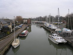
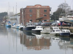
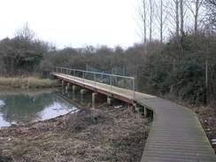
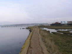
The map showed a footpath following the eastern bank of the Medina for the first few miles. Initially I headed through another semi-industrial area, complete with bus and boat museums. Soon this was left behind, and a path headed alongside the riverbank, on a couple of occasions crossing inlets on long footbridges. The views over the Medina were far better from this bank than they had been from the railway path on the other side and it made for an enjoyable stroll; it was only a shame that the sky was overcast.
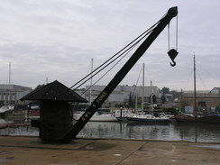
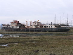
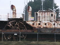
Soon the vast bulk of the new Vestas building became visible across the water, and soon after this I encountered another surprise; an old paddle steamer, the SS Ryde, stuck in the mud beside a marina. This was in a real state, and it is no surprise that attempts to preserve and repair the large ship are failing. It was a sad sight to see such a glorious ship in a state of advanced decay. A small tugboat sat on the quayside by Ryde's bow, and nearby was a large circular building; a tower controlling access into the large marina.
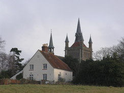
The lock gates were open, preventing me from accessing the footpath on the other side. As I approached the lock a mechanical noise started and the gates started to close, I strode across, waved at the control tower and headed off. Boggy stretches of mud continued on the path to the north of the marina, and I eventually took a wider path slightly inland of the coast to avoid the worst mud, something others had evidently done. It was a relief when a pub was reached, meaning that the vlayye floor would be left behind. Another path and roads took me from here to West Cowes, passing close to the glorious Whippingham church, which looked far too grand for such a rural location.
A new housing estate, unmarked on my OS map, stretched between West Cowes and the church. The houses all appeared to be well built, and many were painted in the pastel shades so beloved by some seaside villages. Many houses were evidently occupied, whilst more were being built a short distance away. They all appeared to be of high quality and were in direct contrast to those that followed; streets of older housing stock that were showing their age. The uncollected rubbish also resumed, with streets bedecked, not with post-Christmas holly but with stinking black bags.
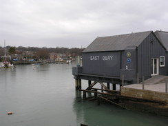
The lifeboat station in West Cowes was situated in a strange place; by the road beside a marina, seemingly some way inland from the water's edge. A little further on a massive industrial building spanned the gap between the river and road; a sneaky glance in through the window showed a sign saying 'A380 fabrication bay'; surprisingly, parts for the massive Airbus superjumbo are manufactured on the island.
I soon reached the centre of East Cowes, and I walked past the shops to the ferry terminal, where the car ferries from Southampton dock. Nearby was a brand-new Waitrose, but instead I headed into the adjacent Co-op to buy a few snacks. From now on I would be following the Isle of Wight coastal path, but unfortunately it looked as though the first few miles would be along roads, some way inland from the coast.
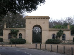
The road took me uphill, curving past the entrance gates leading to Osborne House, Queen Victoria's holiday house on the island. Another works was passed, again making aeroplane components, before Whippingham was entered. It was a relief when the main road was left behind and a minor road took me eastwards towards Wooton. There was not much traffic on the road, but there was also not much to see; I only saw one glance of the sea, and that was a long way away at the end of a valley. To make matters worse, it started to spit with rain.
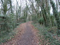
The path through Wooton was difficult to follow as it headed towards a bridge over Wooton Creek; it followed residential roads for a short distance before diverting along paths. Eventually I found the correct path and reached the creek. I resisted the temptation to head into the pub, and instead followed the road uphill until a path led off towards Fishbourne. Again there were no views of the creek or the sea, but at least the wooded path was pleasant until it ended at a road.
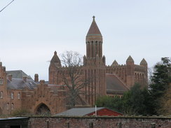
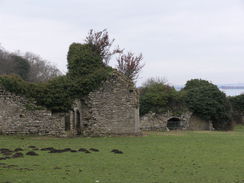
It started to rain harder as I passed the car ferry terminal at Fishbourne. I stopped to put my coat on and immediately felt better. A track took me eastwards, and again the lack of views of the sea on this coastal path proved annoying. Fortunately something soon attracted my attention; a massive building down in a dip to my left. This was Quarr Abbey, a monastery refounded in 1907. A short distance away were the ruins of the original Cistercian abbey, much of which had been rebuilt into a house and abbey. I felt unaccustomed pangs of jealousy towards whoever lived in such a historic place.
I was starting to feel fatigued by now; there had been far too many miles along tarmac during the day and my feet were aching. As often happens in such cases my aching feet caused me to take an unusual gait that made my legs feel tired. I knew that a short stop would ease these problems, but Ryde was now only a mile or so away. I passed a woman as I was heading down the road into the town, and we started chatting as we walked. She was a local woman who walked the mile to and from work every day, and she was surprised to find that anyone was walking the coastal path, especially in winter!
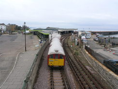
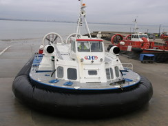
Ryde is dominated by the pier that stretches out to sea; the second longest in the UK. It is actually two piers, one carrying vehicles and the other trains, with the remains of a third (which used to carry an old tramline) trapped in between them. I felt like I could walk on further but was unsure of the situation with transport back to Cowes from further along the coast. Instead I climbed onto the footbridge over the railway line and watched as a hovercraft set off for the journey back to Portsmouth, a journey that I hope to take soon.
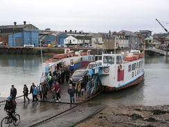
The bus dropped me off by the Waitrose in East Cowes, and I had to get across the Medina to reach the Red Jet terminal in West Cowes. Fortunately there is a ferry that regularly runs across the river between the two halves of the town, and I strode to the jetty expecting to find a small boat. Instead I was greeted with the sight of the Cowes floating bridge, a large chain ferry capable of taking cars across the river. It was an ugly ferry, with none of the minimal grace of, for instance, the Sandbanks ferry; advertising clad its sides, but somehow it felt of its place, with the crane looming overhead.
I sped through West Cowes, but I reached the jetty just as a ferry was leaving. There was half an hour before the next ferry, so I had time to reflect on what had been an enjoyable day's walk. I think that it hardly showed the best of the Isle of Wight, though; that is yet to come.
 |
 |
|
Directions
This walk starts off at the Red Jet ferry terminal in West Cowes on the Isle of Wight. Walk up the jetty and head past the ferry foyer to reach a road; head along this for a few yards and head under an archway to reach the High Street. Turn left and follow the High Street southwards; it winds around and climbs uphill before ending at the A3020 Medina Road. Turn right along this for a few yards and then turn left to head south down York Street. After a few yards this ends; cross another road and continue on along Pelham Road. Take the first road off to the right, South Road, which heads uphill for about fifty yards, and then turn left along Arctic Road. Continue southwards along Arctic Road as it enters an industrial estate; follow the road as it curves to the right and then turn immediately to the left to join the old railway line, which is now a cycle path.
Follow the cycle path southwards for three miles as it roughly follows the western bank of the River Medina until it ends at a road in an industrial estate at SZ500901. Join this road and follow it southwards; pass a large roundabout and continue as the road swings to the left. As it approaches the bridge carrying the A3054 road over the river turn left up a sliproad and turn left to reach the bridge over the river. There is no pavement across the river bridge, but the verge is wide enough.
A steep bank leads down to the left on the eastern side of the river; this is too steep to climb down, so continue on as the road passes over a pedestrian underpass, and then head down a path to the left that leads to a car park and then the riverside. Turn right and follow a road, Sea Close, alongside the river. Follow this as it passes a bus and then a boat museum before approaching a hotel and pub. The path heads inland of the pub and enters some parkland. The path crosses the park parallel to the sea; when a hedge is reached turn left to reach the shore, and then turn right along the path.
The path follows the shoreline as it winds southwards, sometimes crossing creeks on footbridges. It is clear and easy to follow, if boggy in places; 1.3 miles after the pub a marina is reached at SZ509919. The mouth to the marina is crossed using the lock gates; you may have to wait for them to close to cross. The gates are guarded by red lights that proved hard to see as they were so low down.
Cross the lock gates and then continue on northwards along the bank of the river; it soon heads a few yards away from the foreshore to bypass the boggiest stretches. After half a mile a tidal creek is crossed via a footbridge; the path climbs up a bank on the other side and continues above the river for a few hundred yards until the Folly Inn is reached.
Here the riverbank is left behind. Follow the access road to the inn uphill eastwards, with a fence on the left; when the road curves to the right turn left along a footpath. Initially this passes a caravan park on the right before entering a field. Keep a fence close-by on the left across the field as the path descends into a wooded area. The fence is left behind as the path crosses a stream on a plank bridge and climbs up the other side to leave the woodland and enter another field.
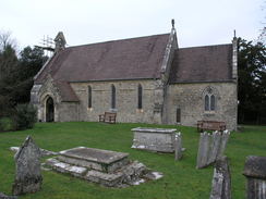
Turn half-right across the field, passing under some power lines to reach a stile. Cross this and head northwards across the next field, aiming just to the left of Whippingham church. Cross a stile in the corner of the field and then follow a path with a graveyard on the right. This path ends at a road at SZ511936. Turn left and follow a good path that parallels the road northwards past a new housing estate.
A couple of roads need to be crossed; the path ended opposite a school, so I had to cross the road to gain access to the pavement on the other side. It looks likely that the traffic-free path will be extended further when new houses are completed. Continue north along this road as it enters an older housing estate and descends to end at a junction with the B3321 at SZ507948.
Turn left and follow the B3321 downhill to the west for a few hundred yards; it curves to the right. Turn left down Minerva Road a few yards past the bend and follow this as it descends and curves around to the right, becoming Clarence Road as it passes the walls of a large industrial complex on the left. When Clarence Road ends at a T-junction with the A3021 at SZ502955, turn left and follow the road the short distance to the floating bridge. This marks the start of the Isle of Wight coastal path, although the first few hundred yards of the walk noted below vary from the official route.
Turn right and follow the road north towards the vehicle ferry; at a roundabout turn right along Well Road and follow this southeastwards, passing a Waitrose store on the way. Follow the road as it heads uphill, curving to the right near a church and then to the left once more. Continue along this road for 1.7 miles as it climbs uphill and curves around, passing the entrance to Osborne House and a roundabout (not marked on old OS maps) on the way. There is a pavement the entire time, although it is occasionally necessary to cross the road as the pavement swaps from one side to the other.
When a road junction is at SZ516933 turn left down Alverstone Road. Follow this road east-southeastwards for 1.5 miles until it ends at a road junction with Palmers Road at SZ537924. Turn left along Palmers Road for a few yards, and then turn right to head eastwards along Footways for a fifth of a mile until it ends at a T-junction. Turn left for a couple of yards, and then turn right down a footpath that initially heads down a driveway before squeezing past fences.
This footpath soon ends beside some garages; turn left down the access road to reach St Edmund's Walk. Turn right to head downhill along this road for about a hundred yards. Just after Whitehead Crescent comes in on the left (and before the road curves to the left), turn right past some garages. This leads to another path on the left, which can be followed downhill between fences. It becomes School Lane, which then ends at a T-junction with New Road. Turn right to head south along New Road, but before the main road is reached turn left along a footpath that soon ends at the Sloopm Inn on the (inaccurately-named) Mill Square beside Wooton Bridge.
Cross the bridge and continue uphill along the A3054 road. After a third of a mile, at SZ551921, turn left along another footpath. This heads north and then north-northeast for a third of a mile. At SZ553926 turn right along another footpath that brings you out onto the B3331 road. Turn left and follow this road as it heads northeastwards for a quarter of a mile, passing the entrance to Fishbourne ferry terminal on the way.
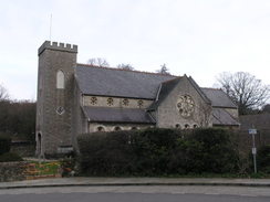
When the Fishbourne Inn is reached at SZ557928 turn right along a lane called Quarr Road. This heads in a rough easterly direction for a little over a mile. Quarr Road is left at SZ570925 as a path leads off to the left, joining a driveway beside some gates to reach a road in Binstead at SZ574927. Turn left along this road and follow it as it immediately swings to the right to meet another road. Turn left along this road and follow it northwards for about fifty yards to Binstead Church. The road curves to the right beside the church to head eastwards; as the road curves to the left continue straight on along another path.
Follow this surfaced path eastwards as it descends down to a stream, with Ryde Golf Course on either side. It curves to the right slightly to head east-southeastwards; half a mile after the church it goes through some gates and reaches a complex road junction beside the A3054. Do not head towards the A3054, but instead turn half-left down a track called Spencer Road. This heads northeastwards downhill before curving to take a more easterly course. Continue along Spencer Road until it ends at a T-junction with St Thomas's Road at SZ590927 (1). Turn left and follow St Thomas's Road as it heads downhill and curves to the right to head northeastwards. Join the esplanade through Ryde; the bus and railway stations are a few yards away on the left.
(1) The map and some guides have the coast path turning left from Spencer Road down Buckingham Road from SZ590926; this road then curves around to reach St Thomas's Road slightly downhill from the route described above. The signs on the ground follow the route described above. There is little difference in either route.
 |
 |
|
Distances
| From | To | Distance (m) | Ascent (ft) | Descent (ft) |
|---|---|---|---|---|
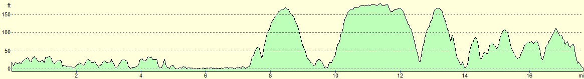
| West Cowes | Newport | 4.7 | 259 | 253 |
| Newport | East Cowes | 5.0 | 289 | 308 |
| East Cowes | Ryde | 7.9 | 741 | 741 |
This makes a total distance of 17.6 miles, with 1289 feet of ascent and 1302 feet of descent.
For more information on profiles, ascents and descents, see this page
Transport
There are a couple of wys to get back from Ryde to West Cowes; the route I took was by taking the hourly Southern Vectis route 4 from Ryde to East Cowes, and then catching the floating bridge across the river and walking to the ferry terminal in West Cowes.
Alternatively, route 9 operates every ten minutes during the day from Ryde to Newport, and then the very frequent route 1 runs from Newport back to the ferry terminal in West Cowes.
 |
 |
|
 |
 |
|
 |
 |
|
 |
 |
|
 |
 |
|
 |
 |
|
 |
 |
|
 |
 |
|
 |
 |
|
 |
Disclaimer
Please note that I take no responsibility for anything that may happen when following these directions. If you intend to follow this route, then please use the relevant maps and check the route out before you go out. As always when walking, use common sense and you should be fine.
If you find any information on any of these routes that is inaccurate, or you wish to add anything, then please email me.
All images on this site are © of the author. Any reproduction, retransmissions, or republication of all or part of any document found on this site is expressly prohibited, unless the author has explicitly granted its prior written consent to so reproduce, retransmit, or republish the material. All other rights reserved.
Although this site includes links providing convenient direct access to other Internet sites, I do not endorse, approve, certify or make warranties or representations as to the accuracy of the information on these sites.
And finally, enjoy your walking!
Nearby walks
| # | Title | Walk length (miles) |
|---|---|---|
| 304 | Langstone to Tipner | 16.8 |
| 305 | Tipner to Browndown | 18.9 |
| 306 | Browndown to Bursledon | 12.9 |
|
|

|