Walk #877: A stroll around Christchurch Harbour
 |
 |
|
General Data
| Date Walked | 02/01/2011 |
| County | Dorset |
| Start Location | Hengistbury Head |
| End Location | Hengistbury Head |
| Start time | 09.55 |
| End time | 14.50 |
| Distance | 13.0 miles |
| Description | This was a pleasantly short stroll around Christchurch Harbour, with a little diversion to Highcliffe Castle. |
| Pack | Today I carried my 30-litre Karrimor rucksack, filled with water, my waterproofs, a couple of books and other odds and ends. |
| Condition | I feel absolutely fine after this walk. |
| Weather | Today's weather was mainly cloudy, with only occasional glimpses of blue sky and none of the sun. It was rather mild compared to the recent cold weather. |
| OS map | Landranger number 195 (Bournemouth & Purbeck, Wimborne Minster & Ringwood) |
 |
 |
|
Map of the walk
Maps courtesy of Google Maps. Route for indicative purposes only, and may have been plotted after the walk. Please let me have comments on what you think of this new format. For a detailed table of timings for this walk, please see the table file.
 |
 |
|
Notes
Between 2004 and 2007 I managed to walk over 1,000 miles a year, a figure that I was quite proud of, especially as it had to be fitted between work, relationship and other life commitments and hobbies. In the last three years, however, I managed just 380, 330 and 580 miles, far below my expectations. This had been because of a combination of injuries and life getting in the way.
Therefore I felt like starting off 2011 with a good walk. The forecast for today looked good, but as I had no handy walks planned. A glance at my maps showed that there was a small gap on the eastern side of Christchurch Harbour that I had not walked since my coastwalk, so I set off to do a short walk around the harbour.
I parked at the Hengistbury Head car park, which fortunately only costs one pound for an entire day at this time of year. The forecast - which had been for sunshine - turned out to be less than accurate. Low clouds blocked most views of the sun, although a few scattered patches of blue sky could be seen. The only good thing that could be said was that it was far warmer than it had been recently - a barmy six degrees.
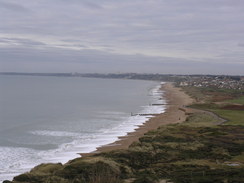
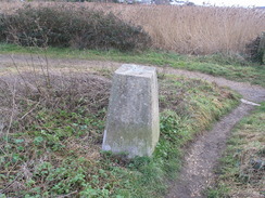
I warmed up on the initial walk up to the trig pillar at the summit of Hengistbury Head. The views were far better than they had been just a few weeks before - the Needles and the Isle of Wight were clearly visible instead of lying behind a grey haze. The view made me more determined to walk on the island soon, something I have been talking about doing for too long now.
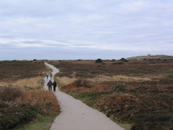
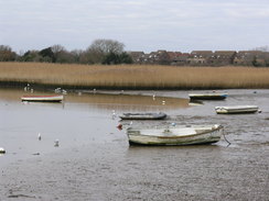
The path over the headland was bustling with Sunday morning joggers and dog-walkers who were taking advantage of the good weather. A lifeboat was playing about in the water below the headland, approaching and then moving away from a breakwater. I say playing as there did not seem to be any particular urgency about their movements. A descent led down to the sandy spit that strikes northwards from the headland, nearly blocking off the mouth of Christchurch Harbour. My plan was to take the ferry across the mouth of the harbour, but I had no idea if it was still running.
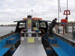
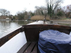
As I approached the jetty I saw the ferry just about to leave. I considered running to try and get it, but it was clearly too late. I watched as the ferry started motoring away, cursing my luck and not knowing how long it would be before the ferry returned. Instead of waiting I walked up towards the top of the spit, only to see the ferry motoring back. I jogged back to the jetty, reaching it just as the ferry was tying up.
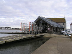
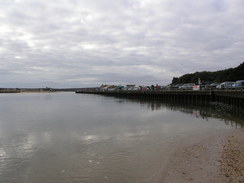
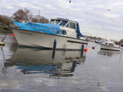
There is something good about being on a small ferry, sitting so close to the water that you could put your hand in if you wanted. The sunshine made it even more enjoyable, and as the boat tied up I found myself wishing that it had been a longer trip. Mudeford is a lovly little area, with lifeboat station, cafe and fish shop al squeezed onto the quay. A large cradle stood outside the lifeboat station, obviously belonging to the boat I had seen earlier.
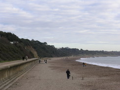
My plan to walk around Christchurch Harbour would have led to a short day, so instead I strode eastwards along the promenade to extend the walk. The sand had blown across the promenade in one place, making the going hard, but that was soon over. It was a really enjoyable stroll over ground that I had walked several times before, but the familiarity did not spoilt things. Soon the promenade ended and I followed a path of compacted sand immediately below the rising cliffs.
Sometimes whilst walking my mood can fall inexplicably; I feel low and depressed for no obvious reason, even on the sunniest of days in the most beautiful country. Likewise sometimes my mood can soar, again for no apparent reason. Today was one of these latter times, and I felt like singing as I strolled along. It was perhaps a good thing for the hearing of everyone around me that I did not.
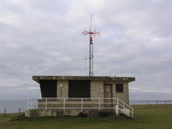
I was unsure how far I was going to walk along the coast before turning back, and when I reached Chewton Bunny (a little valley that runs into the sea from inland) I decided to climb up onto the top of the cliffs. Since I had walked along the foreshore on several occasions, it felt good to be high up on this stretch. The vast bulk of Hengistbury Head appeared almost like an island, with the harbour mouth in front and the beach leading towards Bournemouth invisible behind. Again I felt both literally and metaphorically high. Nearby were a series of concrete plinths, and a monument stood proudly on one of these; it turned out to be a memorial to an MOD complex on the site that once housed inflatable radar domes. These domes contained Britain's first satellite uplink station as part of the Signals Research and Development Establishment.
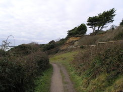
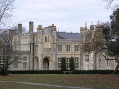
Unfortunately the cliff top path soon ended at housing, and I took a series of paths that rose and fell as it progressed westwards, sometimes near the top of the cliffs and at others near the bottom. It was a pleasant stroll despite the fact that the views were mostly obscured by vegetation, and I sped up as I ascended the zig-zag path that regained the top of the cliffs near to the impressive 19th Century Highcliffs Castle, which was just visible through a gap in the trees to the right.
From here it was a simple walk along the edge of the cliff through the Steamer Point Nature Reserve, heading though woodland before emerging out at the western end of the cliffs. After this I tried to keep as high as possible, following roads and paths slightly inland from the coast. When I reached Mudeford once again I nipped down to the very end of the beach to dip my boots into the sea; the sand proved to be exceptionally soft and so I made a hasty retreat. A fast current was flowing through the harbour mouth, and it seemed like a fairly dangerous place to contemplate a dip.
Mudeford Quay was bustling, not the least with children crab fishing. I did my usual thing of walking along and taking quick peeks into the buckets to see how many they had caught - one little girl had already caught eight or nine. I was tempted to nip into the cafe beside the pub to get a bite to eat, but it was busy inside and instead I walked on, starting the walk around Christchurch Harbour.
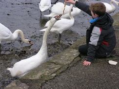
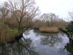
A little further on a boy was feeding swans with bacon, the swans craning their necks up to get at the food. After this more road walking took me onwards, passing Tutton's Well on the way. After this it was a case of taking a long, looping walk around Stanpit Marsh. I had last walked along here almost exactly eight years before on my coastal walk, and the path did not appear to have changed much. There was what I think was a new building beside the path; it was locked up, and I assume it was something to do with birdwatchers.
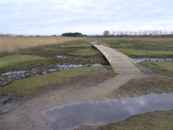
A little further on there was a bridge over an inlet; later I learnt from the excellent Hengistbury Head website that this was an early Bailey Bridge, and one of the few remaining extant examples of this type of bridge. The inlet that runs underneath was once used by smugglers to gain access to the nearby Ship in Distress public house.
Shortly after this the river was reached, and a footpath headed onwards across a series of plank bridges. I seem to recall that the path was far muddier when I walked along here previously and the bridges certainly looked newer. A little further on there was a rusting metal boat enclosed by a fence; the Hengistbury Head website says that this was an old lifeboat from a WWII Liberty ship. It was used locally before a storm threw it up to its final resting place.
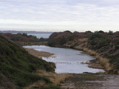
After this a path took me across a raised area of land, squeezing around a golf course. A preponderance of signs stated that this was an old tip that had been abandoned thirty years ago, and since then had been landscaped and converted to a golf course. This was a stretch of walk that I could not remember from my previous walk, and I wonder if I recorded my route correctly. Unfortunately the pleasant walk around the marshes had to end, and the path dropped me off into a car park and then onto a road in Christchurch.
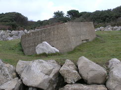
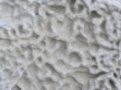
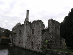
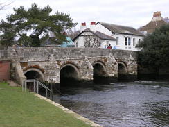
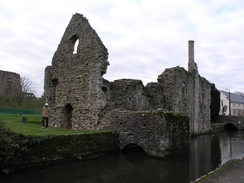
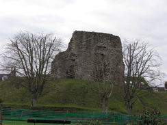
This part of Christchurch is particularly pleasant, and I stopped to take in the views from the bridges over two streams of the River Avon. Standing proud beside the second of these (the mill stream) was a ruined stone building - this is the Constable's House, originally built in about 1160. The ruins feature a cylindrical chimney, apparently one of only five Norman chimneys still extant in the UK. Visible behind the house were the ruins of the keep, standing proud on its keep. I wanted to go and have a look at these, but in the end I decided to visit these on another trip.
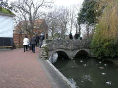
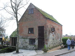
Instead, I headed down a good path that ran between the mill stream and the Constable's House. This passed right beneath the end wall of the magnificent Christchurch Priory, before curving to a small but perfectly-formed twin-arch bridge over the stream. Right next to this was Place Mill, which I was really taken by. It is an Anglo-Saxon watermill that remained in use until 1908, although I would think that it has been much altered over the years (for one thing bricks were not common until Elizabethan times). Perhaps it is a little like a broom that has had four new handles and five new heads.
Christchurch Quay was bustling and I hurried my way through, the crowds seeming oppressive. I stopped only to take a look at a little paddling pool for children that was strangely fascinating - an Archimedes screw took water to a channel which then deposited it onto an overshot waterwheel. Everything was switched off as it was the depths of winter, but it seemed like a great thing to entertain kids.
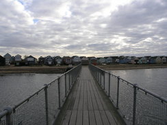
A little further on I noticed that the Wick ferry was on my side of the river. I had intended to walk the half-mile to the bridge over the Stour and then back down the other side, but it seemed like to good an opportunity to take two ferries in one walk. I strode down onto the jetty and boarded the small boat along with a man and his rather excitable dog. The ferryman was a jolly chap, but we did not have a chance to chat as after a couple of minutes he was mooring up on the western bank of the river.
The rest of the walk was one that I have done many times before, both on logged walks and at other times when I just want to go for a stroll. The path was easy to follow as it headed past the western side of Christchurch Harbour. Given the number of people in the town, it was surprising that the path was not too busy, and I idled along, wondering if I should try and extend the walk somehow.
The cafe beside the car park at Hengistbury Head was bustling, as should perhaps be expected on a sunny Sunday. Instead of extending the walk I headed to the car and got ready to set off back home, having completed an enjoyable stroll around the harbour. I can only hope that 2011 allows me many more walks like this one.
 |
 |
|
Directions
Before I give directions for this walk, it should be noted that it relies on two ferries. The Wick Ferry across the Stour in Christchurch can be avoided by a trip to the B3059 bridge upstream; this adds about a mile onto the route. The first ferry however, across the mouth of Christchurch Harbour to Mudeford Quay must be taken. Information on these two ferries can be found in the 'Transport' section below.
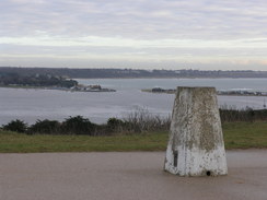
This walk starts off in the large car park for Hengistbury Head at SZ163910. Leave the car park by a gap in the bank in the southeastern corner and follow a path that leads to the top of the cliffs beside Double Dykes. Turn left and start following the clifftop path east-southeastwards towards the headland. Continue on as the path climbs up to the trig pillar at the top of the headland.
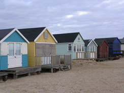
Pass the trig pillar and continue on eastwards as the path parallels the top of the cliff. It passes a coastguard radio station. Shortly after this it curves to the left; as it does so turn right down another path that descends to pass an old quarry before continuing to parallel the cliff top. When it reaches the eastern point of the headland, turn right down some steps that lead down onto the spit. Either follow the beach northwards, either the track on the western side of the beach huts or the beach on the eastern side. Either way, make your way towards the ferry jetty at SZ182912.
The ferry takes you over the mouth of Christchurch Harbour to Mudeford Quay, landing at SZ182916. If you wish to only walk around Christchurch Harbour then the next three paragraphs (describing a to and fro walk along the coast) can be ignored. Walk past the quay and head through the car park with the sea on the right. A promenade starts at the end of the car park; join this and follow it northeastwards along the coast. The coast slowly curves to take a more easterly course; when the promenade ends continue on along the coast until the end of Chewton Bunny is reached at SZ218931.
Here you can either walk back along the shore to Mudeford Quay, or otherwise climb up to the car park at the top of the cliffs. Continue westwards along the edge of the cliffs for a third of a mile until it turns to the right to head inland; just before this, turn left down steps onto a path. This climbs and falls as it heads westwards; eventually you are forced down towards the shore once more.
Eventually a zigzag path is reached at about SZ204930. Climb up the path to reach the top of the cliffs near to Highcliffe Castle. At the top turn left and head westwards along a path through the trees. It passes between a car park on the right and the cliff edge before passing a gate to enter the Steamer Point Nature Reserve. Continue on, passing close to the cliff and past a house. Shortly after this the path descends, becoming a track as it meets the promenade. Continue on southwestwards along the promenade back towards Mudeford Quay.
Head past the lifeboat station from the quay and walk on with the car park on the right and a boat store on the left. Immediately after the boat store turn left along a path that heads northwards across an area of grassland. This crosses a footbridge over a stream before immediately ending at Chichester Way. Follow the road for a few yards and then turn left, still along a one-way branch of Chichester Way.
This road soon ends at a T-junction with Mudeford. Turn left and follow this road northwestwards; it soon starts winding around. After 0.8 miles on the left at SZ172924 turn left down a track beside a car park. Follow this track as it heads southwestwards to enter the Stanpit Marsh Nature Reserve. It crosses a bailey bridge over a creek and then approaches the shoreline of Christchurch Harbour. Here turn right and follow a path that initially heads along the foreshore, crossing a series of footbridges over creeks. The shoreline is soon left behind and the path continues on with a creek on the left until a gate is reached at SZ168924.
Go through the gate and turn left along a track for a short distance. AS the track curves to the right turn left to climb up and join a footpath that skirts an area of raised, reclaimed ground, with a golf course on the right. The path loops around before descending some steps to meet a track. Head inland along this track to a car park; head through the car park and past a building to reach Bridge Street in Christchurch.
Turn left and follow Bridge Street westwards, crossing two bridges over streams of the River Avon. Immediately after the second bridge turn left along a path that runs between the river and a millstream, with the ruins of the Constable's House on the other side of the stream. The path passes the end of the Priory church before curving to the right and reaching a stone bridge over the stream. Cross this bridge and turn left to pass the Place Mill and reach the quay. Continue along the path around the banks of the River Stour until SZ155923, where a ferry often operates the short distance across the river.
If the ferry is not operating then pass the ferry landing and then turn right up Sopers Lane. Take the first road off to the left, Willow Way, and follow it westwards until it ends at the B3059 road. Turn left and follow the B3059 as it crosses the Stour. Immediately on the other side of the bridge turn left along a path that heads along the southern bank of the river to reach the ferry landing at SZ155921.
The ferry lands on the southern side of the river at SZ155921. Turn left and follow the path that runs alongside the river for a short distance. At SZ157921 the path turns to the right through a stile to head inland; it continues to curve around to the right to enter a large field. Turn left and follow the hedge of this field southwestwards with marshland over the hedge to the left. At the end of this field a stile leads to a good path that heads in a rough southeasterly direction for a little over half a mile before joining a track at SZ165912. Turn right and follow the track southwards for a short distance until the cafe beside the Hengistbury Head car park. Pass the cafe and enter the car park, where this walk ends.
 |
 |
|
Distances
| From | To | Distance (m) | Ascent (ft) | Descent (ft) |
|---|---|---|---|---|
| Hengistbury Head | Ferry | 2.2 | 223 | 230 |
| Mudeford Quay | Mudeford Quay via Chewton Bunny | 5.5 | 331 | 331 |
| Mudeford Quay via Chewton Bunny | Hengistbury Head | 5.3 | 59 | 56 |
This makes a total distance of 13.0 miles, with 613 feet of ascent and 617 feet of descent.
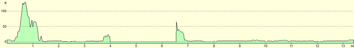
For more information on profiles, ascents and descents, see this page
Transport
Although in essence a circular walk, this walk relies on two ferries. If the second ferry across the Stour is not running then a diversion can be made of only a mile; however the first ferry across the mouth of Christchurch Harbour must be running for this walk to be possible.
The Mudeford Ferry operates across the mouth of Christchurch Harbour every day during British Summer Time (weather permitting), and at selected other times (especially weekends). Always check their website before relying on theitr service.
The Wick Ferry runs every day from Easter until October, and at select other times during the rest of the year. If the ferry is not running then a pleasant amble leads to a bridge over the river.
 |
 |
|
 |
 |
|
 |
 |
|
 |
 |
|
 |
 |
|
 |
 |
|
 |
 |
|
 |
 |
|
 |
 |
|
 |
 |
|
 |
 |
|
 |
 |
|
 |
 |
|
 |
Disclaimer
Please note that I take no responsibility for anything that may happen when following these directions. If you intend to follow this route, then please use the relevant maps and check the route out before you go out. As always when walking, use common sense and you should be fine.
If you find any information on any of these routes that is inaccurate, or you wish to add anything, then please email me.
All images on this site are © of the author. Any reproduction, retransmissions, or republication of all or part of any document found on this site is expressly prohibited, unless the author has explicitly granted its prior written consent to so reproduce, retransmit, or republish the material. All other rights reserved.
Although this site includes links providing convenient direct access to other Internet sites, I do not endorse, approve, certify or make warranties or representations as to the accuracy of the information on these sites.
And finally, enjoy your walking!
Nearby walks
| # | Title | Walk length (miles) |
|---|---|---|
| 310 | Bucklers Hard to Milford on Sea | 19.0 |
| 311 | Milford on Sea to Southbourne | 16.9 |
| 312 | Southbourne to Hamworthy Station | 15.3 |
|
|

|