Walk #876: West Parley to Blandford Forum
 |
 |
|
General Data
| Date Walked | 13/12/2010 |
| County | Dorset |
| Start Location | West Parley |
| End Location | Blandford St Mary |
| Start time | 08.322 |
| End time | 14.35 |
| Distance | 19.5 miles |
| Description | This was an enjoyable stroll following the Stour Valley Way across Dorset. |
| Pack | Today I carried my 30-litre Karrimor rucksack, filled with water, my waterproofs, a couple of books and other odds and ends. |
| Condition | My legs are slightly tired after this walk, but otherwise I am fine. |
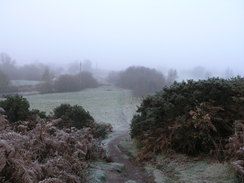
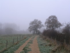
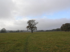
| Weather | Today started off cloudy and misty, which only started to lift as the afternoon arrived. It was a blisteringly cold day with a heavy frost on the ground in the morning, although thankfully there was little wind to worsen the chill. |
| OS map | Landranger number 195 (Bournemouth & Purbeck, Wimborne Minster & Ringwood) |
 |
 |
|
Map of the walk
Maps courtesy of Google Maps. Route for indicative purposes only, and may have been plotted after the walk. Please let me have comments on what you think of this new format. For a detailed table of timings for this walk, please see the table file.
 |
 |
|
Notes
I wanted to see if I could complete the Stour Valley Way before the end of the year, so I was keen to get a good distance of the path done today. A study of the timetables showed that I could get a long walk done from where I ended the last walk at Dudsbury to Blandford Forum, before two busses and a mile walk would get me back. I therefore set off early this morning to get to the Dudsbury Inn so I could start the walk. I was unsure if I could park in the pub's car park for the day; it is something that I usually try to avoid. However there were no suitable local car parks, and the local roads did not seem like good places to park. In the end I decided to park in the pub's car park, with the excuse that I had bought a couple of pints there a few days before.
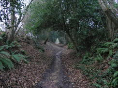
It was a bitterly cold morning and more than a little foggy. A good path took me across the Dudsbury Rings Iron-age promontory hillfort, which was so much on the promontory that a third seems to have fallen off the edge! There was little trace of the banks or ditches due to the heavy overgrowth, making it a drastic let-down when compared to the magnificent Badbury Rings hillfort nearby. At the far side there was an area of land that might have been a better place to park, although I have no idea if it is usable by the public.
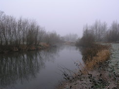
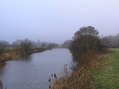
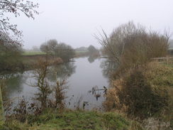
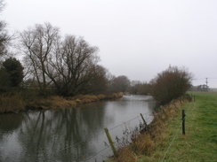
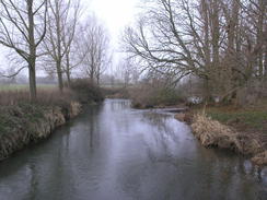
The skies were a little misty as the path descended steeply down to the valley floor, granting me sight of the River Stour for the first time today. The next stretch of walk was fairly pleasant, although less so when it dumped me out onto the busy A348 main road. This was used to cross the river via Longham Bridge, after which the path took a looping route over a very pleasant stretch of ground, albeit in the river's company for only a short distance.
I got slightly misdirected near the end of this stretch, and ended up following a path through woodland back to the main road rather than taking a more direct route. This confused me when I finally reached the tarmac, and I walked the wrong way for a few yards before turning back to find the correct path.
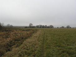
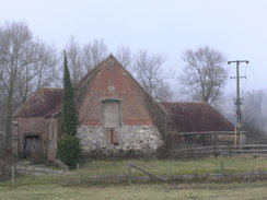
After crossing the road a good track took me on northwestwards across the floodplain. It was a fairly uninteresting walk, with little to see aside from the hedges on either side. The path passed the end of a road at Knighton before continuing on. I was surprised to find myself in the company of a golf course that was not marked on the map. No sooner had I left this one behind than I reached another in the grounds of Canford School. I exchanged pleasantries with a couple of golfers before carefully crossing the fairways to reach a road in Canford Magna.
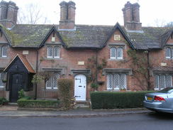
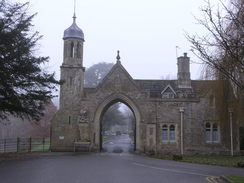
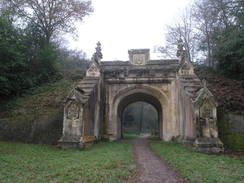
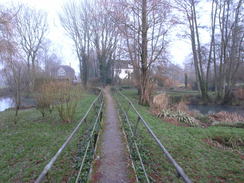
Rows of pretty cottages lined the road in the village, all with individual stone-carved numbers above the door. It was a very pretty place, and it only got better as I left the road and headed down to reach the river. A grand archway to the right leads in towards Canford School, which is formed of many spectacular-looking buildings that once belonged to Canford House. A good track led on, not following the river but heading slightly inland, passing under a main road and then a much more spectacular bridge - the stone-built Lady Wimborne Bridge that at one stage carried the famous Somerset and Dorset railway line over the track. This bridge is indescribably ornate, and is ordained with pinnacles and other details. Unfortunately it looks as though the bridge is suffering slightly, and could do with some small repairs. Some tree clearance may also allow far better views of the structure.
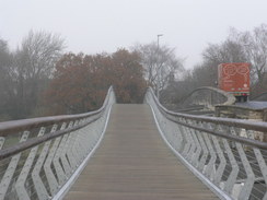
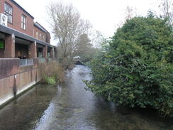
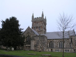
A road was joined for the walk into Wimborne Minster, and this included another crossing of the River Stour. Last time I walked this way I had to take my life into my hands by crossing the road bridge, but I was pleased to see that a new pedestrian footbridge had been built alongside; apparently it had only recently opened. This led me into the town itself, which I have always liked. It is a typical market town that is centred around the minster, which dates from the early 1100s but is on the site of an older church from 705.
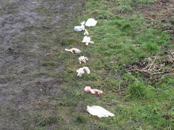
The trail left the town via the allotments. A line of small plastic bags sat beside the path at the exit to the allotments, each, I assume, containing dog droppings. I cannot quite understand why people bag up their dog's business and drop it beside the path instead of carrying it to a bin; it seems a particularly obnoxious form of littering.
This led to a short stretch of path along the floodplain, and although close by, there were not many views over the river. There then started a diversion; the Stour Valley Way climbs uphill through Pamphill for no discernable reason, except perhaps to avoid the quiet road along the valley floor. The path actually splits into two at the first part of this stretch, again for no discernable reason, the other route being just a few hundred yards long, and I did not bother doing it.
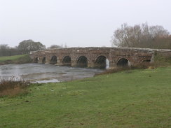
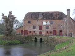
It jigged up and down following a series of unsurfaced lane, before joining the road in the valley and then heading off across fields towards the graceful 16th-Century White Mill Bridge, beyond which lay the White Mill itself. The bridge includes a sign stating that the penalty for wilfully injuring the bridge was transportation to Australia! I can only hope that that particular penalty has been rescinded...
A long and fairly uninteresting walk across the floodplain now led to Shapwick. Last time I was in village a hunt passed through; today it was much quieter. I noted that I had managed to keep up a little over 3 miles per hour so far during the day, and it seemed like a sensible idea to try and maintain that rate. The next stretch of walk to Crawford Bridge was familiar but far from unpleasant, although again the river was not in view until just before the bridge was reached.
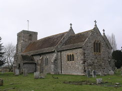
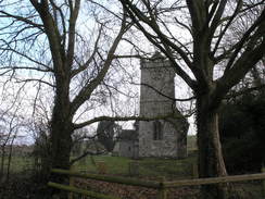
Another diversion from the valley floor followed, this time heading north towards the ruins of Tarrant Abbey, now assimilated into a farm. The grade-1 listed St Mary's church is no longer used for services, but is being maintained by the Churches Conservation Trust. I did not go in, but apparently it has some 14th Century wall paintings in a good condition, some of the few to survive the reformation. It was an interesting diversion, especially when compared to those earlier in the day.
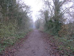
A pleasant stretch of path stretched away from Keynston Mill, crossing several tributaries of the river by footbridges. The river looked particularly pleasant today, and the walk was suitably enjoyable. It led to a main road that had to be crossed to reach a stretch of the old Somerset and Dorset railway line. Parts of the route in this area are being reopened as footpaths, although at the moment it is a very fragmentary affair, with large gaps between the opened sections. Hopefully at some time it will all be connected up, but my impossible preference would be for the whole thing to be reopened as a railway line. It would be wonderful to travel between a steam train between Bournemouth and Bath again one day.
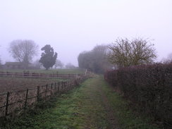
The stroll along the old railway line ended at some platforms, and then the valley was reached once more. Unfortunately the river was not to be seen as a track and then a footpath took me northwestwards. The last part of the walk towards Blandford Forum was not too nice; a long walk along a busy main road. Fortunately there was a pavement that at least made the walk safe, if not enjoyable. I was still keeping up a good pace, although my legs were starting to feel more than a little tired.
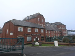
I mentally calculated the chances of getting to Blandford Forum before the bus to Poole set off. It was going to be very tight, especially as I would have to find the bus stop in the town. After passing a large supermarket I reached the Hall and Woodhouse brewery, and I noticed a bus stop directly outside. The sign stated that this was the correct bus, so instead of heading further on into the town and risking catching the bus, I decided to wait for the twenty minutes. So I waited. And waited. And waited. There was nowhere to sit and it was very cold, so I slowly started shivering as I lost the warmth I had built up during my brisk walk.
Ten minutes after the bus was due I asked the youth waiting with me whether it was the right stop; he was waiting for the same bus. Eventually the bus arrived about half an late. There was no chance of getting the connection back towards my car, so I resigned myself to a long wait in Poole. I was still chilled, so instead of waiting around in the bus station I nipped into a chip shop and scoffed down a pack of chips. This helped warm my spirit as well as my body, and I felt much better as I waited for the next bus. This dropped me off about a mile away from the car, so the last mile of the day (not counted in the above total) was along the B3073 from Longham back to Dudsbury.
 |
 |
|
Directions
This walk starts off at the car park of the Dudsbury Inn at SZ079978, and follows the Stour Valley Way for the entire way. At the entrance to the car park, take a footpath that heads off to the west. It passes the garden of a house on the left and continues westwards through trees. It emerges out of the woodland and heads across an area of grass, before skirting more trees to reach the edge of an unsurfaced area of ground. Turn right across this ground and then turn left along the access driveway; when this curves to the right turn left along another footpath.
This heads steeply downhill through the trees before emerging out into fields. An obvious path heads southwestwards to join the northern bank of the river. Follow the path alongside the river as it winds southwestwards for two-thirds of a mile until it ends at the A348 at a layby in Longham. Turn left and follow the lay-by, and then the main road, as it curves to reach Longham Bridge over the river.
Cross the bridge, and on the southern side turn left along another footpath. Initially this heads downstream with the river on the left, but as the river curves slightly to the left continue straight on with scrubland to the right. Soon the trail curves to the right along a good path that initially heads in a rough southerly direction. It joins a little stream on the left, and winds with this until a road is reached by a bridge over the stream.
Cross this road and continue following the good path with the stream on the left. Eventually the path angles away from the stream; sometime during this turn left along another path that heads for a short direction in a rough westerly direction to reach the A348 road at SZ059969.
Carefully cross the A348 and join a track that heads westwards across the floodplain. It curves to the right to take a more northwesterly course, and three-quarters of a mile after the main road it curves to the left to reach the end of Knighton Lane. Cross this and continue on westwards along a track that passes immediately to the north of Knighton Farm. This joins a surfaced track that heads northwestwards across a golf course.
When a triangular road junction is reached at SZ039981 turn left along the base of the triangle, then go through a large gate to head westwards along a path across another golf course. This cuts through a band of woodland before passing between some playing fields and reaching a track. Cross this track and head westwards, initially with a car park on the left, until the path ends at a road in Canford Magna.
Turn right and follow the road northwards for a third of a mile. When the road curves sharply to the left, continue straight on down a track that leads to the southern bank of the river, with a gateway leading into Canford School on the right. At the riverbank, turn left along a track that follows the southern bank of the river westwards for nearly a mile. It passes under the A31(T) road, and then under a beautiful old railway bridge. After passing under the bridge it passes some houses and goes through an ornate gate before ending at the B3073 road.
Turn right and follow the B3073 road northwards, almost immediately crossing the river by a new pedestrian footbridge on the upstream side of the road bridge. Continue on for a third of a mile until Poole Road leads off to the left. Follow this road until it ends at the B3073 on the eastern side of Wimborne Minster.
Turn left and follow the B3073 westwards. When it ends at a T-junction, continue straight on along East Street, which immediately crosses the River Allen. Continue on westwards along the B3073 through the town, passing the church of Wimborne Minster on the right. The road curves to the right to reach a roundabout; cross this and after a few yards turn left down Old Road. Follow this as it curves to the right, becoming Cuthbury Close.
Almost immediately the close curves to the left; here continue straight on along a track that heads northwestwards between allotments. When the track forms take the left-hand fork and follow it to the western side of the allotments. A footpath then leads onwards for about a third of a mile with the river close-by on the left. Cross two hedgelines; just before the third turn right to head away from the river along an obvious path. This passes through one hedge and curves to the left to pass through another; immediately after this it turns to the right to head a few yards to end at the Cowgrove Road at ST996002.
Here the Stour Valley Way splits for a short distance. The easiest route crosses Cowgrove Road and heads up Vine Hill Road. It passes a pub on the right and a school; the gradient slackens out and after half a mile it ends at Abbott Street at ST989008. Turn left and follow this road westwards for 150 yards, then turn left down a green lane called Fools Lane. Follow this as it twists and turns for a little over half a mile before ending at Sandy Lane. Turn right up this lane and follow it northwards for a third of a mile.
When the road curves to the right at ST978007 turn left to pass through a car park and join a green lane that heads westwards. When the lane curves to the right after a third of a mile turn left down another green lane that heads southwestwards for two-thirds of a mile before meeting Cowgrave Lane at SY965999.
Turn right to had along the lane for a couple of hundred yards, and then turn left through a stile beside a gate. The path angles away slightly to the right of a track; it crosses a stile over an area of rough ground and then meets the northern bank of the river. The path then curves to the right to start following the river northwestwards. As White Mill Bridge becomes visible on the left the path angles away with a hedge on the right before going through a metal clappergate to reach a road.
Turn right and follow the road as it curves to the left to pass White Mill. About twenty yards after a road comes in from the right, turn left to cross a stile and head down to the floodplain. Turn right to follow the northern bank of the river westwards, and then as it curves around to the left. Stay near the river until nearly opposite Sturminster Marshall church; here the path turns to the right to head west-northwestwards across fields roughly fifty yards or so away from the river.
Eventually the footpath meets the river as the latter curves to the right, and is followed north-northeastwards towards Shapwick. It joins a track for a short distance, then turns to the left to cross a footbridge and head towards Shapwick church. The path reaches the hedge guarding the churchyard, then turns right to access a car park. Walk through this to reach a road; turn right along this and follow it as it curves to the left to reach the war memorial near the Anchor Inn in the centre of the village.
Turn left and follow West Street which heads northwestwards out of the village. When it curves to the right continue straight in along a track. This curves to the left and then the right until a bridge if reached over a stream. Cross the bridge, and then head westwards across the floodplain of the River Stour, crossing a series of fields on the way. The footpath ends at a road by Crawford Bridge at ST919021.
Turn right to head north along the road for a couple of hundred yards, then turn left through a gate into a field. Follow this for a short distance to the western edge of the field and then turn right along the field with a hedge on the left. At the top-left hand corner of the field turn left and then right to head northeastwards along a track; this crosses another track before reaching a gate that leads out onto a road at ST920029.
Cross the road and cross a stile beside a gate opposite. This leads into a field; head north diagonally across this field. It passes through a hedge and curves to the right, angling downhill past Tarrant Abbey Farm to reach a track beside Tarrant Crawford church. Walk towards the church, then turn left along a track that immediately crosses The Tarrant stream. It then curves to the left to pass on the other side of the farm and head southwestwards to end at a road at ST917032.
Cross this road, turn left for a few yards and before a bridge turn right through a gate into a field. Follow a footpath westwards along the edge of the field with a stream on the left; the path follows the stream as it curves to the right to take a more northerly direction before ending at a road near Keynston Mill. Turn left down a track southwestwards passing the mill on the right, immediately crossing a stream of the River Stour on a footbridge.
Continue straight on southwestwards; the path crosses another stream on a footbridge; ignore all paths and tracks that lead off and head towards some trees that leads to a third footbridge. Cross this, and on the other side take a footpath that heads across a causeway that ends at another track beside Clapcott's Farm. Continue down this track for a short distance until the A350 road is reached in Spetisbury.
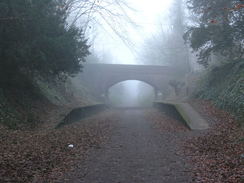
Carefully cross the A350 and head straight on westwards along West End. Shortly after a school is passed on the left and before a bridge under an old railway line is reached, turn left up a path that slopes uphill to reach the trackbed. Turn right and follow the railway trackbed northwestwards for a mile until the platforms of the old Charlton Marshall station are reached at ST896040. Climb up onto the right-hand platform and take a sloping path that leads up to a road. Turn right and follow this road northeastwards for a couple of hundred yards until it ends at the A350.
Carefully cross the A350 once more and continue straight on along Gravel Lane. This immediately curves to the left to head in a rough northerly direction. When the lane end at a T-junction with a track, turn half-left to head westwards across a field to reach the A350 once more at about ST895047. Cross the A350 once more and turn right to start following the road northwestwards for two-thirds of a mile until a roundabout with the A354 is reached in Blandford St Mary. Take the second exit to continue straight on along Bournemouth Road for a quarter of a mile. This walk ends at the bus stop beside the entrance to the Hall and Woodhouse brewery.
 |
 |
|
Distances
| From | To | Distance (m) | Ascent (ft) | Descent (ft) |
|---|---|---|---|---|
| Dudsbury | Wimborne Minster | 6.6 | 194 | 240 |
| Wimborne Minster | Shapwick | 6.7 | 253 | 226 |
| Shapwick | Blanford St Mary | 6.2 | 292 | 249 |
This makes a total distance of 19.5 miles, with 739 feet of ascent and 715 feet of descent.
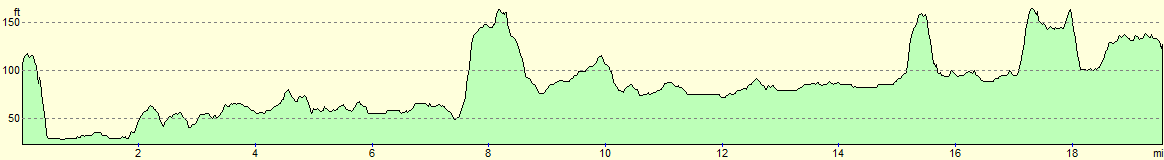
For more information on profiles, ascents and descents, see this page
Transport
There are no direct services between Blandford St Mary and Dudsbury; instead, I took two buses. The Wiltshire and Dorset service X8 took me from Blanford St Mary to the main bus station in Poole. This bus runs roughly every hour during the week. From Poole, I took the Wiltshire and Dorset bus 37 from Poole to the White Hart Inn in Longham. From there, I had a walk of a little over a mile back to Dudsbury and my car.
 |
 |
|
 |
 |
|
 |
 |
|
 |
 |
|
 |
 |
|
 |
 |
|
 |
 |
|
 |
 |
|
 |
 |
|
Disclaimer
Please note that I take no responsibility for anything that may happen when following these directions. If you intend to follow this route, then please use the relevant maps and check the route out before you go out. As always when walking, use common sense and you should be fine.
If you find any information on any of these routes that is inaccurate, or you wish to add anything, then please email me.
All images on this site are © of the author. Any reproduction, retransmissions, or republication of all or part of any document found on this site is expressly prohibited, unless the author has explicitly granted its prior written consent to so reproduce, retransmit, or republish the material. All other rights reserved.
Although this site includes links providing convenient direct access to other Internet sites, I do not endorse, approve, certify or make warranties or representations as to the accuracy of the information on these sites.
And finally, enjoy your walking!
Nearby walks
| # | Title | Walk length (miles) |
|---|---|---|
| 311 | Milford on Sea to Southbourne | 16.9 |
| 312 | Southbourne to Hamworthy Station | 15.3 |
| 313 | Hamworthy Station to South Haven Point | 18.0 |
|
|

|