Walk #819: North Baddesley to Southampton
 |
 |
|
General Data
| Date Walked | 30/07/2008 |
| County | Hampshire |
| Start Location | North Baddesley |
| End Location | Southampton city centre |
| Start time | 08.30 |
| End time | 15.18 |
| Distance | 17.0 miles |
| Description | This a walk of three parts; a long walk through Chandler's Ford to reach the Itchen Way, was followed by a long walk southwards along that footpath. The final part is a walk through the centre of Southampton to the Borders bookshop. |
| Pack | Today I carried my 30-litre Karrimor rucksack, filled with waterproofs, a book and other odds and ends. |
| Condition | I feel absolutely fine after this walk; I had no trouble with my right ankle, which I twisted a few weeks before. |
| Weather | The day started off with some hazy cloud in a blue sky; as it progressed the cloud started to clear, leaving generally blue skies behind. It was a warm day, but fortunately not too hot. |
| OS map | Landranger number 185 (Winchester & Basingstoke, Andover & Romsey) and Landranger number 196 (The Solent & The Isle of Wight, Southampton & Portsmouth) |
 |
 |
|
 |
 |
|
Map of the walk
Maps courtesy of Google Maps. Route for indicative purposes only, and may have been plotted after the walk. Please let me have comments on what you think of this new format. For a detailed table of timings for this walk, please see the table file.
 |
 |
|
 |
 |
|
Notes
I had not done any walks for seven or eight weeks due to a number of factors; moving house, trips to visit family and friends, and a badly twisted ankle. I therefore wanted to do something quite local. One of my planned walks was to complete the Itchen Way down from Chandler's Ford towards Southampton. I had planned to do this from our old house in Romsey, but now we had moved it seemed like a good opportunity to follow my old moving-house rule: to start my first walk after moving from my new house.
I was more than a little concerned because of my right ankle. I had twisted this badly when moving into the new house (on the new doormat, of all things). It was the same ankle that I twisted when going down Scafell Pike in 2003, and it had never fully healed. The new injury was worse than that time, and the ankle was still weak and painful. However, I knew from experience that wearing boots kept the ankle stable and allowed me to walk with such an injury, so I set off.
The first stretch of the walk was familiar to me; I had cycled along it on many occasions. A road took me up to the main road through the village, and I then joined Castle Lane, a road that runs (as far as I can tell with no castle) all the way to Chandler's Ford. This road is fairly busy, but fortunately there was an off-road cycle path that kept me off the road. The views from this to the left were pretty in places; it overlooks the woodland of Great Covert on the left.
At the end of Castle Lane a series of roads took me northeastwards towards Chandler's Ford through a large industrial estate. Ordinarily this would have been a boring and uninteresting stretch, but (if you can have such a thing) it was actually quite a nice estate. There was grass and some trees, and some of the firms were unusual - GE Aviation for instance (Southampton Airport is only a short distance away).
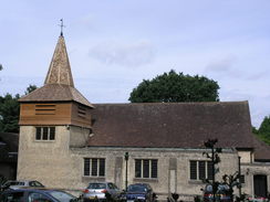
My route passed the railway station in Chandler's Ford and headed on northeastwards through the town. The Catholic church was unusual - it was of a style far more at home in the country than in the middle of a town, with a wooden spire. Despite this, it was a welcome addition to the town.
When the road hit the M3 I dived under and underpass to reach the southern tip of the long linear village of Otterbourne. This was the first time on the walk that I actually felt as though I was in the countryside; off to the left was a large area of grass, perhaps a village green, outside the Otter pub. It all looked like a very pleasant place to live; fairly near to the amenities of Chandler's Ford, yet near woodland and pleasant views. The road took me down to meet the B3335 in Allbrook, the place where I had left the Itchen Way on the previous walk last year.
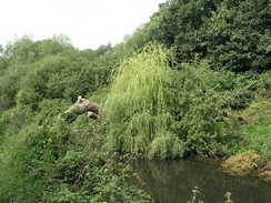
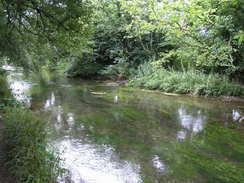
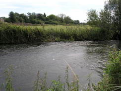
Joining the Itchen Way meant that the start of the scenic stretch of the day's walk. Initially the canal is in water as it snakes southwards, although fallen trees that block it shows that it is no longer navigable. At one point some green portakabins were reflected in the water - a strangely pleasant sight. It passes under the Southampton to Winchester line twice, and then heads on along a pleasant stretch to reach the B3037 at Bishopstoke.
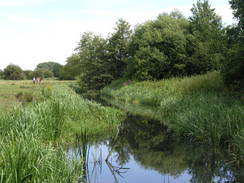
The next stretch should have been equally pleasant, but unfortunately it was very overgrown with thistles, brambles and nettles, and I was only wearing shorts. My progress was slow as I tried to pick my way carefully along the path, passing the site of Conger Lock as my legs got stung and shredded. it was not very pleasant, and it was a relief when the trails followed a track that skirted the outside of a sewage works. From here to the M27 the canal had been dewatered, although this stretch had been totally filled in. The smell of the sewage was unpleasant, but I was just glad that I was out of the vegetation.
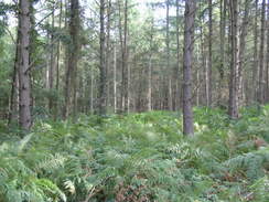
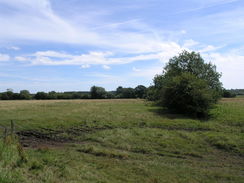
The canal sound roughly southwards, with Southampton International Airport to the west and a country park to the east. The canal bed becomes visible once again, as a tree-filled and sometimes boggy depression to the right. I really enjoyed this stretch of the stroll, and the trees kept the sun off me, as well as the cover preventing the path from becoming overgrown. The previous Sunday the company that my partner works for had a barbecue at the Itchen Valley Country Park, a short distance to the east.
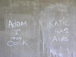
The noise of the M27 dominated as I headed south, and then the old canal reached the embankment that carried the motorway. There was no bridge through the embankment, and instead the path headed eastwards along its base to reach a branch of the River Itchen. There was a low concrete bridge under the motorway here, complete with the obligatory graffiti. On the other side a path took me along the other side of the motorway embankment, through a field prettily filled with gorse bushes and other yellow flowers.
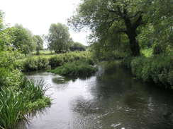
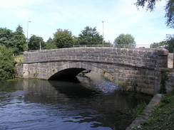
I was surprised to find that the old canal bed on this side of the motorway had some water in, although it was nowhere near full. It continued on for only a short distance before joining the River Itchen just before the A27 bridge. Immediately on the other side of this bridge is a lovely stone arch bridge called Mans Bridge; children were jumping into the river beside this. The northern aspect of this bridge is slightly spoilt by a curved pipe that is attached to its side; the southern aspect is far better, and even blocks out the views of the M27 bridge.
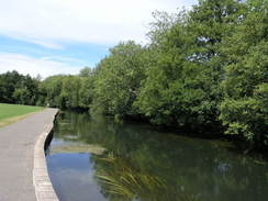
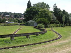
After Mans Bridge the path passed through a riverside park; an enjoyable stroll in the sunshine, with many people out and about, with the river to my right. Just before Woodmill Lane was crossed I stopped off to buy an ice cream, a welcome relief as it was starting to get hot. The path continued on southwards, passing a miniature railway that unfortunately was not running. At Cobden Bridge the Itchen Way had to leave the riverside, taking a series of roads southwards. The waymarkers for the Itchen Way were intermittent, and in the end I picked my own route towards Bitterne station, and it was only when I looked at my GPS log at home that I realised that I had taken the correct route. Unfortunately that was not the case for the next stretch to the south of the station, where the Itchen Way took a loop to the west and I headed on straight down a road.
Over the next mile or so I went wrong on a couple of occasions, missing out the path that headed down Chine Avenue. At another point, however, I was forced to go wrong; on Gainsford Road the Itchen Way headed up some steps to the left, and this was blocked off by barriers due to a new housing development alongside. The housing development appeared to be complete, so I was left wondering why it was still blocked off. Fortunately the diversion was not too long, and I soon ended up at the same place for the walk down past Peartree Green. Over the river I could see St Mary's Stadium, the home of Southampton football club, and head I got my first glimpses of the enormous Itchen Bridge.
At the bottom of the hill was the Yacht Tavern, and I nipped in there for a rest. I had a pint of bitter and another of orange and lemonade, whilst I read a newspaper. It was a pleasant pub, and very much had a nautical atmosphere, although admittedly it is difficult to say why it left such an impression. Regardless, it was a handy place to take a rest and consider what I would do for the rest of the day. I could have extended the walk by going down to the end of the Itchen Way in Woolston before walking back to the Itchen Bridge, but in the end I decided just to cross the bridge. This would mean that it would be a short walk, but after such a long break from walking that was not a bad thing.
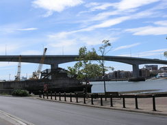
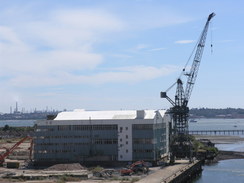
I was looking forward to crossing the Itchen bridge; it is an imposing and surprisingly graceful concrete structure that dominates the surrounding area. I clambered up the steps that led onto the top of the bridge, then started walking along the path that ran alongside the southern carriageway. When I had last walked along here on Christmas Day 2002 there had been a couple of Royal Navy ships berthed by the large buildings - dockyard? - at Woolston, and I was looking forward to seeing what was there now. The answer, unfortunately, was not much. Most of the buildings had been cleared, and a machine was slowly nibbling away at the one solitary one remaining. Beside it, the dockyard crane stood, unloved. It seemed a sad that the site had been demolished, to be replaced, I guess, with yet another riverside housing development.
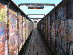
On the western side of the bridge I passed under a subway before reaching some brick steps; this led up to a long footbridge over the old railway line leading to the docks. This was covered with graffiti, and despite its length only carried one track underneath it. Indeed, there were buildings built on the trackbed on the western side, and the bridge went over and past them. I then walked through the centre of Southampton, going through the small East Street shopping centre before reaching the pedestrianised centre of the city.
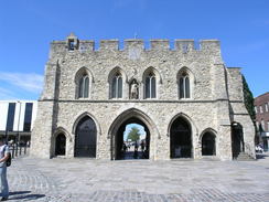
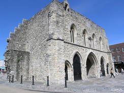
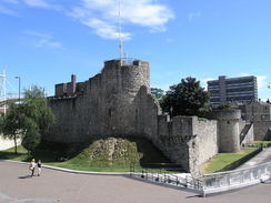
Slightly uphill was the Bargate, a stunning stone gateway that was once part of the Medieval town walls. A surprising amount of these walls remain, particularly on the western and southern sides, having survived redevelopment and the Blitz that devastated much of the city. I climbed up some metal steps to join a short section of the city walls, crossing a bridge to reach a tower, then walked through to the Borders bookshop, where I decided to end the day's walk.
 |
 |
|
 |
 |
|
Directions
This walk starts off outside my new home at Ennel Copse in North Badddesley. Leave Ennel Copse, and turn left to start heading northeastwards up Rownhams Lane. When this meets the A27 Botley Road at a traffic-light controlled crossroads, turn right to start following the A27 southeastwards. At the first opportunity cross the road, and then at the next traffic lights turn left to start following Castle Lane eastwards. There is a cycle path just to the left of the road, and follow this for about one and a third miles as it passes to the south of Great Covert.
When Castle Lane ends at some traffic lights, cross the road and turn right down Templars Way for a few yard. When a lay-by is reached on the left, pass a small hedge on the left and cross a patch of grass to reach the end of a disconnected stretch of Castle Lane. Head eastwards along this until it soon ends at a T-junction with School Lane. Turn left, and start following School Lane as it heads northeastwards for nearly a mile through an industrial estate. It eventually curves to the right to take a more easterly course, before climbing and ending at a T-junction with the B3043 Bournemouth Road.
Turn left along the B3043 for a short distance as it crosses a bridge over a railway line next to Chandler's Ford railway station and reaches a roundabout. Continue straight on along Winchester Road, and follow this northeastwards through Chandler's Ford for 1.7 miles until a roundabout is reached at a junction with Hocombe Road on the left. Turn right to cross the M3, and on the eastern side of this take a path that leads off to to pass under the road. On the other side follow a road called Otterbourne Hill northwards, initially paralleling the M3 motorway.
After a short distance turn right down Boyatt Lane, passing the Otter Pub with an area of grass on the left. At a complex junction turn right to walk southwards down Boyatt Lane. A fifth of a mile from the bend turn left down Pitmore Lane, and follow this southeastwards for a little over half a mile until it ends at the B3335. Turn left and follow the B3335 for a short distance as it passes under a railway bridge. On the other side there is a stream and a footpath leading off to the right, following the Itchen Way.
The Itchen Way is followed for about nine miles southwards. Initially it follows the eastern bank of the old canal, which is in water, passing under a railway bridge and looping around to pass under another a little under half a mile later. After this bridge it continues on the eastern bank for a short distance, before crossing over to the western bank on a footbridge. It then follows the western bank southwards for 0.8 miles until it reaches the B3037 road in Bishopstoke.
Cross the B3037 and continue southwards along the Itchen way. A footbridge is reached where the old towpath crosses over to the eastern bank at the site of the old Conegar Lock; then shortly after this another footbridge is reached that takes you across the canal and the adjacent Barton River.
For the next few miles the canal is dry; initially it follows a track southwards to the east of a sewage works, and after half a mile it passes under another railway bridge. The canal is little more than a depression to the right as the Itchen Way continues on along the old towpath, heading southwestwards for about 1.7 miles until it meets the northern bank of the M27. The path turns to the left to follow the base of the embankment eastwards for a couple of hundred yards until it reaches the bridge that carries a branch of the River Itchen under the motorway.
On the other side of the bridge, turn right to start following the southern embankment of the motorway westwards; eventually it meets the old canal, here in water, and follows the eastern bank southwestwards. It soon crosses over to the western bank, and continues on under the A27 until an old stone bridge called Mans Bridge is reached. Cross Mans Bridge, and follow the eastern bank of the canal, here in unison with the river, southwestwards for 0.6 mile until Woodmill Lane is reached.
The Itchen Way continues along the eastern bank of the river for nearly a mile until the large Cobden Bridge is reached over the river. Here the path leaves the side of the river; turn left and follow a path that climbs up onto the eastern approach to the bridge. Cross the road and turn left, passing a memorial on the left, then take the next road on the right, Whitworth Crescent. Follow this for a fifth of a mile until it jinks sharply to the left to head southeastwards along Whitworth Road. When this ends at a T-junction, turn right and follow Macnaughten Road as it curves to the left, passing Bitterne station and ending at a junction with the A3024 road.
Turn right along the A3024 and follow it as it crosses over the railway line, then turn right down Chafen Road. Follow this northwestwards for a short distance until it turns sharply to the left and becomes Vespasian Road. When this ends at a little area of parkland, head diagonally to the left to reach the A3024. Pass this, and on the other side join Quayside Road. Follow this eastwards as it skirts the estuary side. When the road ends, cross the railway line using a footbridge on the left that joins Athelstan Road.
Follow this road southeastwards, and just before it climbs up to end at a T-junction turn right down Chine Avenue. When this ends, continue straight on along another footpath that ends at another road. Continue straight on along this road, and follow it as it curves to the left to end at a T-junction with Gainsford Road. Turn right along this road, and when it curves to the right turn left to climb some steps that end at a road. Turn right along this road, and then turn left for a few yards up Osterley Road until it ends at a T-junction.
At the T-junction turn right along a surfaces track that heads away slightly to the right of Peartree Road, with parkland on the right. Follow this road southwestwards; the Itchen Way leaves he road and heads to the west of the houses on Peartree Green, but it ends up in the same place as the road. This descends downhill, passing under a railway bridge until ending at a T-junction.
Turn left and follow Hazel Road southwards, passing under the Itchen Bridge, then turn left along the edge of the bridge eastwards until some steps are reached that lead up the abutments. Climb these steps, and at the top turn left to head westwards across the bridge. Before the end of the bridge cross over onto the northern side, and then take a zig-zag path that heads down to a subway. Continue westwards through this, and join the end of Chantry Road. When this ends climb up some brick steps to a long footbridge stretching over an old railway line; on the other side continue on along Marsh Lane.
A road comes in from the left, but Marsh Lane continues on northwestwards. At some traffic lights cross over, and head westwards through the East Street shopping centre to reach East Street itself. Head westwards along East Street until it ends at a T-junction with High Street. Turn right to head north up High Street, until the large stone building of Bargate is reached. This could be a good place to stop the walk, but I continued on for a short distance to the Borders bookshop in the city.
Here turn left, and after a short distance by a bus stop turn left and climb up some steps that lead onto the city walls. Walk west along the city walls, crossing a gap by a large white bridge, until a tower is reached.
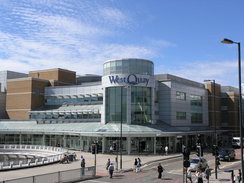
Descend down the tower and walk back along the walls towards the bridge; turn left, and then walk past the southern side of the West Quay shopping centre. When this meets harbour Parade, cross the road and turn right. Pass under a footbridge that leads to a multi-storey car park on the left, and then turn left to walk between shops on the left and a car park on the right. Borders is one of these shops.
 |
 |
|
 |
 |
|
Distances
| From | To | Distance (m) | Ascent (ft) | Descent (ft) |
|---|---|---|---|---|
| North Baddesley | Chandler's Ford station | 3.1 | 79 | 125 |
| Chandler's Ford station | B3335 road | 2.9 | 184 | 213 |
| B3335 road | Itchen bridge | 9.3 | 374 | 384 |
| Itchen bridge | Borders, Southampton | 1.7 | 43 | 59 |
This makes a total distance of 17.0 miles, with 680 feet of ascent and 781 feet of descent.
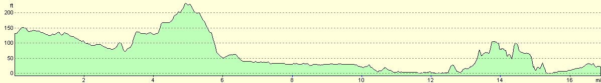
For more information on profiles, ascents and descents, see this page
Transport
There are regular bus services (every half-hour on weekdays) from the centre of Southampton to North Baddesley; the ticket costs £3.50 for a single ticket.
 |
 |
|
 |
Disclaimer
Please note that I take no responsibility for anything that may happen when following these directions. If you intend to follow this route, then please use the relevant maps and check the route out before you go out. As always when walking, use common sense and you should be fine.
If you find any information on any of these routes that is inaccurate, or you wish to add anything, then please email me.
All images on this site are © of the author. Any reproduction, retransmissions, or republication of all or part of any document found on this site is expressly prohibited, unless the author has explicitly granted its prior written consent to so reproduce, retransmit, or republish the material. All other rights reserved.
Although this site includes links providing convenient direct access to other Internet sites, I do not endorse, approve, certify or make warranties or representations as to the accuracy of the information on these sites.
And finally, enjoy your walking!
Nearby walks
| # | Title | Walk length (miles) |
|---|---|---|
| 306 | Browndown to Bursledon | 12.9 |
| 307 | Bursledon to Southampton | 9.2 |
| 308 | Southampton to Fawley | 16.4 |
|
|

|