Walk #792: A circular walk from St Mary Bourne to Inkpen Hill
 |
 |
|
General Data
| Date Walked | 30/10/2007 |
| County | Hampshire, Berkshire, Wiltshire |
| Start Location | St Mary Bourne |
| End Location | St Mary Bourne |
| Start time | 07.31 |
| End time | 16.10 |
| Distance | 24.1 miles |
| Description | This walk follows the northern end of the Test Way, and the western (start) of the Watfarers Way, before heading back to the start along roads. |
| Pack | Today I carried my 30-litre Karrimor rucksack, filled with waterproofs, a book and other odds and ends. |
| Condition | I feel fine after this walk. |
| Weather | Tpday was a lovely dayt, with bright sunshine and clear skies for most of the day, with only a few clouds for company. There was a stiff, chilly breeze that blew the clouds along, but it felt uite mild for the time of year. |
| OS map | Landranger number 185 (Winchester & Basingstoke, Andover & Romsey) and Landranger number 174 (Newbury & Wantage, Hungerford & Didcot) |
 |
 |
|
 |
 |
|
Map of the walk
Maps courtesy of Google Maps. Route for indicative purposes only, and may have been plotted after the walk. Please let me have comments on what you think of this new format. For a detailed table of timings for this walk, please see the table file.
 |
 |
|
 |
 |
|
Notes
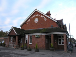
I still had two days of walking to do before I have completed the Test Way, one at the northern end of the walk and the other at the southern. It had been my intention to leave the northern end for last, but the clear weather forecast for today and the better scenery at the northern end combined to make me decide to do that first. As the clocks went back last weekend there was less daylight in the afternoon to complete walks,so I was forced to set off at six thirty for the drive north to the start of the walk. This went well, and after parking on the road near the Coronation Inn in St Mary Bourne I got my kit together and set off.
It was chilly this early in the morning and I unfurled my cap further to cover more of my head and ears as I walked the short distance to join the Test Way by a school. Initially the path climbed out of the village following a route that I had followed on the previous walk, and as soon as the top of the hill was reached some reasonable views were available. During the previous walk these had been obscured by the hazy sky and clouds, so it was nice to be able to see them on this trip. Soon the road where I had left the Test Way on the previous walk was left, and I started following the path as it slowly climbed, crossing a road where I skipped off a stile, scraping my right leg. Initially this caused me to limp, but before I reached Stokehill Farm the discomfort had eased and I was walking normally.
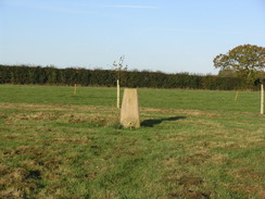
Here there were a couple of signs detailing footpath diversions, but these did not seem to affect the Test Way and so I continued on past the farm. There was a little area with some cricket stumps and high fences, and soon I diverted off the path slightly along an avenue of recently-planted trees to reach a trig pillar,my first of the day. There actually seemed to be a turning circle in the grassy avenue around the pillar that made it into a sort of feature, and I walked around this before returning to the path. This immediately passed a tennis court before continuing across fields and entering woods at Doles Copse. As I walked I scoffed the sandwiches that I had made this morning, eating them earlier than I had expected, but I was surprisingly hungry.
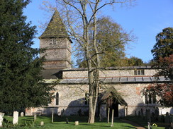
The walk through the woods was pleasant, even as it started to steeply descend downhill. Once out of the trees the descent slackened, and soon I was passing through a farm and passing a school playground that was packed with children to reach the village of Hurstbourne Tarrant. Here the map shows the route going uphill slightly past the church, but I could not see the path on the ground and so I followed the road through the village; I will have to come back here sometime to look for (and walk) the proper route. This forced me to join the A343 road for a short distance to rejoin the Test Way, and I walked on past the Way to visit the Post Office, where I bought a bottle of water and a couple of chocolate bars for the rest of the day.
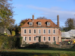
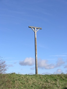
When walking out of the village the path kept low down initially as it headed towards Ibthorpe, where there was a large building - a manor house? - that was under heavy restoration. The entire rear of this appeared to have been removed, and a cast-iron fireplace was exposed to the elements on the first floor. The next few miles to Linkenholt were fairly unremarkable as the Way followed a track before finally joining a road for the last few hundred yards into the village. At one point an army helicopter flew overhead, one of many that I saw during the day, although this one was so low that I actually stopped to check that it would pass under the power lines to my right.
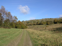
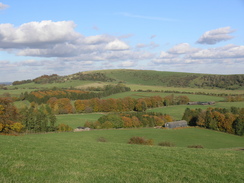
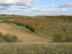
I was surprised to find that despite the fact that it was eleven in the morning the moon was still clearly visible in the sky ahead, and it would remain so for some time. Once past the small church in the village a track led me on to Hart Hill Down, where another track was joined that headed northwestwards along the valley bottom through some woodland, with feeders and bails of hay scattered around through the trees. The track eventually became a path that eventually emerged out of the trees at a complex junction. What followed was the steepest ascent of the day so far, heading uphill with trees on the right, and as I climbed some reasonable views emerged behind and to the left. It was a relief when the gradient slackened, and once the trees on my right ended it became a pleasant stroll.
At one point there was a tractor clearing a gap between a hedge and the fence, and I kept well to one side through the field in order to give him room. From here it was unclear on which side of the hedge the Way went, and I walked on the newly-cleared median strip for a distance before crossing onto the other side of the hedge. It soon became clear that the path headed along the other, left side of the hedge, but once the hedge ended it was easy to rejoin the proper path as it headed northwards. To my left I could see a trig pillar in a field, but I decided not to visit this and instead walked on towards the track running along Inkpen Hill. As I walked there were three birds fighting in the air to my left; two smaller black birds were harassing a larger brown one in aerial combat.
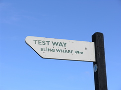
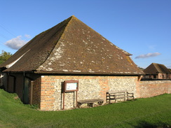
I was unsure where the Test Way actually ends; the country council website says that it ends at Inkpen Hill, but a more recent site stated that it ended a little further to the east. I joined the track and turned right for the walk to the end of the Way. The track initially climbed up to pass Combe Gibbet and a boggy stretch of track, before descending down to meet a road by a car park. Here there was a sign stating 'Test Way, Eling Wharf 49 miles', so I assume that this is the official end of of the Way. Fortunately this did not mean that I was now pathless, as the point also marks the start of the Wayfarers Walk, and I followed this uphill along a track that was soon passing the rather unimpressive circular bank of the Walbury Hillfort.
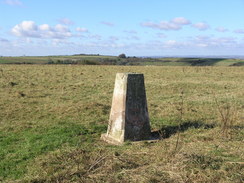
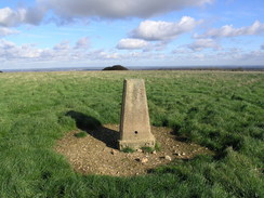
The trig pillar on top of the hill is a county top, and so although I had visited it about seven years ago I still wanted to revisit it. Last time I had been to the top there had been vehicles at the top (including a BBC vehicle retransmitting pictures from Newbury races), but now the track leading to the pillar was blocked and there were signs telling people to keep out as it was a wildlife conservation area. I wonder why farmers are being forced to open up land to the public, yet large tracts of land can be closed off because of wildlife. I ignored these signs and walked up to the pillar, took my photos and then headed back to rejoin the track. Walbury Hill is apparently the highest chalk point in southern England, a fact that I find slightly surprising.
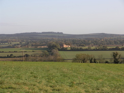
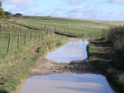
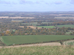
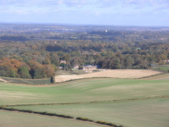
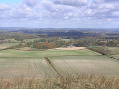
For the next few miles the views to the left were superb, the clear weather allowing me to certainly see the A4, and possible traffic on the M4 as well. I therefore spent much of the time as I walked looking over my shoulder as the Wayfarers Way followed a combination of tracks, paths and roads along the very top of the ridge. There was one point where the track was fully flooded, making it look more like a canal, and a local woman who was walking her dog told me that in winter the water levels can be far higher. Fortunately locals had made a diversion path slightly off to the left, and although narrow this made it easy to pass the stretch.
My next target was Pilot Hill, which is another county top, and one that again I had visited back in 2000. I climbed a gate and quickly headed up to the trig pillar at the top of the hill, which could not be seen from the track due to the curvature of the hill. By this time I fancies a rest, so I walked on until a road was reached, and then found a large log blocking a field entrance, and I sat down on this and admired the superb views over the plain to the north. It was a very pleasant spot to stop for a rest, and the adjacent hedges helped keep the worst of the wind off me as I studied the views and compared them to what I could see on the map.
Once I was ready to set off once again I put my rucksack on and suddenly saw something on the grass behind where I had been sitting - closer inspection showed it to be two condom wrappers,and next to it was an obviously-used condom, gracefully not decomposing. It was a fairly disgusting but weirdly amusing sight, and the spot that I had stopped was obviously popular with others as well!
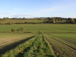
A road led on, after which a track led on southeastwards. This was a fairly ordinary stretch of path and the views were non-existent for much of the time, particularly when it was passing through the woodland. Another road is crossed, after which the Way followed a byway following the Ox Drove track. This was very rutted and boggy in places, so much so that I was forced to walk in the field to the left, seemingly as several others had done. It was a relief when the main road was reached, and here I decided to leave the route that U had planned to take and instead extend it slightly by continuing along the Wayfarers Way.
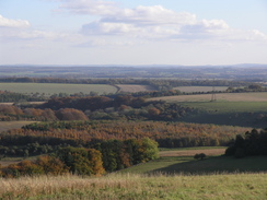
Some views came back, and to the left Highclere Castle could be seen down below. The way passed a curious circular building - perhaps something to do with the Highclere estate - at Grotton Copse, and after passing through another and of trees I was greeted with some pleasant views to the left as the path started heading towards the A34(T). It was another stretch of path that was pleasant to walk along, but soon I had to leave the path as another track headed down to meet a road at Lower Woodcott Farm. As I descended there was a distinctive sound in the air, and when I looked over my shoulder there was a Chinook helicopter flying around - the twin rotors of a Chinook give a different sound to those of normal helicopters.
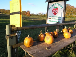
Unfortunately this marked nearly the last of the footpath walking for the day, and a road took me on towards Dunley, where a short stretch of path took me uphill . Another road took me on towards Egbury, where there is a section of banking marked on the map. The adjacent farm is called Egbury Castle, but it turns out that it is actually prehistoric banking. There was little else of note until the road reached St Mary Bourne, except for the fact that the sun was low in my eyes along one stretch of narrow road, and the remains of cobwebs glinted in the air in front of me as they were blown out from the hedge. There was a display of pumpkins for sale outside a pick-your-own farm, and I decided not to get one and instead walk on.
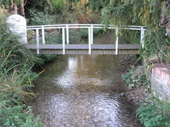
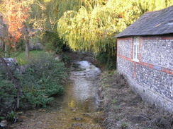
St Mary Bourne is a lovely little village, with a stream running through the middle of it alongside the main road. A building was under heavy restoration and was completely clad in scaffolding, and through the fabric lining it I could see that the entire first floor had been gutted, so it could be seen right through. Next there was a blacksmiths on the left, an unusual sight, and before I knew it I was back at my car, after what had been the best day's walk since I moved down to Romsey. Indeed, it is one that I could easily do again one day.
 |
 |
|
 |
 |
|
Directions
This walks starts off at the Coronation Inn in St Mary Bourne. Leave the pub and turn left up School Lane to meet the Test Way by some gates leading into Haven Hill. Turn right and walk along the lane, with the school on the right, and when the road curves to the left follow it as the road becomes slightly rougher underfoot. After a few yards turn right to cross a stile and take a footpath that turns behind houses, and just before a stile is reached ahead turn left to cross another stile and head diagonally uphill towards a stile in the upper-right hand corner of the field. Cross this stile, and walk through a small patch of woodland to reach a road.
Turn right along the road for a couple of yards and then turn left, to climb up some steps and cross a stile and follow the footpath along with a hedge on the right, slowly climbing. The path then turns to the right and immediately to the left to continue on with a hedge on the left as the views open out to the right. At the end of the field the path turns to the left to head through some trees, and then after a couple of yards turn right across a stile to walk along with a fence on the right and a hedge on the left. Continue straight on as the path crosses six stiles with the hedge remaining on the left; the last stile is beside a gate that leads out onto a road.
Turn right down this road for about ten yards and then turn to the left to walk up a surfaced lane. When this forks through the gateway into Stokehill Farm take the left-hand fork, and after about twenty-five yards take another right-hand fork that leads up to a gate. Go through the gate and turn right, to continue on along the right-hand side of the field. Keep the hedge to the right as it passes a little patch of trees until the corner of the field is reached, and then go through a clapper gate. In the next field keep the hedge to the right and continue on to another stile. On the other side follow the hedge for a short distance to another stile by a gate, and go through this to enter the woods on Wallop Hill Down.
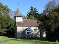
On the other side of the stile the path follows a track through the woods. When the track turns to the left the path plunges on through trees. When the tree cover becomes sparser take another footpath that leads off to the right, heading downhill steeply through the woods to cross a track before emerging out into an open field. Turn left and then immediately to the right to head straight down a track until this reaches the bottom of the slope, and then turn left to walk along another grassy track until a farm building is reached. Then turn right to walk down to Lower Farm. Walk past the farm and join a road that passes a school on the left to reach the B3048 Church Street in Hurstbourne Tarrant opposite the village church.
Turn left and follow the road westwards for a couple of hundred yards until a junction with the A343 road is reached, and then turn right to walk northeastwards along the road for about fifty yards. Just before the post office is reached the Test Way leads off to the left, and follow the path as it heads over a series of gates before entering a paddock with a small stream to the left. Continue on along the path through more clapper gates before reaching a stretch of path with fences on either side. Head down this path, and when it ends at a track turn left and soon after it curves to the right it ends at a road. Turn right and start following a road northwards with a large house on the right. The road soon curves to the left, and when it curves to the left once more turn right up a track that heads past a series of farm buildings.
Continue along this track as it continues to climb, When the track forks take the main track to the left, eventually passing a large barn on the right before passing under some electricity pylons. The track becomes more enclosed as it starts to heads northwestwards, passing under the electricity pylons once again to reach a junction of tracks. At this junction turn right to head northwards, passing under the pylons once more as it climbs uphill, before curving to the left to head northwestwards to end at a road. Turn right and follow this road as it heads northwards for a few hundred yards until it passes Manor Farm on the left to reach the little hamlet of Linkenholt.
At a road junction turn left and walk westwards to pass Linkenholt church, and when the road curves to the left take a path that heads off to the right along a surfaced drive. When this curves sharply to the left continue straight on along an unsurfaced track. When this enters a field continue straight on with a fence to the right. At the bottom of this field and enter some trees as the path plunges downhill before joining a track that emerges out from the trees with what looks like a house on the right. When this track ends at a junction with another track near the house, turn left and start following a track northwestwards along the bottom of the valley.
The track passes a little brick building on the right before entering trees and slowly becomes rougher as it heads on until it emerges from the woods at the intersection of several tracks. Here turn right and start following a path steeply uphill with the trees on the right;the gradient soon slackens and continue along this track northwards. At times the path follows a track and others it is a path; keep the hedges to the right, the left and then the right as the path slowly climbs before ending at a junction with another track on Inkpen Hill.
Turn right and follow this track as it heads eastwards, initially climbing up to pass Combe Gibbet before descending down to reach a road and, on the other side, a car park. This marks the end of the Test Way and the start of the Wayfarers Way. Keep the car park on the left as another track heads uphill, passing across the top of Walbury Hill before descending down to another road. Follow this road for a couple of hundred yards; at the next junction turn left along the road for a couple of yards before turning right down another track. This heads southeastwards, rising and falling as it heads along the edge of the ridge passing Pilot Hill
Continue on along the track as it continues southeastwards, eventually passing Charldown before descending to meet a road. Turn right and follow this road southeastwards for a few hundred yards and, shortly after a little patch of woodland on the left, turn left to join another track. Follow this track as it heads southeastwards past Bunghanger Copse, the trees ending before and the track continuing on before ending at a road after about a mile. Cross this road and continue straight on along another track, this one called Ox Drove, for a little under a mile until it ends at the A343 road. Turn left along the road for a few yards to a road junction on the right; turn right up this new road and then, when the road curves to the right, turn left to join another track. The track forks; take the right hand fork and pass a circular building on the left before slowly curving to the right and heading southwards towards Upper Woodcott Down.
When the track curves to the left continue straight on uphill across a field towards the corner of a patch of trees. Skirt this corner and then head diagonally across a field, as the path meets a fence on the right which it follows to a gate. At the point the Wayfarers Way is left; go through this and turn right up a track that slowly descends southwestwards under some power lines to meet a road at Lower Woodcott Farm. Turn left and follow this road southwards for a mile to Dunley; here it curves sharply to the right to climb uphill slightly for fifty yards, and when it curves to the left continue straight on along a footpath that heads up between hedges. This short footpath soon ends at another road next to Dunley Park on Bradley Hill; head straight on along another road that heads for a mile south toward Egbury Hill.
When this road ends at a T-junction turn left and then immediately to the right to start following another road southwestwards for about three-quarters of a mile until it ends at another junction. Turn left here and follow this new road south for a couple of hundred yards to a T-junction, and when this ends turn right to follow the road for about half a mile south westwards until it ends at a T-junction with the B3048 road in St Mary Bourne. Turn right and follow this road through the village; it immediately turns to the left and then the right and then the left to cross a stream. The walk ends at the Coronation Inn, at the northwestern end of the village.
 |
 |
|
 |
 |
|
Distances
| From | To | Distance (m) | Ascent (ft) | Descent (ft) |
|---|---|---|---|---|
| St Mary Bourne | Hurstbourne Tarrant | 3.6 | 440 | 371 |
| Hurstbourne Tarrant | Walbury Hill | 8.7 | 1086 | 449 |
| Walbury Hill | Pilot Hill | 2.1 | 190 | 226 |
| Pilot Hill | Lower Woodcott Down | 4.9 | 272 | 604 |
| Lower Woodcott Down | St Mary Bourne | 4.8 | 138 | 476 |
This makes a total distance of 24.1 miles, with 2126 feet of ascent and 2126 feet of descent.
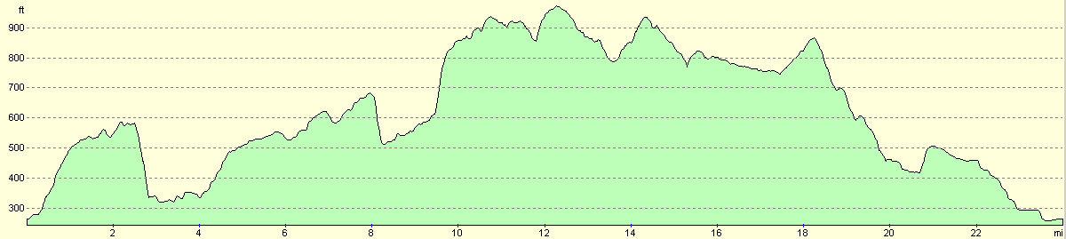
For more information on profiles, ascents and descents, see this page
 |
 |
|
 |
 |
|
 |
 |
|
 |
 |
|
Disclaimer
Please note that I take no responsibility for anything that may happen when following these directions. If you intend to follow this route, then please use the relevant maps and check the route out before you go out. As always when walking, use common sense and you should be fine.
If you find any information on any of these routes that is inaccurate, or you wish to add anything, then please email me.
All images on this site are © of the author. Any reproduction, retransmissions, or republication of all or part of any document found on this site is expressly prohibited, unless the author has explicitly granted its prior written consent to so reproduce, retransmit, or republish the material. All other rights reserved.
Although this site includes links providing convenient direct access to other Internet sites, I do not endorse, approve, certify or make warranties or representations as to the accuracy of the information on these sites.
And finally, enjoy your walking!
Nearby walks
| # | Title | Walk length (miles) |
|---|---|---|
| 74 | Wooton Rivers to Kintbury | 16.4 |
| 75 | Kintbury to Newbury | 9.3 |
| 99 | Newbury to Reading | 19.6 |
|
|

|