Walk #464: Carrick Castle to Dunoon
 |
 |
|
General Data
| Date Walked | 06/06/2003 |
| County | Strathclyde |
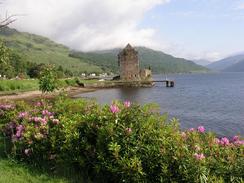
| Start Location | Carrick Castle |
| End Location | Dunoon |
| Start time | 08.30 |
| End time | 16.34 |
| Distance | 19.6 miles |
| Description | This was a long plod down the western side of Loch Long and around Holy Loch. |
| Pack | Today I carried my 30-litre Karrimor HotRock rucksack, which was filled with my packed lunch, waterproof leggings, water bottle and a couple of spare shirts, together with the usual assortment of odds and ends. |
| Condition | The underside of my feet ached terribly during much of this walk, and this proved to be the limiting factor in how far I could walk. Aside from this I had no other problems, but that was bad enough. |
| Weather | When I got up first thing this morning it was quite warm, and although there was a light shower before I set off it was fortunately dry throughout my walk. It was quite a warm day, and although there some cloud it was sunny for long periods. |
| OS map | Landranger number 56 (Loch Lomond & Inveraray) and Landranger number 63 (Firth Of Clyde area) |
 |
 |
|
 |
 |
|
Map of the walk
Maps courtesy of Google Maps. Route for indicative purposes only, and may have been plotted after the walk. Please let me have comments on what you think of this new format. For a detailed table of timings for this walk, please see the table file.
 |
 |
|
Notes
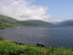
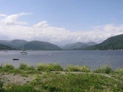
Another day, another loch, this time Holy Loch. Going up and down all these lochs should in all rights be quite depressing - I am covering vast mileages just to get a few miles as the crow flies. The scenery, however, prevents this - I am seeing some absolutely superb Highland scenery, and this more than makes up for the fact that I am making slow progress. Whenever I get fed up I can look up and see some lovely scenery or grand mountains, and I realise that if I was not doing this route I would not be able to see all these wonderful sights. Indeed, sometimes I find it is nice to stop mid-stride, look out over some or other loch, and just breathe in the beauty.
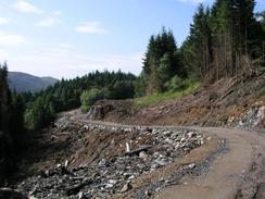
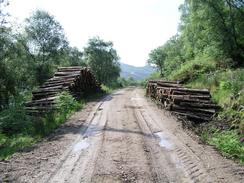
The first part of the day follows a path that is marked on the map down the western side of Loch Long. The path is well marked on the map, but unfortunately on the ground it was not exceedingly distinct. The first part was easy enough to follow, but unfortunately it crossed a couple of streams that were in spate, and in one of these my bots got unavoidably filled with water. The ground around these was quite boggy, and this did not help y feet much at all. After a while I lost the path totally, and so I decided to walk through the woodland, keeping as low as possible towards the shoreline. I made very slow progress over this section of path as a result of all the vegetation, and about halfway along I discovered a strange structure comprising driftwood and plastic sheeting in amongst the trees. I called out to see if anyone is around, but there was no answer, although the fire was still warm. I can only assume that whomever lives there get in by boat, as there were absolutely no tracks in. It was quite spooky in a way, and I imagine what sort of person could live there. Eventually I could see the power lines heading through the forest, and I knew that the end of the track was directly above that. I found the track, and from there it was a gentle stroll down into Ardentinny.
By the time that I reached Kimun, on the northern bank of Holy Loch, my feet wee really aching, and so I decided to have a break and to nip into the hotel cum pub in the village for a drink. When I sat down in the bar I got my Psion out and started to write some notes up for a couple of previous days. I am not up to date with these, which will ease my task next time I have to update the website. I had a chat with the landlady as I did this, and I found it quite hard to understand her strong Scottish accent. My feet ached less due to the rst, but it did not take long once I restarted for them to start aching again, which rather dented my mood.
My feet really suffered today, and by the end of the walk they were aching more than they have done for many weeks. This was a result of getting my feet wet so early on in the walk, and the underside of my left foot has suffered particularly badly. I was quite keen to continue on for another few miles to reduce the distance that I have to do tomorrow, but once I reached Mervan, which was parked on the promenade, I really did not want to walk any further. I took my boots and socks off and the underside of my feet looked absolutely terrible, as if they had been boiled for a couple of hours. As soon as I took my boots of I got pins and needles in my feet, and this lasted for about twenty minutes before the circulation finally re-established itself.
I had been expecting to see American submarines in Holy Loch, as I was aware that it was their Scottish submarine base. Unfortunately I was to be disappointed, as it turns out that the Polaris submarines left in 1991 after 30 years based in the Highlands. Over 4,000 Americans lived by Holy Loch at one stage, and their houses are still present on the southern side of the loch at Sandhaven. The loss of the base has cost the local economy a great deal, and apparently it is still suffering. As I walked around the loch I could not see any trace of buildings, which surprised me as the British submarine bases have large buildings in the adjacent Loch Long. When we went into the Tourist Information office in Dunoon I enquired about this, and it turns out that the base was a massive floating dry dock that had been moored in the middle of the loch. When the base was closed, they simply towed it away!
I had walked hard over the last couple of weeks to reach Dunoon for today, as we had some friends from the scuba diving club coming to visit. This evening we went out for a sumptuous meal with them at their hotel, and it was great to be able to catch up with everything that is happening back in Cambridge. The hotel that they are staying in is absolutely beautiful, and the wine list was in place expensive (of course we had the cheapest carafe that they had!). It was a truly lovely evening with some great company, and it reminded me of exactly what I am missing by doing this walk.
Directions
This walk starts off at the car park opposite Carrick Castle. Turn right and head southwards along the road past the old hotel and onwards, as the road ends and a track continues on to the house at Ardnahein. A path skirts around the house, and continues southeastwards along some boggy ground past Toll nam Muc. When the flat land ends the path turns to head southwards; I found the path to be extremely indistinct on the ground, so I chose to make my own way to the headland of Rubha nan Eoin, and then southwards for another kilometre. I chose to keep as low down as possible, until I neared some power lines when I climbed uphill to meet a forestry track.
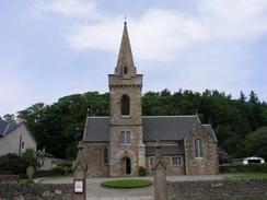
Turn to the left and follow the forestry track southwards as it slowly descends towards Stronvochlan. When the track reaches a car park take a path that follows the shoreline around Finart Bay before reaching a road on the northern outskirts of Ardentinny. Follow this road southwards through the village, and then onwards down the cost past Gairletter Point towards Blairmore, where the road becomes the A880. Continue on to Strone Point, where the road curves around to the right to head northwestwards through Kilmun along the northern bank of Holy Loch. Just before the junction with the A815 is reached a path leads down on the left, which leads over an old bridge over the River Eachaig and on past a pub before joining the A815 road.
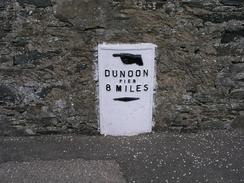
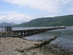
Turn left and follow the A815 road as it swings around the end of Holy Loch and turns to head southeastwards through Sandbanks on the southern side of the loch. When the junction with the A885 is reached turn left to continue along the A815 road as it skirts the coast eastwards to Lazaretto Point, where it turns to head southeastwards to the pier at Hunter's Quay. From here the road turns to head southwards towards the centre of Dunoon. This walk ends about a hundred yards up the road from the pier in the town, just before the tourist information office is reached.
Distances
| From | To | Distance (m) | Ascent (ft) | Descent (ft) |
|---|---|---|---|---|
| Carrick Castle | Ardentinny | 6.0 | 1437 | 1440 |
| Ardentinny | Kilmun | 6.3 | 417 | 397 |
| Kilmun | Dunoon | 7.3 | 420 | 443 |
This makes a total distance of 19.6 miles, with 2274 feet of ascent and 2280 feet of descent.
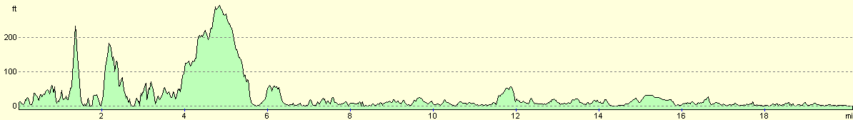
For more information on profiles, ascents and descents, see this page
Accommodation
We parked Mervan in a car park by West Bay, which was handy for the hotel in which our friends were staying in.
Disclaimer
Please note that I take no responsibility for anything that may happen when following these directions. If you intend to follow this route, then please use the relevant maps and check the route out before you go out. As always when walking, use common sense and you should be fine.
If you find any information on any of these routes that is inaccurate, or you wish to add anything, then please email me.
All images on this site are © of the author. Any reproduction, retransmissions, or republication of all or part of any document found on this site is expressly prohibited, unless the author has explicitly granted its prior written consent to so reproduce, retransmit, or republish the material. All other rights reserved.
Although this site includes links providing convenient direct access to other Internet sites, I do not endorse, approve, certify or make warranties or representations as to the accuracy of the information on these sites.
And finally, enjoy your walking!
This walk was mentioned in the following routes:
| My walk around the coastline of Britain |
Nearby walks
| # | Title | Walk length (miles) |
|---|---|---|
| 459 | Fairlie to Fort Matilda | 19.1 |
| 460 | Fort Matilda to Dalreach | 21.1 |
| 461 | Dalreach to Rosneath | 22.2 |
|
|

|