Walk #356: Boscastle to Crooklets
 |
 |
|
General Data
| Date Walked | 14/02/2003 |
| County | Cornwall |
| Start Location | Boscastle |
| End Location | Crooklets |
| Start time | 08.25 |
| End time | 16.14 |
| Distance | 17.4 miles |
| Description | This was a lovely albeit very strenuous walk, and it was well worth all of the effort going up and down all the hills.. |
| Pack | Today I carried my 30-litre Karrimor HotRock rucksack, which was filled with my packed lunch, waterproof leggings, water bottle and a couple of spare shirts, together with the usual assortment of odds and ends. |
| Condition | The biggest problem that I had today was with both of my knees, which ached considerably at times on the steps leading up and down some of the steep ascents and descents. This was annoying more than worrying, and I shall see how it goes tomorrow, and hopefully I will have no further problems. Yet again I had no real problems with my ankle, for which I am thankful. |
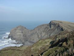
| Weather | Today started off quite clear and quite cold, with another frost on the ground in sheltered places. It clouded over at times, but this cloud never threatened any rain. It never really warmed up much from the early cold, and there was a bitterly cold easterly wind to make things worse. There was also a general haze in the sky and this meant that I could not get any really good long distance views along the cliffs. |
| OS map | Landranger number 190 (Bude, Clovelly & surrounding area) |
 |
 |
|
 |
 |
|
Map of the walk
Maps courtesy of Google Maps. Route for indicative purposes only, and may have been plotted after the walk. Please let me have comments on what you think of this new format. For a detailed table of timings for this walk, please see the table file.
 |
 |
|
Notes
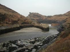
I found this walk to be much harder than I was expecting it to be, particularly when compared with yesterday's walk, which was meant to be harder than this one. Some of the ascents were very steep, and in particular there was one valley side that had steps all the way up it. I found this climb quite hard, and I even had to stop halfway up for a minute so that I could have a short rest before continuing to the top. I have not had to do this on any ascents for some time, so it just marks how hard this walk was.
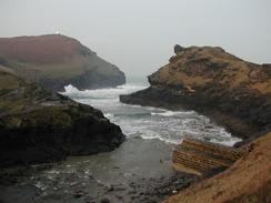
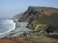
The geology on this walk was very impressive in places, with the different layers of slate folded into large S-shapes that were highly visible from above and below. Near Compass Point to the south of Bude there is a large flat piece of slate sticking vertically out of the cliff; a massively impressive sight. The forces needed to not only metamorphose the sedimentary rocks into slate, but also to bend them into these strange and weird shapes, are really beyond comprehension. There was also some very visible discontinuities; places where older, folder rocks have been eroded flat and other rocks deposited above them. These discontinuities give a very spectacular impression, especially when the compositions of the two layers of rock are very different. In many place today I was walking along just such a discontinuity, and it was very easy to make out the different layers of rock.
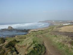
I was very glad to reach Widemouth Bay, as I knew that the bay marked the start of a much easier and less strenuous walk. Although there are still cliffs, they are invariably lower than those that came earlier in the day and the ascents and descents were thankfully very gradual. I stopped at the bay so that I could eat my lunch, and I watched fascinated as surfers launched themselves off the beach and into the large, rolling waves. Unfortunately the view was very much spoilt by the litter that absolutely covered the beach, and much of this looked absolutely disgusting. It was the worst litter pollution that I have seen since the Torquay area in South Devon, and it was a very sad sight.
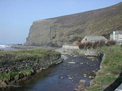
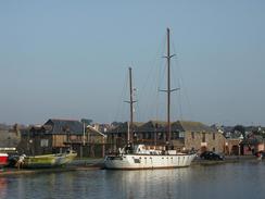
When I got to Bude I walked along the remnant of the delightful canal, with its tidal lock still complete. Sam had parked the van in a car park in Crooklets, which is just under a mile north of the town, and so I had to walk around the sea front, which was an extremely nice, if cold, walk. Bude is a very nice town and well worth visiting, but this afternoon my main focus was to get back to the van so I could warm myself up.
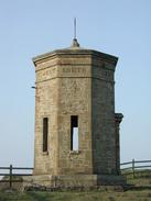
As I was walking along today I lost Radio Four on my walkman, so I started to retune it. You can imagine my surprise when the tuner suddenly locked onto a station broadcasting in a Gaelic language. This very much surprised me, but a few minutes later I also heard BBC Wales, so I am obviously near enough Wales now to get their radio stations! This became less surprising when I reached Compass Point to the south of Bude, where there was a dial with the directions and distances to various places on it, and I was amazed to discover that Swansea is now nearer than Land's End! Also on Compass Point there is a lovely octagonal building that was used as a lookout post for ships entering the harbour at Bude. On each side of the building are the four cardinal compass points and the four points in between, and this makes for a fascinating and interesting little structure.
Tomorrow promises to be an exceedingly hard day's walk, and although it will only be about fifteen miles it has a number of steep descents and ascents to be made before I reach Hartland Quay. It is hard to know exactly how hard I will find any particular walk, but several people I have met refer to tomorrow's walk to be by far the hardest on the entire South West Coast Path. Despite these slightly ominous warnings I am very much looking forward to the walk, although I shall be glad when it is over. As this trip is going on all thoughts of not actually finishing the walk and not getting back to Edinburgh have disappeared, and I am now more confident than I have been at any time on this walk. I can only hope that this is not over confidence, but it is just the way I feel at the current time.
Directions
| During this walk I followed the South West Coast Path, the route of which is detailed in the Ordnance Survey National Trail Guide 8, Minehead to Padstow (ISBN 1-85410-774-7). Unfortunately the route description is written in reverse to the direction that I am walking, but the 1:25,000 maps in the book are clear and the signs on the ground are very good. Also to be recommended is the South West Coast Path Association guidebook (ISBN 0-907055-04-4), which has less concise directions and no maps, but includes accommodation details and grades each section of the walk according to difficulty. They also publish reverse directions, which are suitable for walking in the direction that I walked the route. They have a website at www.swcp.org.uk, which is well worth a visit. | 
|
| 
| |
| |
| |
Distances
| From | To | Distance (m) | Ascent (ft) | Descent (ft) |
|---|---|---|---|---|
| Boscastle | Crackington Haven | 6.9 | 2382 | 2316 |
| Crackington Haven | Bude | 9.5 | 2723 | 2805 |
| Bude | Crooklets | 1.0 | 121 | 102 |
This makes a total distance of 17.4 miles, with 5226 feet of ascent and 5223 feet of descent.
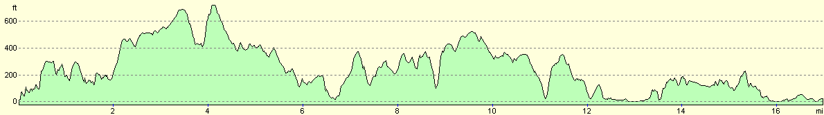
For more information on profiles, ascents and descents, see this page
Accommodation
We parked in the car park beside the beach at Crooklets, which rather handily had some public toilets beside them.
Disclaimer
Please note that I take no responsibility for anything that may happen when following these directions. If you intend to follow this route, then please use the relevant maps and check the route out before you go out. As always when walking, use common sense and you should be fine.
If you find any information on any of these routes that is inaccurate, or you wish to add anything, then please email me.
All images on this site are © of the author. Any reproduction, retransmissions, or republication of all or part of any document found on this site is expressly prohibited, unless the author has explicitly granted its prior written consent to so reproduce, retransmit, or republish the material. All other rights reserved.
Although this site includes links providing convenient direct access to other Internet sites, I do not endorse, approve, certify or make warranties or representations as to the accuracy of the information on these sites.
And finally, enjoy your walking!
This walk was mentioned in the following routes:
| My walk around the coastline of Britain |
| South West Coast Path |
Nearby walks
| # | Title | Walk length (miles) |
|---|---|---|
| 83 | Port Isaac to Boscastle | 13.5 |
| 84 | Boscastle to Bude | 15.2 |
| 85 | Bude to Elmscott | 13.8 |
|
|

|