Walk #355: Port Isaac to Boscastle
 |
 |
|
General Data
| Date Walked | 13/02/2003 |
| County | Cornwall |
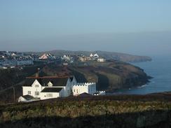
| Start Location | Port Isaac |
| End Location | Boscastle |
| Start time | 08.19 |
| End time | 15.04 |
| Distance | 13.0 miles |
| Description | This was a short but fairly strenuous day, with many steep ascents and descents on the stretch from Port Gaverne to Tintagel. |
| Pack | Today I carried my 30-litre Karrimor HotRock rucksack, which was filled with my packed lunch, waterproof leggings, water bottle and a couple of spare shirts, together with the usual assortment of odds and ends. |
| Condition | I feel absolutely fine after this walk, and I could easily have walked further if there had been a convenient place for me to be picked up. I have no problems to report, and my ankle did not ache at all during the day. |
| Weather | The weather today was just perfect for walking, with the morning having bright sunshine and the afternoon having some cloudy periods. Initially it was exceedingly cold, with probably the heaviest frost I have seen so far on the walk. All in all it was another lovely day for walking. |
| OS map | Landranger number 200 (Newquay & Bodmin, Camelford & St Austell) and Landranger number 190 (Bude, Clovelly & surrounding area) |
 |
 |
|
 |
 |
|
Map of the walk
Maps courtesy of Google Maps. Route for indicative purposes only, and may have been plotted after the walk. Please let me have comments on what you think of this new format. For a detailed table of timings for this walk, please see the table file.
 |
 |
|
Notes
I thoroughly enjoyed today's walk, and I wish that every day could have weather as nice as it was during today. As I walked today I listened to the fourth tape in Simon Schama's History of Britain, and as I went up and down the hills my mind wandered over the historic lives of Henry the Eighth and Elizabeth the First. Although I knew some details about their lives it was really nice to put these facts into context - in particular the history of the reformation of the church and the break with Rome. I am slightly ashamed that I did not already know the details of what occurred, and had relied on half-remembered snippets of factlets that I had learnt over the years.
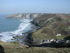
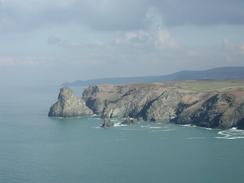
The first stretch if this walk as far as Tintagel is rated as severe, and I can well see why. The path plunges up and down many times along the course of the walk, up and down some very steep hillsides. In a couple of places early on the footpath went straight up these hillsides, and the path was scattered with small pieces of slates that made it very slippy - I had to use both poles to steady myself as I made my way up the hills. All the effort was well rewarded with some spectacular views along the cliffs, although I did not really stop for long enough to really admire them. The National Trail guidebook recommends that it will take five hours to walk from Trebawith Strand to Port Isaac, and so I am quite pleased that I managed this stretch in a little over three hours.
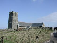
I stopped off to have a quick look around the church at Tintagel, which is a very nice building and (in my opinion) is far better to look around than the nearby castle, of which very little remains. I find it amazing that the castle is still being linked with King Arthur, despite several facts. For one thing it is very doubtful whether King Arthur ever existed (he is amalgam of various legends from several countries), and the castle was built in Norman times, centuries after King Arthur is meant to have ruled! It is the same sort of people who go to Nottingham Castle to see where Robin Hood (very probably another fictional character) fought and lived; despite the fact the present 'castle' is a relatively modern building, built on the site of the old castle.
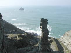
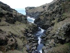
Between Trebarwith Strand and Tintagel there are the remains of old slate quarries that had eaten away into the cliff face and some of these were quite spectacular. In particular the Lanterden Quarry had a very spectacular rock pillar as high as the cliffs from the floor of the quarry; this pillar was an outcrop of poor quality slate that was not worth mining. The pillar is so thin and tall I am amazed that it has remained standing for such a long time - it looks as though it could fall over at any time. The whole area is full of reminders of the slate mining, from adits (both for drainage and transport) and the remains of old buildings. Most of these traces were being reclaimed by nature, leaving the quarries themselves as the most obvious traces of the effects of man.
I sat down with Sam and ate my sandwiches on a little hillock overlooking the remains of the castle, and in the sunshine this was a very nice little break. I have a fairly vivid imagination, and as I looked over the ruins I tried to imagine King Arthur riding up to it on his horse but I sadly failed - my natural scepticism about the origins of the story got the better of me. It was a nice spot to stay in the sun, however, and the rest allowed me to regain my energy before setting off on the next stretch of the walk.
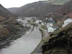
I really wanted to walk further than Boscasle today, as at thirteen miles I had not walked very far. However when I looked on the map there was nowhere really convenient for Sam to pick me up before I got to Crackington Haven - another seven miles further on. I therefore reluctantly decided to stop the walk early in Boscastle. Tomorrows walk promises to be quite a strenuous sixteen-mile hike, although I am gaining more and more confidence in being able to cope with the strenuous day, particularly after today when I walked the first stretch of this walk so easily. Tomorrow is also my penultimate day in Cornwall, as the day after I cross the border back into Devon.
Directions
| During this walk I followed the South West Coast Path, the route of which is detailed in the Ordnance Survey National Trail Guide 8, Minehead to Padstow (ISBN 1-85410-774-7). Unfortunately the route description is written in reverse to the direction that I am walking, but the 1:25,000 maps in the book are clear and the signs on the ground are very good. Also to be recommended is the South West Coast Path Association guidebook (ISBN 0-907055-04-4), which has less concise directions and no maps, but includes accommodation details and grades each section of the walk according to difficulty. They also publish reverse directions, which are suitable for walking in the direction that I walked the route. They have a website at www.swcp.org.uk, which is well worth a visit. | 
|
| 
| |
| |
| |
Distances
| From | To | Distance (m) | Ascent (ft) | Descent (ft) |
|---|---|---|---|---|
| Port Isaac | Tintagel Harbour | 8.4 | 2720 | 2618 |
| Tintagel Harbour | Boscastle | 4.6 | 1450 | 1562 |
This makes a total distance of 13.0 miles, with 4170 feet of ascent and 4180 feet of descent.
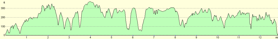
For more information on profiles, ascents and descents, see this page
Accommodation
We stayed at a large car park in the centre of Boscastle, which yet again had a sign proclaiming that there no overnight parking is permitted, and yet again we decided to totally ignore the sign! The car park is exceedingly handy for the local shops and pubs and is a very shore distance from the South West Coast Path and the harbour.
Disclaimer
Please note that I take no responsibility for anything that may happen when following these directions. If you intend to follow this route, then please use the relevant maps and check the route out before you go out. As always when walking, use common sense and you should be fine.
If you find any information on any of these routes that is inaccurate, or you wish to add anything, then please email me.
All images on this site are © of the author. Any reproduction, retransmissions, or republication of all or part of any document found on this site is expressly prohibited, unless the author has explicitly granted its prior written consent to so reproduce, retransmit, or republish the material. All other rights reserved.
Although this site includes links providing convenient direct access to other Internet sites, I do not endorse, approve, certify or make warranties or representations as to the accuracy of the information on these sites.
And finally, enjoy your walking!
This walk was mentioned in the following routes:
| My walk around the coastline of Britain |
| South West Coast Path |
Nearby walks
| # | Title | Walk length (miles) |
|---|---|---|
| 81 | Newquay to Padstow | 14.5 |
| 82 | Padstow to Port Isaac | 11.1 |
| 83 | Port Isaac to Boscastle | 13.5 |
|
|

|