Walk #695: Hertford to Harpenden
 |
 |
|
General Data
| Date Walked | 12/11/2005 |
| County | Hertfordshire |
| Start Location | Hertford East station |
| End Location | Harpenden station |
| Start time | 08.55 |
| End time | 15.10 |
| Distance | 18.3 miles |
| Description | This was a quite varied walk, right through the heart of Hertfordshire, mainly along footpaths and bridleways. |
| Pack | Today I carried my 30-litre Karrimor rucksack filled with my waterproofs, a book and various other odds and ends. |
| Condition | My right knee ached fairly continuously throughout the day, and I have not recovered from the sore throat that I had at the end of this week. Despite these I felt okay throughout the walk, and could easily have extended the walk if I had needed to. |
| Weather | The weather today was sunny with only occasional clouds; it was a colder day than I have been used to recently (it has been very mild this Autumn), but there was no breeze and this made it a superb day for walking. |
| OS map | Landranger number 166 (Luton & Hertford, Hitchin & St Albans) |
 |
 |
|
 |
 |
|
Map of the walk
Maps courtesy of Google Maps. Route for indicative purposes only, and may have been plotted after the walk. Please let me have comments on what you think of this new format. For a detailed table of timings for this walk, please see the table file.
 |
 |
|
 |
Notes
For some time I had noticed a large gap in the map of walks that I have done in Hertfordshire, and it has been obvious how to fill it, as the Lea Valley Walk heads all the way from Hertford to Harpenden, hence linking up two previous walks. Unfortunately transport back looked to be a problem (I would have to go via central London), and so this walk went onto the back-burner to a certain extent. However as I was looking for a local walk to do this weekend, I resolved to complete this walk once and for all. The drive from Cambridge to Hertford went fairly well, although I arrived later than I had been expecting due to the fact that I could not find anywhere to park.
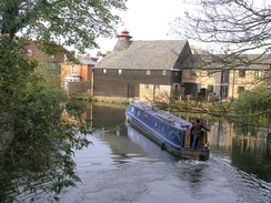
Eventually I pulled up outside Hertford East station, which I had walked near to on a previous walk, got my kit on and headed off. I nipped into the station to get train times back to the station from London, and was annoyed to find that they were being replaced by busses today. This made me resolve to catch a train to Hertford North station, about a mile away, and walk back to me car from there. Putting this to the back of my mind I set off, heading past a construction site to the River Lea. Hertford marks the end of the Lea Navigation, and as I walked along a canal boat was heading towards the basin at the end of the canalised section of river.
I diverted off towards the town centre, and passed a series of market stalls that were busy setting up for what looked like a nice, sunny day. Roads led me past a war memorial bedecked with wreaths before tomorrow's remembrance Sunday and on towards the castle. I had not been expecting to find a castle in Hertford, and although little of it remained, there were some walls and the whole area had been landscaped into some very pleasant gardens. I walked on, heading under the busy A414 on an underpass before heading for West Street, which headed westwards out of the town. A little bridge took me over the River Lea once more, which was much narrower than it had been in the centre of town, and on to the start of a trail.
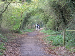
This trail followed the course of the old Hertford to Welwyn Garden City railway line, and it gave me a very easy walk as I headed westwards along it. It was an enjoyable stroll, and although the surrounding trees did not really allow me to see the best of the views, the views that were available were enough to console me. I passed the platforms of an old station at Letty Green, and headed on until the path headed under the A414. Here the Lea Valley Walk heads off to the left, and I walked alongside the main road for a short distance before heading back eastwards along a track. A fallen tree initially blocked my way, but this proved easy to climb over.
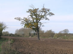
On the map the Lea Valley Walk headed south past Holwell Court, and although I thought that I found the path on the ground it soon petered out in a field. The hedge was pushing me into a more southeasterly course, and once I had jumped across a deep drainage ditch I eventually managed to find a road to the south of Letty Green, a fair distance from where I should have been. Annoyed, I walked along the road, which led down to the B158 road, and then back onto the Lea Valley Walk. The next stretch of this path was exceedingly boggy, and my trouser legs were soon covered in mud as I passed some people who looked like hunt supporters, although I saw no sign of any horses or hounds.
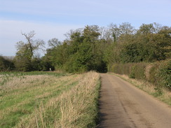
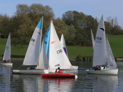
The path eventually became less muddy, although I was glad when I reached a track and a bridge that led over the River Lea once again - and this time it was even narrower, which left me wondering how long before it was just a trickle. The track led me up to the A414, and I crossed this before following a cycle path westwards along it, and then diverted off up the A1000. I soon found myself at Stanborough Lakes, an series of lakes, the largest of which was filled with sailing boats. These looked beautiful in the sunshine, and I took lots of photographs of them as I walked past. It was a wonderful stretch of walk, and I enjoyed it immensely until it ended at a car park near a boathouse and shop complex. Immediately beyond this I had to crouch to pass under a low bridge that carried a main road overhead, and some more lakes awaited me on the other side.
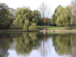
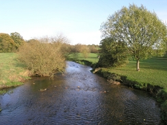
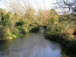
The next bridge I came to was another low one under the A1(M), and on the other side the Lea Valley Walk left the river to head across fields to Lemsford and then on towards Brocket Hall. Here the path ran through the middle of a large golf course, and the hall itself looked resplendent in the fine setting. It was an enjoyable stretch of path, made more so when the path dived through a wooded area before meeting the banks of the river once more. The path continued onwards, roughly paralleling the river as it heads westwards, and I got some pretty views along the river, with the water glinting in the sunshine.
It was a nice surprise to find myself in Wheathampstead, which turned out to be a pretty little village. The path headed along a road towards the church, and on the way I passed a little bakery, where I bought a large Eccles cake, and I scoffed this as I headed out of the village and onto a path that headed westwards high above the river. There were some good views to be had from here, and I enjoyed these as I finished the last of the Eccles cake and, before I knew it, I was descending down another path to meet a road at Leasey Bridge.
From here the Lea Valley Walk follows the course of an old railway line, and this was enjoyable enough until it neared a sewage works, where the small got slightly overpowering. I was relieved when the path left the trackbed shortly afterwards and joined the adjacent riverbank once more. Urban Harpenden encroached in on me as I walked, and although there were some nice stretches of river the surrounding urban areas were not hidden away. Once I reached Batford church I left the Lea Valley Walk and started walking down a road towards Harpenden railway station; on the way I crossed a bridge over the old railway track, which led me to wonder why I had not followed that all the way, which would have saved me half a mile or so.
When I got to the station, I fond the automatic ticket machine in Platform 1 (the one nearest to the car park that I entered) was out of order. I therefore crossed the footbridge and queued at the ticket office to buy a ticket, I was shocked, but not too surprised, to find that the ticket cost me £17.80; apparently going into London means that it costs much more. As soon as I bought the ticket I looked up at the timetable screen to see that a fast train to London was due immediately; I looked out and could see it standing at Platform 1. I started going over the footbridge, but as I was halfway across the train pulled out. Once on the platform I discovered a slow train was due in ten minutes, so I sat down and listened to my Walkman whilst I waited.
The slow train got me to Kings Cross Thameslink, and once I walked to Kings Cross itself I discovered that a train for Hertford North was due to leave soon. I yomped to platform 11, and got on the train a few minutes before it left. The journey back north was enjoyable, although initially crowded, and I got a beautiful sight of the sun sinking under a red sky below Alexandra Palace. I found myself feeling very, very good - indeed, better than I had after a walk for some time - although as my knee was aching this was a purely mental effect. When the train terminated at Hatfield North I got out, put my head torch on and started walking back to my car at Hertford East station. It was a walk of about a mile, but I found myself walking through the town centre, with market stalls packing up all around me, at quite a fast rate, metaphorically floating through on a cloud of euphoria that surrounded me.
Directions
This walk starts off at Hertford East railway station. Leave the station and turn right out of the main entrance, to head northwards. This road soon ends at the River Lea; cross the river using the bridge and then turn left to descend down to the path that runs along the northern bank. Initially a long bridge takes the path over a spillway, but it soon emerges onto dry land and continues westwards towards the centre of the town. Shortly after The Old Barge pub is reached on the right a bridge is reached; climb onto this bridge and turn left to walk south along a road.
Once the market place is reached turn right and walk westwards, and when war memorial is reached walk through the Castle grounds to reach an underpass under the A414 road. On the other side head west down West Street, and shortly after this curves to the left turn right down another track, which crosses the River Lea as it heads westwards. A path heads under an arch in a large railway viaduct, and this leads to an old railway path. Follow this path as it heads westwards for about three miles, passing through Letty Green until the A414 is reached. Do not pass under the underpass, but instead turn left to walk along the A414 southwards for about a hundred yards.
When a track leads off to the left at the end of some trees follow it as it heads eastwards, and after a short distance another path leads off to the right, heading south past Holwell Court to reach the A1455 road. It should be noted that I had great difficulty finding this path (see notes above), and so you may want to find a better route. Once at the B4155 turn left and follow it for a short distance as it crosses the River Lea once more before ending at a T-junction with the B158 road. Turn right to head eastwards for a few yards, and when the B158 turns sharply to the left continue straight on along a track that heads westwards along the southern bank of the river.
The track carries a bridleway that continues west for a little over two kilometres until it rejoins another track and reaches a bridge over the river. Cross this, and follow the track as it heads north for a few yards to end at the A414 road. Carefully cross the dual carriageway, and once on the other side turn left to walk westwards along the cycle path. After about a kilometre the cycle path veers off, and a path can be followed to reach the bridge that carries the A1000 over the A414. Climb up, and then turn right to follow the A1000 as it heads northwards towards the centre of Welwyn Garden City
The A1000 almost immediately crosses over the River Lea, and shortly after a road leads on from the right, turn left along a track that heads northwestwards towards Woodhall Farm. Continue along this track as it heads under a railway line, and on the other side it approaches a lake. Veer off across the grass to the left to meet the eastern ed of the lake, and then follow the path around the southern side of it. Once a boathouse and a car park is reached head under a main road on a low bridge and continue following the river northwestwards. After passing a couple more lakes it passes under he M1 on another low bridge, and her finally leaves the river to head northwestwards towards a road in Lemsford.
Once at the road turn right and follow the road for a short distance northeastwards as it crosses the river; once on the other side turn left and follow a path that heads northwestwards. The path rises up to cross a golf course before passing Brocket Hall, and then dives into some woodland before descending down to meet a road at Waterend. Cross the road, and once on the other side follow a footpath as it skirts the northern bank of the river westwards. The path crosses the B653 road before heading on along the northern bank of the river to enter Wheathampstead. At the main road in the village turn left to walk south; immediately after the church turn right along another road and then right once more, to head along a residential street. Before this road ends turn right up another road, and after a few yards take a footpath that leads off to the right.
This footpath heads westwards on the hillside to the south of the river, and a little over a kilometre later it reaches a track by a farm. Before the farm is reached turn right to follow a footpath that heads northwestwards downhill across a field, and when this ends at a road turn right along the road to reach Leasey Bridge. Do not cross the bridge, but instead turn left before nit to follow another path that follows the course of the old Harpenden to Welwyn railway line. The path passes a sewage works, and then, instead of following the railway trackbed, heads down some steps the right to reach a road that runs along the river bank.
Follow this road as it heads northwestwards, and when it shortly ends at a junction continue on along a path that heads in the same direction along the river bank. After about half a kilometre Batford Church is reached; where this walk leaves the Lea Valley Walk. Turn left to join a main road; this soon curves to the right to head southwestwards through Harpenden. Follow it for about a kilometre until Harpenden railway station, where this walk ends, appears on the left.
Distances
| From | To | Distance (m) | Ascent (ft) | Descent (ft) |
|---|---|---|---|---|
| Hertford East station | Stanborough | 10.0 | 535 | 453 |
| Stanborough | Wheathampstead | 4.6 | 269 | 207 |
| Wheathampstead | Harpenden station | 3.7 | 338 | 249 |
This makes a total distance of 18.3 miles, with 1142 feet of ascent and 909 feet of descent.

For more information on profiles, ascents and descents, see this page
Transport
I relied on a train journey from Harpenden to Kings Cross Thameslink, followed by a journey from Kings Cross to Hertford North. This cost me £17.80, which was exceedingly steep, and the journey took me a couple of hours, and was followed by a mile's walk back to Hertford East station.
Disclaimer
Please note that I take no responsibility for anything that may happen when following these directions. If you intend to follow this route, then please use the relevant maps and check the route out before you go out. As always when walking, use common sense and you should be fine.
If you find any information on any of these routes that is inaccurate, or you wish to add anything, then please email me.
All images on this site are © of the author. Any reproduction, retransmissions, or republication of all or part of any document found on this site is expressly prohibited, unless the author has explicitly granted its prior written consent to so reproduce, retransmit, or republish the material. All other rights reserved.
Although this site includes links providing convenient direct access to other Internet sites, I do not endorse, approve, certify or make warranties or representations as to the accuracy of the information on these sites.
And finally, enjoy your walking!
Nearby walks
| # | Title | Walk length (miles) |
|---|---|---|
| 52 | Enfield Lock to Harlow Town | 12.6 |
| 127 | Hitchin to Luton | 13.2 |
| 209 | Dunstable to Harpenden via Luton | 12.1 |
|
|

|