Walk #954: St Ives to Trumpington via the Busway
 |
 |
|
General Data
| Date Walked | 25/07/2012 |
| County | Cambridgeshire |
| Start Location | St Ives (Cambridgeshire) |
| End Location | Trumpington park and ride |
| Start time | 07.44 |
| End time | 14.31 |
| Distance | 18.0 miles |
| Description | This was a long and very easy walk following the Guided Busway from St Ives to Cambridge, and then on to its southern terminus at Trumpington. |
| Pack | Today I carried my 30-litre Karrimor rucksack, filled with water, my waterproofs, a book and other odds and ends. |
| Condition | I am rather hot and tired after this walk, which should have been easy. |
| Weather | Today's weather was far too hot and sunny for a long walk, and at times the heat was quite debilitating. |
| OS map | Landranger number 153 (Bedford & Huntingdon, St Neots & Biggleswade) and Landranger number 154 (Cambridge & Newmarket, Saffron Walden) |
 |
 |
|
Map of the walk
Maps courtesy of Google Maps. Route for indicative purposes only, and may have been plotted after the walk. Please let me have comments on what you think of this new format. For a detailed table of timings for this walk, please see the table file.
 |
 |
|
Notes
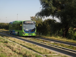
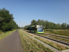
A month of fairly awful summer weather, floods and work on the house all conspired to prevent me from going for a walk - at least that is my excuse, and I am firmly sticking to it. However today's forecast was for hot and sunny weather, with temperatures hovering close to thirty degrees and so I decided to go for a stroll. For some time I had wanted to walk the route of the Cambridge Busway, a guided bus that opened at the end of last year. This follows the course of the old Cambridge to St Ives railway line, and proved to be both costly and rather controversial. Road buses are modified with the addition of little horizontal guide wheels that run along low concrete walls; this allows road buses to safely travel along the narrower old railway trackbed.
At the last minute I changed my plan to start the walk in St Ives rather than Trumpington, and to walk the route in reverse. The main reason for this was the hot weather; there were far more places and opportunities to bail out of the walk in the Cambridge area than around St Ives. The day started badly when the ticket machine in the car park chewed up my money, although this did lead me to having a rather pleasant conversation with the meter man.
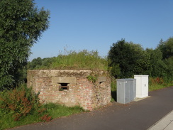
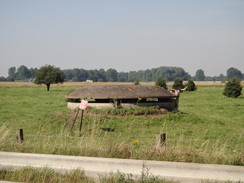
I nipped into the centre of St Ives to buy a few snacks and some extra water before heading off. The railway line used to fork in St Ives, with the man line heading north towards Somersham and March, whilst a branch line led towards Huntingdon. The former line has been obliterated in the town, and the main line to March was converted into a much-needed bypass. I crossed this to reach the course of the guided bus, soon passing a pillbox opposite the park and ride. I last walked here earlier in the year, but have good memories of a walk about ten years ago, when the railway line was still extant but disused. The guided bus had been a qualified success, but I cannot help but feel that reinstating the railway line would have been much preferable.
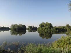
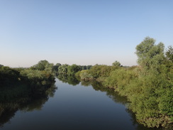
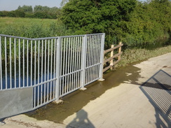
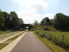
The busway crosses the Great Ouse on a high concrete viaduct that replaced the graceful brick railway viaduct that used to carry the railway line. Flooded gravel pits straddled both sides of the route, and the cycle path that ran alongside were low-lying in places, with the water standing very near to the path. Fortunately the barriers that close the path when it is flooded were open so I could progress on.
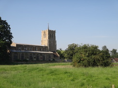
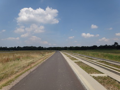
It was the hottest day's walking for some time, with the sun bearing down directly into my eyes. There was little to be done but to put my head down and walk. The steady flow of cyclists, walkers and joggers slowly reduced as we got past nine, although the path was undoubtedly well-used. My feet soon started to ache; I was wearing trainers rather than boots due to the tarmac surface underfoot, and this was proving to be a mistake. After three miles I passed Swavesey church, where I had joined the busway earlier in the year, and headed off into new territory.
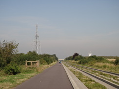
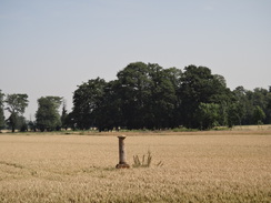
Soon a massive sculpture of skeletal steel hove into view - a BT communications mast. This rather overpowered the attractive windmill on the other side of the road, the two making a rather incongruous pairing. About a mile beyond this Longstanton Park and Ride was passed, with everything sparkling in the bright sunshine. MOD signs soon appeared on the other side of the Busway, along with occasional bunkers and low-roofed concrete pillboxes. This is the site of Oakington Airfield, which later on became a military barracks and more recently an immigration centre. This will soon be a new town, Northstowe, which will be very similar in vision to the village I live in, Cambourne. A spur road off the busway has been built ready to service Northstowe, but this was blocked off with a large bank of earth.
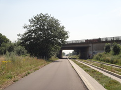
Whereas the area surrounding the Busway had been dominated by flooded gravel pits near St Ives, by Longstanton it had become more arable, and now, approaching Histon, it was increasingly industrial. A working factory dominated one side of the Busway, and a short further on were sad-looking derelict premises. I nipped into a shop in Histon to buy some water, my supplies having got rather low in the heat and also chose an ice cream which I scoffed as I strolled on towards the bridge that carries the A14 over the Busway. The lake on the other side of the Busway was busy with people enjoying the sunshine, and I wished I could be with them as well as I walked on. I had not mentally engaged with the walk and was finding the trip particularly hard in the heat.
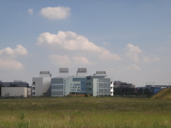
Soon the Busway passed a Regional College before continuing on past the Cambridge Science Park to reach Milton Road. The old railway line used to continue on to a junction with the Cambridge to Ely line at Chesterton junction, a couple of miles to the north of Cambridge station. The busses cannot use that stretch of line, which means that they have to drop off onto the congested Milton Road for the journey into the city centre. I joined the Milton Road as well, and was soon panting as the full force of the sun hit me.
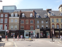
I knew the route into the city centre well, and I could not wait to reach the centre. People were enjoying the sunshine but I was feeling dead-beat as I walked past Midsummer Common towards the bus station. Soon I was heading towards the railway station, but as I passed the Regal pub I decided to nip in. When this opened in the late 1990s it was the largest pub in Britain, having taken over much of an old cinema. It is still a good place to stop for a drink, although it lacks some of the character of Cambridge's other pubs.
The first pint of bitter shandy disappeared before I had even left the bar, and I ordered a second before sitting down. A TV was tuned onto BBC News, and the subtitles told me that the GDP figures for the previous quarter had been horrible. I took my shoes off to allow my feet to cool down, and then slumped into a rather comfortable chair. I supped the second pint and relaxed whilst watching the world go by.
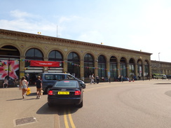
Eventually I had to set off once more, and I did so with more than a little reluctance. I knew the route to the railway station very well, and as usual the narrow pavements were crowded with pedestrians. Cambridge war memorial is situated on a small traffic island at the corner of Station Road, surrounded by busy roads. It is a terrible and unfitting place for a war memorial and as I walked past I was glad to see that it was no longer there. The statue was missing and a digger was breaking up the plinth. The statue is going to be erected a short distance away, and the bronze soldier will still be looking over his shoulder towards the station, waiting for his comrades who never made it home.
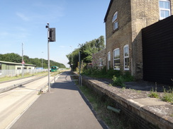
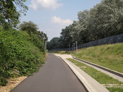
The southern leg of the Busway starts at the station, and the road network has been altered. The short-term spaces where I used to park whilst buying tickets at the station are now the bus stops, and a new road heads south. After passing under the Hills road bridge, the new Busway headed south parallel to the railway line, following the course of the old railway line to Bedford and Oxford. I had walked parts of this a few years before when there was still ballast on the ground, but the Busway had replaced everything.
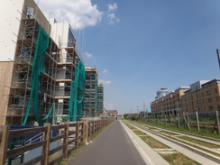
A new building at Addenbrookes Hospital became visible to the left, as did a new bridge that carries a branch of the Busway over the railway line. I passed a housing estate under construction, one of the many ways that the Busway and new roads in the area having opened up areas to development. By now I felt like a big, sweaty mess and was overheating; any liquid that entered my mouth seemed to come straight out of my pores. As a result, I decided to stop at the end of the Busway at the Trumpington park and ride rather than walk further south as I had planned.
The Busway became single-track for the last quarter-mile, the unidirectional stretch protected by simple traffic signals. After passing under a road bridge it climbed up to reach the park and ride site. I bought a ticket and collapsed down onto a seat, more than a little relieved at having finished a stroll on an overly hot day.
 |
 |
|
Directions
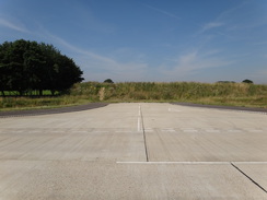
This walk starts off in the main car park near the bus station in St Ives at TL316712. Leave the car park and head south, passing a Waitrose store on the left to reach Station Road. Turn left to follow Station Road southeastwards to reach the A1096 road. Cross the road using the pedestrian crossing and head on along a cycle path, with a bus lane on the right. Before the park and ride is reached, cross the bus lanes using a pedestrian crossing to reach the southern side of the bus lanes near to a Second World War pillbox.
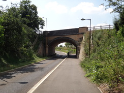
Turn left to start following a cycle path southeastwards alongside the Busway; it soon crosses the Great Ouse viaduct and continues on. Follow it as it heads though the countryside to the northeast of Cambridge; it swaps from one side of the Busway to the other occasionally, usually at roads crossings. It passes under a large bridge that carries the A14(T) overhead before ending at a junction with Milton Road in Cambridge at TL468612, 12 miles after the start of the walk.
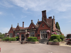
When Milton Road is reached, turn right and carefully cross the end of the Busway. Continue on southwestwards along Milton Road for a sixth of a mile until a crossroads with King's Hedges Road is reached beside the Golden Hind pub. Carefully cross the King's Hedges Road and continue on with Milton Road on the left. After another three-quarters of a mile a roundabout is reached at TL457600; cross this and continue along Milton Road. This heads on west-southwestwards before curving slightly to the right to take a more southwesterly course.
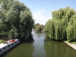
When the road splits at TL452595, turn left to cross a lane of the road to a little island, then right to reach the A1134 road, which is part of a large dumbbell-shaped traffic island. Carefully cross the road and follow a path past a building on the left to reach Chesterton Road on the other side of the traffic island. Turn left for a few yards, then turn right across a pedestrian crossing to a small island. Turn right here to reach Western Avenue. Follow Western Avenue south with the road on the left. It soon crosses Victoria Avenue Bridge over the River Cam, then heads across Midsummer Common before ending at a roundabout at TL454587.
Carefully cross the roundabout and follow Emmanuelle Road south, immediately passing the grand Wesley Methodist Church on the right. When Emmanuelle Road ends at a T-junction, turn right down Parker Street towards the Drummer Street bus station. The road soon curves to the left, becoming Emmanuelle Street which soon ends at a T-junction with St Andrews Street in the centre of Cambridge at TL451583.
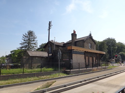
Turn left to start following St Andrews Street southeastwards. It crosses the A603 and becomes Hills Road; 0.7 miles after the city centre a junction with Station Road is reached on the left. Turn left down Station Road and follow it eastwards for a quarter of a mile until it reaches Cambridge railway station at TL461572.
At the station frontage turn right, passing a series of bus shelters to join a road that parallels the railway line on the left. The road passes under a bridge that carries Hills Road overhead before becoming a cycle path beside a Busway. These slowly start to angle away from the railway line on the left. The cycle path diverts to the right slightly to pass through an underpass below Long Road, before rejoining the Busway on the other side. Ignore a branch of the Busway heading off towards Addenbrooke's Hospital on the left and continue along the main path. It passes under another road bridge, and 2.3 miles after leaving the station, the Busway and cycle path go under another bridge. Immediately after this they curve to the left to reach Trumpington park and ride site at TL442542, where this walk ends.
 |
 |
|
Distances
| From | To | Distance (m) | Ascent (ft) | Descent (ft) |
|---|---|---|---|---|
| St Ives | Longstanton | 5.7 | 69 | 56 |
| Longstanton | Milton Road | 6.5 | 49 | 43 |
| Milton Road | Cambridge bus station | 2.3 | 20 | 16 |
| Cambridge bus station | Trumpington park and ride | 3.5 | 39 | 20 |
This makes a total distance of 18.0 miles, with 177 feet of ascent and 135 feet of descent.
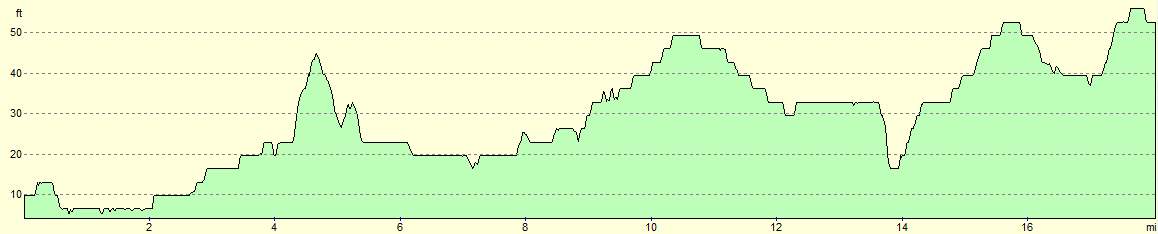
For more information on profiles, ascents and descents, see this page
Transport
The transport to get between St Ives and Trumpington park and ride is (in 2012) simple: just take one of the regular buses that travel along the Guided Busway route A.
 |
 |
|
 |
 |
|
 |
 |
|
 |
 |
|
 |
 |
|
 |
 |
|
 |
 |
|
 |
 |
|
 |
 |
|
 |
Disclaimer
Please note that I take no responsibility for anything that may happen when following these directions. If you intend to follow this route, then please use the relevant maps and check the route out before you go out. As always when walking, use common sense and you should be fine.
If you find any information on any of these routes that is inaccurate, or you wish to add anything, then please email me.
All images on this site are © of the author. Any reproduction, retransmissions, or republication of all or part of any document found on this site is expressly prohibited, unless the author has explicitly granted its prior written consent to so reproduce, retransmit, or republish the material. All other rights reserved.
Although this site includes links providing convenient direct access to other Internet sites, I do not endorse, approve, certify or make warranties or representations as to the accuracy of the information on these sites.
And finally, enjoy your walking!
Nearby walks
| # | Title | Walk length (miles) |
|---|---|---|
| 2 | Waterbeach to Newmarket Road, Cambridge | 5.4 |
| 5 | A short walk around Waterbeach to Car Dyke | 3.0 |
| 6 | Waterbeach to Newmarket Road, Cambridge | 5.4 |
|
|

|