Walk #925: Speyside Way: Buckie to Aberlour
 |
 |
|
General Data
| Date Walked | 19/09/2011 |
| County | Grampian |
| Start Location | Buckie |
| End Location | Aberlour |
| Start time | 07.07 |
| End time | 15.53 |
| Distance | 26.2 miles |
| Description | This walk follows the Speyside Way from its start point in the coastal town of Buckie, west along the coast to the mouth of the River Spey, and then finally south beside the river. It covers a wide variety of terrain, from coastal footpaths to forested tracks and roads. v |
| Pack | Today I carried my 30-litre Karrimor rucksack, filled with water, my waterproofs, a book and other odds and ends. |
| Condition | I feel surprisingly fine after what turned out to be a long walk without a break. The underside of my right foot ached at one stage, but this went away once I got off the roads and onto the softer paths. |
| Weather | Today was mainly sunny, bright periods with clouds interspersing occasionally. There were brief periods of drizzle, but this was never strong enough to force me to put my coat on. |
| OS map | Landranger number 28 (Elgin, Dufftown & surrounding area) |
 |
 |
|
Map of the walk
Maps courtesy of Google Maps. Route for indicative purposes only, and may have been plotted after the walk. Please let me have comments on what you think of this new format. For a detailed table of timings for this walk, please see the table file.
 |
 |
|
Notes
After finishing the Great Glen Way on Saturday, I took yesterday off so I could reposition myself ready to do the Speyside Way. This felt like a little bit of a bogey trail - it has a couple of dead-end routes leading off it which makes it difficult to walk the whole thing in one go. I spent yesterday doing some sightseeing, including a visit to the fantastic Fort George, which nestles in a narrowing of the firth. It is a fantastic and historic structure and the visit proved to be a very enjoyable three hours. The day off was fortuitous for another reason: it rained heavily late in the afternoon. I booked myself into a hostel beside the harbour in Cullen, and spent the early evening exploring this lovely village, which is dominated by an old railway viaduct.
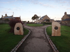
I got up early this morning to drive to that start of the Speyside Way in Buckie; I had reconnoitred the start point of the trail (which has recently moved) the previous afternoon and so I parked in the nearest car park and walked the short distance to the trailhead. This is marked by a couple of stones with discs embedded in them; one side says start' and the other 'end' depending on which way you walked the trail. This was a nice touch, and it is a shame that more trails do not mark their trailheads in such a manner.
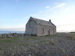
Initially the trail followed the road, and the sky that had been a brilliant red a few minutes earlier was now dominated by a low, dazzling sun. I walked through the western outskirts of Buckie before heading behind rows of neat houses - the conservation area of Yardie - to reach Buckpool Harbour, which has a stream trickling through it to the sea. A short while later it passed a large building with a turf-covered roof - an ice house, where ice was kept for preserving fish.
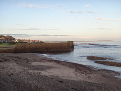
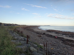
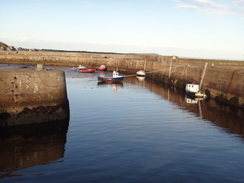
It was an enjoyable stroll, the only slight complaint being that the tide was out so that I was walking beside black rocks rather than sparking seas. This was a minor complaint, and soon I reached the harbour at Portgordon, a village I could not really recall much of from my previous visit. Sadly the harbour seemed overlarge because there were only a few boats in it - a direct contrast to the busy harbours of the south coast, and an indication of how the fishing industry has declined. Despite this it was neat, tidy and welcoming in the early morning sunshine.
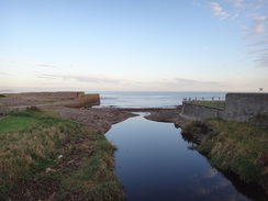
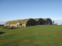
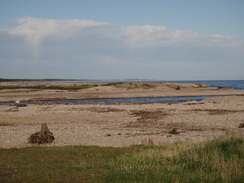
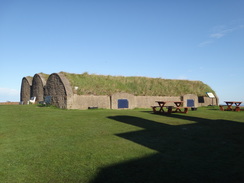
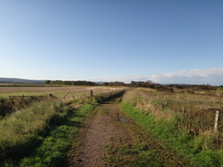
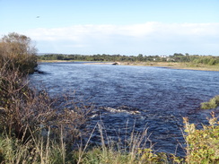
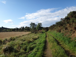
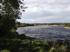
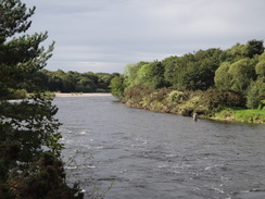
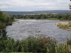
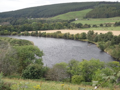
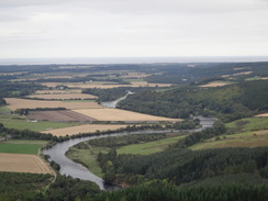
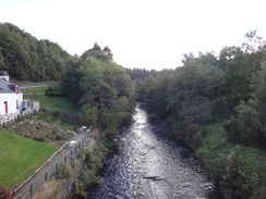
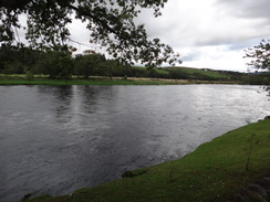
Soon the trail left the coast and joined an old railway line, which arrowed westwards for a mile across an area of flat ground. It then wound through the first forestry of the day, although thankfully the path was easy to follow before it dropped me out onto a road in Spey Bay. This headed onwards to reach the mouth of the mighty River Spey at the remarkably-named Tugnet. There is a dolphin centre here, along with three large arches buried under the ground - another ice house. Fond memories of my coastal walk came flooding back of this magnificent location, with the wide river flowing between boulders and shingle. It was easy to see over to the shingle on the other side of the river, and the width surprised me - it is truly a mighty river.
Good paths took me northwards up the western bank of the river, although soon it fell out of view behind trees and vegetation. A footpath led off to the right towards the old railway bridge over the river, which now carries a cycle path and was the route I had taken across on my coastal walk. I was tempted to go and see the bridge, but decided to press on as it was promising to be a long day.
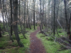
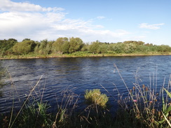
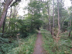
Tracks took me east of Culriach Wood before dropping me back beside the river, which annoyingly remained out of view behind a large bank that I had to climb to take photos. It was a relief when the bank ended and I could get unobstructed views; sadly the track soon ended at a footpath diversions sign. There was no avoiding this diversion - the track ended abruptly where it had been washed away by the river. I twisted my left foot slightly on the muddy diversion path, which soon entered Warren Wood. It headed southwards through this along good tracks, although annoyingly the river did not come into view again until the woods and the diversion ended. It would be good if some form of official diversion could be made nearer the river in future, but sadly that may not be possible.
A man with a large pack approached from ahead - he was in a smilingly good mood as he only had about ten miles to go to reach Buckie and the end of his journey. As we chatted he warned me about a nasty stretch of path coming up to the south of Grantown, which I should encounter tomorrow with any luck. He made it sound awful, and I wonder how bad it can really be.
The trail diverted away from the river once more to head through Bellie Wood and then approached Fochabers. Some workmen were moving spoil near the bridge that carries the A96(T) over the river, the only indication I saw of the large bypass that is under construction. A beautiful old iron railway bridge spans the river nest to the road bridge, but I never found a decent angle from which to photograph it. Besides, I had to plod on as I was not even halfway through the day.
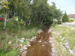
The trail disdainfully avoids Fochaber, choosing instead to follow the river for a short distance before joining a pretty stream. Soon I passed a burger van parked outside someone's house and was surprised to see that it was operating - I could not resist stopping for a bacon bun and a chat with the kindly woman behind the counter. I dared not ask how much trade she gets at this strange spot, but I doubt that I was her first walker!
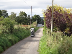
Sadly the next few miles were dominated by a long road walk southwards, climbing past Ordiquish before descending steeply into a little valley and up the other side. My ears are well attuned to the sounds of cars but I was surprised to hear a strange growling noise coming from behind - soon a man in a mobility scooter overtook me. A few minutes later I found it abandoned in a little car park beside a viewpoint as another form of transport - a fast jet - screeched unseen along the valley to my right.
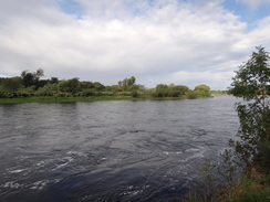
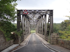
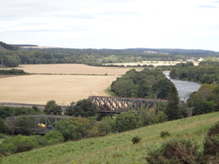
Over three miles later the road dropped down to reach the B9103 at Boat o Brig, so called because the bridge across the river was once swept away in a great storm. It was replaced by a ferry for many years before the new bridge was finally built. There are actually two large iron bridges here, the second carrying the railway line to Aberdeen - the only operational railway bridge of the many I passed today, showing how the railways in the area were obliterated by Beeching.
The trail got more interesting on the other side of the B9103 as it climbed along muddy tracks towards the farm at Bridgeton, with great views down over the river. Nearby I met a foreign couple walking in the other direction - they had big packs and had just done the West Highland Way to Fort William, then the East Highland Way to Nethy Bridge, and had then followed the Speyside Way to here. Their plans were to walk to the coast and then follow the Moray Trail westwards back towards Inverness, which would make for a very long trip!
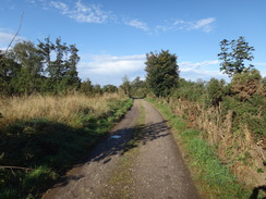
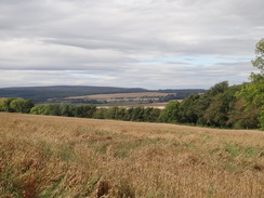
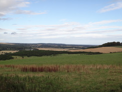
After skirting some trees, the trail entered the woodland proper and continued to climb. It made for a fairly uninteresting stretch of trail until, all of a sudden, a panoramic view unveiled itself down the valley towards Boat o' Brig, with the sea beyond. The magnificent vista stopped me dead in my tracks, and I moved onto the verge to get the best view. The drizzle that had been falling chose that moment to stop, and the sun emerged from behind a cloud. Most of today's walk was laid out in front of me, and I realised just how far I had come.
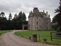
The trail contoured along tracks across the flank of Ben Aigan before falling to meet a road. Sadly this meant another three miles of road walking, of which only the final half mile was of any real interest, with some good views over the river to the right and a rather stately pile called Arndilly House. The road eventually emerged out onto the A95(T) at Bridge of Fiddich, which I had to carefully cross before entering a car park. A remnant platform edge showed that this had once been a station that had served the nearby village of Craigellachie.
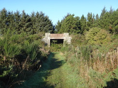
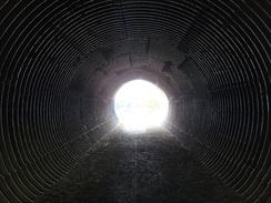
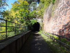
This was one of my possible endpoints of the day, but I was still feeling fit and knew that the bus that served Craigellachie also served Aberdour, a couple of miles further on. This would also mean that tomorrow's long walk would be somewhat reduced in length. I put my foot down and walked fast; at first the old railway line granted good views towards the river on the right, but soon it became invisible behind vegetation. The line ran along a ledge with the road high above; at one point it headed through a tunnel and I could not help but howl to hear the echoes come back.
I passed two men walking in the other direction; they were walking the trail and were making for their night's stop at Craigellachie. We had a quick chat but I was keen to get a move on as I was aware that a bus was due at about four from Aberlour, and I had no idea where to find the bus stop. I passed a sewage farm on the outskirts of the town and then a track with rails still set in the tarmac. Worried about whether I would find the bus, I stopped to ask a couple of men who were cutting some bushes where it was; one of them said that I could go through to reach it.
It proved easy to find and I watched carefully for the bus; annoyingly a stream of school coaches streamed past meaning that I had to keep a close eye out for the correct one. Then, all of a sudden, I saw it heading in the other direction; the destination board clearly said Elgin'. I stuck my thumb out from my side of the road but the driver just gave an apologetic shrug. I wracked my brain about why he would have been on that side of the road; it made no sense as he should have been heading south along the side of the road that I was on.
Disconsolately I trudged along the road towards the centre of the town, hoping to find a bus stop with a timetable on so that I would trace my mistake. As I did so, however, the same bus came back in the other direction on my side of the road. I raced towards a nearby bus stop and managed to get on. It arrived punctually in Elgin and I got off for the half-hour wait for a bus back to Buckie. Whoever when I got off I discovered that the bus I had just been on was going to Buckie! I clambered back on and started to drop off to sleep during the journey. It had been a strangely annoying day's walk; the views over the river had not been as frequent as a river walk demands, and the vast quantities of mud had been annoying after a virtually mud-free stroll along the Great Glen Way.
Tomorrow's walk promises to be difficult; it will be a 23 mile day to get from Aberlour to Grantown-on-Spey, but the transport back is almost impossible without a very late start. I think I will sleep on the problem and see what the weather in the morning brings...
 |
 |
|
Directions
This walk starts off at the northern trailhead of the Speyside Way in Buckie at NJ427656, which is marked by two large stones in a small park. Leave the stones and follow a broad concrete path away from a car park for a few yards until it goes through a gap in a low stone wall to reach the A942 North High Street.
Turn left to head down this road. As the road curves to the right in a hairpin bend, turn left down the A990 Bank Street; this soon curves to the right to becomes Baron Street. This road curves to the left to parallel the shore as it enters the Yardie Conservation Area of Buckie. Immediately after the bend, turn right down a minor road that parallels the shore with houses on the left and grass on the right. After a fifth of a mile this road curves to the left to rejoin the A990.
Turn right and follow the road as it crosses the Burn of Buckie using a bridge, and then head on past a little car park and Buckie Harbour on the right. Turn right down the entrance into the car park by a yard or two, and then turn left down a gravel path that runs across grass parallel to the road on the left. The path soon ends at a minor road; continue straight on along this road. Continue westwards along this road for a quarter of a mile until it curves to the left. Do not follow the road, and instead head straight on along a gravel track. Ignore the first track off to the left and then take the second to rejoin the A990 at NJ415654.
Turn right and follow the A990 west-southwestwards for another third of a mile until NJ410651 a track leads off to the right, angling towards the shore through gorse bushes. After about twenty yards turn left at a crossroads with a path, turn left down a path that leads towards a rather ramshackle building. Near the building turn left to follow another path that parallels the shore.
After a third of a mile at NJ406648 the path joins the A990 once more, with a railway bridge to the left. Turn right and follow the road as it crosses a bridge over a stream; immediately on the other side turn right to rejoin the good path that parallels the shore. After 0.4 miles the path reaches the eastern outskirts of Portgordon, passing a turf-roofed hut on the left (an old ice house). The path becomes a track as it passes behind stone buildings on the left; it then becomes a surfaced road.
This road curves gently to the right and then the left to pass some houses on the left. When the road ends curves sharply to the left turn half-right along a surfaced track which curves to the left to reach the eastern wall of Buckie Harbour. Turn left down this road to pass a car park on the left; the path son becomes surfaced until it reaches Hope Street, which runs in front of the harbour, at NJ396642.
Continue along this road, initially keeping the harbour to the right before the road curves to the left to end at a T-junction with the A990. Turn right and follow the A990 westwards next to the shoreline; there is a good pavement on the right. After a sixth of a mile the A990 curves to the left uphill; head straight on along another road, Lennox Place that continues to run along the shore. This becomes Stewart Street; after a quarter of a mile the road curves to the left past the last house on the left to head inland. It soon curves to the right once more and approaches a ramp that leads up to a bridge over an old railway line.
Just before the bottom of the ramp is reached at NJ387641, turn left through a gate and then turn immediately to the right to join the old railway line. Continue eastwards along the old railway line for a little under a mile until an old overbridge is reached at NJ372641, passing through several gates on the way and crossing a footbridge across a stream.
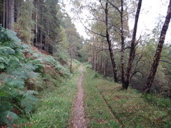
This overbridge has been filled in; just before the bridge is reached the path turns to the right to parallel the approach ramp onto the bridge for about 150 yards. Turn left across the track to join a path that heads through some woodland. After a quarter of a mile the path turns to the right to head deeper into the woodland. As it approaches the northern edge of the trees the path curves to the left; the path is clear but quite narrow. After half a mile the path curves to the left to wind through the trees towards a road; when the path forks take the right-hand branch which continues through the trees with the road a short distance away to the left.
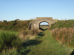
The path exits the trees and climbs some steps to join a high fence on the right. Keep the fence to the right as houses appear to the left. It passes a high concrete tower on the left and joins a road at NJ354650. Turn right and follow the road as it heads northwards; it soon curves to the left to continue west-northwestwards with cottages to the left. When the road forks take the right-hand branch; this passes the three arches of a concrete ice house to reach a car park right by the mouth of the River Spey at NJ348653.
Turn left and follow the path through the car park, and when it ends turn left along a path that immediately curves to the left to run behind the ice house and a visitor's centre; do not take a footbridge that leads off to the right. The path heads eastwards for a couple of hundred yards until a track leads off to the right. Turn right along this track and follow it as it immediately crosses a bridge over a stream; this soon meets the eastern shore of the Spey and parallels this southwards, although the river often remains out of sight through trees to the right. The track becomes surfaced as it continues on; head straight on as a track comes in from the left carrying a cycle path.
0.7 miles after the bridge over the stream, the track curves to the right to head over the Spey Viaduct, by which Garmouth on the western bank of the river can be reached; however the Speyside Way continues straight on southwards along a rough track. It passes Culriach Wood to the right, but the trees are eventually left behind and replaced with a field; two-thirds of a mile after the viaduct junction the track curves to the right a couple of times to head westwards towards the southern tip of Culriach Wood.
A couple of hundred yards after the right-hand bend at NJ348629, just before the woodland is reached, the track forks. Take the left-hand branch; this soon reaches a larger track; turn left down this track to run alongside a large bank on the right. The Spey lies out of sight behind this bank.
After 0.4 miles the track ends at NJ347622, where it has been eroded by the Spey. The official route of the trail has now been swept away, so a diversion path heads off to the left. A sometimes-muddy path follows a little bank that emerges out onto the edge of a field on the left, then shortly afterwards turns right into some woodland. It crosses a stream and continues on through the trees before joining a stony track. Turn right down this for a few yards until it reaches a better track, and then turn left down this new track.
At NJ345613 it meets a better track; turn left down this track to head deeper into the woods. As the main track curves to the left after 100 yards, continue straight on down another track that heads south.
After 0.4 miles the track reached a metal vehicle barrier; go to the right past this and turn right along a track for a few yards before turning left over a bank; here the original route of the Speyside Way is rejoined. The river is off to the right, and some good views can be had over the river as they both head south. After a quarter of a mile the river curves away to the right and the path enters Bellie Wood. It slowly curves to take a more northwesterly course to reach a bridge that carries the A96 high overhead at NJ340594 on the outskirts of Fochabers.
Head under the road bridge, and then immediately under a stone approach arch to the adjacent disused railway viaduct; after this it enters some more woodland. When the track forks, take the right-hand branch that parallels the river southwards. As this path approaches a grassy area of parkland it turns sharply to the left, heading up with trees on the left and parkland on the right to reach a little car park at NJ341590.
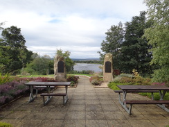
Pass the car park on the right, then turn right to head south along a road. This curves to the left and passes a little garden dedicated to famous Fochaberians - a pleasant touch, and there are list of famous people from the town along with grand views down over the river. Pass the garden and follow the path as it reaches the western bank of the Burn of Fochabers beside a footbridge. Do not cross the footbridge and instead turn left to start heading upstream.
The path crosses a road, with a bridge off to the right; cross this road and continue on, still with the stream on the right. When the path reaches a second bridge at NJ344585 join the road and turn right to cross the stream. This road immediately ends at a T-junction on the other side of the bridge; here continue straight on along West Street. It passes a school on the left; when the road reaches a little roundabout with the school on the left, continue straight on along a path that squeezes beside a field gate before following a fence on the right.
When this path ends at a T-junction with another path, turn left along this new path which continues between hedges. This path ends at the surfaced Ordquish Road at NJ344580; turn right and follow this road as it heads southwestwards. After a quarter of a mile the road curves to the left and then right, starting to climb with Castle Hill off to the left before levelling out and heading in a southwesterly direction past Ordiequish. At Upper Ordiequish the road curves to the left to take a more southerly course.
Half a mile after Upper Ordiequish the road passes a car park for the Earth Pillars on the left, then descends steeply, curving to the right to cross a stream on a bridge. Shortly after crossing the bridge the road curves to the left and then steeply climbs back uphill; as the gradient slackens it curves to the right to pass the farm at Culfodie. Continue along the road as it heads in a rough southerly direction with woodland on the left; three miles after the bridge the road descends steeply, curving to the right and then the left in hairpins before reaching a bridge over a stream at NJ320518.
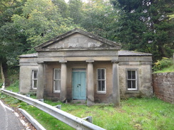
Cross this bridge and continue south along the road; it soon curves to the right and then the left to pass under an arched railway bridge before ending at a T-junction with the B9103 at Boat o' Brig, with a Speyside Way car park on the right. Turn right along this road for about ten yards towards the bridge over the river; just before an ornate stone building is reached on the left, cross the road and turn left along a path that starts climbing steps uphill into woodland. Almost immediately the path curves to the left and joins a track. This curves to the right, with the road and railway line below to the left. As it curves to the right it starts to plunge downhill; before it does so turn right to start climbing another track that heads uphill to the south.
There are some good views over the river to the right as the track climbs. A third of a mile after leaving the road, some gates are reached before Bridgeton Mains farm. Do not pass through the gates and instead turn left along a track, keeping an area woodland on the right. The track curves to the right to meet a T-junction with another track at NJ320511. Turn left and follow this track as it heads eastwards, passing a cottage on the left.
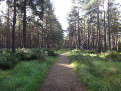
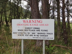
After a quarter of a mile the track enters some woodland; a few yards on a track leads off to the right. Squeeze past a field gate on the entrance to Ben Aigan Forest and follow the track as it curves to the right; do not be concerned about the warning signs about a shooting range as the track keeps away from any danger. Soon after entering the forest the track curves to the left turn to the right along a faint, muddy track. This continues in a rough southwesterly direction with the forest on the left.
Shortly after trees start on the right, the track curves to the left, heading steeply uphill with the Allt Daley flowing downhill to the right. At NJ315496 it joins another forestry track; turn right and continue as this track continues to climb, crossing a bridge over a stream before curving to the right and descending slightly to cross the main Allt Daley on a high bridge. On the other side it continues climbing uphill, curving to the left to cross the Allt Clachan Ban on another bridge, then descends to the Rocky Burn. After this there is a slow and steady descent as the path continues to twist and turn. It crosses the Sandyhill Burn; shortly afterwards at NJ298489 turn right down another track, which gently descends on a southwesterly course.
Continue past a field gate and continue until the track ends at a road at NJ290483. Turn left down this road and follow it as it slowly curves to the right and then the left before descending southeastwards. 1.1 miles after joining the road it turns sharply to the left, with the impressive Arndilly House through gates on the right. Soon afterwards the road curves to the right to cross the Burn of Arndilly and then settles on a more southerly course.
After another 1.2 miles it crosses the Macdowall Bridge over a stream; shortly afterwards another road comes in from the left at NJ295457. Continue straight on along the road for another 0.4 miles until it reaches a T-junction with the A95(T), with the Fiddichside Inn immediately to the left. Turn right to join the main road and follow it as it immediately crosses the River Fiddich on a high bridge and curves to the right; shortly afterwards turn left through a gap protected by plastic bollards to join a path that leads into a car park.
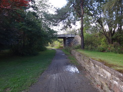
Once in the car park, turn right to join an old railway line. It passes an old platform on the right and then heads under a bridge that carries the A95(T) overhead. The line then goes past a field gate and curves to the left, squeezing above the river to the right around the outskirts of Craigellachie. It passes under another road bridge (again carrying the A95(T) overhead), with the Craigellachie Hotel up to the left.
The path then climbs slightly to the right to pass once more under the A95(T). On the other side it curves to the left to parallel the road, before heading through another tunnel. On the southern side of the tunnel it passes over a bridge with an enormous retaining wall to the left, with the Spey down to the right. It goes through an field gate and continues on; it passes a lorry yard on the left and a sewage farm on the right as it approaches Aberlour.
Pass through a metal field gate to reach a track; the best way of reaching Aberlour is to turn left down this track for a short distance until it ends at the A95(T) at the northern end of the town, then turn right to head through the town. The main bus stop is situated at the main town square at NJ265429, although the road is lined with several other stops.
 |
 |
|
Distances
| From | To | Distance (m) | Ascent (ft) | Descent (ft) |
|---|---|---|---|---|
| Buckie | Tugnet | 6.1 | 249 | 322 |
| Tugnet | Fochabers | 5.1 | 148 | 39 |
| Fochabers | Boat o' Brig | 5.3 | 686 | 594 |
| Boat o' Brig | Craigellachie | 7.3 | 1444 | 1365 |
| Craigellachie | Aberlour | 2.4 | 190 | 190 |
This makes a total distance of 26.2 miles, with 2717 feet of ascent and 2510 feet of descent.
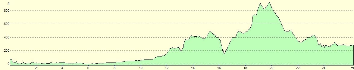
For more information on profiles, ascents and descents, see this page
Accommodation
I spent the night at the Cullen Harbour Hostel, which is spectacularly sited right by the sea and harbour in the small fishing village.
Transport
Two bus journeys were needed to get back from Aberlour to
- Stagecoach service 336 between Aberlour to Elgin; this bus runs every hour during the day, with very infrequent services on Sundays). This bus service starts at Dufftown and also calls at Craigellachie, giving you an option to shorten the day if you desire.
- Stagecoach's service 305/325 between Inverness and Aberdeen calls at both Elgin and Buckie. There is a service roughly every hour during the day, and every couple of hours on Sundays.
 |
 |
|
 |
 |
|
 |
 |
|
 |
 |
|
 |
 |
|
 |
 |
|
 |
 |
|
 |
 |
|
 |
 |
|
 |
 |
|
 |
 |
|
 |
 |
|
 |
 |
|
 |
 |
|
 |
 |
|
 |
 |
|
 |
 |
|
 |
 |
|
 |
 |
|
 |
 |
|
 |
Disclaimer
Please note that I take no responsibility for anything that may happen when following these directions. If you intend to follow this route, then please use the relevant maps and check the route out before you go out. As always when walking, use common sense and you should be fine.
If you find any information on any of these routes that is inaccurate, or you wish to add anything, then please email me.
All images on this site are © of the author. Any reproduction, retransmissions, or republication of all or part of any document found on this site is expressly prohibited, unless the author has explicitly granted its prior written consent to so reproduce, retransmit, or republish the material. All other rights reserved.
Although this site includes links providing convenient direct access to other Internet sites, I do not endorse, approve, certify or make warranties or representations as to the accuracy of the information on these sites.
And finally, enjoy your walking!
Nearby walks
| # | Title | Walk length (miles) |
|---|---|---|
| 547 | Lossiemouth to Portknockie | 20.8 |
|
|

|