Walk #904: A circular walk between Cromer and Sheringham
 |
 |
|
General Data
| Date Walked | 25/05/2011 |
| County | Norfolk |
| Start Location | West Runton campsite |
| End Location | West Runton campsite |
| Start time | 05.28 |
| End time | 09.21 |
| Distance | 10.3 miles |
| Description | This was a short circular walk that took in the eastern end of the Norfolk Coast Path, as well as the long, sandy beach that rusn between Cromer and Sheringham. |
| Pack | Today I carried my 30-litre Karrimor rucksack, filled with water, my waterproofs, a couple of books and other odds and ends. |
| Condition | I feel absolutely fine after this walk. |
| Weather | The high winds of the previous two days had died down, but the skies remained sunny with scarcely a cloud in the sky. It would get warm later in the day, but the temperature when I walked was just about perfect. |
| OS map | Landranger number 133 (North East Norfolk, Cromer & Wroxham) |
 |
 |
|
Map of the walk
Maps courtesy of Google Maps. Route for indicative purposes only, and may have been plotted after the walk. Please let me have comments on what you think of this new format. For a detailed table of timings for this walk, please see the table file.
 |
 |
|
Notes
I spent another night last night in the awning of my parent's tent, and although it was a much colder night it was warm enough for me to unzip most of my sleeping bag. Frost had been forecast, but the grass was clear when I awoke before five. Yesterday I had walked along the Norfolk Coast Path as far as Sheringham, leaving the remaining five miles to be done. Instead of coming back to Norfolk another time I decided to complete it this morning before driving back to Cambridge.
I set off at five thirty, after loading my gear into the car. Fortunately the campsite as right beside the trail, so it was easy to just walk out of the gate and onto the track. It was not a cold morning and there was scarcely cloud in the sky - it looked as though it was going to be a stunning day for a short stroll.
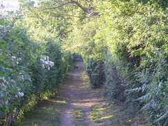
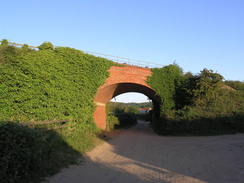
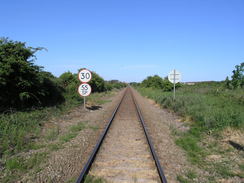
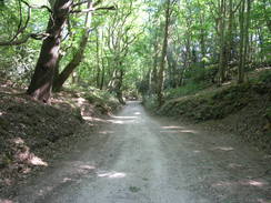
Initially the trail joined a track that slowly descended; the trees that lined it shaded me from the sun and I came across a small deer in front of me. It regarded me with mild curiosity and stayed where it was as I approached. Eventually it bolted, but only when I was about ten yards away. The track wound a fair bit, but navigation was easy enough and the trail was well waymarked. It crossed a road and passed under a grand brick arch that carried the railway line to Cromer overhead; a train passed over shortly after I went under, presumably the first train of the day.
The trail followed a track up Roundabout Hill, from where I got my first views of the sea for the day. It joined a road that led to the main road on the outskirts of Cromer. This took me past the railway station and down towards the town. As I entered the town the batteries on my Dictaphone ran out; fortunately a petrol station had just opened and I nipped in to buy a new set. What followed was a most enjoyable banter with the man serving, who was obviously waiting for the deserted forecourt to fill.
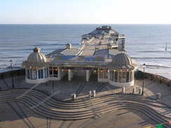
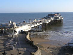
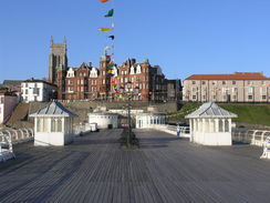
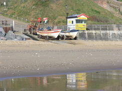
It is not obvious where the trail finished in the town, so the fantastic pier seemed as good a place as any. I headed along a narrow path above the pier before taking a sloping path that led down to the promenade. The pier entrance was open and I took a stroll along it, enjoying watching the surf breaking through the gaps in the planks. A sign stated that people walking down the pier were being recorded by ITV, I wonder why and for what program?
The head of the pier is dominated by the RNLI lifeboat houses, whilst the smart promenade at the shore end was marked with a semicircle of radiating lines, each one the direction of an important rescue performed by the lifeboats. This attention to detail is typical of Cromer and why I prefer it to the nearby Sheringham. It has less amusement arcades and more teashaops, although Sheringham has the advantage of a steam train!
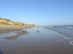
Although Cromer was officially the end of the trail I still had the section from Sheringham to the campsite. Instead of walking back along the trail to Sheringham and then returning to my car, it seemed sensible to follow the beach instead. The tide was out, exposing a wide expanse of wonderful golden sand. Someone had erected a small tent on the beach at the end of the promenade and I wondered how long it had been there.
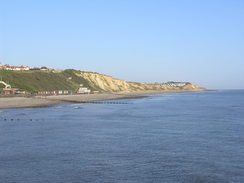
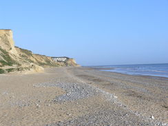
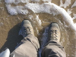
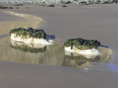
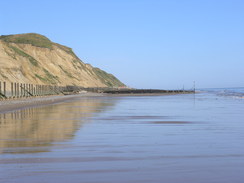
What followed was a superb stroll along the beach with cliffs off to the left. The sand was firm and the going easy; I walked into the surf for the traditional washing of my boots in the sea. Only a few people were on the beach, including a couple of cyclists who seemed to be finding the going hard over the sand. I revelled in the reflections of the sky on the sea-washed sand.
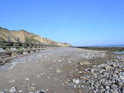
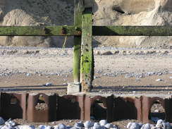
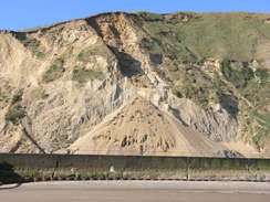
The going became harder after passing the gap at West Runton; the sand became a rocky surface and dishevelled wooden wavebreaks stood between the beach and the cliffs. Many of these had nearly completely disintegrated and holes had been eroded in some of the metal piles beneath. Much work on these defences will be needed in the near future if the cliffs are to be protected; their state reminded me of some at Happisburgh that had been allowed to fail with calamitous results for the houses above.
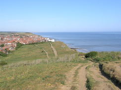
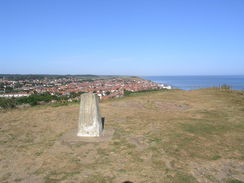
Fortunately the sand soon restarted and I had an easier walk for the last few hundred yards into Sheringham. I joined the promenade and walked into the town, making sure that I reached the point that I had left the trail yesterday, and then started back. Some steps led up the cliffs from where a path led me up to the top of a hill. I remembered this hill with fondness from previous visits, and the views from the trig pillar at the top were just as good as before. I let the sights sink in before going down the steep path on the other side.
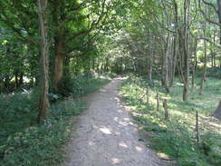
After crossing a railway line, a track led to a main road. Another track headed past a farm towards a wooded area, before plunging uphill through it. Near the top of the hill I met a man walking down the other way; he looked like a walker but was wearing leather shoes instead of boots. He said he was following the coastal path for ten miles to Wells-next-the-Sea, and he was dismayed when I told him it was actually over twenty miles away. A nearby sign warned that Adders might be found on the ground, but there was no sign of any as I strode uphill.
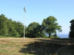
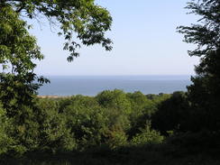
The ascent was long, but soon I found the path emerge out next to an open area, with a flagpole to the left. This marked the summit of Beacon Hill, at 102 metres the highest point in Norfolk. I hardly needed any extra oxygen to reach such an extreme summit, and my crampons and ice-axe remained firmly in my pack! The trees had been cleared to allow a view of the sea, and it was well worth stopping for a minute to admire the scenery below.
The track led to a narrow lane, after which a long and stony track wound downhill towards the entrance of the campsite. I reached my parent's van just before half nine, a great time to have completed a ten-mile stroll. It had been a great walk, and the beach stretch in particular had been superb. I now had the rest of the day to explore Cromer and to drive back to Cambridge.
 |
 |
|
Directions
This walk starts off at the camping and caravanning clib campsite at TG188419; it can also be started in either Cromer or Sheringham by starting at the relevant point in the directions below.
Leave the caravan site through its main entrance and turn left to start walking along an unsurfaced track. This curves to the right as it descends to take a more easterly course, skirting the campsite on the left. Go through a gate at the eastern end of the campsite and follow the track downhill. A quarter of a mile after the campsite the track goes through other gates to emerge into a small field; turn half-left across this to reach a triangular track junction. Turn half-right to head southeastwards along another track that heads uphill.
This turns sharply to the left and then the right to join a wider track with a hedge on the left. This continues eastwards before ending at a road at TG198416. Cross the road and continue up another track, almost immediately passing under an imposing red-brick railway bridge. The track ascends a hill between hedges; near the top it curves slightly to the left to take a more east-northeasterly direction. Half a mile after the railway bridge it reaches a surfaced road. Cross this and continue up Sandy Lane, passing houses on the right. After a quarter of a mile the road ends at a T-junction with the A148 Holt Road at TG211419.
Turn left and start following the A148 southeastwards, passing Cromer Railway Station on the left. After a third of a mile it reaches a mini-roundabout with the A149. Turn left to follow the A149 northwards; it passes a petrol station on the right before ending at the top of the cliffs. As the road curves to the left, turn right along New Street for a few yards before turning left and then right to join a narrow footpath called West Cliff that runs eastwards with the cliff edge on the left and houses on the right. This emerges at the Hotel de Paris on the right. Pass this and then turn left to take a sloping zig-zag ramp that leads down to reach the promenade directly in front of the pier. This seems as good a place as any to end the North Norfolk Coast Path.
If you want you can choose to walk along the pier and back again to the promenade.
Next, we need to walk along the coast to Sheringham. The following directions should only be used if the tide is out; if the tide is high, or is going to get high, then choose a safer route along the top of the cliffs and roads. You will have to walk along the A149 for 1.3 miles if you take the clifftop route.
Otherwise follow the promenade westwards. When it ends drop down onto the beach; the end of a road at West Runton is reached 1.7 miles after the end of the promenade. The next stretch of beach is rocky and has dilapidated sea defences that may need to be carefully negotiated. Fortunately this does not last long and the sandy beach is soon resumed. Sheringham's promenade begins once more at TG165434; this can be followed for a short distance westward to the point where the Norfolk Coast Path is reached (where some steps lead off to the left). However I walked on a short distance towards the Mo Museum in the centre of the town, where I had left the Norfolk Coast Path yesterday.
Cross this bridge and continue on along the promenade and pass the Mo (otherwise known as Sheringham Museum). Pass a slipway by the museum and continue eastwards along the promenade for another 250 yards until some steps lead up to the right at TG162434. Climb these steps, and at the top continue on up a slope.
At the top of the slope turn left along a rough road; when this soon ends continue on along a path that heads eastwards along the top of the cliffs. It climbs steeply up steps to reach a trig pillar at the top of Beeston Hill. Pass this and continue down the other side, which plunges steeply down some steps. Continue across the field as the gradient slackens and when a fence is reached guarding a caravan site ahead, turn right to walk south with the fence and the caravan park on the left.
The path joins a track at the southern end of the caravan site; follow this for a few yards towards a level crossing. Go through the pedestrian gate and carefully cross the railway line. Go through the gate on the other side and follow the track south for a sixth of a mile until the A149 road is reached.
Carefully cross the A149 road and turn left for a few yards before turning right to head eastwards along a surfaced track. When this curves to the left, turn right to head south along a rough track. It passes a farm on the left; after half a mile it reaches a T-junction with Calves Well Lane at TG174419. Turn left to head eastwards along this lane, but after a short distance fork right up another rough track and pass through a wooden squeeze-stile. This heads uphill southeastwards; after the gradient slackens it goes through a gate to cross a track. After 0.6 miles the path passes the fence of the Roman Camp Caravan Park on the right and reaches a car park at the very top of Beacon Hill. Norfolk's highest point is at the flagpole a few yards away to the left.
Continue on along a surfaced track that soon becomes unsurfaced as it heads eastwards to reach a narrow road. Cross this and continue on along a rough track. Almost immediately this forks; take the better left-hand fork as it descends downhill to reach the entrance to the campsite where this walk started.
 |
 |
|
Distances
| From | To | Distance (m) | Ascent (ft) | Descent (ft) |
|---|---|---|---|---|
| Campsite | Cromer Pier | 2.4 | 141 | 312 |
| Cromer Pier | Sheringham | 4.2 | 30 | 20 |
| Sheringham | Campsite | 3.5 | 538 | 377 |
This makes a total distance of 10.1 miles, with 709 feet of ascent and 709 feet of descent.
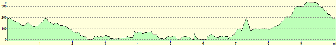
For more information on profiles, ascents and descents, see this page
 |
 |
|
 |
 |
|
 |
 |
|
 |
 |
|
 |
 |
|
 |
 |
|
 |
 |
|
Disclaimer
Please note that I take no responsibility for anything that may happen when following these directions. If you intend to follow this route, then please use the relevant maps and check the route out before you go out. As always when walking, use common sense and you should be fine.
If you find any information on any of these routes that is inaccurate, or you wish to add anything, then please email me.
All images on this site are © of the author. Any reproduction, retransmissions, or republication of all or part of any document found on this site is expressly prohibited, unless the author has explicitly granted its prior written consent to so reproduce, retransmit, or republish the material. All other rights reserved.
Although this site includes links providing convenient direct access to other Internet sites, I do not endorse, approve, certify or make warranties or representations as to the accuracy of the information on these sites.
And finally, enjoy your walking!
Nearby walks
| # | Title | Walk length (miles) |
|---|---|---|
| 165 | Cley-next-the-Sea to Cromer | 13.1 |
| 168 | Cromer to North Walsham via Mundesley | 12.8 |
| 255 | Wells-next-the-Sea to Sheringham | 19.8 |
|
|

|