Walk #902: Hunstanton to Wells-next-the-Sea
 |
 |
|
General Data
| Date Walked | 23/05/2011 |
| County | Norfolk |
| Start Location | Hunstanton |
| End Location | Wells-next-the-Sea |
| Start time | 08.01 |
| End time | 16.11 |
| Distance | 23.8 miles |
| Description | This was a pleasant walk following the North Norfolk Coast Path eastwards. |
| Pack | Today I carried my 30-litre Karrimor rucksack, filled with water, my waterproofs, a couple of books and other odds and ends. |
| Condition | I feel absolutely fine after this walk. |
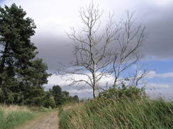
| Weather | The main feature of today's weather was the wind, which was fierce and gusting. It was a mostly sunny day, meaining that I was overly warm when sheltered from the wind, but the breeze meant that I could not take my fleece off. |
| OS map | Landranger number 132 (North West Norfolk, King's Lynn & Fakenham) |
 |
 |
|
Map of the walk
Maps courtesy of Google Maps. Route for indicative purposes only, and may have been plotted after the walk. Please let me have comments on what you think of this new format. For a detailed table of timings for this walk, please see the table file.
 |
 |
|
Notes
My parents were staying at a campsite near Cromer for a few days, which felt like a good opportunity to walk the North Norfolk Coast Path, which is part of the Peddars Way and North Norfolk Coast Path. I have walked much of this path twice before, but the coastal scenery is always worth another visit. The forecast was for good weather aside from a brisk breeze, so I packed up the car with my gear and set off for the drive to Hunstanton.
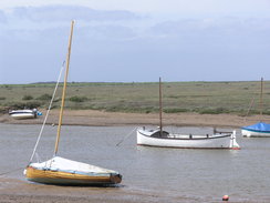
I parked up in a car park near the centre of the seaside town, with good views over the promenade and the sea. The main problem was evident the moment that I got out of the car - the wind was fierce enough to blow my notepad off the car's roof as I packed my gear. Fortunately the skies were clear, meaning that there was no immediate threat of any rain, and the breeze was warm. The sea was white with small breaking waves, and a small vessel was being tossed roughly around.
It is hard to know exactly where the Hunstanton branch of the coast path begins, so I decided on the village sign on Cliff Parade, a short stroll away from the bus station. Initially the trail follows the main road northwards, with a broad area of grass stretching between it and the cliff edge. I had walked this many times before, so instead of taking the more scenic route along ht edge of the cliff I followed the road.
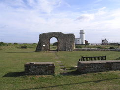
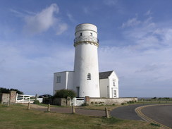
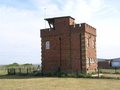
Soon a flint archway appeared in front of me; this is the ruins of St Edmund's Chapel, which dates back to at least 1272 and commemorates the landing of St Edmund in 855, after which he was crowned as King of East Anglia. Towering behind this is the large lighthouse which really stood out with its brilliant white paintjob. This was built in 1840 on the site of an older lighthouse that was in operation since 1665. Beyond this was a brick-built coastguard lookout dating from 1907. This trio of buildings is quite spectacular, both in the scale, history and variety.
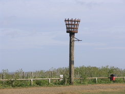
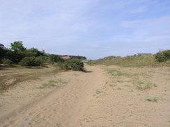
The trail headed down through the car park and skirted between a patch of woodland and the sea to reach the lifeboat station in Old Hunstanton. This is a shame as it means that the walker does not get a view of the red-and-white striped cliffs, for which the town are famous. Here the maps show the path as heading inland along roads to skirt landward of a golf course, but signs on the ground pointed to seaward of the course. This turned out to be an easy walk behind the dunes, albeit with few views of the sea. I have walked this stretch of beach on many occasions, and it is a much preferable stroll to this route behind the dunes. In the distance a large wind far could be seen out to sea; possible the North Sea Wind Farm. It was hard to count the number of turbines through the hazy skies, but I think that there were probably twenty-five.
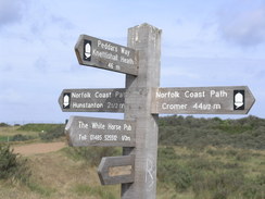
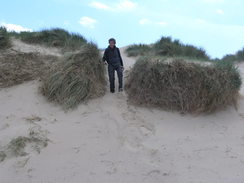
The path met a track that headed inland a short distance towards Holme-next-the-Sea to reach a fingerpost with many different paths leading off from it. This is where the Peddar's Way meets the Norfolk Coast Path, and I took a photograph another walker turned up. He looked as though he was ready for a long day's walk, and it turned out that he was walking from Hunstanton to Wells-next-the-Sea as part of a stroll along the entire coast path. We continued chatting as we walked together along the path. David had taken the path as shown on the map, heading inland past the golf course.
He is walking all the National Trails over a number of years, and this is the latest one for him to tick off his list. There was a significant amount of overlap in the ones we had walked and this gave us a great deal to talk about as we walked. A good path took us past an RSPB reserve and down into Thornham, where an utterly unnecessary diversion inland occurred. I have never quite understood why the national trail makes this diversion, especially as the path runs behind the reverse of a hill, preventing any views of the sea. We made good time on this stretch, and soon we were heading back down towards the coast at Brancaster.
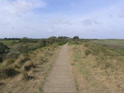
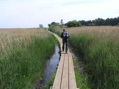
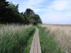
I have always like Brancaster, but there was still a long distance to walk if we were to make it to wells before the last bus. The trail follows a road to seaward before taking a long stretch of boardwalk eastwards behind the houses and gardens. This felt like a motorway and allowed us to make swift progress, although this was not the case for the couples who were trying to push wide tricycle prams across the narrow sleepers. On the way we passed the site of Branodunum, the site of a Roman fort first built in the 230s AD. It once lay on the coast, but unlike much of the East Anglian coastline there has been a great deal of deposition here and the fort now lies inland.
The trail headed seaward of Brancaster Staithe and then Burnham Deepdale, where I realised that I had yet again managed twelve miles before midday. This seemed like a good time to stop, so we hunkered down out of the wind to eat our sandwiches. The wind really started to catch us as the trail rejoined the flood banks, the strongest of gusts being enough to cause me to sway. I normally carry walking poles on my pack but I had forgotten them on this trip, and so I was left envying David his pole, which was making it easier for him to walk in the wind.
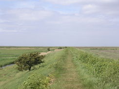
Fortunately the wind was coming from the southwest, meaning that it was behind us for much of the time. This changed as the flood bank turned to head south towards Burnham Overy Staithe and we were exposed to the full fury of the wind. It was a relief when the bank finally turned to head eastwards, soon joining a road to head into the village.
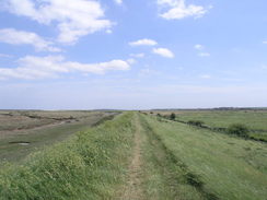
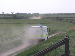
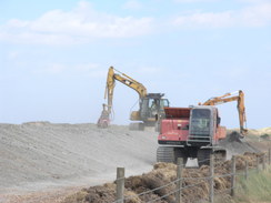
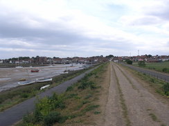
More flood banks took us out of the village. Signs warned of works, and soon long-jibbed diggers became visible in the distance. A police car and an RAF bomb disposal van came down the track towards us, away from the diggers; I guess that the diggers might have found something suspicious. The machines were reforming the shape of the flood bank, but a good diversion path had been created parallel to the bank.
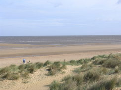
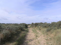
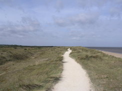
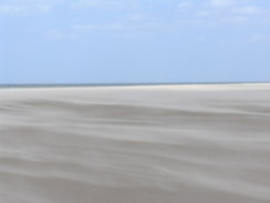
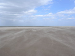
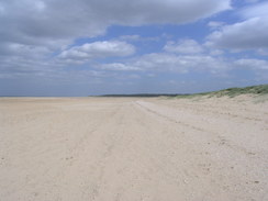
Soon the coast was reached once more, and we climbed the sand dunes to reach the beach. Here the 1:25,000 and 1:50,000 maps show a different route for the trail; the former shows it on the inland side of the dunes, whilst the latter has it along the beach. I chose the latter and we struggled along the soft sand. The wind was picking up the sand and blowing it in flowing lines towards the sea. It was so thick that the blow sand looked like a mist in the distance; it was the best examples of this phenomena that I can recall seeing.
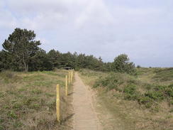
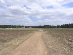
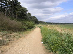
Eventually the trail curved inland slightly to reach Holkham Gap, heading towards a car park. We stopped off at a well-stocked snack van for a quick drink, and I used the opportunity to empty some sand out of my boots. There was only a couple of miles left to go, and most of this was through some woodland that kept the worst of the wind off us. This stretch of path was fairly popular with other walkers and we were hardly alone as we strolled.
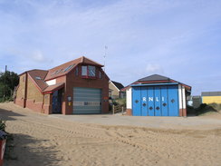
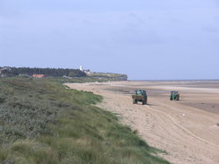
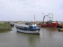
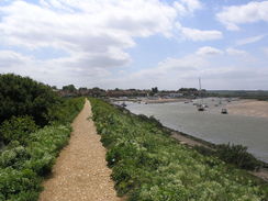
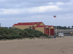
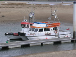
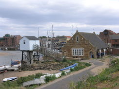
The trail emerged out at the end of the road that leads north from Wells, with the vast expanse of the Wells Salt Marshes beyond. We strolled past the car park and cafe to climb up the sea wall that protects the low-lying land from the sea. From here there was a good view of the isolated lifeboat station and also of a new mini-harbour whose pontoons were filled with boats that support the construction and operation of offshore wind farms.
We were exposed to the wind once again as we headed south into Wells, and it was a relief when we could stagger off the bank and onto the roads. The next problem was where the busses back to Hunstanton left from; this turned out to be from beside a pub called the Ark Royal. It was not clear when the bus left from my pocket timetable, so we went inside for a quick celebratory drink. A bus came as we sipped our drinks and chatted, but another arrived after another half an hour. It took a little under an hour for the bus to get us back to Hunstanton, and I said goodbye to David having thoroughly enjoyed his company during the stroll. I was faced with an hour's drive to the campsite my parents were staying at near Cromer, meaning that it ended up being a very long day.
It had been a good day's walk despite the wind, and the distance walked could make it possible to walk to the end of the trail in Cromer tomorrow. I will see in the morning if attempt another long walk in the morning, or if I cut the walk short and end in Sheringham.
 |
 |
|
Directions
There is no marker showing the starting point of the North North Coast Path in Hunstanton, but the junction of Greevegate and the B1161 Cliff Parade at TF672408 seems like as good a place as any. Follow Cliff Parade northwards for three-quarters of a mile out of the town; eventually it starts curving to the right. Instead of walking along the road you can instead choose to walk along the grass beside the edge of the cliffs on the left for much of the way. Shortly after passing the ruins of an old church on the left turn left down Lighthouse Close. This passes an old lighthouse on the left and curves to the right as it approaches the cliff edge; when the road ends continue on to descend through a car park with the cliff edge to the left. At the bottom of the car park it reaches a track in front of some woodland at TF679423.
Turn left along the track towards the beach; do not go down onto the beach and instead immediately turn right to follow a sandy path with beach huts on the left and the woodland and then a car park a short distance away to the right. The path passes some public toilets and a lifeboat station to reach the end of Sea Lane in Old Hunstanton.
Here there are three alternatives.
- The inland route; this is marked on all OS maps. Turn right to head south along Sea Lane for a short distance past the car park on the right until a complex junction is reached; here turn sharp left to head northeastwards up Golf Course Road.
The road slowly becomes a track; immediately after it curves sharply to the right after a third of a mile turn left to go through a stile. Start following a path east-northeastwards past a golf course, initially with a fence on the right. After a sixth of a mile it curves to the left to take a more northeasterly course with a ditch on the right, skirting the southern edge of the golf course for another three-quarters of a mile until it reaches Beach Road at TF698435.
Turn left to head north-northwestwards along it, passing a caravan park on the left and then a car park on the right. The road ends after about a fifth of a mile and a track continues on towards the beach. Soon a large fingerpost is reached at the point that the Peddars Way and North Norfolk Coast paths meet.
- The seaward route. This is waymarked on the ground.
From the lifeboat station on Sea Lane, turn half-left down the lane and then along a sandy path behind sand dunes. As the path approaches a golf course it turns slightly to the left, keeping the fence of the golf course on the right. Walk past a row of beach huts on the left; after a couple of hundred yards at a large gap in the beach huts turn slightly to the left so that both the huts and the golf course are on the right.
The path climbs up onto the top of a low strip of sand dunes, following wooden posts with white blazes on the top. At TF693438 turn right and then left to walk alongside the fence once more. When the fence turns to the right follow it; the path soon becomes a track that leads inland for a short distance to reach a large fingerpost at the point that the Peddars Way and North Norfolk Coast paths meet.
- The beach route.
Turn left down Sea Lane past the lifeboat station to reach the beach; turn right and follow the beach northeastwards for a little over a mile until TF693440; here turn right to join a track that leads inland with the fence of a golf course on the right. Soon a large fingerpost is reached at the point that the Peddars Way and North Norfolk Coast paths meet.
Head away along a track northeastwards from the fingerpost. As the track forks turn right along another path that heads northeastwards before curving to the right slightly. It skirts the southern edge of some marshland before approaching a track on the right called Broadwater Road. It never joins the track, and soon curves away to the left to head in a more north-northeasterly direction. The obvious path through the scrub soon curves to the right to take a more easterly course. It skirts a patch of woodland on the right and continues on, sometimes on a boardwalk.
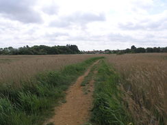
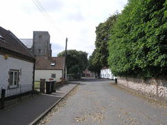
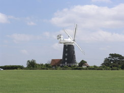
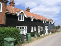
At TF719449 it curves to the right to start heading south-southeastwards along a path beside a floodbank. This soon curves to the left and then to the right; it heads south with a tidal creek on the left. It jinks to the left and then the right once more to head south before joining Staithe Lane at TF728438. Turn right to head south along the lane for a short distance; just before the short remaining stump of a windmill is reached on the left turn left to join a footpath. This heads eastwards before curving to the right and then the left; after a third of a mile it curves sharply to the right to head down to reach The Green in Thornham at TF733436.
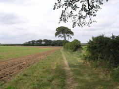
Turn left to head south down The Green for a fifth of a mile until it ends at a T-junction with the A149 road. Turn left to follow this road eastwards for a third of a mile before turning right up Choseley Road. Follow this south-southeastwards for 1.2 miles, and immediately before a small patch of woodland is reached turn left down a rough path. Initially the woodland is on the right, but this soon ends and the path continues on east-northeastwards. After two-thirds of a mile it crosses a road; continue past some barns on the right on for another third of a mile to cross another road. Head straight on along the track between hedges for 0.4 miles until a bend in the track is reached at TF769424.
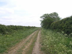
Follow the track around to the left as it continues northwards between hedges. After half a mile it jinks to the right and then the left to continue northwards. It soon curves to the right, becoming the surfaced Choseley Road which squeezes berween houses before ending at the B1153 Mill road; turn left to head north down this for a few yards until it ends at a crossroads with the A149 in Brancaster.
Carefully cross the A149 and head north along Broad Lane; when it curves to the left after a fifth of a mile turn right down a good path. Follow this eastwards along a boardwalk for a little over a mile; when the houses of Brancaster Staithe are met it turns to the right and then the left to meet a road. Turn right up this road towards a little area of stored boats; when the boats on the left end turn right down a path that heads between stored boats.
Continue along this path as it winds eastwards for three-quarters of a mile until it meets a track leading onto the marshes at TF803444. Turn right inland down this track for a few yards and then turn left to climb up onto a floodbank. This immediately curves to the left to head northeastwards. Stay on the flood bank as it slowly curves to take an easterly course. After two miles it jinks sharply to the right at TF834451 to head in a south-southeasterly direction. The flood bank slowly curves to the right before reaching the end of Overy Creek after 0.8 miles.
Turn left to follow the flood bank past the end of the creek. Do not turn left to follow the creek back out to the sea, but continue eastwards across a field towards the A149 road near a windmill. When it meets the road the path turns to the left, running with a hedge on the right, protecting you from the main road. When some houses are met after a sixth of a mile the path turns to the right through a gap in the hedge to join the road.
Turn left to follow the road northeastwards; there is a pavement on the left. Follow the main road as it curves to the right in Burnham Over Staithe and then turn left up West Harbour Way. This soon curves to the right to parallel the sea; as it curves to the right continue straight on down a path with a bank on the left. The path soon curves to the left to head northeastwards along the eastern bank of Overy Creek.
Follow the path as it runs along the top of the flood bank; it turns to the right and then the left to take a more northerly course and to enter an area of sand dunes. After 1.4 miles at TF857458 the path turns off to the right to head in a rough east-southeasterly direction with the bulk of the sand dunes on the right. It skirts to the north of a long area of woodland. After a couple of miles it turns to the right to head inland. It climbs up a bank with some trees on the left before descending and heading inland for a short distance to reach Holkham Gap at TF890447.
Just before the car park is reached turn sharply to the left along another footpath. Initially this heads northeastwards before slowly curving to the right to take a more easterly direction. After 1.4 miles it curves sharply to the right to head south, and then to the left to head northeastwards. After a quarter of a mile it curves to head eastwards to pass a lake on the right and goes through a gate to reach a car park. Head through the car park towards a building; pass this to reach Beach road at TF914455 with the car park on the right.
Cross the road and climb up onto a flood bank; turn right to head south along the top of the bank. After nearly a mile the path descends down from the flood bank to meet the road. Turn left to walk south down the road for a short distance with a flood wall on the left until the B1105 road is reached in Wells-next-the-Sea at TF915438.
 |
 |
|
Distances
| From | To | Distance (m) | Ascent (ft) | Descent (ft) |
|---|---|---|---|---|
| Hunstanton | Thornham | 6.4 | 161 | 151 |
| Thornham | Brancaster | 4.0 | 203 | 194 |
| Brancaster | Burnham Overy Staithe | 6.3 | 135 | 161 |
| Burnham Overy Staithe | Wells-next-the-Sea | 7.1 | 128 | 118 |
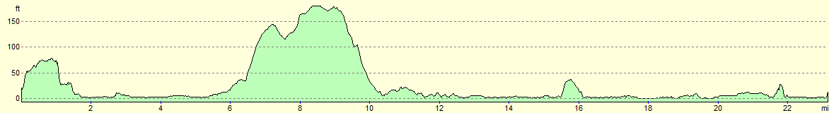
This makes a total distance of 23.8 miles, with 627 feet of ascent and 624 feet of descent.
For more information on profiles, ascents and descents, see this page
Accommodation
I spent the night at the West Runton Camping and Caravanning Club site. TThe facilities at the site were good, and as always with the camping and cravanning club sites, the toilets and showers were clean and tidy.
Transport
I used Norfolk Green's excellent Coasthopper service to get back from Wells-next-the-Sea to Hunstanton. This service runs regularly, especially in the summer.
 |
 |
|
 |
 |
|
 |
 |
|
 |
 |
|
 |
 |
|
 |
 |
|
 |
 |
|
 |
 |
|
 |
 |
|
 |
 |
|
 |
 |
|
 |
 |
|
 |
 |
|
 |
 |
|
 |
 |
|
 |
 |
|
 |
 |
|
 |
 |
|
 |
 |
|
 |
 |
|
 |
Disclaimer
Please note that I take no responsibility for anything that may happen when following these directions. If you intend to follow this route, then please use the relevant maps and check the route out before you go out. As always when walking, use common sense and you should be fine.
If you find any information on any of these routes that is inaccurate, or you wish to add anything, then please email me.
All images on this site are © of the author. Any reproduction, retransmissions, or republication of all or part of any document found on this site is expressly prohibited, unless the author has explicitly granted its prior written consent to so reproduce, retransmit, or republish the material. All other rights reserved.
Although this site includes links providing convenient direct access to other Internet sites, I do not endorse, approve, certify or make warranties or representations as to the accuracy of the information on these sites.
And finally, enjoy your walking!
Nearby walks
| # | Title | Walk length (miles) |
|---|---|---|
| 9 | Old Hunstanton and Holme | 4.0 |
| 133 | Hunstanton to Burnham Deepdale | 10.3 |
| 134 | Burnham Deepdale to Wells-Next-The-Sea | 9.5 |
|
|

|