Walk #809: A circular walk from Wimborne Minster
 |
 |
|
General Data
| Date Walked | 13/02/2008 |
| County | Dorset |
| Start Location | Wimborne Minster |
| End Location | Wimborne Minster |
| Start time | 08.23 |
| End time | 17.20 |
| Distance | 25.0 miles |
| Description | This was a very pleasant walk to the west and east of Wimborne Minster. |
| Pack | Today I carried my 30-litre Karrimor rucksack, filled with waterproofs, a book and other odds and ends. |
| Condition | I feel absolutely fine after this walk. |
| Weather | Today was a lovely, sunny day, with not many clouds in the sky. It was also fairly warm for the time of year. |
| OS map | Landranger number 195 (Bournemouth & Purbeck, Wimborne Minster & Ringwood) |
 |
 |
|
 |
 |
|
Map of the walk
Maps courtesy of Google Maps. Route for indicative purposes only, and may have been plotted after the walk. Please let me have comments on what you think of this new format. For a detailed table of timings for this walk, please see the table file.
 |
 |
|
 |
 |
|
Notes
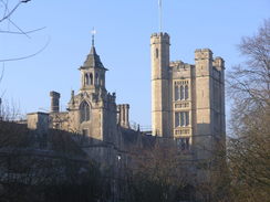
I was keen to do a walk today, so I set off early to drive down to Wimborne Minster. I had never been to the town before but it proved easy to find a large car park - my car sort of got sucked into it off the main road through the town. I put some money into the meter, got my gear together and set off. A footbridge took me over the small River Allen, and I headed through to the centre of the town. I stopped off at a shop to buy some crisps, and I munched these as I headed past the large Minster.
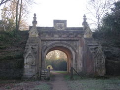
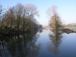
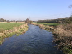
Roads took me southeastwards towards a bridge over the River Allen, from where there were some good views upstream. A little further on I headed off to the left, joining a path that passes some ornamental gates. A short distance further on I came across the first surprise of the day - a spectacular ornamental stone bridge that carried an old railway line over the path. There was a signboard nearby that denoted this as being the Lady Wimborne Bridge. It was in slight disrepair, but despite this was still majestic. The line above it closed in 1977.
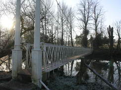
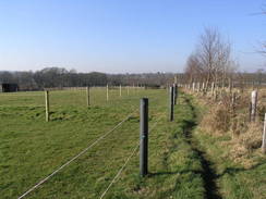
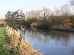
A little further on the path passed a boathouse and came to a narrow suspension bridge across the river. This was easy to cross, but an area of mud and water by a stile a little further on proved much harder. I managed to cross without getting my feet wet because the mud was slightly frozen. In places I got views across the river towards some ornate buildings; part of Canford School. The riverside walk was enjoyable, but it had to end and a road walk took me onwards to Stapehill. It was not a bad walk, but was an unpleasant contrast to the lovely walk along the riverside.
A road took me past the Uddens Trading Estate, and a track led on, crossing an old railway line and heading on to a bridge over the A31(T). The path soon entered the trees, and I was amused as a woman came running past, pushing an all-terrain pram with a baby! I was surprised to find a car park on Uddens Drive, and the path plunged back into the trees. I encountered the same woman again, this time coming towards me, near Uddens Water, and again we said hello.
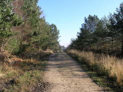
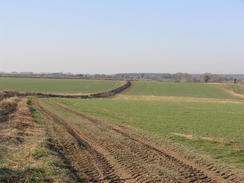
The path followed Uddens Water for a while before dumping me out unceremoniously onto a road in Ameysford. This met the walk that I had done further to the east earlier in the year, and I headed along a track that I had also walked, albeit in the other direction. I soon left my previous route, however, and started heading west following the Fewndown, Stour and Forest Trail, which crossed a very nice stretch of scrubland. It was a pleasant walk that ended all too soon at Clayford Farm, where large piles of sawdust were piled up alongside the track.
A boring track took me on beside White Sheet Plantation, and at the end of this I wanted to cut southwestwards across Uddens Park. Unfortunately I could not find the bridleway that easily on the ground, and I ended up heading too much to the west along another footpath. It was not too great a mistake, and I headed back along roads that passed through Broom Hill, before taking Long Lane southwestwards.
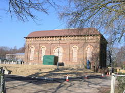
When the Horn Inn was reached I was fairly tired, so I decided to go in for a pint and a rest. I did not stay too long, but it was enough to recharge my batteries and I was soon striding along the rest of the road that led to the B3078 road. It was strange to think that I was now about half a mile north of my starting point in Wimborne Minster, yet had many miles still to walk. Past Long Close Farm there was a spectacular building up to the right, which looked like part of a water works. This was the highlight of a fairly nondescript walk that took me northwards across a series of fields, crossing the diminutive River Allen on a small bridge before climbing up past High Hall.
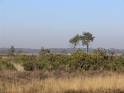
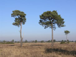
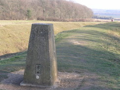
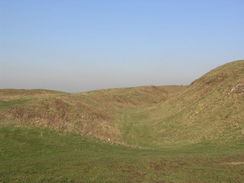
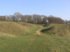
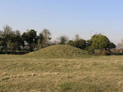
There was a long road walk westwards from here, and although there was virtually no traffic on the road I felt strangely uneasy. I put my Walkman on, but still I felt out of sorts. Things did not improve as the road ended and I took a track across King Down, and it was only when I climbed up to get my first sight of the spectacular Badbury Rings hill fort that I began to feel better. There were several rings of high ramparts, between which are deep ditches, and I clambered up one and followed the crest around to a trig pillar, from where there were some superb views to the north. It is a place that I wanted to explore further, but instead I continued around the rings and dropped down to another footpath that led down to the B3082 road.
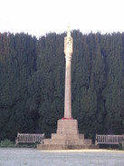
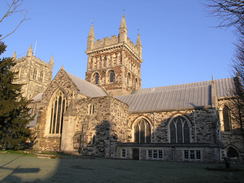
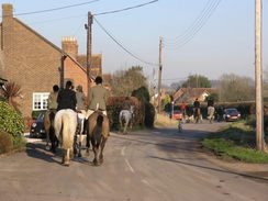
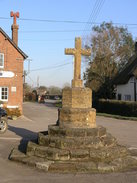
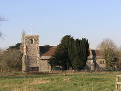
A long road walk led down to Shapwick, and in the centre of the village a hunt came streaming past. Usually when I come across hunts they seem slightly suspicious of me, but as usual after a quick 'hello!' they were friendly. I loved seeing the horses and the hounds, but before too long they had all streamed past me. There is an old cross in the centre of the small village, and a little further on I reached the lovely little church. Although small, it is certainly a pretty church.
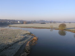
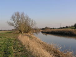
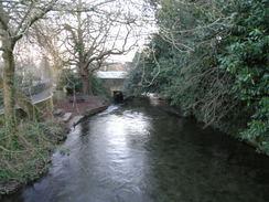
In Shapwick I joined the Stour Valley Way, which headed across the floodplains near the river before angling along away from the banks. It was a shame that it did not follow the river more closely, as some good views were surely missed. Eventually it rejoined the riverbank once more, and I listened to an EscapePod as the path joined the road near White Mill. Instead of following the Stour Valley Way as it headed in a little loop to the south of the road I continued along the road. It was getting late, and the walk was already plenty long enough without extending it further.
As I strolled I heard a car horn from behind and my adrenalin started pumping; I had been busy looking at my map, and had stumbled slightly into the path of a car driven by an elderly couple. My adrenalin was pumping and I felt cold; I said sorry to them and headed on, paying much more attention to the road this time. I wondered if a premonition of this is why I had felt so out of sorts immediately to the north of the point earlier in the day.
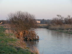
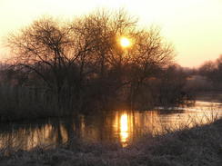
In Pamphill the Stour Valley Way headed off to the right, joining a riverside footpath that I could follow all of the way into Wimborne Minster. The sun was slowly sinking, and I stopped on a few occasions to take some photographs of a fairly spectacular red sky. After passing some allotments the river was left behind, and roads took me on into the centre of the town. There was one last task left to be done; I bought a Valentine's day card for tomorrow. By the time I reached the car there was only a little daylight left, and I could look back on what had been one of the longest walks that I have done for some time.
 |
 |
|
 |
 |
|
Directions
This walk starts off at the car park, just off the Allenview Road in Wimborne Minster. Leave the car park and cross a footbridge over the River Allen, and then turn left down a road for a short distance to the B3073 road. From here head south through the town, heading past the market square and the Minster to reach the B3073 Leigh Road. Turn left to head eastwards along this road as it cross the river once more, and then turn left down Poole Road. This road soon ends at the B3073; continue straight on southeastwards along this road. It curves to the right to take a more southerly course, crossing the River Stour (there is a pavement on the right-hand side). A few yards south of the bridge a footpath heads off to the left, the Stour Valley Way. Follow this footpath as it passes a gate and heads eastwards, soon reaching a grand bridge that carried an old railway line overhead. Shortly after this the path passes under the A31(T) road, and continues eastwards.
The path passes a boat house on the left, and immediately after this there is a footbridge over the river. Cross this footbridge, and on the other side turn right to start following the northern bank of the river northeastwards for a little over a mile until it ends at a road right beside the A311(T). Here turn right, and head eastwards towards Little Canford, and then turn to the left to head northwards along another road for a short distance to the B3073. Cross the road and head straight on across a short stub road until another road is reached to the east of the large roundabout on the A31(T).
Turn right to head eastwards along the road towards Stapehill for half a mile, and after a pub on the left turn to the left along a road that skirts the edge of an industrial estate. When the road curves to the right, continue straight on across an old railway line and turn half-left, to head westwards with the trees on the right until a bridge over the A31(T) is reached. Immediately on the other side of the bridge turn right down a track, to parallel the northern side of the main road. The track enters some trees, and shortly after this turn left down another track that heads northwestwards through the trees. After a hundred yards turn right, and join a path that heads northeastwards. This soon emerges from the trees, and passes a car park before crossing a road called Uddens Drive.
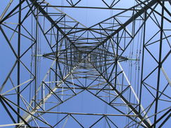
Cross this road and continue on eastwards on the other side along a track; this enters some woodland and angles back towards the main road. Take the first track off to the left, which heads northwards until the edge of the trees are reached. Here turn right, and follow a path that heads eastwards along the edge of the trees. After a short distance the path turns to the left, to head northeastwards, still just inside the trees. A little under half a mile after the bend there is a footbridge; cross this and turn half-right to head eastwards with Uddens Water on the right. Continue on for about three-quarters of a mile until some power lines are reached; here leave turn slightly to the right to emerge out onto a road in Ameysford.
Immediately turn to the left to start heading northeastwards, with power lines and a golf course on the right. The track soon curves to the left to head northwards for a third of a mile. When a T-junction is reached, turn left and start heading westwards along a track for half a mile until Clayford Farm is reached. Here turn right to head westwards along another track for three-quarters of a mile immediately to the south of White Sheet Plantation. When the western edge of the woods are reached, turn left down a footpath to head south for a short distance before turning to the right to head westwards through Staple Copse. The bridleway curves to head southwestwards; after a short distance, turn right along a footpath that heads westwards past Uddens Park. A diversion takes you around the edge of a paddock, before the path ends at a road.
Turn left to head southwestwards along the road for a short distance towards Broom Hill. Pass a crossroads and continue southwestwards for about a third of a mile until a road junction is reached on the right, with a pub immediately beyond it. Turn right along this road, called Long Lane, and follow it as it heads southwestwards for a little under a mile to another crossroads, Head straight across, and continue on along another road southwestwards for another mile until it ends at the B3078 road. Turn left down this road for a short distance, and then turn right to start heading along a track that leads towards Long Close Farm. Keep on the track as it passes the farm, and when an impressive water works building is reached on the right continue on along a rougher track.
Shortly after this turn right along a footpath that heads northeastwards uphill; when the edge of Catley Copse is reached, turn left to start following another footpath northwards. After half a mile it crosses the River Allen, and then climbs up a light hill to skirt to the east of High Hall and end at a road. Turn left along this road and start following it as it heads westwards for over a mile, ending at a complex junction of tracks on King Down. Turn half-right along a track to head northwestwards for a mile, passing Lambing Cottage on the right before reaching another junction in the tracks.
Here turn left, to start heading south of southwestwards for a mile, descending down to King Down Farm before climbing uphill once more. At a patch of woodland at the top of the hill turn right, and head westwards to the first of the ramparts of the Badbury Rings complex. From here head westwards to the car park at the western side of the fort; you can either walk around the rings to the north or south or cut straight across the middle.
At the car park turn left and follow a track that leads southwestwards down to the B3082 road. Cross this road, and continue on southwestwards for a mile and a half into the village of Shapwick. Pass the war memorial and follow a lane as it curves to the right towards the village church. Just before the church is reached, turn left to join the Stour Valley Way. This passes under some power lines to join the northern bank of the river; follow it southwards, and then on as it curves to the left to head eastwards.
A couple of miles after the church, the path approaches a road at White Mill. Join the road, and just before it curves down to the right to cross the river turn left up another road. This climbs up a little hill before curving to the right to head southeastwards. Follow this road for two and a half miles, as it takes a more easterly heading, passing through Cowgrove. When the river approaches again on the right, turn right and join the Stour Valley Path as it heads eastwards along the northern bank of the river.
The path passes through some allotments before joining a track that ends at the B3078 road just outside Wimborne Minster. Turn left along this road and follow it as it heads eastwards into the centre of the town. From the market square, retrace the steps of earlier in the day to get back to the car park and the start of the walk.
 |
 |
|
 |
 |
|
Distances
| From | To | Distance (m) | Ascent (ft) | Descent (ft) |
|---|---|---|---|---|
| Wimborne Minster | Ameysford | 6.5 | 164 | 171 |
| Ameysford | The Horns Inn | 4.4 | 171 | 62 |
| The Horns Inn | Shapwick | 7.9 | 429 | 515 |
| Shapwick | Wimborne Minster | 6.2 | 115 | 131 |
This makes a total distance of 25.0 miles, with 879 feet of ascent and 879 feet of descent.
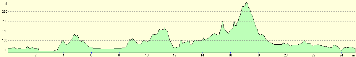
For more information on profiles, ascents and descents, see this page
 |
 |
|
 |
 |
|
 |
 |
|
 |
 |
|
 |
 |
|
 |
 |
|
Disclaimer
Please note that I take no responsibility for anything that may happen when following these directions. If you intend to follow this route, then please use the relevant maps and check the route out before you go out. As always when walking, use common sense and you should be fine.
If you find any information on any of these routes that is inaccurate, or you wish to add anything, then please email me.
All images on this site are © of the author. Any reproduction, retransmissions, or republication of all or part of any document found on this site is expressly prohibited, unless the author has explicitly granted its prior written consent to so reproduce, retransmit, or republish the material. All other rights reserved.
Although this site includes links providing convenient direct access to other Internet sites, I do not endorse, approve, certify or make warranties or representations as to the accuracy of the information on these sites.
And finally, enjoy your walking!
Nearby walks
| # | Title | Walk length (miles) |
|---|---|---|
| 312 | Southbourne to Hamworthy Station | 15.3 |
| 313 | Hamworthy Station to South Haven Point | 18.0 |
| 802 | A walk from Christchurch to Poole | 21.8 |
|
|

|