Walk #774: Royston to Cambridge
 |
 |
|
General Data
| Date Walked | 10/06/2007 |
| County | Hertfordshire, Cambridgeshire |
| Start Location | Royston |
| End Location | Cambridge railway station |
| Start time | 08.25 |
| End time | 16.49 |
| Distance | 24.1 miles |
| Description | This was a very pleasant walk following the Harcamlow Way as it heads north from Royston and then east into the centre of Cambridge. |
| Pack | Today I carried my 30-litre Karrimor rucksack, filled with waterproofs, a book and other odds and ends. |
| Condition | I feel absolutely fine after this walk, and could easily have walked further if I had had the time or need despite the distance walked. |
| Weather | The day started off with low cloud and a little drizzle in the air, but the cloud soon rose leaving a bright and sunny day with only a little breeze to help cool me down. |
| OS map | Landranger number 154 (Cambridge & Newmarket, Saffron Walden) or Explorer number 209 (Cambridge) |
 |
 |
|
 |
 |
|
Map of the walk
Maps courtesy of Google Maps. Route for indicative purposes only, and may have been plotted after the walk. Please let me have comments on what you think of this new format. For a detailed table of timings for this walk, please see the table file.
 |
 |
|
 |
Notes
I did not want to drive too far for today's walk, and so early this morning I sat down with Anquet and looked around the local area for walks that I had either not done before or had not done in a long time. Eventually I noticed that the Harcamlow Way - a 140-mile loop walk taking in Harlow and Cambridge - goes from near Royston to Cambridge, and after measuring it realised that it would make a good long day's walk.
the short journey to Royston from my flat south of Cambridge did not take too long, and once I arrived it took me a few minutes to find a ticket machine for the car park - it turned out that it was located in the upper car park and not in the lower one where I had parked. The ticket cost one pound for the day, although I was sure that a few years ago I could have parked in he station on a Sunday for free. On the other side of the station there were some coaches, and I was disappointed to discover that there were no train services running today and the coaches were running the bus replacement service. I really wanted to be able to get back in time this evening to watch the Canadian Grand Prix that started at six, and the slower replacement services made the timescales even tighter.
There had been a light drizzle on the drive to Royston, and although that had stopped by the time that I started walking there was low cloud hanging over the hills that surrounded the town. The first half-mile to the A505 was fairly uninteresting as the road passed a supermarket and a petrol station, although there was a milestone that seemed to be in fairly good condition beside the road.
Once across the A505 I was relieved to find that there was a pavement alongside the A1198 road as the traffic, despite not being heavy, was moving fast. Atone point I stepped into an adjoining grass field,and every move released clouds of dust and pollen off the grass stems, the light wind catching it and transporting it up into the sky. The pavement swapped over to the other side of the road and I then reached a track that carried the Ickield Way, and with relief I left the road and started walking eastwards along the track. The sun was starting to peek through the clouds overhead, and I started to feel glad that I had not worn a fleece when I had set out as I was already starting to feel warm.
The Icknield Way was only followed for a couple of minutes before I joined the Harcamlow Way, a path that I would be following all of the way into the centre of Cambridge. The route is 140 miles long, but there is very little on the Internet about it aside from a good site from a family. Given it's closeness to Cambridge I should really do it sometime. As I walked I was followed y a woman with a dog, and I kept my speed up in order to keep ahead of her as the path wound around, keeping on the field side of a series of houses and passing what is marked on the map as Kneesworth House Hospital.
A little further on the path passed a farm shop, and on the other side of the track opposite the shop there was a field with a couple of llamas in and, beyond them, a couple of people exercising on horses. After a short stretch of road the oath headed northwards once more towards Whaddon and it was a fairly pleasant if nondescript stretch, with some wide views all around curtailed by distant hedgerows.
In Whaddon the path suddenly took a westerly route across the south of the village, and I could see a couple of children playing in the golf course situated right in the centre of the village. A road was soon reached, and this was followed past the little village green and sign to head north through the village. Near the church I met a walk that I had done previously, when I had walked in the opposite direction as part of a circular walk from Orwell.
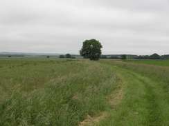
A track took me on northwestwards across a flat expanse of land that was nonetheless a surprisingly pleasant stroll. Ahead of me a band of trees was visible, and this marked the south to north line of Wimpole Avenue, a long avenue of trees leading directly from the hall. Once at the trees I followed the outside of the trees northwards, but after a short distance I came across a point where the track headed into the trees and continued on along the outside. After a few hundred yards the path petered out and I continued on for a short distance through a path of nettles and brambles beside the hedge before I eventually was forced to turn back and headed back to the track.
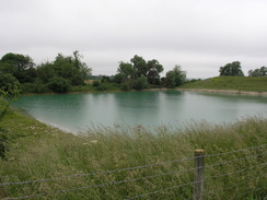
I was kicking myself as I entered the avenue and saw an indistinct track heading north through an area of long grass between some young trees. It was nice to be on a relatively clear path once again and I made good time as Mayflys fluttered around me from within the long grass. On the map an octagonal pond was marked within the middle of the avenue and the path was separated from this by a barbed wire fence; the pond, however, seemed to be covered in long reeds. Another stretch of long grass took me to across a series of rickety stiles and an overgrown meadow to reach what once would have been a very elegant brick bridge over the River Cam, which had definitely seen better days. In the Second World Wat the avenue had been used to store bombers from the Bassingbourn airfield at its southern end.
Once across the bridge the going was easier as the path headed due north, crossing the A603 and heading north, still along the avenue with some grand views visible towards the hall. It would have been simple for the path to continue straight on towards the hall, but instead it took a sharp jink to the left to head westwards across fields back to the A1198 for the last time in the day. The road took me on into Arrington, and although the hotel looked as though it was open I decided to continue on towards the massively imposing gates that led into the grounds of Wimpole Hall, with one stone column topped with a lion and the other a Unicorn.
Inside the gateway a track led on through parkland towards the hall, but after a few yards there was a noticeboard stating that the area in front was, during the Second World War, a massive American field hospital. The parkland in front seemed as though it had been in its present form for Centuries, and it was hard to believe that it was once full of buildings; apparently the only remaining trace of it are the names of American soldiers and airmen engraved into the trunks of trees.
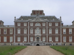
The track was relatively busy, and I strode along it wishing that the path took the direct route straight up the avenue towards the hall instead of taking the direct route to Arrington. The path headed a short distance in front of the hall and there are some good views of the superb building, and then headed towards the old stable block, which are grand enough to be a hall in themselves. The adjacent car park was filling up but the overflow car park was empty, and I strode on down the driveway to join the road that led up the long wooden barns at Home Farm.
Another track took me uphill past some woodland to reach Mare Way, a track that runs along the top of the ridge. On the track to my right there were a couple of cars and a large mast, which I assume were radio enthusiasts attempting to see how far they could get a signal to reach. At the junction of the tracks there is a reservoir and a half-buried trig pillar, and a family including a pram that was being pushed along the rough ground. The reservoir marked the point that I had joined the path on my previous walk, and from now on until the very end of the day I would be in virgin territory. The ground got increasingly rough as the track headed westwards, eventually heading through a small patch of woodland before reaching a road.
At New Farm the Harcamlow Way headed northwards along a bridleway, always keeping a hedge to the right. The views were sometimes reasonable as the path slowly lost in height, and it was a very unusual stretch; a bridleway on one side of the hedge and a footpath on the other, leading me to wonder why one or the other had never been closed. Some roads took me through the little village of Kingston before the B1046 was joined for a short distance; the road was quiet but there was no pavement, and I was glad that I did not have to remain on it for too long.
Another road took me across a bridge over the old Cambridge to Oxford railway line, and the cutting underneath was clogged with trees making any photographs of the old formation pointless. A nice climb uphill followed, passing the church on the right, but unfortunately the sun was in the wrong position to get a good photograph of it. After the gradient slackened a red phone box was reached, and immediately before this another bridleway led off to the right before turning to head northwards. By this stage of the day it was getting quite warm and I had not yet had a stop, but I was feeling fit and decided to continue on towards a pub that I had visited before in Hardwick, although I was unsure if it would be open.
The bridleway skirted the western side of the scrubby Hardwick Wood before turning to head eastwards across open fields, a walk that was pleasant enough, but by this stage I was in need of a rest given that I still have six miles to go, and so when a road immediately to the south of Hardwick was reached I turned down the road to visit the pub. This was as pleasant as I remembered it and was not too busy on this Sunday afternoon, so I went inside to get my obligatory two pints before heading outside to sit under the large sunshade.
Although my feet were not hurting me I opted to take my boots off in order to let my feet breathe a little as they were very hot, only to discover that my socks were covered in grass seed and various other bits of vegetation that had obviously attached itself to me as I had walked. Some of the seed were well ensconced inside the two layers of the 1,000 mile socks, and I spent ten minutes getting all of the seeds out from where their entanglement.
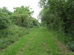
Before I set off I chatted to a couple of men with Irish accents about walking, and they seemed interested in what I was doing and where I was walking from. It is nice to be able to chat to people on the walks, but I could not stay too long and instead hauled myself back up the road to rejoin the Harcamlow Way. This continued on eastwards along a track called the Port Way, and as I walked I was passed by a horse and rider who asked me some directions. In a small area of woodland I passed a jogger who seemed almost fit to drop, and a short distance further on I reached Long Road.
The track headed along Long Road for a short distance before turning off to join another track that skirted the northern edge of a military shooting range. I had cycled along this path years ago, and it amazed me how pristine the range looked; if it were not for the ominous warning signs it would be impossible to tell it apart from the surrounding fields and hedges. The track took me on into Coton and there were some reasonable views over Cambridge to be had on the descent, but before I knew it I was passing the church and the pub, which had shut for the afternoon, before heading on towards the bridge over the M11.
As I was nearing Cambridge I was starting to get anxious about the time, and I really wanted to be able to get back home in time to watch the Grand Prix. I therefore motored along the cycle path on the eastern side of the motorway, and enjoyed the walk as it went past various large buildings housing parts of the University. The area became more urban and a road was joined for a while, but when this was left an absolutely superb track tool me on deeper towards the city centre, crossing the inner ring road before reaching a pedestrian bridge over the Cam.
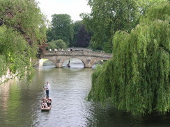
From here I was on very familiar territory, and Sencan phoned as I passed through the narrow streets that led past the colleges towards the main part of town. The tall, dark buildings looked wonderful in the sunshine, but I was in too much of a hurry as I pressed on, heading through the city and trying to avoid the huddled masses that were still in the city at this late time on a Sunday afternoon.
Cambridge bus station is usually bustling during the week, but on this Sunday it was deathly quiet and I realised that I would have to walk the mile to the railway station. This was no great hardship as I was feeling fine, but it did mean that time was getting short. My route took me past the Catholic cathedral and on towards the imposing war memorial, before heading off down another road towards the station. As I walked the last couple of hundred yards one of the train substitute services for Royston passed me, and that meant that I would have another forty minutes to wait for the next one.
I therefore took my time getting my ticket and discovered to my horror that the journey, which should be twenty minutes by train, was going to take nearly an hour on the substitute service! After buying a magazine to read I sat down on some steps outside and read, and what followed was a hot and stuffy journey back to my car in Royston on a coach, the only positive side of which was the running commentary that the coach driver gave me. I eventually got in twenty minutes after the start of the race, but I had not missed any of the important bits of what turned out to be a very exciting race, and I could look back on what had been an exceedingly enjoyable walk in an area that I had thought held no new walks for me.
Directions
This walks starts at Royston railway station. Leave the station and head up the approach ramp to reach the Old North Road. Here turn to the left to start heading northwards; this passes a roundabout by a Tesco store before continuing on for another hundred yards until a large roundabout on the A505 is reached.
Carefully cross the roundabout and head north along the A1198 road for a mile; there is a pavement on the left-hand side of the road for most of the way. A large area of greenhouses are reached on the right, here the pavement swaps over to the right-hand side of the road and follow it for a short distance until a track leads off to the right carrying the Icknield Way.
Follow the Icknield Way eastwards for a couple of hundred yards; after the greenhouses end on the right a footpath leads off to the left, carrying the Harcamlow Way, which will be followed all of the way to Cambridge. Initially the Icknield Way heads north along a hedge, before starting to wind around the outside of Kneesworth House Hospital, always staying on the right-hand side of the hedges and not going into the grounds.
Once past the house the path goes through a hedge and immediately turns to the left to follow the hedge westwards for a hundred yards before turning to the right to follow a hedge on the left northwestwards. This path soon meets a track and passes a farm shop before ending at Chestnut Lane to the east of Bassingbourn.
Turn left down the road for a few yards to head towards the A1198; just before a minor road leads off to the right cross a stile to the right and start following a hedge northeastwards. A track is crossed, and when a large mound next to a lake is reached skirt to the right of the mound and continue on in a rough northeasterly direction. The path passes a house through a hegde on the left before reaching a crossroads in two tracks. Turn left, and follow the track northwards as it crosses a stream to reach the end of a road.
Continue north along the road for a few yards and then turn right, following a footpath that follows a track into Fountain Farm. The path passes the farm and then heads out, keeping a hedge to the left as it slowly curves for about half a mile from a northeasterly to a northerly course to reach a road in Whaddon. Do not join the road, but immediately turn to the left to take another footpath that heads southwestwards, keeping a hedge roughly to the right as it crosses a small field that slowlt becomes narrower before ending at a bend in a road.
Here head straight on westwards for a few yards until the road ends at a larger road near the village sign and turn right, to start following the new road northwards. The road soon curves slightly to the left, but when it then curves sharply to the right to head towards the church head straight on along a track, still following the Harcamlow Way as it heads northwestwards for a mile.
The track ends by an area of trees that marks the eastern side of Wimpole Avenue. Here turn right and follow a footpath northwards with the trees on the left; when a track through the trees is reached after a few yards turn left to enter the avenue and then turn immediately right to start heading north inside the avenue. The path skirts to the right-hand side of a little lake (now only a patch of weeds), and on the northern side heads towards a bridge over the River Cam. Note that the path crosses three stiles and a patch of scrubby wasteland to get to the bridge; it may be easier to cross the first stile and turn left to follow a fence around to the bridge.
Once across the small bridge continue northwards up the avenue, keeping to the right-hand (eastern) side of the avenue until the A603 is reached. Cross this road and continue on northwards along the footpath up the avenue for another half mile. When the path is level with a farm on the right turn left along a footpath that leaves the farm, crossing the avenue and then heading westwards for a few yards to cross a stream. Once across the stream the path turns to head northwestwards for half a mile to reach the A1198 road.
Turn right to head north along the A1198 through Arrington, passing a pub on the right and then, shortly after a road comes on from the left, there is a large and imposing pair of gates on the right. Turn right and head through the gates, and follow a track that heads northeastwards as it winds through Wimpole Park to skirt immediately to the south of the hall. Continue along the track as it heads slightly north of eastwards along the track, passing the imposing old stable block and the large car park before heading on across the parkland to end at a road. Here turn left along the road for a few yards until Home Farm is reached.
At Home Farm turn right to join a track that heads northeastwards for about a hundred yards before curving to he left and crossing a stream to reach Cobb's Wood Farm. Continue on along the track as it starts to climb uphill, passing an area of woodland as it ascends. When the track curves to the right continue straight on a long a path through a little patch of woodland and then turn left to reach a track that runs along the top of the ridge.
Turn left and follow the track westwards for a little over a kilometre as it becomes rougher underfoot and eventually enters an area of woodland for a short distance before ending at a road. Continue straight on along this road northwestwards for a hundred yards past New Farm, and then immediately turn right to join a track called Crane's Lane.
Stay on Crane's Lane as it heads northwards and then northeastwards for about a mile and a half, eventually dropping downhill slightly to join the end of a road in Kingston. Head down this road for about fifty yards until it ends at a T-junction with another road, and then turn left along another road. This heads through the centre of the village in a rough northerly direction, slowly dropping downhill before ending at a T-junction with the B1046.
Turn left and carefully walk along the B1046 for a short distance before turning right up another road, which crosses a bridge over an old railway line before heading uphill. It passes the church and, after about a kilometre, a bridleway leads off to the right just before a red phone box. Follow this bridleway as it heads eastwards for a couple of hundred yards; when it reaches a band of trees turn left and keep on the bridleway as it heads northwards. An area of woodland soon starts on the right; when this ends continue on northwards for about fifty yards with some gardens to the left, until the bridleway jinks sharply to the right.
Continue along the bridleway as it heads eastwards across open fields for about three-quarters of a mile until it meets a road. Here I turned left foe about a hundred yards to visit the pub in Hardwick; if you do not want to visit the pub, turn left for a few yards and then turn right to rejoin the bridleway as it continue eastwards. After a kilometre a band of trees is reached; the bridleway turns to the left to had northwards through the trees for fifty yards before turning to the right to continue eastwards for half a mile until the bridleway ends at Long Road.
Turn left and head north along Long Road for about a hundred yards as it descends to a stream and then climbs up the other side. When a bridleway is reached on the right join it and follow it as it heads eastwards, soon breaking out of a band of trees as it follows a track with a military shooting range to the right. After about a mile the track ends at a road to the west of Coton; join the road and follow it as it heads eastwards through the village, passing the church before ending at a T-junction with another road. Turn right and follow this road as it soon curves to the left to approach another pub, and here walk straight on along another road as the former road curves sharply to the right.
Follow this road as it heads eastwards past a recreation ground on the right; the road soon ends on the outskirts of Coton but a good surfaced cycle path continues on to reach the M11. The path then turns sharply to the left and then right to reach a bridge over the motorway; on the other side of the bridge turn right and continue following the cycle path as it heads eastwards, occasionally jinking but always resuming the easterly course.
As the path passes the Cavendish Laboratory it becomes busier, and when it ends at a road continue straight on along it eastwards. Continue on along the cycle path as it crosses another couple of roads and finally crosses the A1134, part of the ring road around Cambridge. Cross this road and continue on along a causeway to reach a bridge over the River Cam.
Cross this bridge and continue on until the lane ends at a T-junction. Turn left and then almost immediately right, following another narrow lane between high buildings that soon ends at another road. Turn left and then right to head down Green Street until it ends at yet another T-junction. Turn right and follow this road through the centre of Cambridge; it passes the bus station and then reaches a war memorial. Here turn left and walk eastwards along Station Approach to the railway station, where this walk ends.
Distances
| From | To | Distance (m) | Ascent (ft) | Descent (ft) |
|---|---|---|---|---|
| Royston station | Wimpole Hall | 9.1 | 144 | 203 |
| Wimpole Hall | Hardwick pub | 8.0 | 331 | 259 |
| Hardwick pub | Cambridge bus station | 6.0 | 59 | 226 |
| Cambridge bus station | Cambridge railway station | 1.0 | 0 | 16 |
This makes a total distance of 24.1 miles, with 534 feet of ascent and 704 feet of descent.
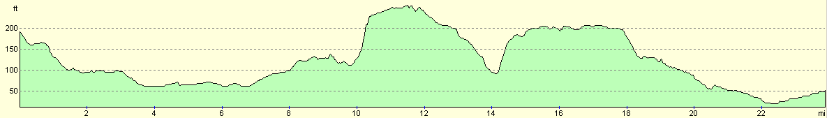
For more information on profiles, ascents and descents, see this page
Transport
There are regular train services (often two an hour) between Cambridge and Royston.
Disclaimer
Please note that I take no responsibility for anything that may happen when following these directions. If you intend to follow this route, then please use the relevant maps and check the route out before you go out. As always when walking, use common sense and you should be fine.
If you find any information on any of these routes that is inaccurate, or you wish to add anything, then please email me.
All images on this site are © of the author. Any reproduction, retransmissions, or republication of all or part of any document found on this site is expressly prohibited, unless the author has explicitly granted its prior written consent to so reproduce, retransmit, or republish the material. All other rights reserved.
Although this site includes links providing convenient direct access to other Internet sites, I do not endorse, approve, certify or make warranties or representations as to the accuracy of the information on these sites.
And finally, enjoy your walking!
Nearby walks
| # | Title | Walk length (miles) |
|---|---|---|
| 2 | Waterbeach to Newmarket Road, Cambridge | 5.4 |
| 5 | A short walk around Waterbeach to Car Dyke | 3.0 |
| 6 | Waterbeach to Newmarket Road, Cambridge | 5.4 |
|
|

|