Walk #775: Merthyr Tydfil to Treforest
 |
 |
|
General Data
| Date Walked | 06/07/2007 |
| County | Mid Glamorgan |
| Start Location | Merthyr Tydfil Railway Station |
| End Location | Treforest Industrial Estate station |
| Start time | 11.08 |
| End time | 17.15 |
| Distance | 17.5 miles |
| Description | This was a pleasant walk following the Taff Trail southwards from Merthyr Tydfil. |
| Pack | Today I carried my 30-litre Karrimor rucksack, filled with waterproofs, a book and other odds and ends. |
| Condition | My feet are really aching after this walk, but aside from this I have no significant problems. |
| Weather | today was a mixture of sunshine and clooud, and there was not muc breeze to keep me cool on what was a warm day. |
| OS map | Landranger number 160 (Brecon Beacons), Landranger number 170 (Vale of Glamorgan, Rhondda & Porthcawl) and Landranger number 171 (Cardiff & Newport, Pontypool) |
 |
 |
|
 |
 |
|
Map of the walk
Maps courtesy of Google Maps. Route for indicative purposes only, and may have been plotted after the walk. Please let me have comments on what you think of this new format. For a detailed table of timings for this walk, please see the table file.
 |
 |
|
 |
Notes
I had planned to have three days off work to go walking, mainly in order to complete walks on a couple of the dates that I have yet to walk on. Three days were not really enough to do any of the trails that I wanted to do, so I dusted off plans to walk in South Wales and booked a campsite to the north of Merthyr Tydfil. This morning I set off early for the long drive westwards; this was not too long or harrowing, but despite the early start it was still late in the morning by the time I pulled off the main road and descended into the centre of Merthyr Tydfil.
My first problem was where to park. I had completed a walk from Brecon five years earlier and the entire area had changed from my memory, with a large Tesco superstore having been built right by the station (there is a chance that it was there when I had been here in 2001, but have forgotten about it). The car park at the superstore would not allow me to park all day, and a couple of other car parks were short-stay only, and the next one I tried just uphill from the station was long stay but full. Fortunately I was in luck, and just as I was turning round to exit the strip car park a couple of motorcyclists turned up and I managed to get in their slot with some difficulty.
As I had been sitting down all morning I ensured that I did some stretches as I got my kit together, and walked slowly down towards the station. It was tempting to nip into the Tescos to buy some provisions, but instead I walked on to the station to start the walk.
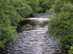
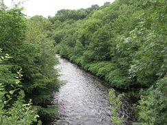
The purpose of this walk was to connect Merthyr Tydfil to Cardiff using the Taff Trail, although the distance was too great for me to do in one day. It proved easy to find the bridge over the river and the Taf Trail, and I started following the trail southwards along the western bank of the river. Initially there were signs of old railways in the area; the path climbed up onto an old railway embankment for a period before dropping down to pass under a large bridge.
Underfoot there was tarmac, and as the path continued southwards I was annoyed to find that this was continuing to be the case as I was wearing my boots and my feet were soon starting to get tired. The path continued on, passing a pub as it entered the outskirts of Pentrebach, sometimes running on quiet roads and at others on paths. Nearby the busy A470(T) main road was audible but rarely visible, and south of the village a spur road passed overhead on a high bridge.
To the east on the other side of the valley there were high hills with some pleasant-looking crags, and I wondered how different the skyline and views would have looked forty years before at the height of the mining and industry in this Welsh valley. The thoughts entertained me as I followed the path southwards, although aside from this the Taf Trail was proving to be fairly boring, with a pedestrian path underfoot. The path passed through Aberfan, site of the mining disaster in 1966 when a colliery spoil heap slumped into the town, covering a school and killing 144 people. As I understand it the great terrible mass of coal waste would have passed over the railway embankment that I was walking along, an extremely sobering thought.
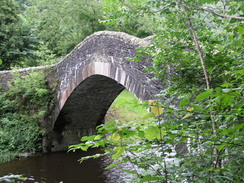
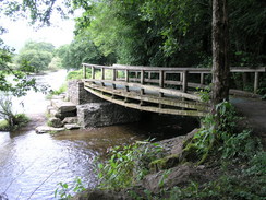
The path got worse as the path headed steeply uphill along a track to pass under the A470(T), before turning to follow the western side of the road downhill. This was a noisy and unpleasant stretch, with trees and woodland to the right and the main road plunging down to the left. It was therefore a relief after about a mile when the track plunged back under the road and headed down a rough, rutted track to reach a beautiful hump-backed bridge over the Taf.
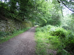
On the other side of the bridge a surfaced road headed uphill steeply, before the Trail headed off to the right along a track. This was a much better walk through woods, and at a couple of points there were the remains of old railway abutments high overhead, part of the arch springing still in place. These viaducts must have been magnificent when they were in place, striding high over the river. Despite the fact that we were essentially in a town the area was quiet and secluded as it headed along a wide loop in the river.
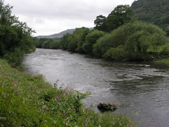
The path crossed the river on a small bridge once and continued on before crossing it once again, to continue heading southwards along the eastern bank of the river. Occasionally there were some good views to be had as a road was followed, and suddenly a large road viaduct passed overhead. This was actually two separate bridge built side-by-side; stretched between them was some netting that was filled with rubbish that had been thrown out of cars.
In Abercynon a road was joined, which crossed over the dual carriageway before heading south. It was not a particularly pleasant walk, and it was a relief when the the trail recrossed the dual carriageway on a bridge and entered a little industrial estate. The rest of the path south into Pontyprid was pleasant enough as it skirted the river before eventually entering the town. This seemed to me to be an archetypal Welsh Valley village, with close rows of stone houses set below a steep hillside.
In Pontypridd the path followed roads back to the A470(T) dual carriageway and across it at a not particularly pleasant roundabout. Here I left the official route slightly and climbed uphill along a steep road, before joining another road that headed back to the Taf Trail. This road ended by a large cemetery, and I was disheartened to find that the path past this was closed. For a moment I considered getting past the barriers, but I could see further on that the path was essentially blocked by fallen fencing panels.
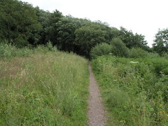
Not wanting to turn back I pressed on through the cemetery, looking at some of the impressive and pretty memorials before asking a workman about the path. He told me that it was closed to allow it to be converted into a cycle path, and that I could get out on the other side of the cemetery. This proved to be the case, and soon I was heading south once more along another old railway embankment. My feet had really been suffering under the hard surfaces that I had been walking on all day, and I could hardly wait for the walk to end as I walked on along the old line.
Eventually I reached the point where I would drop down to Upper Boat, and I was alarmed to see that the embankment was well above the road that I needed to be on, and separated from it by some rough, overgrown land. I plodded on, and was relieved to find a path that angled away down the slope to reach a road, from where I could access the roundabout near a superstore.
Upper Boat was a short walk further on, and although the pub was tempting I crossed the river and continued on, climbing uphill slightly and crossing an old railway bridge before following a narrow road to Treforest Station. I arrived in time for the train that I had wanted to catch, but the train was late and I therefore arrived back at Merthyr Tydfil station later than I had wanted. I had not taken any food with me on the trip, so I nipped into the Tesco store by the station to buy some food before starting the drive up to the campsite that I had booked myself into.
This proved easy to find, and was in a pleasant location near the Llwyn-on Reservoir. After booking myself in with the owner I drove across the wet grass to the spot that I had been allocated, and with tired legs slowly put my tent up. To my left were other campers with tents that dwarfed my Westwind tent, and we chatted for a while as it started to spit with rain. I was too tired to drive anywhere for a meal, and instead I tucked into some of the snacks that I had bought and read as I waited for it to get dark. The day had very much been a positional walk, one done to connect up other walks, but despite this it had been an interesting and thought-provoking stroll.
On another note, Wikipedia refers to 'Trefforest', while the OS maps refer to 'Treforest', with only one 'f'. I have no idea which is correct, but please accept my appologies for using the two spellings interchangeably.
Directions
This walk follows the Taff Trail from Merthyr Tydfil south to Treforest in Upper Boat. For most of the way the path follows an old railway line, an dis well signposted and easy to follow, even when it diverts off the line in Pontypridd and near Cilfynydd.
I started the walk at Merthyr Tydfil station, which meant I had to join the taff Trail. Leave the station and join the A4102, and follow it southwards to a roundabout. Carefully cross this, and then follow the signposts to a bridge over the River Taff. Ont he other side of this turn left to join the Taff Trail.
Follow this southwards for about 16 miles. At ST106875 near Upper Boat leave the trail, and walk down to a nearby road by a supermaket, Follow this road southwards until it reaches a large roundabout under the A47(T). Take a minor road, Gwaelod-Y-Garth Road, as it crossed the River Taff and then heads southwestwards. After a short distance the road curves to the left to head southeastwards. Trefforest railway station is a short distance away down this road.
Distances
| From | To | Distance (m) | Ascent (ft) | Descent (ft) |
|---|---|---|---|---|
| Merthyr Tydfil Railway Station | Aberfan | 4.3 | 318 | 364 |
| Aberfan | Quakers Yard | 4.0 | 640 | 804 |
| Quakers Yard | Pontypridd | 5.1 | 466 | 594 |
| Pontypridd | Treforest Industrial Estate station | 4.1 | 469 | 541 |
This makes a total distance of 17.5 miles, with 1893 feet of ascent and 2303 feet of descent.
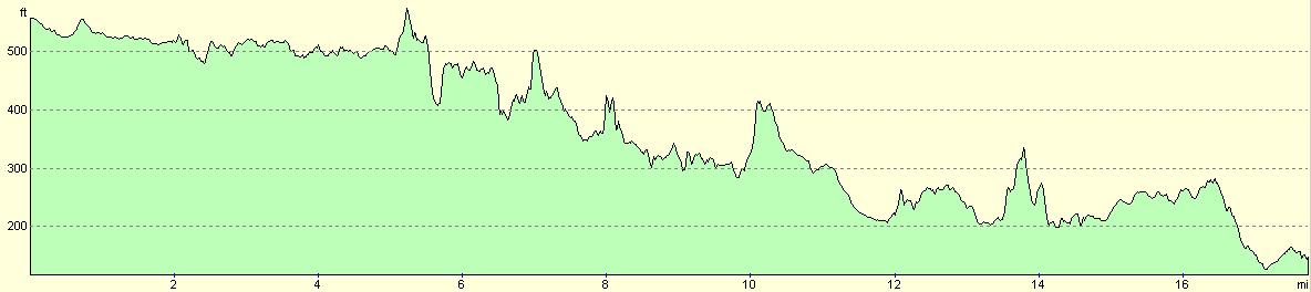
For more information on profiles, ascents and descents, see this page
Transport
There are fairly regular trains from Treforest Industrial Estate station back to Merthy Tydfil, changing at Pontypridd on the way. Note that Treforest Industrial Estate station is shut on Sundays.
Accommodation
I spent the night at the campsite at Grawen Farm, Cwm Taf, Merthyr Tydfil, Mid Glamorgan CF48 2HS, phone (01685) 723740. This was a very nice campsite situated ideally for the Brecon Beacons and the Welsh Valleys - highly recommended.
Disclaimer
Please note that I take no responsibility for anything that may happen when following these directions. If you intend to follow this route, then please use the relevant maps and check the route out before you go out. As always when walking, use common sense and you should be fine.
If you find any information on any of these routes that is inaccurate, or you wish to add anything, then please email me.
All images on this site are © of the author. Any reproduction, retransmissions, or republication of all or part of any document found on this site is expressly prohibited, unless the author has explicitly granted its prior written consent to so reproduce, retransmit, or republish the material. All other rights reserved.
Although this site includes links providing convenient direct access to other Internet sites, I do not endorse, approve, certify or make warranties or representations as to the accuracy of the information on these sites.
And finally, enjoy your walking!
Nearby walks
| # | Title | Walk length (miles) |
|---|---|---|
| 173 | Cwmcynwyn to Pontsticill via Pen y Fan | 11.5 |
| 174 | Pontsticill to Merthyr Tydfil | 6.0 |
|
|

|