Walk #638: A circular from Ashbourne to Tissington and Shirley
 |
 |
|
General Data
| Date Walked | 26/12/2004 |
| County | Derbyshire |
| Start Location | Ashbourne bus station |
| End Location | Ashbourne bus station |
| Start time | 08.08 |
| End time | 14.39 |
| Distance | 18.6 miles |
| Description | This was a nice and varied walk, taking in part of the Tissington Trail and Bonnie Price Charlie Walk, through a snow-filled winter wonderland. |
| Pack | Today I carried my 30-litre Karrimor HotRock rucksack, which was filled with three litres of water, a spare fleece, waterproofs and various electronic gadgets. |
| Condition | I feel absolutely fine after this walk, and I could easily have walked further if I had needed to. For the first time in ages I had absolutely no problem with the underside of my feet; whether this was due to the cold or the fact I wore two pairs of socks I do not know. |
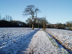
| Weather | There was a significant snowfall yesterday and overnight, and much of this was still on the ground this morning. It was a sunny day, with scarcely any clouds in the sky, although it was consequently bitterly cold when I was exposed to the slight breeze. |
| OS map | Landranger number 119 (Buxton & Matlock, Bakewell & Dove Dale) |
 |
 |
|
 |
 |
|
Map of the walk
Maps courtesy of Google Maps. Route for indicative purposes only, and may have been plotted after the walk. Please let me have comments on what you think of this new format. For a detailed table of timings for this walk, please see the table file.
Notes
After rather over-indulging with food during yesterday's Christmas festivities, I was rather in need of burning off the excesses. It had snowed on Christmas Day, and whilst this was wonderful for my nephew and nieces, it was less wonderful for someone planning a drive into the Peak District. The roads had been gritted as I made my way in the dark towards Ashbourne, but when I reached the town I really did not fancy driving nay further as I was quite tired and would be more so for the drive back after the walk. For this reason I parked the car at some free car parking spaces immediately outside the town and got my maps out to plan a walk and wait for it to get a little lighter. After a little perusal of the maps I settled on a circular walk based on the town, taking in some areas that I had not done much walking in before.
My first task was to walk to the bus station in the centre of town, where I had finished a previous walk. This was easy to do, and I started the walk in high spirits as I walked through the short distance through near-deserted streets towards the leisure centre at the old Ashbourne to Buxton railway line. This has now been converted into a long-distance cycle path, the Tissington Trail, and although this used to start immediately north of the town in 2000 it had been extended into the city centre by re-opening the old Ashbourne Tunnel. I entered this and enjoyed my walk through it, looking at the brickwork as I walked along. The tunnel (and indeed all structures on the line) had been built to double-track width, but low traffic had meant that it had only ever been single track.
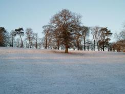
Although it is only 350 metres long it was noticeably lighter when I reached the northern end of the tunnel and passed a little car park and a bike hire shop that was shut. I plodded on northwards along the trail, enjoying the crunching sound that my boots were making in the virgin snow. It was a really relaxing walk, and I found that I could switch myself off as I plodded along and admire the views of the snow-covered hillsides that surrounded me. In seemingly no time I found myself crossing the A515 on a bridge and entering the sire of Tissington Station, where I had started a walk earlier in the year. There were a few people getting ready to start walking, and as I wanted to be on my own I increased my speed for the next few hundred yards until I reached another footpath.
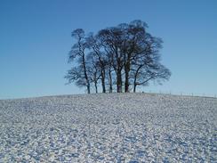
Her I bade farewell to the Tissington Station, and joined a footpath that headed southeastwards towards Bent Farm. On the way the path skirted Wibben Hill, and I could not resist the temptation to climb up and visit the trig pillar that lay on the top. The views of the snow-covered hillsides from the pillar were engrossing, and I took a series of photographs that will hopefully convert into a good panoramic photo. Eventually I managed to pull myself away from the view and started following the road eastwards down towards the B5056; towards the end the road was quite steep and slippy with ice, so I took my time reaching the ford at the bottom. Here the road crosses the Bradbourne Brook, and fortunately I did not have to wade through the water, as there is a footbridge a few yards upstream. My dad an uncle got a car stuck in the ford in the sixties, and he still has a photo of the car standing in the middle of the water.
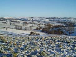
On the other side of the B5056 I took a lane that head steeply uphill, before diverting off along a bridleway that skirted to the south of Wigber Low. After crossing a road another bridleway took me onto a very slippy road, which I followed southeastwards to the B5035 to the northeast of Kniveton. Another road led shortly to a track that headed south over Madge Hill, and I diverted into a field beside the track to visit a trig pillar. The views from the pillar were very nice, but unfortunately the low sun blocked me from taking photographs of the best views. Several of the Trent Valley power stations were visible to the south, and the snow-covered landscape was superb. From the pillar the track continued on southwards, becoming a road beside a farm at Woodhead. This road dipped down to cross the Henmore Brook before reaching the A517 Ashbourne to Belper road.
Unfortunately the only route I could find south from here involved more road walking, but this was not too bad as the roads were quite quiet. On the map there is a place called 'Hole in the Wall'; when I reached there the reason for the name became obvious; the road passes straight through the middle of the farm building! It was a strange sight, and I enjoyed looking at the building and wondering how many vehicles had crashed into the narrow opening. There was not much more to note as I headed south along more roads towards the A52, and I started singing along to songs playing on my Walkman. I had to walk along a pavement beside the A52 for a short distance before taking another road that headed south across Shirley Common to the village of the same name.
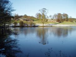
I diverted off route to take a couple of photos of Shirley Church, and then joined the Bonnie Prince Charlie Walk, which I would follow all the way back to the centre of Ashbourne. The Walk followed a track through Shirley Park, and the numbers of walkers became more numerous as the rough track descended down to meet a lake in Osmaston Park. This was quite a picturesque sight in the snow, and I watched a couple of swans on the water for a few minutes before starting the climb up through the parkland to reach the village of Osmaston. This is a lovely little village and I studied the architecture of the thatched houses as I walked past them. The pub in the village is called 'The Shoulder of Mutton', and is quite unusual, as it does not have a pub signboard outside it.
Osmaston Church was also quite nice, and I took a few photographs of this before heading on along the road. The Walk soon leaves this road, and starts crossing fields northwestwards. In an area of woodland there were some brick and concrete building bases that were almost completely concealed by vegetation, and these left me wondering what they were. They gave me the impression of being part of a Second World War camp, but I have no idea if that was just my imagination working overtime. The path eventually descended down to the A52, and I crossed this before joining a series of roads that passed through housing estates to the south of Ashbourne.
The path left the road at the top of the final hill, and I followed a footpath across a field before starting the descent down into Ashbourne. The last stretch of this was down some steps that were slippy with ice and I took care to hold the handrail as I headed down the steps; the ice made my ungloved hands cold with every touch. Once at the bottom it was simply a case of following a couple of roads a short distance back to the bus station in the centre of the town, which was much more lively than it had been at eight in the morning. On the walk back to the car I could reflect on an enjoyable walk, and one that has filled a hole in the areas that I have walked in Derbyshire.
Directions
This walk starts off at the bus station in Ashbourne. From the shelters turn left, and walk west along a one-way road past a supermarket on the left and a stream on the right. The road soon ends at a T-junction with another road; cross this road and go through a gap on the other side to reach a cycle path near the leisure centre. Turn right and follow the cycle path as it crosses a little bridge, heads under another and enters Ashbourne Tunnel. Once out of the tunnel continue along the trail northwards for another three and a half miles until the old site of Tissington Station, now a car park, is reached.
Continue on through the car park and head under the bridge to enter a cutting for a few hundred yards until a footpath leads off to the right, heading up the side of the cutting on some steps. Once out if the cutting the path heads southeastwards across field, before curving past the southern flank of Wibben Hill (on top of which sits a trig pillar that is easy to visit) before meeting a road at the point where the track leads down from Bent Farm. Turn left and follow this road as it heads eastwards, passing a little patch of woodland called Bent Dumble before dropping steeply downhill to meet the Bradbourne Brook at a ford. Cross the stream using the footbridge, and continue along the road on the other side for a short distance until the junction with the B5056 is reached.
Cross the B5056 and on the other side turn right to join a bridleway that heads uphill along a rough track southwards. After a short distance a bridleway leaves the track, heading southeastwards before passing to the west of Wigber Low before curving to head eastwards towards a farm. The bridleway crosses a road, before continuing on southeastwards for a couple of hundred yards to reach Standlow Lane at a bend. Head southeastwards down the lane until it reaches the B5035 road too the east of the village of Kniveton. Turn right along the B5035 for a couple of yards, and then take a road that heads off to the left. Initially this heads southeastwards before curving to head in a more southerly direction.
When the track forks take the right-hand branch, which heads in a southerly direction over Madge Hill. In a field to the left at the summit of the track stands a trig pillar that is easy to access. The track starts to drop down as it heads southwards, eventually becoming a road at Woodhead Farm. Follow this road as it descends to cross Henmore Brook on abridge, and then climbs up the other side of the valley to pass Corley Farm and head south to the A517 road. Carefully cross the A517, and once on the other side follow a road that heads south to Hole in the Wall, where the road passes through a building. When the road curves to the left immediately after the building continue straight on along another road that curves around in a rough southerly direction.
Follow the road as it curves around, and when it reaches a crossroads immediately past Old Hall Farm turn right and follow another road that heads southwestwards for a few yards, before turning sharply to the left to take a more southerly direction for about a mile until it reaches the A52 road. Turn left and follow the A52 southeastwards for about twenty yards (fortunately there is a pavement to protect you from the busy road), and then cross it to join another road that heads south for a mile across Shirley Common towards the village of Shirley. The road climbs up a hill towards the village, and when it turns sharply to the left turn right to join a track. For the rest of the walk the route followed the Bonnie Prince Charlie Walk, which is well waymarked.
Initially the path follows a track northwestwards, skirting the woodland of Shirley Park before dropping steeply down to meet the end of a lake in Osmaston Park. Continue on as the track heads steeply uphill through the park, before joining a road on the southern side of the little village of Osmaston. Follow the road through the village, passing the pub and church, and when out of the village take a footpath that leads off to the left. This path heads northwestwards across fields for a couple of kilometres, before passing through a caravan park and descending some steps down to the A52. Cross the A52, climb up the steps on the other side, and follow the path as it descends down a field and enters a housing estate.
Follow the road northwestwards through the housing estate until a road is reached beside a school. Turn right along this, and when a roundabout is reached continue straight over it to head northwards. When the road starts to drop steeply downhill turn left along a footpath that skirts a transmission mast before turning to the right to drop steeply downhill towards some houses. The path follows a flight of steps down the hill to a main road in the centre of Ashbourne; turn left along this road for a few yards and then turn right to walk north along another road, passing the leisure centre. When some traffic lights reached turn right and walk back past the supermarket to the bus station, where this walk ends.
Distances
| From | To | Distance (m) | Ascent (ft) | Descent (ft) |
|---|---|---|---|---|
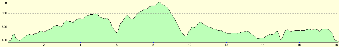
| Ashbourne bus station | Tissington | 4.3 | 591 | 220 |
| Tissington | Shirley | 9.7 | 879 | 1201 |
| Shirley | Ashbourne bus station | 4.6 | 384 | 433 |
This makes a total distance of 18.6 miles, with 1854 feet of ascent and 1854 feet of descent.
For more information on profiles, ascents and descents, see this page
Disclaimer
Please note that I take no responsibility for anything that may happen when following these directions. If you intend to follow this route, then please use the relevant maps and check the route out before you go out. As always when walking, use common sense and you should be fine.
If you find any information on any of these routes that is inaccurate, or you wish to add anything, then please email me.
All images on this site are © of the author. Any reproduction, retransmissions, or republication of all or part of any document found on this site is expressly prohibited, unless the author has explicitly granted its prior written consent to so reproduce, retransmit, or republish the material. All other rights reserved.
Although this site includes links providing convenient direct access to other Internet sites, I do not endorse, approve, certify or make warranties or representations as to the accuracy of the information on these sites.
And finally, enjoy your walking!
Nearby walks
| # | Title | Walk length (miles) |
|---|---|---|
| 14 | Friden, Long Dale and Gratton Dale | 7.8 |
| 16 | Darley Dale - Winster - Matlock | 7.0 |
| 22 | The Limestone Way from Matlock to Pomeroy | 16.9 |
|
|

|