Walk #586: A circular walk from Crowden to Bleaklow
 |
 |
|
General Data
| Date Walked | 17/01/2004 |
| County | Derbyshire |
| Start Location | Crowden car park |
| End Location | Crowden car park |
| Start time | 08.00 |
| End time | 14.14 |
| Distance | 16.3 miles |
| Description | This was a lovely walk over a snowy and picturesque Bleaklow. |
| Pack | Today I carried my 30-litre Karrimor HotRock rucksack, which was filled with my waterproof leggings, water bottle, trainers and a couple of spare shirts, together with the usual assortment of odds and ends. |
| Condition | I am slightly fatigued after this walk, and the ends of my toes on my left foot were slightly sore. Aside from this and a splitting headache I felt fine after this walk. |
| Weather | The weather today was slightly disappointing - there was no sign of any rain, and there was not much wind, but there was a thick cloud layer just below the top of the hill, which meant that I was walking through cloud for much of the day. It was quite cold on top of the hill, but it was well above freezing in the valley. |
| OS map | Outdoor Leisure number 1 (The Peak District - Dark Peak Area) |
 |
 |
|
 |
 |
|
Map of the walk
Maps courtesy of Google Maps. Route for indicative purposes only, and may have been plotted after the walk. Please let me have comments on what you think of this new format. For a detailed table of timings for this walk, please see the table file.
Notes
After seeing a friend near Rotherham yesterday afternoon I found myself in a very good position to do some walking in the High Peak, so I decided that, instead of driving home, I would drive to Crowden and camp there. After a rather nightmarish drive over the A628 road (the M62 was shut due to a crash, so all the Sheffield to Manchester traffic was using the Woodhead road instead), I pulled up in the petit village that is Crowden. Unfortunately the campsite was shut (although thankfully the toilets were open), and so I resigned myself to a night sleeping in my car. For this I used my new sleeping bag and it performed very well - despite it being cold outside I was roasty-toasty warm in the bag, and indeed I had to unzip it from the bottom to allow my feet to cool down.
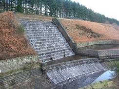
The night was quite clear, but when I woke this morning there was a layer of thin cloud overhead that was quite depressing - it would mean that the top of Bleaklow would very probably be in cloud. Despite this I was keen to set off, so after chatting to a few more walkers who parked up I set off, following the Pennine Way towards Torside Dam. The last stretch of this involved a nice walk through woodland, and there were some pretty views over the reservoir towards Torside Clough, which I would soon be climbing up. The dam itself, whilst not being as impressive as those in the nearby Derwent valley, is still impressive, and I enjoyed looking down at the various stone-built slipways, with water pouring down them.
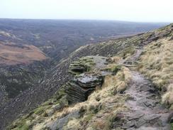
The next part of the walk took me steeply up above Reaps Farm to Clough Edge, on the western side of Torside Clough. I found this part of the walk to be quite steep, and it was a sign of how out of condition I am that I soon found myself fighting for breath - a few months ago I could have powered up the slope. A little higher and I passed the ice line, and the occasional short stretches of mill flagstones - placed to prevent erosion of the moorland - were so slippy with ice that I had to divert off them to the frozen moorland beside them. When I reached Wildboar Grain I decided no to continue along the Pennine Way to the top of Bleaklow Head, and instead I followed a path marked on the map that continue south before turning to head east to the top.
The path was initially easy to follow, but once it curved to the east it degenerated and I found myself using my compass to head in the right direction. The landscape was lovely, there were large patches of snow scatted about, contrasting well with the dark black surface of the peat and the grey of the cloud layer that I was in. After a few minutes I saw something white move in front of me and I soon realised that I was watching a Mountain Hare - the first time that I have seen one of these. I watched transfixed as it stood up on its hind legs and watched me, before running away from me. Over the next few minutes I saw three or four other Mountain Hares, and I could see many tracks in the snow beneath my feet. I could really only see them when they moved, as their white coats contrasted well against the snow and the grey cloud. I tried to take a photograph of one of them, but unfortunately due to the distance and the cloud all I can see in the resultant photo is a grey blob amidst the snow!
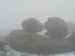
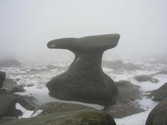
Although watching the hares was a magnificent experience, I really wanted to press on and so I continued on eastwards to the Wain Stones, which mark the top of Bleaklow Head. Two of these stones are known as the 'Kissing Stones', and as I approached it was easy to see why - the profile of the stones when viewed from a certain angle looked as though they were kissing. It was hard to find the exact top in the cloud, so I called the Wain Stones the highest point of the moor and then decided what to do next. I had several options; I could follow the Pennine Way down to the Snake Pass and then come back the same way, or I could walk across the moorland eastwards before heading down another clough to the Longendale Valley. In the end I decided to do the latter, as I hate having to walk back the same way, and much prefer circular or one-way walks.
The top of Bleaklow is nowhere near as bad to walk across as Kinder Scout, and I enjoyed tramping across the moorland, which looked very desolate with the occasional deep drifts of snow piled up against the side of groughs. The groughs on Bleaklow seem to be much fewer and less steep-sided than those on Kinder Scout, and this means that it is easier to navigate and walk across the surface. To aid navigation across the moorland there are a series of stakes, and whilst I could not see from one of these to another due to the cloud, coming across them at least confirmed that I was on course and not going off in the wrong direction. I really enjoyed this stretch of moorland, and although it may have been better if I had not been in cloud, the atmosphere on the moorland was quite magical.
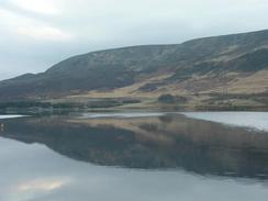
Once the path turned to head northwards I decided to parallel it a few hundred yards to the west, aiming to meet up with the path that leads down the eastern side of Far Black Clough. I found this stretch of the walk to be easy, and once I had found the path I could head on down it with ease, soon leaving the snowline with sadness - at the same time I left the cloud layer, and was greeted with a nice view over the Longendale Valley. The Woodhead Road was clearly visible, and it was not long before the noise of the cars on it became audible, a nasty stain on an otherwise peaceful valley. The path soon became a rough track that was exceedingly easy to follow as it descended, the only problem being a ford at the bottom of Far Black Clough that I had to cross - the only casualty of this being my right foot, which got damp due to cracks in my old, worn boots.
The track emerged at a car park beside the western portals of the Woodhead Tunnels. These are the third longest tunnels in Britain, and used to carry the first railway line between Manchester and Sheffield under the High Peak. The first tunnel was dug between 1829 and 1845, at a massive cost in life, and just two years later work was started on the second tunnel alongside it due to increased traffic. In 1954 a new, larger tunnel was built to replace the existing tunnel, to carry the newly electrified railway line. Unfortunately passenger services along the line stopped in January 1970, and freight services in July 1981, after which (much to the scandal of many in the railway industry) the line was shut for good. All that remains is the Trans-Pennine Trail, which follows the course of the line from Hadfield, and the three tunnels. Curiously enough one of the original tunnels is still in use, used to carry high voltage power cables under the High Peak. This saves spoiling the landscape with pylons, and they even use the water that runs down the tunnel to cool down the cables!
The Trans-Pennine Trail was an exceedingly easy walk along the old railway line, passing two of the five Longendale Valley reservoirs - initially Woodhead Reservoir, which was swiftly followed by Torside Reservoir. At the dam of Woodhead Reservoir I could cut across to the car park at Crowden, but I decided to continue on along the trail to Torside Reservoir dam to extend the walk slightly. By this time my toes were aching slightly (another sign that I have not been doing much walking recently), and I was glad when the dam came into view and I could cross over to the northern bank. Once I reached the A628 road, instead of following the Pennine Way for the last mile and a half back to Crowden, I decided to follow a concessionary footpath that sticks far lower to the side of the reservoir - a nice walk, and very different to the Pennine Way route. Eventually I reached the car park at Crowden, quite tired but very exhilarated by one of the best day's walking that I have had since the end of my coastal walk. I cannot wait to walk in this area again sometime soon, particularly if there is snow on the tops.
Directions
This walk starts off at the car park in Crowden, which is between the A628(T) Woodhead Road and the Crowden campsite. Leave the car park along the path that leads towards the toilet block, and then head north along a track for a hundred yards until a junction of tracks is met beside a farm. Here turn left and walk westwards along a track, passing the farm on the right, and continue on as the track passes a bridge over Crowden Brook and starts to climb uphill in a southwesterly direction. At the top of the hill a junction with the Pennine Way is met; this will be followed nearly to the top of Bleaklow Hill. Continue straight on along the track as it heads downhill to meet the A628(T) Woodhead Road, and then cross the road and then heads down some steps to enter an area of coniferous woodland. The path through the woodland is exceedingly distinct as it skirts near to the edge of Torside Reservoir. The path eventually leaves the woodland and then descends down some steps to reach Torside Reservoir dam.
Follow the track that runs along the top of the dam southwards, and once at the southern end follow the track as it heads uphill to the left. After a short distance the track meets a junction with the Trans-Pennine Trail; here cross the trail and the adjacent road and start heading up the driveway that leads to Reaps Farm. Just before the farm is reached turn right along an indistinct path that heads uphill; after a short distance it turns to the left and joins an indistinct track for a hundred yards. The footpath then leaves the track and turns to the right to head steeply uphill onto Clough Edge, with Torside Clough below to the left. As height is gained the path becomes more distinct and easier to follow, and as the gradient slackens the path turns to head in a more southeasterly and then easterly direction along Clough Edge. Continue on along the Pennine Way as it slowly climbs, with Torside Clough slowly getting shallower to the left.
When the junction with Wildboar Grain is met near grid reference SK081964 the Pennine Way turns to the left to follow Wildboar Grain towards Bleaklow Head; instead of doing this I continued straight on along another path that slowly curves to head westwards across the moorland to Bleaklow Head. The path became increasingly indistinct as it progressed, but it made a pleasant diversion from the motorway-like Pennine Way path. Bleaklow Head is quite a featureless place, so it is best to navigate towards the Wain Stones, a very distinctive set of rocks (see photographs). Once at the Wain Stones follow a footpath that heads eastwards across the top of Bleaklow; the route is marked by a series of stakes, but in misty conditions these can be very hard to see. Fortunately the going on the top id not too hard, and after about half a kilometre the path curves to head northeastwards to the top of Bleaklow Hill. From there it curves to the right to head eastwards for another kilometre, still following a line of stakes.
The path passes the Bleaklow Stones and then turns to the left slightly to head northeastwards for another kilometre. The path then turns to head northwards, again following stakes; however as I wanted to meet up with the path on Far Black Clough I walked a hundred yards to the west of the path as it headed northwards, and was pleased to meet the start of the path exactly end-on! The path is initially fairly indistinct, but as it descends along the eastern bank of the Clough it becomes more distinct, and shortly after it follows the Clough to the northwest it becomes a track. Follow the track downhill; to the left the stream becomes larger as it descends. A little diversion around a rock outcrop leads to a ford across the stream; this was under ankle-deep when I crossed, so if you have waterproof boots it should be fine; after heavy rain I can imagine the crossing being more difficulty, however. Once on the other side of the ford follow the track as it skirts the southern side of the stream as it heads northwestwards; when a bridge is reached cross it to gain access to a car park on the northern bank.
Once across the bridge turn left and walk downhill for a few yards to gain access to the Trans-Pennine Trail by the portals of the three Woodhead tunnels. Follow the Trans-Pennine Trail as it heads westwards along the southern bank of Woodhead and Torside Reservoirs for four miles. Once the junction with the Pennine Way is reached at the crossing of the B6105 road turn right and descend down a track, following the Pennine Way to Torside dam. Cross the dam and once on the northern bank climb up some steps and turn right to follow the Pennine Way through an area of woodland. Once the path meets the steps that lead up to the A628(T) you have a choice; you can either follow the Pennine Way back to Crowden (following the start of this walk in reverse), or you can turn right to follow a concessionary footpath that skirts the northern bank of Torside Reservoir.
This path is quite distinct and easy to follow; once it crosses the outfall of Crowden Brook follow the path up towards the A628(T) road in Crowden; when the path turns away to the right continue straight on for a few yards to the A628(T) road. Cross the stile and then turn right along the pavement of the A628(T) for fifty yards, before turning left up the road that leads into Crowden. A few yards up this road turn left down a surfaced track that leads down into Crowden car park, where this walk ends.
Distances
| From | To | Distance (m) | Ascent (ft) | Descent (ft) |
|---|---|---|---|---|
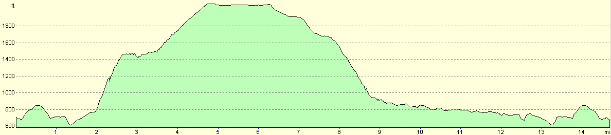
| Crowden car park | Bleaklow Head | 6.3 | 2140 | 771 |
| Bleaklow Head | Woodhead Tunnel portals | 4.5 | 164 | 1336 |
| Woodhead Tunnel portals | Crowden car park | 5.5 | 571 | 768 |
This makes a total distance of 16.3 miles, with 2875 feet of ascent and 2875 feet of descent.
For more information on profiles, ascents and descents, see this page
Disclaimer
Please note that I take no responsibility for anything that may happen when following these directions. If you intend to follow this route, then please use the relevant maps and check the route out before you go out. As always when walking, use common sense and you should be fine.
If you find any information on any of these routes that is inaccurate, or you wish to add anything, then please email me.
All images on this site are © of the author. Any reproduction, retransmissions, or republication of all or part of any document found on this site is expressly prohibited, unless the author has explicitly granted its prior written consent to so reproduce, retransmit, or republish the material. All other rights reserved.
Although this site includes links providing convenient direct access to other Internet sites, I do not endorse, approve, certify or make warranties or representations as to the accuracy of the information on these sites.
And finally, enjoy your walking!
Nearby walks
| # | Title | Walk length (miles) |
|---|---|---|
| 13 | Edale and Kinder Scout | 11.0 |
| 30 | Edale to Crowden | 16.5 |
| 31 | Crowden to Standedge | 11.7 |
|
|

|