Walk #585: Kinder Scout from the Snake Pass
 |
 |
|
General Data
| Date Walked | 03/01/2004 |
| County | Derbyshire |
| Start Location | Birchen Clough car park |
| End Location | Birchen Clough car park |
| Start time | 08.58 |
| End time | 14.30 |
| Distance | 11.0 miles |
| Description | This was a lovely walk in some imperfect conditions, across the centre of Kinder Scout. |
| Pack | Today I carried my 30-litre Karrimor HotRock rucksack, which was filled with my waterproof leggings, water bottle, trainers and a couple of spare shirts, together with the usual assortment of odds and ends. |
| Condition | I feel absolutely fine after this walk, and I could have easily walked further if I had needed to. |
| Weather | There was low cloud over the top of Kinder and at the top it was below freezing, but despite this it was not too bad as there was little sign of any precipitation, a little bit of sleet being the worst of it. The wind was nowhere near as bad as it was last time I was on Kinder, and if it had been strong it would have been quite unpleasant at the top. |
| OS map | Outdoor Leisure number 1 (The Peak District - Dark Peak Area) |
 |
 |
|
 |
Map of the walk
Maps courtesy of Google Maps. Route for indicative purposes only, and may have been plotted after the walk. Please let me have comments on what you think of this new format. For a detailed table of timings for this walk, please see the table file.
Notes
I had not done a walk for a few days, and as I had an old university friend, Mike, staying we decided to go out onto Kinder for the day. We planned the walk last night, and we decided that instead of going to Edale (the nearest part of Kinder to where I live in Uttoxeter) we would walk from the Snake Pass, an extra thirty to forty minutes away. When I woke up this morning I went downstairs to make some much-needed coffee, and I was slightly dismayed to see it snowing outside. If it is snowing here in Doveridge then the roads are usually quite bad further north, and so I was hesitant about whether we could get through to Buxton, yet alone the Snake Pass. After talking to Mike we decided to set out, and although the road to the south of Buxton and the highest part of the Snake Pass were quite icy. We were going to park at the Snake Inn, but instead we chose to park in a large lay-by by the bridge over Birchen Clough.
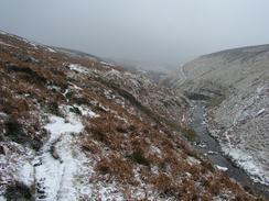
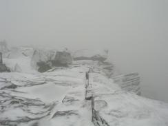
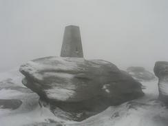
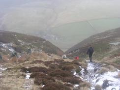
We soon pulled on our waterproof gear and set off along a track that led southwards through the woodland to Ashop Clough. The cloud was very low on the flanks of Kinder Scout, and so we were not hopeful of having very good weather. The path slowly rose up as it followed the clough westwards, and we soon found ourselves going above the freezing line and into snow. The going was quite easy despite this, and we soon passed another group of walkers and reached the Pennine Way by Ashop Head. By now we were in the cloud, and although visibility was not really bad it was not good either. Fortunately the Pennine Way is not hard to follow as it climbs southeastwards up onto the Kinder plateau, the only steep climb of the day, and we were surprised to find a frozen boot resting on a cairn of stones. The walk to Kinder Downfall was very easy, and we started to see more people along this western edge of the hill. At the Downfall we stopped for ten minutes to have a bite to eat and a warm drink, although it was a bit cold for hanging around and so we walked on southwards to the trig point at Kinder Low, which was covered in wind-blown ice crystals.
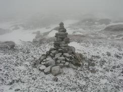
One of the aims of the walk was to get to the county top of Derbyshire, at 636 metres about three-quarters of a kilometre away from the trig point at Kinder Low. We headed across the moorland towards the top, the occasional frightened grouse startling us with their calls as we walked past. When we got to the general area of the top it was hard to find where the exact top was (the whole area being riddled with deep groughs), and so we settled on making a wooden post surrounded by a cairn the top. It was quite a featureless and windswept place aside from the post, and it was not really a place to hang around, so we soon moved on after taking a couple of photographs. On the 1:25,000 map there is a path marked on the map, but there was no sign of this on the ground (as I expected) and so progress became harder than it had been around the well-trodden western edge of the plateau.
As we headed across the top of the black mess I was amused to look down at the case of my GPS to see that the sleet had frozen to it, forming little particles of ice that obscured the display. The same thing had happened to my map case, and I was quite glad that I had put my map into the case before I had set off. It was the first time in years that I had voyaged across the centre of Kinder, and it reminded me exactly how hard compass navigation is in this area. The moor is fairly featureless, and as you go down into one of the steep-sided groughs it is hard to get out on exactly the same bearing, and it is always tempting to skirt around groughs and thus go off course rather than go over and under them. To get to Crowden Head in the centre of Kinder I navigated using my GPS, but as it is a moving compass it is quite hard to get an accurate bearing when you are climbing out of the groughs, and so I soon realised that we were heading too far north. A quick leg to the east put us back on course to Crowden Head, and from there Mike took over with the compass whilst I remained using the GPS.
The snow was not the deepest that I have seen it on Kinder since 1999, and a good point about the frozen ground was that we did not sink into the peat too much (a frequent problem on Kinder, particularly after rain). At one point I feel up to my waist in a snowdrift, but whilst progress was relatively slow it was quite a fun walk, and very different from the walking that I have been doing recently. Kinder in these conditions has to be experienced; whilst it is relatively hard going I certainly gained a lot from the walk. The only downside was that climbing out of the groughs and snow was putting strain on my bad ankle, and whilst this was not too bad it made me wince once or twice when I could not get a firm footing under the surface of the snow.
It was with a slight relief that we reached the northern edge of Kinder near Upper Seal Clough, and we could join a reasonable track along the edge of the plateau. This allowed us to make much faster progress, and although there was snow in places the path was mainly clear and we could storm along. We were planning to walk down Gate Side Clough and after we walked a hundred yards past it (my fault!) we headed down the steep slope and finally walked down the path. The first part of this descent was quite steep and covered in snow, so we had to go quite carefully, and I was glad that Mike was in front of me as I could use his footprints instead of kicking my own steps. Fairly shortly after we started the descent we emerged from the cloud layer and for the first time in the day we got a reasonable view, with the Snake Pass visible in the distance. After posing for photographs in the middle of Fair Brook, which we had to cross, we made our way to the Snake Pass road just before the Snake Pass Inn. Another kilometre further north we reached the car park, and we then drove back to the Inn for a well-deserved drink and meal. All in all it was an enjoyable walk, although it was a shame about the low cloud.
Directions
This walk starts off at the Birchen Clough car park, a kilometre to the north of the Snake Inn on the Snake Pass. Leave the car park and cross the road to a stile that leads down a path for a short distance through the woodland to a little footbridge over a stream. Continue on for a few yards and then turn slightly to the left, cross a track and follow a path southwards for a little over half a kilometre through the woodland. The path leaves the woodland by a footbridge over a little stream; here turn right and follow a path westwards between the edge of the forest and the River Ashop. When the woodland on the right ends climb slightly uphill to the right to join a more distinct path, and follow this as it slowly climbs westwards up Ashop Clough along the Snake Path. The Snake Path runs along the northern side of Ashop Clough, passing an old ruined stone building before eventually turning to the left to head southwards for a couple of hundred yards to reach a post marking the junction with the Pennine Way at Ashop Head.
At the post turn left and start climbing steeply southeastwards along the Pennine Way onto the edge of Kinder. Once on the edge follow the distinct path as it heads southeastwards for a couple of kilometres until it reaches Kinder Downfall, where it turns to head southwards. From Kinder Downfall head southwards for another couple of kilometres, passing Red Brook before skirting to the left of an area of slightly higher ground. Here turn to the left slightly and make your way across an area of Peak Bog to the trig point at Kinder Low, which stands prominently on an exposed stone outcrop. From the trig point you have to rely on compass navigation to head in a rough northeasterly direction across the peat bogs, aiming for the highest point in Derbyshire at 636 metres in height. This point is marked by a wooden post (I believe) - and is thus easier to find that it would be if it were not present, as it is hard to find the exact top as the land surface is so flat.
Once at the top head in a slightly more easterly direction for a kilometre to Crowden Head, and then head northeastwards for another kilometre to reach the northern edge of the Kinder plateau near Upper Seal Clough. Once at the edge follow the obvious path eastwards along the edge for a little under a mile until the top of Gate Side Clough is reached. Here a path heads steeply downhill to the north, before flattening out and running beside a derelict stone wall. As the Clough becomes more obvious the path crosses the stream and joins the western side of the stream; it then curves around a bluff and descends to the northwest, descending down to meet a ford over Fair Brook. Cross the brook using the ford and then follow the path northwards for about a hundred yards until a footbridge over the River Ashop is reached on the right; cross this footbridge and on the other side head northwards along a distinct path through the woodland to the Snake Pass road. One on the road turn left and follow it northwestwards for a few hundred yards to the Snake Inn, and then continue on for a kilometre, initially northwestwards and then northwards. There is a footpath on the left-hand side of the road, which means that walking along it is relatively safe. At a left-hand bend the road reaches the car park at Birchen Clough, where this walk ends.
Distances
| From | To | Distance (m) | Ascent (ft) | Descent (ft) |
|---|---|---|---|---|
| Birchen Clough car park | Kinder Downfall | 5.1 | 1316 | 535 |
| Kinder Downfall | Derbyshire county top | 1.8 | 246 | 118 |
| Derbyshire county top | Birchen Clough car park | 4.1 | 400 | 1309 |
This makes a total distance of 11.0 miles, with 1962 feet of ascent and 1962 feet of descent.
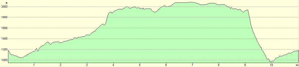
For more information on profiles, ascents and descents, see this page
Disclaimer
Please note that I take no responsibility for anything that may happen when following these directions. If you intend to follow this route, then please use the relevant maps and check the route out before you go out. As always when walking, use common sense and you should be fine.
If you find any information on any of these routes that is inaccurate, or you wish to add anything, then please email me.
All images on this site are © of the author. Any reproduction, retransmissions, or republication of all or part of any document found on this site is expressly prohibited, unless the author has explicitly granted its prior written consent to so reproduce, retransmit, or republish the material. All other rights reserved.
Although this site includes links providing convenient direct access to other Internet sites, I do not endorse, approve, certify or make warranties or representations as to the accuracy of the information on these sites.
And finally, enjoy your walking!
Nearby walks
| # | Title | Walk length (miles) |
|---|---|---|
| 13 | Edale and Kinder Scout | 11.0 |
| 19 | Castleton circular via Lose Hill and Mam Tor | 7.7 |
| 23 | The Limestone Way from Pomeroy to Castleton | 14.0 |
|
|

|