Walk #573: North Pickenham to Dovehill Wood
 |
 |
|
General Data
| Date Walked | 20/10/2003 |
| County | Norfolk |
| Start Location | North Pickenham |
| End Location | Dovehill Wood |
| Start time | 08.50 |
| End time | 17.04 |
| Distance | 20.8 miles |
| Description | This was a long and fairly boring plod following the Peddars Way, during which there was not much of note to see. |
| Pack | Today I carried my 70-litre Craghoppers rucksack holding full camping gear and my new Jack Wolfskin Gossamer tent. |
| Condition | I feel absolutely fine after this walk, and I could easily have walked further with a little rest. My left shoulder aches slightly, but this was not as bad as yesterday and did not bother me overly. |
| Weather | Today was a very changeable day, with lots of sunshine but also several heavy showers that were highly annoying. One of the showers was of hail, although this was not enough to force me to put my coat on as I guessed that it would not last long and my fleece coped admirably with it. |
| OS map | Landranger number 144 (Thetford & Diss, Breckland & Wymondham) and Landranger number 132 (North West Norfolk, King's Lynn & Fakenham) |
 |
 |
|
 |
 |
|
Map of the walk
Maps courtesy of Google Maps. Route for indicative purposes only, and may have been plotted after the walk. Please let me have comments on what you think of this new format. For a detailed table of timings for this walk, please see the table file.
Notes
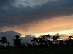
One of the things that I have always loved about wild camping is getting up in the morning to see a lovely sunrise, and I was fortunate enough to see one this morning. I had been awake for some time listening to the radio before the sun eventually rose, and when it did I got up to see a beautiful red sky to the east. It was a chilly morning and I did not feel like cooking any breakfast, so I went back into the tent to get warm.
The tent performed reasonably well last night - it kept me dry through the heavy showers that we had overnight, and I got a good night sleep. It was very draughty, however, with the wind getting under the flysheet and coming straight through the mesh inner. This proved to be no problem whilst I was in my sleeping bag, but was highly annoying when I was not. All in all I conclude that the Gossamer is not a cold weather tent and would best be used in relatively good weather. It is a fairly comfortable tent, although my North Face Westwind is far roomier and comfortable. The Westwind is about twice the weight, however, so it is a case of comfort versus weight. I am fairly happy about the Gossamer (especially considering the price that I paid for it), although it is limited in the seasons in which I could use it.
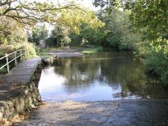
I set off shortly before nine down Procession lane, a nice lane that forms part of the Peddars Way. I soon reached the A47 crossing, and I easily managed to avoid nipping into the McDonalds adjacent to the path for an ill-named big breakfast. The pat continued on northwards, mainly along surfaced roads, but there were some gravel and unmade stretches. Eventually I reached the ford that carries a road across the River Nar, although I chickened out from fording the river and crossed by the little footbridge before climbing up into Castle Acre. I had set off at nine so that I would be able to reach Castle Acre by eleven, when I hoped that one of the pubs in the village would be open. I arrived ten minutes early, but I soon discovered that they both did not open until midday. Not wanting to hang around for well over an hour, I walked he short distance to the ruins of the priory and used the toilets there. The ruins of the priory and the castle are run by English Heritage and cost four pounds per person to enter, and this put me off going in for the short time that I was in the village. I had not had a coffee this morning, so I nipped into a lovely little cafe to have one, which I drunk with a piece of homemade fruitcake. There was a couple in the cafe that I chatted to for some time about the coastal trip and the local area, and the owner of the cafe kindly filled up my water bottle for me.
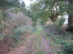
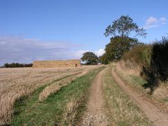
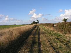
The trail north of Castle Acre is exceedingly straight and proved ridiculously easy to follow, although like all Roman Roads it climbs up and down the hills rather than contouring around them. This made for what I unfortunately found to be a very boring afternoon walk, especially as the path was in most places quite wide and followed roads, tracks or green lanes for much of the way. There was not much of interest beside the route, and so I put myself yet again onto autopilot and just walked. This was a shame as there is potentially some interesting things to see in the area, but the path misses these just as it misses all the villages on this long, straight section. I found myself slowly becoming disheartened, and consequently I found it increasingly hard to try and maintain a good pace. Eventually at about three I admitted defeat and sat down by the side of the track. I took my rucksack off and just relaxed for twenty minutes, allowing my body to have a slight rest. Fortunately this coincided with a sunny period of weather, and so I did not have to sit down in the rain. The only downside to doing this was that I found that my legs were exceedingly stiff for the first five minutes once I restarted; this often happens if I sit down on the ground for a rest.
I had decided last night that if the weather was reasonable I would walk as far as Sedgeford today, which I guessed would be about twenty miles. As I approached the village I started to look for somewhere that I could camp for the night, and on the map I could see that Dovehill Wood seemed to look a possibility. When I eventually reached the wood, which is perched on a hill to the south of the village, I could see a clearing in the trees that was a reasonable distance from the path, and so I decided to camp there. The clearing had ivy on the floor, which promised to be a better proposition than the brambles that I had to pitch it on yesterday!
Sedgeford has a pub, and once I had set he tent up I was very tempted to walk the mile into the village to visit it. In the end apathy and tiredness won out, and I ended up wrapping myself up in the sleeping bag as the wind howled through the trees and around the tent. A pint would have been nice, but being warm was far more enticing! Before I went to sleep I did a little test - my mobile phone has a thermometer on it, and outside my sleeping bag but inside the tent it was about three degrees Celsius, yet inside my sleeping bag it was over thirty! I am quite pleased by this, especially as the thin summer sleeping bag that I am using should find it hard to cope at these sort of temperatures.
I only have a short distance to walk tomorrow before I reach Hunstanton, although I may extend the walk by walking south of the town for a short distance to Heacham. I do not have the map for this, however, so I would have to rely on my memory of the walk, and I am also keen to get back to Cambridge to see Sam.
Directions
|
This walk follows the Peddars Way stretch of the Peddars Way and Norfolk Coast Path National Trail for its entirety. This path is very well waymarked and is navigationally easy, and directions and route maps are included in the excellent National Trail Guide 15, Peddars Way and Norfolk Coast Path by Bruce Robinson and published by Aurum Press, ISBN 1-85410-852-2. Because of this excellent guide I (as normal for National Trails) am not including directions for this walk, as the guidebook is unbeatable. Please click on the link to the right to access the Amazon page for the guidebook. |

|
Distances
| From | To | Distance (m) | Ascent (ft) | Descent (ft) |
|---|---|---|---|---|
| Campsite near North Pickenham | Castle Acre | 6.3 | 272 | 292 |
| Castle Acre | Harpley Dams | 7.2 | 387 | 394 |
| Harpley Dams | Dovehill Wood | 7.3 | 397 | 335 |
This makes a total distance of 20.8 miles, with 1056 feet of ascent and 1021 feet of descent.
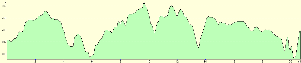
For more information on profiles, ascents and descents, see this page
Accommodation
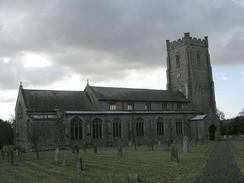
I spent the night in my tent secreted away in Dovehill Wood, which is on a hill to the southeast of the village of Sedgeford and just to the north of Fring Cross. This was a reasonable place to spend the night, and although it was a little exposed to the wind the trees protected me somewhat from the elements.
Disclaimer
Please note that I take no responsibility for anything that may happen when following these directions. If you intend to follow this route, then please use the relevant maps and check the route out before you go out. As always when walking, use common sense and you should be fine.
If you find any information on any of these routes that is inaccurate, or you wish to add anything, then please email me.
All images on this site are © of the author. Any reproduction, retransmissions, or republication of all or part of any document found on this site is expressly prohibited, unless the author has explicitly granted its prior written consent to so reproduce, retransmit, or republish the material. All other rights reserved.
Although this site includes links providing convenient direct access to other Internet sites, I do not endorse, approve, certify or make warranties or representations as to the accuracy of the information on these sites.
And finally, enjoy your walking!
This walk was mentioned in the following routes:
| Peddars Way and Norfolk Coast Path |
Nearby walks
| # | Title | Walk length (miles) |
|---|---|---|
| 9 | Old Hunstanton and Holme | 4.0 |
| 133 | Hunstanton to Burnham Deepdale | 10.3 |
| 156 | Kings Lynn to Snettisham | 14.6 |
|
|

|