Walk #545: Nairn to Findhorn
 |
 |
|
General Data
| Date Walked | 02/09/2003 |
| County | Highlands, Grampian |
| Start Location | Nairn |
| End Location | Findhorn |
| Start time | 10.25 |
| End time | 18.41 |
| Distance | 24.1 miles |
| Description | This was a lovely and varied walk, with some nice views available in places. |
| Pack | Today I carried my 30-litre Karrimor HotRock rucksack, which was filled with my packed lunch, waterproof leggings, water bottle and a couple of spare shirts, together with the usual assortment of odds and ends. |
| Condition | Aside from a possibly significant problem with my left foot (see below) I did not have many other problems. My right foot gave a few twinges, but nothing serious. |
| Weather | The weather today was very much like yesterdays, with lots of cloud and only infrequent sunny periods. It was dry all day and it was not a cold day, although the wind got a bit chilly at times. |
| OS map | Landranger number 27 (Nairn & Forres, River Findhorn) |
 |
 |
|
Map of the walk
Maps courtesy of Google Maps. Route for indicative purposes only, and may have been plotted after the walk. Please let me have comments on what you think of this new format. For a detailed table of timings for this walk, please see the table file.
Notes
Today was a bit of a red-letter day, as after two months I left the Highlands and entered Grampian. When I look back over all the time that I have been in the Highlands - I entered it near Portnocroish on July 1st - I find it amazing the distance I have walked in just one county. Walking around the Highlands has been a great experience, and although I have had highs and lows it has been by far the best part of the walk so far.
I woke up a couple of times last night due to pain in my left foot. At one point this was reasonably severe, so I went downstairs and sprayed the afflicted spot with Deep Heat. This seemed to ease the pain, and I slept through the rest of the night reasonably well. In the morning it was quite sore, and so I decided to wear my boots, which I believed may give my foot more support.
We had to drive from the campsite in Inverness to Nairn for me to start my walk, and we arrived in the lovely town at about ten. I was still quite tired however, and so we had a cup of coffee whilst we sat in Mervan and admired the view, which included an ornate bandstand that commemorated a local man who emigrated to Australia in the 1800's. When I eventually set off my left foot felt fine, and I walked past the harbour and out onto the beach to the east of the town. After a mile, however, I suddenly felt something snap in the lower section of my left foot, a feeling that was accompanied by intense pain. The next couple of steps were, frankly, agony, so I sat down on the ground and took my left boot and sock off. The foot looked fine, but it was extremely tender on the top and bottom of my foot at the spot where the pain was.
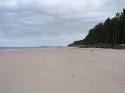
I rubbed both sides of my foot for a few minutes before getting up and gingerly putting weight on it. It ached a lot, but there was not the intense pain of a few minutes before. I walked for a few yards without boot or sock, and then walked back again. I sat down once again to put the boot and sock back on, and nervously set off once more. The foot was hurting a great deal, but the pain was not as intense as it had been, so I decided to continue on. I had been planning to walk on tracks through Culbin Forest, but as I walked along the beach in front of the dunes I found a path that headed on the seaward side of the woodland.
The walk along the foreshore was easy enough, although my left foot was still hurting a great deal, and it was much preferable to walking though woodland for mile upon mile. Unfortunately I could not see much of the sea as the tide as a long way out and a line of dunes called The Bar blocked views of the sea. It was an enjoyable stroll, and I made good progress northeastwards, soon crossing over the border into Grampian. Navigation was easy, as it was just a case of keeping the trees to my right. Eventually, however, I reached an area where a set of sand dunes (part of a west-facing sand bar) joined the shore, and I had to follow a track through the forest before going over a bank and joining a sandy beach.
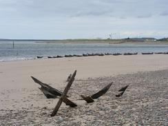
Near the mouth of the River Findhorn I came across fifty or sixty seals basking on the beach. As I approached most of them went into the sea, leaving one solitary one eyeing me suspiciously. I stood motionless for a couple of minutes, and many of them came out of the water, allowing me to take some photographs before I set off one again. I rounded the mouth of the River and entered Findhorn Bay, still keeping the forest to my right, and near a little boathouse I turned to follow tracks through the woodland to Wellside Farm. On this track I met a quite rude man who stopped in a car and asked me the way to the river. I told him the way as far as I could see, but it seemed as though he wanted precise directions - these were hard to give as the bay is quite large and he would not tell me which part he wanted to get to!
I met Sam for a very late lunch in a housing estate near Moy House, and I used the opportunity to look at my left foot. This had been sore for the last couple of hours without much pain, and once I took my boot off I was glad to see that it was not swollen. It was very tender to the touch, however, and was far from right. I had a lot of road walking to do for the rest of the afternoon, and so I decided to change into my trainers for the remainder of the day. I managed to use a little bridge over the River Findhorn at Broom of Moy, which saved me having to walk down to the main road bridge to cross the river. More road walking allowed me to eventually reach the outskirts of Kinloss, and just before I reached the attractive church I passed the nice and tiny Abbey Inn, in a row of low, squat cottages.
The B9011 passed RAF Kinloss, and I could see many planes lined up on the apron as well as the large hangars near the runway. Near to this was the Findhorn Foundation, an alternative lifestyle community, which I imagined must fit in quite well with the airfield. Sam was waiting for me in the car park in Findhorn, and I was glad when I finally reached Mervan and could clamber in. I was quite relieved that despite the problems with my left foot I could manage well over twenty miles. So what happened? When I first felt the snap and the pain I was afraid that a bone had fractured - the pain was that intense for a few minutes. If that had happened, however, I doubt I could have walked as far as I did, and I would expect my foot to be swollen, which it is not. a couple of years ago I had a muscle in my left calf let go, and that gave a similar 'snapping' sensation, which was accompanied with a severe cramp in the leg. I can only assume that a muscle let go in the lower part of my left foot, and that is what caused the problem.
Directions
This walk starts off at a car park near to the bandstand in Nairn. Walk to the seafront and then turn right to walk along the promenade towards the harbour. Use a bridge over the River Nairn to get past the harbour, and on the other side turn left down a track that leads past the eastern breakwater of the harbour to gain access to the beach.
At the beach turn right and walk eastwards along it, with sand dunes to the right. After a little over a kilometre the dunes end and an area of marshland begins; cross a stream and continue on until the south westernmost tip of Culbin Forest is reached. At the forest turn slightly left and follow a distinct path northeastwards between the edge of the forest and a marshy area of land. This path never enters the forest and always keeps it within sight.
Near grid reference NH995646 the path appeared to peter out in an area of woodland; I followed a track through the forest until it cam close to a low bank of sand dunes, and I then crossed these to gain access to a proper, sandy beach. Follow this beach eastwards for another couple of miles until the moth if the River Findhorn is reached, and then turn right to follow the edge of the forest around the mouth. The beach becomes increasingly muddy as Findhorn Bay is reached, and near grid reference NJ033636 (just north of a little hut) turn right and walk westwards through the forest.
After a few hundred yards turn right down another track that initially heads south but soon swings around to head westwards through the forest. At a crossroad of tracks turn left to head southwards for a hundred yards or so down another track towards the farm at Binsness, and then turn right down yet another track. Fairly soon this track leaves the woodland and runs along the side of Findhorn Bay. The track eventually becomes a public road at Wellside Farm, and it can be followed southwards past Kincorth House and Moy House.
Immediately after the road passes under a set of power lines turn left down another road that leads eastwards for a little under a kilometre until it ends at the Broom of Moy. When the road curves to the left continue straight on down a track that leads to a large bridge over the River Findhorn. Cross this bridge and on the other side turn left to follow a track that heads through woodland and eventually emerges at a road. Turn left to follow this road northwards and then northeastwards as it passed Seafield. It then curves to head south through Netherton and ends at a T-junction to the south of Mill of Grange.
Turn left at the junction and follow another road northeastwards for a couple of miles past Mill of Grange until it ends at the B9011 road. At the junction turn left for a few hundred yards until the B9011 road itself reaches Kinloss. In Kinloss turn left and follow the B9011 road northwestwards past the church and on for another three miles as it heads up the eastern side of Findhorn Bay and into Findhorn. When the road ends continue straight on past a couple of jetties and then turn to the right to reach a car park behind the beach, where this walk ends.
Distances
| From | To | Distance (m) | Ascent (ft) | Descent (ft) |
|---|---|---|---|---|
| Nairn | Mouth of River Findhorn | 11.3 | 217 | 256 |
| Mouth of River Findhorn | Findhorn | 12.8 | 233 | 230 |
This makes a total distance of 24.1 miles, with 450 feet of ascent and 486 feet of descent.
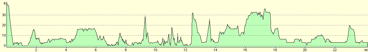
For more information on profiles, ascents and descents, see this page
Accommodation
We spent the night at the large car park near the harbour in Findhorn, which was near to some public toilets and the local pubs.
Disclaimer
Please note that I take no responsibility for anything that may happen when following these directions. If you intend to follow this route, then please use the relevant maps and check the route out before you go out. As always when walking, use common sense and you should be fine.
If you find any information on any of these routes that is inaccurate, or you wish to add anything, then please email me.
All images on this site are © of the author. Any reproduction, retransmissions, or republication of all or part of any document found on this site is expressly prohibited, unless the author has explicitly granted its prior written consent to so reproduce, retransmit, or republish the material. All other rights reserved.
Although this site includes links providing convenient direct access to other Internet sites, I do not endorse, approve, certify or make warranties or representations as to the accuracy of the information on these sites.
And finally, enjoy your walking!
This walk was mentioned in the following routes:
| My walk around the coastline of Britain |
Nearby walks
| # | Title | Walk length (miles) |
|---|---|---|
| 544 | Inverness to Nairn | 25.6 |
|
|

|