Walk #546: Findhorn to Lossiemouth
 |
 |
|
General Data
| Date Walked | 03/09/2003 |
| County | Grampian |
| Start Location | Findhorn |
| End Location | Lossiemouth |
| Start time | 07.20 |
| End time | 15.54 |
| Distance | 17.0 miles |
| Description | This was a quite enjoyable walk, with many things of interest to be seen on the way. |
| Pack | Today I carried my 30-litre Karrimor HotRock rucksack, which was filled with my packed lunch, waterproof leggings, water bottle and a couple of spare shirts, together with the usual assortment of odds and ends. |
| Condition | I did not have any trouble with either of my feet today, which is quite a relief after yesterday, when I had significant problems. I did not have any other problems either, and could have walked further if I had needed to. |
| Weather | Today was an absolutely superb day with lots of sunshine and relatively high temperatures. There was not a great deal of wind, and when it was cloudy this was high and thin. |
| OS map | Landranger number 27 (Nairn & Forres, River Findhorn) and Landranger number 28 (Elgin, Dufftown & surrounding area) |
 |
 |
|
 |
 |
|
Map of the walk
Maps courtesy of Google Maps. Route for indicative purposes only, and may have been plotted after the walk. Please let me have comments on what you think of this new format. For a detailed table of timings for this walk, please see the table file.
Notes
I woke up this morning after a much better night's sleep, and I was pleased to find that my left foot did not hurt, or even ache. This was a great relief, and I could only hope that it would remain okay for today's walk. I felt quite low for reasons I cannot explain, and I was eager to start the walk to prevent getting that early morning hanging around feeling.
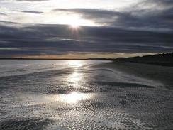
Sam had arranged for us to go and visit a Riding for the Disabled group in Covesea before lunch, and so I decided that an early morning start was very much in order. I had a cup of coffee, and set off shortly after seven. The initial part of the walk was a seven mile stroll along a beach to Burghead, and the sun was low in the sky ahead of me as I walked, making the coast off the Black Isle glint red behind me. It was a magical early morning walk, and I was pleased to see that I was not alone - a man was swimming in the sea (rather him than me, it must have been really cold at that time of the morning), another man was jogging and a girl with the hood of her parka drawn tight over her had was high up on a sand dune playing a whistle. It was a magical moment, and I enjoyed listening to her play as I stood and watched the sun.
The seven miles of beach walking just flew by as I walked past Second World War anti-tank defences and pillboxes, slowly being undermined by the sea. For a few miles my nostrils were assaulted by the smell of Kerosene as heavy jets took off from RAF Kinloss, the runway being very close by through the tree behind the base. I soon arrived in the pretty little fishing village of Buurghead, where Sam was waiting for me in a car park near to the harbour. She had some raisin toast and a coffee waiting for me. I wolfed the first load of toast down, and she kindly kept on plying me with it until I was well and truly stuffed.
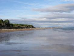
The walk from Burghead to Hopeman was very nice, and much of it was along a disused railway trackbed that made for good, fast walking. There was a path that went slightly to the seaward side of the trackbed, but I decided to stick to the more level path. In one place the trackbed was quite severely eroded, and the path just managed to stick to the top of the remaining bank. I soon reached the harbour at Hopeman, and found Mervan in the car park beside it.
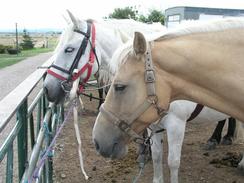
The Riding for the Disabled group that we were visiting was beside the Lossiemouth RAF base, and we had an entertaining hour with them as they took people around on the horses. This was the first group that we had visited since Dumfries (there not being many groups on the western and northern coasts of Scotland), and so it was nice to remind myself of the wonderful work that these people do.
Sam dropped me off back at the car park in Hopeman and I restarted the walk along the path that ran at the top of the low cliffs. It was quite easy going, and I enjoyed the walk and the views immensely. There were several signs as I went, and one of these that was surrounded by large slabs of stone described the dinosaur footprints on them. I studied these for some time, and was glad of the board that showed me what all the impressions were.
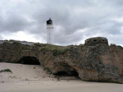
Eventually I reached the beach and proceeded on past the lighthouse at Covesea and on towards Lossiemouth. Just before I reached the western side of the town I passed directly under the flight path of the planes coming into land at the RAF airport. I stood on the beach for ten minutes watching them coming in to land, amazed at the way the Tornados seemed to be flying so slowly as they came in.
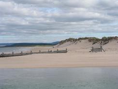
I walked around the seaward side of the town before reaching Mervan, which was parked in a car park near the bridge over to the east beach. I was tempted to walk on further as it had been a short day, but there was nowhere Sam could pick me up until I reached Kingston a fair few miles more east along the coast, and so with regret I decided to end this rather interrupted day. I do not know whether it was because it was such a start-stop day, or the short distance, but I felt very dissatisfied with today's walk, which was a shame as the visit the Riding for the Disabled group had been very enjoyable.
Directions
This walk starts off at the large car park near the mouth of the River Findhorn in the village of Findhorn. Leave the car park and head north across the sand dunes onto the beach. Turn right and walk along the beach for nearly seven miles; initially eastwards but the beach slowly curves around to head northwards past an area of woodland.
Eventually the beach meets the seawall in the village of Burghead. Climb up a ramp onto the seawall and turn left to follow it westwards towards the harbour. Walk past the harbour and at the far end climb up some steps in a stone rock face to a road, and then climb up a grassy slope to reach a white round building (now a visitor centre) at the top of the hill. Just before the building is reached take a path that heads downhill around the flank of the hill to gain access to the seawall at the northern side of the building.
At the bottom of the hill turn right and follow a track along the top of the seawall eastwards past a large factory. Immediately beyond the factory join the trackbed of an old railway line, and follow this as it heads eastwards along the coast. In one place the embankment is nearly eroded away; the path continues along the top. After a couple of miles the path ends at a bridge over a cutting; the cutting under the bridge being filled in. Climb some steps up to the right to gain access to the top of the bridge, and the turn left to cross the bridge and reach a track that runs beside the seashore. Turn right to head eastwards for a few hundred yards to Hopeman Harbour.
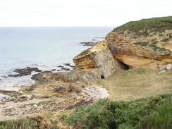
Turn left to descend down the road for a few yards and then turn to the right down another road that leads to a car park. At the far end of the car park a path leads off to the east, following the cliffs around a golf course and reaching Clasbach Cove. The path is then distinct as it joins a track above a quarry (marked as disused on the map, but in use when I passed), and continues on eastwards towards Covesea, where the cliffs lower and a beach is reached. Join the beach and follow it eastwards past the Covesea lighthouse and past the Little Skerries to reach the western outskirts of Lossiemouth.
Past the golf course there is a car park, and from here a path heads around the top of low cliffs before ending at Shore Street in Branderburgh. Follow Shore Street along past the Harbourmasters office until the end of the harbour is reached, and then turn right to head southwards past a marina. Near a bridge over a canal there is the Gregory Place car park, where this walk ends.
Distances
| From | To | Distance (m) | Ascent (ft) | Descent (ft) |
|---|---|---|---|---|
| Findhorn | Burghead | 6.8 | 121 | 89 |
| Burghead | Hopeman | 3.0 | 177 | 207 |
| Hopeman | Lossiemouth | 7.2 | 505 | 509 |
This makes a total distance of 17.0 miles, with 803 feet of ascent and 805 feet of descent.
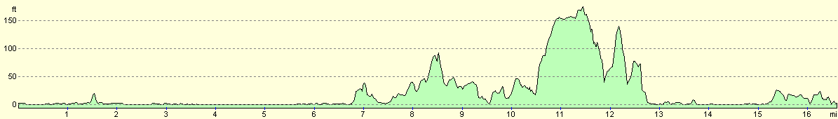
For more information on profiles, ascents and descents, see this page
Accommodation
We sent the night in the Gregory Place car park, which is near to the bridge over to the East Beach in Lossiemouth, which was a nice place to spend the night, although it was a bit noisy from the jets flying overhead.
Disclaimer
Please note that I take no responsibility for anything that may happen when following these directions. If you intend to follow this route, then please use the relevant maps and check the route out before you go out. As always when walking, use common sense and you should be fine.
If you find any information on any of these routes that is inaccurate, or you wish to add anything, then please email me.
All images on this site are © of the author. Any reproduction, retransmissions, or republication of all or part of any document found on this site is expressly prohibited, unless the author has explicitly granted its prior written consent to so reproduce, retransmit, or republish the material. All other rights reserved.
Although this site includes links providing convenient direct access to other Internet sites, I do not endorse, approve, certify or make warranties or representations as to the accuracy of the information on these sites.
And finally, enjoy your walking!
This walk was mentioned in the following routes:
| My walk around the coastline of Britain |
Nearby walks
| # | Title | Walk length (miles) |
|---|---|---|
| 545 | Nairn to Findhorn | 24.1 |
|
|

|