Walk #453: Port Logan to Portslogan Farm
 |
 |
|
General Data
| Date Walked | 25/05/2003 |
| County | Dumfries and Galloway |
| Start Location | Port Logan |
| End Location | Portslogan |
| Start time | 07.55 |
| End time | 15.25 |
| Distance | 19.5 miles |
| Description | This was quite an enjoyable walk, following the cliff top and roads northwards along the western side of The Rhins. |
| Pack | Today I carried my 30-litre Karrimor HotRock rucksack, which was filled with my packed lunch, waterproof leggings, water bottle and a couple of spare shirts, together with the usual assortment of odds and ends. |
| Condition | I feel absolutely fine after this walk, and I could easily have walked further if I had the time. I had a little problem with my little toes on my right foot, which may be because they need cutting. |
| Weather | Today was thankfully a dry day, with no sign of the rain that has blighted previous days. There was a fairly keen wind, but this did not bother me for much of the time. |
| OS map | Landranger number 82 (Stranraer & Glenluce, The Rhins) |
 |
 |
|
Map of the walk
Maps courtesy of Google Maps. Route for indicative purposes only, and may have been plotted after the walk. Please let me have comments on what you think of this new format. For a detailed table of timings for this walk, please see the table file.
 |
 |
|
Notes
We had arranged to meet an old friend of ours who was coming to visit for a day at Prestwick airport at five this evening, and so I was aware that I was going to be under pressure to get a long day in, as it was going to take us over an hour to drive to the airport. For this reason I set off early, and I was glad to see that the sun was shining over the sunken row of houses at Port Logan as I set off. Port Logan is famous for its fish pond, and it was not open as I walked past it today. The houses on the seafront are sunken to protect them from the gales that come off the sea, and it was curious to see first-floor windows at ground level.
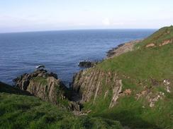
I followed the coast for the first few miles from Port Logan, initially along a road and then following the cliffs past the Mull of Logan. This was quite tiring, and as I was on a strict time schedule I chose to follow paths, tracks and roads inland of the cliffs. This led to my finding quite a nice route despite much of it being on roads, and I only rejoined the coats proper at Knockinaam Lodge, from where a path follows the cliffs northwestwards for a couple of miles to Portpatrick. On the way it passes the ruins of Dunskey Castle, which are quite impressive. Unfortunately the ruins can only be viewed from a distance as they are fenced off due to the danger of falling masonry. It would have been nice to be able to go in and explore the ruins fully, but unfortunately that was not possible.
I met Sam for lunch in a car park on the southern side of Portpatrick, and I gratefully wolfed down the sandwiches that she had made for me whilst I read the paper. I was still under some considerable time pressure, and so after a short break I set off once again. Portpatrick is a lovely little town, and I enjoyed my walk around th3e harbour, with the attractive coloured houses beside it. Portpatrick used to be the ferry port for Ireland, but it was bedevilled by southwesterly winds that made navigation difficult in storms, so the port moved the short distance to Stranraer, which is protected by Loch Ryan. The move has probably benefited Portpatrick, as it had left a very attractive town with none of the modern ugliness of a ferry port.
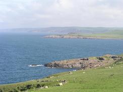
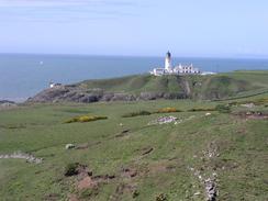
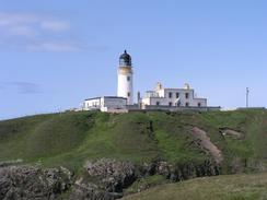
Portpatrick is also the start of the Southern Upland Way, which I followed for the first few miles along the cliffs past the Killantringan lighthouse at Black Head. In the little bay of Portamaggie below the lighthouse there were the obvious remains of a ship; the bow and stern clearly recognisable and some way away from each other. The wreck is the remains of the Cypriot registered coaster Craiganlet, which sunk on the way from Belfast Lough to Liverpool. A Royal Navy Sea King helicopter from Prestwick rescued the eleven-man crew. I was surprised to see how much of the superstructure remained intact after twenty years, and I wonder how much would remain after another twenty.
Sam picked me up on the B738 road by the farm at Portslogan, and we then had a mad drive north to Prestwick airport to meet Ben. We arrived ten minutes late, which was not bad considering the distance that we had to travel. After wards we drove back to Stranraer and found a little café in which we had some fish and chips - a bit of a treat for us, as we do not often have them. We did not fancy spending the night in a car park in the centre of town, so we drove a little way out to a lay-by beside the A77(T) in Innermessan, where we watched the sun slowly go down to the west. There are certainly worse ways to end a day, and it was nice to be able to natter to Ben about what had been going on back in Cambridge over the last eight months. I miss Cambridge a great deal, although I do not know if I miss it enough to go back there to live once the walk is finished.
 |
 |
|
Directions
This walk starts off at the car park by the pier in the little village of Port Logan. Head along the road through the village, and just beside the little hotel cum B&B turn left along the B7065. At a car park on the left turn down a track that leads to the Port Logan fish pond. From here I headed westwards paralleling the cliff top, although keeping slightly inland from it to avoid little gullies. I continued around the Mull of Logan and then headed northwards past Duniehinnie until I met the end of a public road near Port Gill.
However, the route mentioned above involves going over private land and through a garden. For this reason use the following route betwen Port Logan and Port Gill:
Head north put of Port Logan along the B7065. Continue along the road as it curves to the right to head inland, and then at NX097412 turn left along a minor road. This heads northwestwards for 1.6 miles. After 0.5 miles the road enters some woodland; the road forks shortly after it curves to the right after leaving the woods. Take the left-hand fork and continue along the road until it reaches Port Gill at NX079429.
Here I joined a track that head northwards for about a kilometre before ending at another track just to the west is Drumbreddan, from where I took another track that headed northwestwards, which also ended at a public road. I then cut cross-country over the fields, aiming for a public road, and when I met this I took the driveway that leads to the farm at Kenmuir, and when this turned to the right I continued straight on northwards across fields for about a kilometre, until I reached a track near West Ringuinea.
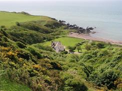
I turned right along the track for a short distance until it joined a road, and then turned left to head northwards along this road past Cairgarroch and Kirklauchline. At a triangular road junction near Neuk turn left to head in a more westerly direction, and a little under a kilometre later turn left at another road junction. Just before the road crosses the Port of Spittal Burn turn left down a surfaced track that leads for a kilometre down to Knockinaam Lodge. When the lodge is reached enter the car park to the right and join a footpath that climb back uphill onto the cliff top, which it follows past Morrach Bay and past Dunskey Castle before descending down to Portpatrick Harbour.
Walk around Portpatrick harbour until the sign that marks the start of the Southern Upland Way is reached. Climb up the steps onto the cliff top near the radio masts, and follow the Southern Upland Way for about two miles until it reaches the lighthouse at Black Head. When the access road leading to the lighthouse is reached turn right and follow the road eastwards for a little over a mile until it reaches the B738 road. Here leave the Southern Upland Way by turning left to follow the B738 road northwestwards for about a mile and half until it reaches the farm at Portslogan on the left, where this walk ends.
 |
Distances
| From | To | Distance (m) | Ascent (ft) | Descent (ft) |
|---|---|---|---|---|
| Port Logan | Portpatrick | 14.4 | 1503 | 1516 |
| Portpatrick | Portslogan Farm | 5.1 | 1043 | 804 |
This makes a total distance of 19.5 miles, with 2546 feet of ascent and 2320 feet of descent.
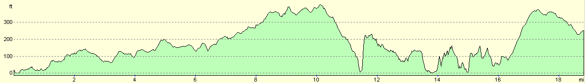
For more information on profiles, ascents and descents, see this page
Accommodation
We parked Mervan in a little lay-by beside the A77(T) to the south of Innermessan. This was right by the end of Loch Ryan, and had some great views of ferries coming in to Stranraer and Cairnryan. There were some public toilets in the lay-by, which wee actually quite clean, so in many ways this is an ideal place to spend the night.
Disclaimer
Please note that I take no responsibility for anything that may happen when following these directions. If you intend to follow this route, then please use the relevant maps and check the route out before you go out. As always when walking, use common sense and you should be fine.
If you find any information on any of these routes that is inaccurate, or you wish to add anything, then please email me.
All images on this site are © of the author. Any reproduction, retransmissions, or republication of all or part of any document found on this site is expressly prohibited, unless the author has explicitly granted its prior written consent to so reproduce, retransmit, or republish the material. All other rights reserved.
Although this site includes links providing convenient direct access to other Internet sites, I do not endorse, approve, certify or make warranties or representations as to the accuracy of the information on these sites.
And finally, enjoy your walking!
This walk was mentioned in the following routes:
| My walk around the coastline of Britain |
Nearby walks
| # | Title | Walk length (miles) |
|---|---|---|
| 451 | Auchenmaig to New England Bay | 20.0 |
| 452 | New England Bay to Port Logan | 20.9 |
|
|

|