Walk #452: New England Bay to Port Logan
 |
 |
|
General Data
| Date Walked | 24/05/2003 |
| County | Dumfries and Galloway |
| Start Location | New England Bay |
| End Location | Port Logan |
| Start time | 09.32 |
| End time | 17.13 |
| Distance | 20.9 miles |
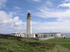
| Description | This was quite an interesting walk, and it had much less road walking than yesterday's walk. The highlight was the lighthouse at the Mull of Galloway, from where I got some great views. |
| Pack | Today I carried my 30-litre Karrimor HotRock rucksack, which was filled with my packed lunch, waterproof leggings, water bottle and a couple of spare shirts, together with the usual assortment of odds and ends. |
| Condition | I feel absolutely fine after this walk, and have no significant problems to report. The left-hand side of my neck aches slightly from where I cricked it today, but both of my ankles and my shoulder were fine. |
| Weather | Thankfully today was much better than yesterday, and I only had to put with one short rain shower. The wind was quite strong when I was in exposed places, but this was quite easy to put up with. I am just glad that it was not another wet day. |
| OS map | Landranger number 82 (Stranraer & Glenluce, The Rhins) |
 |
 |
|
 |
 |
|
Map of the walk
Maps courtesy of Google Maps. Route for indicative purposes only, and may have been plotted after the walk. Please let me have comments on what you think of this new format. For a detailed table of timings for this walk, please see the table file.
 |
 |
|
 |
Notes
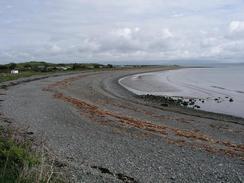
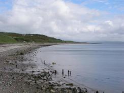
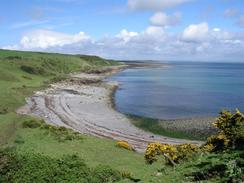
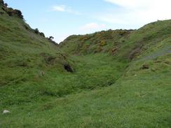
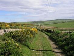
Sam was looking slightly the worse for wear after the excesses of last night when we woke up this morning, but a couple of cups of coffee woke us both up. I was getting ready to leave at about eight thirty when a heavy shower started, and I decided to delay the start until this stopped. Sam dropped me off at New England Bay, and I walked the first three and a half miles back to Drummore in trainers to save my feet. I then changed into my boot, and walked past the attractive harbour (the breakwater of which is off-limits to everyone but MOD personnel from the firing range nearby) and on southwards following the coast. Low cliffs took me past Cailiness Point and on to the caravan site at Maryport Bay, and I then followed the rocky foreshore southwards. When the foreshore became too rocky for my liking I climbed up onto the cliff top and followed this southwards to the road at East Tarbert.
I arrived at the lighthouse at the Mull of Galloway to find that it was open to the public. I decided to have a look around, as I have seen so many lighthouses on this trip but have never been into any. When I explained what I was doing on the trip the lady let me in for free, but I said hat I would put the two pounds into the charity box. I climbed up the circular staircase to the top room, and then up two ladders to reach the lamp room, from where the views were amazing. The Isle of Man was clearly visible, as was the Lake District, but Ireland and Belfast Lough were hidden in the haze. I chatted to the guide at the top of the lighthouse, who told me some of its history and of how it worked. Apparently this is the only operating lighthouse in Scotland that is open to the public, although it has been so successful they are planning to open seven more. I was amused to find that the lights that they use, instead of being one large bulb as I was expecting, was actually an array of large train headlights. I then went down to the next level, and walked around the balcony to get an unobstructed view out. Before the lighthouse was automated the weights that turned the light platform would have to be wound up by the keeper every forty-five minutes whilst the light was on, and paraffin would have to be pumped up to keep the wick burning. As well as all this, the glass would have to be cleaned every morning after the light had been burning, and in high winds little brass studs would have to be opened and closed to ensure that the wick burned evenly.
The Mull of Galloway is the most southerly point in Scotland, and this is a sure sign that the rest of my walk will all be north of here. Indeed, one gent who we met in the pub last night moved to live in Drummore from the northeast of England, and actually had to move south to live there! I was in two minds about whether or not it was worth visiting the Mull as it only had one route on or off, but I am glad that I did, as the lighthouse was a literal highpoint of the day.
I had been in two minds about whether to walk along the coast all the way to Port Logan, or whether to take an easier route. Taking roads all day was not really an option as all roads from the mull lead towards Drummore. I really did not fancy walking along the coast all the way either, as the terrain looked quite troubling, so I decided to settle on a compromise, following the coast just enough to get me to a place where roads and tracks would lead me north to Port Logan. This worked quite well, and I managed to reach Port Logan in quite good time.
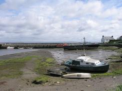
Sam was cooking dinner when I arrived at Mervan, which was parked by the little, attractive, breakwater in Port Logan. We had a lovely fry-up (a bit of a luxury for me, as we do not have fry-ups very often), and whilst we ate we watched England thrash Zimbabwe at cricket. Sam soon fell asleep, so I left her on the bed whilst I went for a walk along the breakwater to the curious little tower at it's end. When I got there I chatted to one of the fishermen sitting on the breakwater, and he told me that the tower used to house a bell that would be rung when the weather was bad to help guide boats back into the port. The tower was lovely, but unfortunately it smelt of pee, and the area inside it and around it was covered in litter. This included empty soup cans, probably from fishermen who were eating there, and it all made for quite a sad scene when close up, but a beautiful scene with the waves breaking against the breakwater and the blue sky behind it, and particularly when the sun was setting behind it.
This evening I went to the Logan Bay Inn for a quick drink so that I could use their facilities, and on the wall in the Inn was a maritime chart of the Stranraer area, including the Mull of Galloway, Loch Ryan and even part of the coast of Northern Ireland. Looking in detail at the chart, I came across a note stating that there is unexploded ordnance on the seabed in this area, which reminded me that the sea in this area was used as a dumping ground for ammunition after World War Two, and that this was now a large potential threat to the environment. The chart also showed that submarines operated in the area, and I would guess that these would have come down the Clyde and from Faslane submarine base to the north.
Directions
This walk starts off at the little picnic site by the caravan park at the south end of New England Bay. Leave the caravan park and turn left to head south down the A714 bay. Continue on down the road for over three miles until it enters the village of Drummore. Pass a pub, and then take a surface track that heads past a bollard down to the road along the foreshore. Follow this road south past the Ship Inn and on towards the quay. Continue on southwards out of the village, and when the track turns to the right turn left through a gate. Follow the edge of the fields around southeastwards until you reach a ruined building at Cailiness Point. At Cailiness Point drop down onto the foreshore if the tide is out and follow this southwestward along the edge of Maryport Bay.
Pass the caravan site at Maryport Bay and continue on along then increasingly rocky foreshore. At about grid reference NX 141330 the cliffs become too rocky, so I ascended them using an obvious route and then walked along the cliff top southwards past Portankill and Mull of Galloway Farm towards East Tarbert. At East Tarbert I joined the road, and turned to the left to walk eastward for a mile towards the lighthouse at Mull of Galloway.
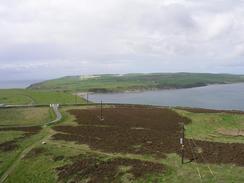
From the Mull of Galloway turn around and head back towards East Tarbert, and then turn left to leave the road and walk westwards along the top of the cliffs. Cross one small stream in a valley and then a dry valley, and continue on along the cliffs until you are at about grid reference 131312. Here turn right to leave the cliff edge and head north to join a track that ends at a T-junction with a road at West Cairngaan Farm. Turn left along the road to Cardrain Farm; pass through the farm and then turn right to head northwards along a track. At Pulinkum Farm turn left along another track that westwards until it ends at a T-junction with another road. Cross the road and head straight on across fields. I found it easiest to keep the field boundaries to my left. Eventually a track is reached; turn right along this track and follow it past the farm at Aucheneight, and then turn right to head northwards along a track until it end at a T-junction with a road.
Turn left along this road and follow it northwestwards past Inshanks and then westwards. The road curves around to the right to head northwards past the farm at Knockncule, before it turns to the right to head eastwards. The road climbs uphill for about a mile past Cairn Fell, and when a track leads off to the left head northwards along this track, which passes to the east of Cairn Fell before descending down to the farm at Castle Clanyard. Here the track turns to the right and descends to meet a road at Low Clanyard.
Continue on along the road past the rather unsubstantial remains of a castle, and when the road curves to the right continue straight on along a track that heads uphill and curves slightly to head northwestwards. The track is always visible on the ground, but it becomes increasingly indistinct before it joins a more distinct track after a mile and a half. A short distance along this new track turn to the left to head downhill to the north for a little under a kilometre down into Port Logan. This walk ends in the car park by the breakwater by the village, where the track emerges out onto a road.
Distances
| From | To | Distance (m) | Ascent (ft) | Descent (ft) |
|---|---|---|---|---|
| New England Bay | Drummore | 3.7 | 292 | 259 |
| Drummore | Mull of Galloway | 6.1 | 669 | 463 |
| Mull of Galloway | Port Logan | 11.1 | 1079 | 1312 |
This makes a total distance of 20.9 miles, with 2040 feet of ascent and 2034 feet of descent.
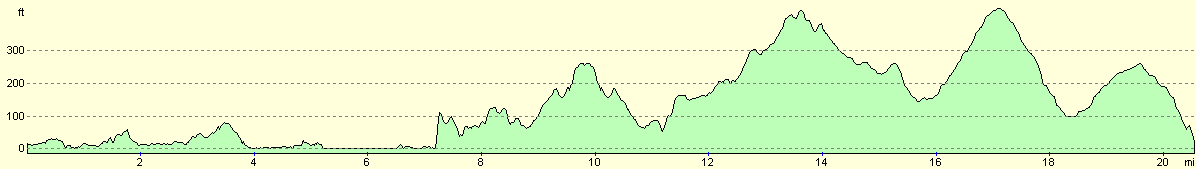
For more information on profiles, ascents and descents, see this page
Accommodation
We parked Mervan in a little car park by the breakwater in Port Logan, which was quite handy for the local pub.
Disclaimer
Please note that I take no responsibility for anything that may happen when following these directions. If you intend to follow this route, then please use the relevant maps and check the route out before you go out. As always when walking, use common sense and you should be fine.
If you find any information on any of these routes that is inaccurate, or you wish to add anything, then please email me.
All images on this site are © of the author. Any reproduction, retransmissions, or republication of all or part of any document found on this site is expressly prohibited, unless the author has explicitly granted its prior written consent to so reproduce, retransmit, or republish the material. All other rights reserved.
Although this site includes links providing convenient direct access to other Internet sites, I do not endorse, approve, certify or make warranties or representations as to the accuracy of the information on these sites.
And finally, enjoy your walking!
This walk was mentioned in the following routes:
| My walk around the coastline of Britain |
Nearby walks
| # | Title | Walk length (miles) |
|---|---|---|
| 451 | Auchenmaig to New England Bay | 20.0 |
|
|

|