Walk #413: Beaumaris to Penmaenmawr
 |
 |
|
General Data
| Date Walked | 14/04/2003 |
| County | Anglesey, Gwynedd, Conwy |
| Start Location | Beaumaris |
| End Location | Penmaenmawr |
| Start time | 08.28 |
| End time | 16.20 |
| Distance | 18.1 miles |
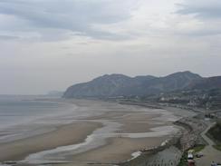
| Description | This was a lovely little walk, with some lovely views across the Menai Straits, over to Puffin Island and along to Great Orme's Head. |
| Pack | Today I carried my 30-litre Karrimor HotRock rucksack, which was filled with my packed lunch, waterproof leggings, water bottle and a couple of spare shirts, together with the usual assortment of odds and ends. |
| Condition | I feel absolutely fine after this walk, and I have no significant problems to report. In fact I could easily have walked further if I had required, but there was nowhere convenient that I could see on the map to be picked up. |
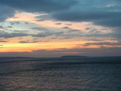
| Weather | The weather today was quite varied; there were some long sunny periods but also some of scattered cloud, one of which gave a short drizzle shower that did not last long enough for me to put my coat on. Later on in the afternoon it got quite warm, and even the light wind was warm. All in all it was a lovely day, and indeed Northwest Wales was apparently the warmest part of he country today, and this good weather looks set to continue. |
| OS map | Landranger number 115 (Snowdon & surrounding area) |
 |
 |
|
 |
 |
|
Map of the walk
Maps courtesy of Google Maps. Route for indicative purposes only, and may have been plotted after the walk. Please let me have comments on what you think of this new format. For a detailed table of timings for this walk, please see the table file.
 |
 |
|
Notes
There was a great deal of road walking on today's walk, but I really did not mind this as it allowed me to walk reasonably fast without putting myself under strain. The initial section of the walk from Beaumaris to Menai Bridge was a fairly boring and uninteresting slog along the AA545 road, and I was quite glad when I reached the bridge. Reaching the bridge meant that I had finished walking around the Isle of Anglesey, but I was more interested in studying the bridge than celebrating.
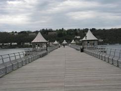
I met Sam by the pier in Bangor, and after she had parker Mervan down the road we set off to walk down the pier together. The pier is a gem, an extremely nice example and is quite long, sticking out halfway across the Menai Straits. It is also quite un-commercialised, with no fruit machines or children's rides on it. I find it quite amazing that other piers used to look like this but have been spoilt by being commercialised. The pier cost us twenty-five pence each to walk along, which we were both more than willing to pay. After we left the pier we decided to go into a pub so that we could use their facilities; the first two that we tried were shut, but the third, the Union Tavern, was open. We spent quite a while inside whilst I drank a pint, looking at the varied ephemera on the walls before I went out to continue on the walk.
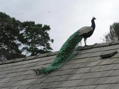
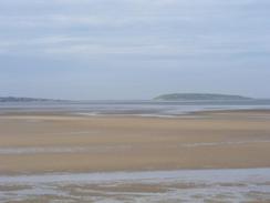
I had been hoping that I may have been able to walk through the grounds of Penrhyn Castle, so I diverted off route to have a look at the nearest entrance gateway. There was a large sign stating no entry, and as I was looking a Land Rover came roaring out of it, so I decided not to risk it and to do the longer walk around the park. There was one good thing about this diversion; I got to see two Peacocks strutting about nearby, the first peacocks that I have seen on this trip. Once I had made my way back to the coast the sun was shining hard down, and I got some beautiful views across to the lighthouse on Puffin Island and along to Great Orme's Head, both of which stood out against the blue sky.
As I was walking I was trying to work out if the walk around Anglesey had been worth the time that it had taken. On one hand the scenery was quite spectacular in places, and on the other some parts of it were not very spectacular and the path was hard to find. On the whole, though, I am glad that I walked around the island. I have many happy memories from it, and it makes the map of Wales generated from my walks look more complete. I do feel strangely unsatisfied, however; this could be because after waking for a week I have ended up exactly where I was, and hence not progressed any further around the coast.
I met Sam in Llanfairfechan, and we sat down outside a café and had an ice-lolly each whilst we soaked up the sun. As I was sitting down I decided to walk further, and to meet Sam at Penmaenmawr. I had been unsure about how to get between the two villages as the road and railway are squeezed between the sea and a mountain. There are two roads (each carrying two lanes of a dual carriageway), and both of them plus the railway run through tunnels. Sam had driven through the road tunnels and had found out that pedestrians can walk along a pavement beside the eastbound carriageway. This road was built in 1935 to replace the earlier road built by Telford, and has two small tunnels carrying it through the headlands. Below it and to the seaward side is the railway line, and above it and to landward is the new section of dual carriageway built in the eighties. One thing that amused me was a concrete horse-mounting block at the entrance of the new tunnel; a cycle path goes above this new tunnel (bikes and horses are not allowed along the pavement that I walked along).
When I reached Mervan I was very tempted to continue on further towards Conwy. I was feeling fit, and after ten minutes rest I had the energy. After some prevarication I decided not to, however; there was nowhere convenient that I cold be picked up without walking about four miles, and I also did not want to place too much extra strain on my body after the problems that I had last week.
I am quite looking forward to tomorrow's walk - I will be walking past Conwy Castle and across the adjacent suspension bridge, which are both architecturally interesting, and I shall also be walking around the imposing headland of Great Orme's Head.
Directions
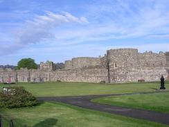
This walk starts off by the castle in Beaumaris. Leave the car park and walk to the promenade that runs along the seafront in the town. Turn right to follow this promenade southwestward past the pier until it ends at a road. Follow this road around until it ends at a T-junction with the A4545 road. Turn left and follow this road southwestward for nearly four miles, passing Gallows Point and entering Menai Bridge before reaching a roundabout with the A5. For most of this distance there is a pavement beside the road, but there is a significant stretch where this is not; fortunately the traffic was not too busy despite the fact that I was walking along it in the rush hour.
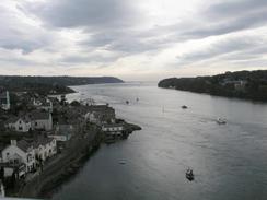
At the roundabout turn left to cross the Menai Suspension Bridge over the Menai Straits. On the mainland the road meets a roundabout; here turn left to walk northeastwards along the A5 road. When the road curves around to the right in Upper Bangor turn left down a road that contuse northeastwards for a little under a mile until Bangor pier is reached. Follow the road as it curves around to the right to end at the A5 once more.
Follow the A5 as it heads southeastwards for a couple of miles, passing a crematorium. When a roundabout is reached near the main entrance to Penrhyn Castle turn left along a minor road that heads towards Tal-y-bont. I took the first road off to the left, which heads through an attractive little village following a cycle route before curving around to pass the church and reaching the road by a bridge over the Afon Ogwen. Cross the bridge and continue on. The road crosses a railway line on a bridge, and immediately after this bridge a road leads off to the left. Take this road and follow it northwards for a mile until it ends at a car park near Aber-Ogwen.
From the car park turn right to head eastwards along the coast. The path heads along the foreshore initially, so if the tide is high this could be difficult, but after a while a path becomes available immediately behind the beach. Follow this eastwards along the coast (although the path sometimes disappears for short stretches and you have to walk along the shingle beach) past Abergwyngreyn until it reaches the sea front in Llanfairfechan. Walk along the seafront until the promenade ends, and then climb up to join a footpath beside the eastbound carriageway of the A55 road. Follow the road eastwards, and it heads through two short tunnels. After the second tunnel the pavement ends and you have to cross the westbound carriageway and head for a short distance up a road that leads into Penmaenmawr before turning left down a footpath that leads downhill under the roads and ending at a track beside the sea. At this road turn right and follow it for about a hundred yards to a car park, where this walk ends.
Distances
| From | To | Distance (m) | Ascent (ft) | Descent (ft) |
|---|---|---|---|---|
| Beaumaris | Bangor | 7.0 | 850 | 869 |
| Bangor | Penmaenmawr | 11.1 | 715 | 689 |
This makes a total distance of 18.1 miles, with 1565 feet of ascent and 1558 feet of descent.
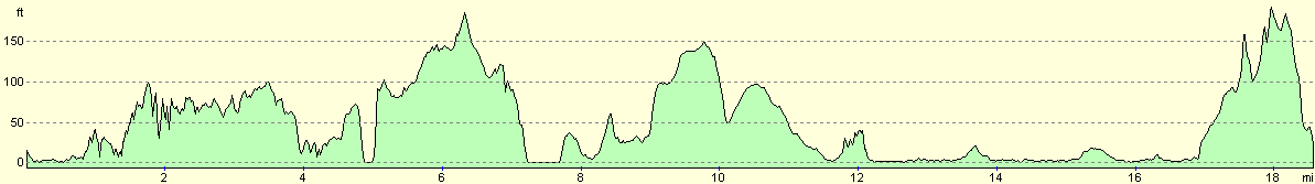
For more information on profiles, ascents and descents, see this page
Accommodation
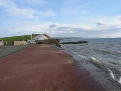
We parked Mervan in a car park trapped between the sea and A5 dual carriageway in Penmaenmawr. This was a noisy place to park and was quite a walk to the nearest facilities, but we were both too hot and tired to be bothered going anywhere.
Disclaimer
Please note that I take no responsibility for anything that may happen when following these directions. If you intend to follow this route, then please use the relevant maps and check the route out before you go out. As always when walking, use common sense and you should be fine.
If you find any information on any of these routes that is inaccurate, or you wish to add anything, then please email me.
All images on this site are © of the author. Any reproduction, retransmissions, or republication of all or part of any document found on this site is expressly prohibited, unless the author has explicitly granted its prior written consent to so reproduce, retransmit, or republish the material. All other rights reserved.
Although this site includes links providing convenient direct access to other Internet sites, I do not endorse, approve, certify or make warranties or representations as to the accuracy of the information on these sites.
And finally, enjoy your walking!
This walk was mentioned in the following routes:
| My walk around the coastline of Britain |
Nearby walks
| # | Title | Walk length (miles) |
|---|---|---|
| 405 | Snowdon Ranger to Caernarfon via Snowdon | 16.2 |
| 406 | Caernarfon to Barras | 17.1 |
| 412 | Moelfre to Beaumaris | 18.1 |
|
|

|