Walk #353: Porthcothan to Wadebridge via Padstow
 |
 |
|
General Data
| Date Walked | 11/02/2003 |
| County | Cornwall |
| Start Location | Porthcothan |
| End Location | Wadebridge |
| Start time | 08.38 |
| End time | 16.05 |
| Distance | 18.3 miles |
| Description | This was a highly enjoyable walk of two halves; an initial walk along the South West coast Path to Padstow was followed by a gentle stroll along the Camel Trail to Wadebridge. |
| Pack | Today I carried my 30-litre Karrimor HotRock rucksack, which was filled with my packed lunch, waterproof leggings, water bottle and a couple of spare shirts, together with the usual assortment of odds and ends. |
| Condition | My left ankle is aching slightly after this walk, but this is probably to be expected after a walk of this length. Aside from this I am absolutely fine, and could easily have walked further if I had needed. |
| Weather | The weather today was a vast improvement on yesterday's, and it remained dry all day. There were also long periods of sunshine that made for some absolutely glorious views. There was not much wind, and it was quite mild for the time of year. |
| OS map | Landranger number 200 (Newquay & Bodmin, Camelford & St Austell) |
 |
 |
|
 |
 |
|
Map of the walk
Maps courtesy of Google Maps. Route for indicative purposes only, and may have been plotted after the walk. Please let me have comments on what you think of this new format. For a detailed table of timings for this walk, please see the table file.
 |
 |
|
 |
 |
|
Notes
Today started off fairly inauspiciously, as when I got out of the van I noticed that the bottom of my rucksack was damp. I assumed that this was due to the fact that the bottom of the sack had not dried off after yesterdays soaking, and so I did not investigate further. Unfortunately five minutes later as I was climbing up onto the cliffs I noticed that my bottom was wet. I stopped and took my bag off to find that the top of my Platypus water bottle on properly and that it had come off. About a third of the water had leaked out of the platypus and the base of the rucksack was filed with a mixture of water and Isotar. Swimming happily around in this was my lunch, so at lunch I had some lovely soggy sandwiches to eat.
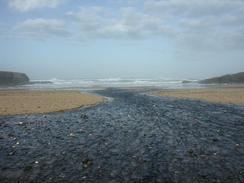
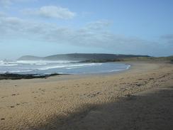
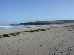
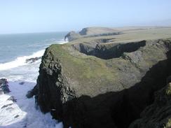
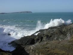
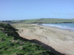
The waves along the cliffs as far as Stepper Point were quite spectacular, and on occasion I would stop to see wave after wave come in and the spray come over the cliffs. They were particularly spectacular on the Middle Merope Island, which waves were breaking over the edge of it at times in a quite beautiful display of the power of the sea. Once I had passed Stepper Point and gone into Padstow Bay the waves calmed down, and by the time I reached Padstow the sea was quite calm - a very marked difference to the sea a little further back along the coast.
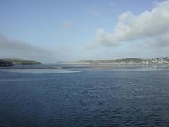
When I got to Padstow I met Sam beside the harbour, and we went to a local pub, the Blue Lobster, where I had a pint whilst we sorted out some correspondence that we had to post. This made for a nice little break, although I did not have too far to walk afterwards. Padstow itself is an absolutely superb little town. I had been very impressed with it the first time that I walked through it, and today just cemented that opinion in my mind. As I approached the town I could see the ferry that takes passengers over to Rock, on the eastern bank of the river, ply its trade. I travelled over the river on this ferry in 2000, and enjoyed the short journey massively. The ferry reminds me of an old marine troop landing craft, with a large ramp at the front that lowers down onto the beach or harbour ramp when it lands.
After we had finished the drink we went for a little walk around the town on a little quest to find Rick Stein's restaurant, shop and cafe. Both Sam and her father are massive fans of Rick Stein, and I took some photographs of her outside the various buildings before buying her dad a present in the shop. I then decided that as it Valentine's Day on Friday I would treat Sam out for a meal in the cafe tonight. This was an absolutely superb night out, and we enjoyed the food and the very nice (and also fairly expensive) bottle of wine. The food was excellent, and it was a night that I shall remember for some time.
The walk from Padstow to Wadebridge was nice and easy, and I put myself on autopilot as there was nothing that could possibly trip me up on the flat surface designed for ease of cycling. I listened to the next tape of Simon Schama's 'History of Britain' as I walked, and let my imagination roam free as I daydreamed about the Battle of Hastings and King John. Sam was waiting for me in the Lidl car park in Wadebridge, and she joined me as I walked for the last couple of hundred yards to the Old Bridge in the town, which before the new road bridge was built slightly downstream was the first crossing point of the Camel.
I have now finished the third guidebook about the South West Coast Path, and tomorrow when I reach Rock I shall start on the fourth and final one. The start of the South West Coast Path in Poole on January the Second seems such a long time ago, and I have walked an awfully long way since then. The walk is going far better than I could possibly have expected, and I can only hope that this remains to be the case for the rest of the trip.
Directions
| During this walk I followed the South West Coast Path, the route of which is detailed in the Ordnance Survey National Trail Guide 9, Padstow to Falmouth (ISBN 1-854108-50-6). Unfortunately the route description is written in reverse to the direction that I am walking, but the 1:25,000 maps in the book are clear and the signs on the ground are very good. Also to be recommended is the South West Coast Path Association guidebook (ISBN 0-907055-04-4), which has less concise directions and no maps, but includes accommodation details and grades each section of the walk according to difficulty. They also publish reverse directions, which are suitable for walking in the direction that I walked the route. They have a website at www.swcp.org.uk, which is well worth a visit. | 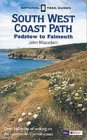
|
| 
| |
| |
| |
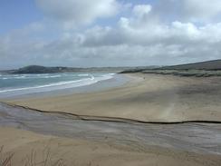
The second section of the walk between Padstow and Wadebridge follows the Camel Trail, which makes for some very easy walking. This trail runs along the route of the old Padstow to Wadebridge railway line, which has been converted into a multi-use path and therefore makes for some very easy and flat walking. When you reach the centre of Padstow simply follow the river downstream through the town until you reach the old station site, which is where the trail starts. Follow the trail for five and a quarter miles until it ends in Wadebridge, and then follow the road for a few hundred yards to the Old Bridge over the river in the town.
Distances
| From | To | Distance (m) | Ascent (ft) | Descent (ft) |
|---|---|---|---|---|
| Porthcothan | Padstow | 12.6 | 2028 | 2021 |
| Padsstow | Wadebridge | 5.7 | 20 | 20 |
This makes a total distance of 18.3 miles, with 2048 feet of ascent and 2041 feet of descent.
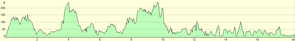
For more information on profiles, ascents and descents, see this page
Accommodation
We spent the night in the top car park in Padstow, which was an easy stagger uphill from the restaurant. There is no overnight sleeping in this car park, but we decided to do our normal policy and totally ignore this.
Disclaimer
Please note that I take no responsibility for anything that may happen when following these directions. If you intend to follow this route, then please use the relevant maps and check the route out before you go out. As always when walking, use common sense and you should be fine.
If you find any information on any of these routes that is inaccurate, or you wish to add anything, then please email me.
All images on this site are © of the author. Any reproduction, retransmissions, or republication of all or part of any document found on this site is expressly prohibited, unless the author has explicitly granted its prior written consent to so reproduce, retransmit, or republish the material. All other rights reserved.
Although this site includes links providing convenient direct access to other Internet sites, I do not endorse, approve, certify or make warranties or representations as to the accuracy of the information on these sites.
And finally, enjoy your walking!
This walk was mentioned in the following routes:
| My walk around the coastline of Britain |
| South West Coast Path |
Nearby walks
| # | Title | Walk length (miles) |
|---|---|---|
| 81 | Newquay to Padstow | 14.5 |
| 82 | Padstow to Port Isaac | 11.1 |
| 83 | Port Isaac to Boscastle | 13.5 |
|
|

|