Walk #361: Saunton to Ilfracombe
 |
 |
|
General Data
| Date Walked | 19/02/2003 |
| County | Devon |
| Start Location | Saunton |
| End Location | Ilfracombe |
| Start time | 09.03 |
| End time | 15.41 |
| Distance | 16.0 miles |
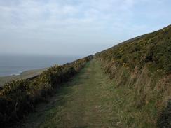
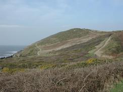
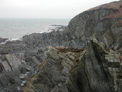
| Description | This was a lovely walk with some nice, unstrenuous walking over cliffs and along the beach past Woolacombe. |
| Pack | Today I carried my 30-litre Karrimor HotRock rucksack, which was filled with my packed lunch, waterproof leggings, water bottle and a couple of spare shirts, together with the usual assortment of odds and ends. |
| Condition | I feel absolutely fine after this walk, and have no problems to report. There has been a few days now where I have been able to walk with no problems, and this is making me feel more confident. |
| Weather | At last there was a change in the weather today. It was far cloudier than it has been with less sunshine, but the temperatures were not much warmer. The worst thing was the wind, which was stronger then it has been for some time and was particularly noticeable around Baggy Point. Fortunately it was not wet, the fifth or sixth day in a row where I have not had any rain. |
| OS map | Landranger number 180 (Barnstable & Ilfracombe, Lynton & Bideford) |
 |
 |
|
 |
 |
|
Map of the walk
Maps courtesy of Google Maps. Route for indicative purposes only, and may have been plotted after the walk. Please let me have comments on what you think of this new format. For a detailed table of timings for this walk, please see the table file.
Notes
I really found it hard to believe that this was a sixteen-mile walk, as I felt like it was much shorter than this. I got to Woolacombe in double-quick time, and I was surprised to find that this stretch of the walk was around eight miles long. I measured the map after the walk and came up with the same value as quoted in the South West Coast Path guidebook, so I assume that it must be more or less correct.
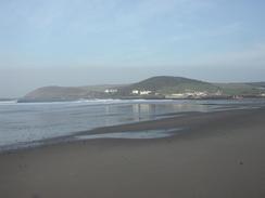
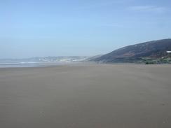
The walk along the beach at Woolacombe was very nice, and I played a few little games with myself as I strode along the two miles of beach. I enjoy looking behind me as I walk and see how straight my track through sand is; it is amazing hoe much you go from side to side as you walk along what you think is a straight line on a beach. I met Sam in Woolacombe, and I ate my sandwiches in the van, and this was nice as it got me out of the wind. It is really nice that there are enough daylight hours for me to take a long lunch break, and it is also very enjoyable meeting Sam at lunchtime. This situation is only going to get better from now on as I go further up the country and the days get increasingly longer. I daresay that when I got nineteen hours of daylight when I am in the north of Scotland I will wish that there was less daylight!
As I was walking from Woolacome to Morte Point I passed a man who was singing what I can only assume was some form of opera. He had a young child walking beside him and he was belting out the songs as he walked. This was quite strange, but I cannot really complain, as he did not have a bad voice, at least as my untrained ear could tell. It was quite a strange little situation, as I sometimes hear people singing as I walk (and indeed I often sing myself), but rarely do I hear someone with such a fine, strong, voice.
I got to Ilfracombe fairly early and was tempted to continue on as far as Combe Martin, another five miles further on, but decided that it would be too long a day. Instead I went with Sam into a little Internet place in the town and spent a pleasant hour answering emails and chatting to Terry on Mono, a bulletin board that I have been a member of for over ten years. As I was doing this I started to have severe Internet withdrawal symptoms, and I really wish that I could have a full Internet connection in the van. One of the annoying things about this walk is that if I had left it another year or two before doing this walk then the new 3G GPRS phones that are being released this year would have been usable on a trip like this. Instead I have to rely on finding libraries or Internet Cafes as often as possible.
Sam arranged for me to have another radio interview with BBC Radio Devon tonight, and so we waited to record the interview at six twenty in the evening. This turned out to be a reasonable interview, and it was a nice way to end the section of the trip through Devon - the day after tomorrow I shall be saying goodbye to this lovely county and into Somerset. I am still quite nervous about radio interviews, but I am finding them easier as I do more of them.
Tonight I phoned Graham Harbord, a gent who is walking the other way around, an we chatted for over half an hour about the walk. It is great to talk to someone who is doing the same thing as me, and we covered lots of topics, including the obligatory topic for long distance walkers, how we measure the distance walked. It sounds like he is getting on quite well, and he is currently in Filey - a long way from where we met in Brighton!
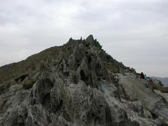
Tomorrow I have decided to try and do a strenuous walk, and I have hills like the Great Hangman (the highest point on the entire South West Coast Path) to climb. Fortunately the scenery should compensate for this, as I shall also be passing through areas such as the Valley of Rocks.
Directions
| During this walk I followed the South West Coast Path, the route of which is detailed in the Ordnance Survey National Trail Guide 8, Minehead to Padstow (ISBN 1-85410-774-7). Unfortunately the route description is written in reverse to the direction that I am walking, but the 1:25,000 maps in the book are clear and the signs on the ground are very good. Also to be recommended is the South West Coast Path Association guidebook (ISBN 0-907055-04-4), which has less concise directions and no maps, but includes accommodation details and grades each section of the walk according to difficulty. They also publish reverse directions, which are suitable for walking in the direction that I walked the route. They have a website at www.swcp.org.uk, which is well worth a visit. | 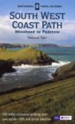
|
| 
| |
| |
| |
Distances
| From | To | Distance (m) | Ascent (ft) | Descent (ft) |
|---|---|---|---|---|
| Saunton Beach | Woolacombe | 8.0 | 1299 | 1289 |
| Woolacombe | Ilfracombe | 8.0 | 2290 | 2343 |
This makes a total distance of 16.0 miles, with 3589 feet of ascent and 3632 feet of descent.
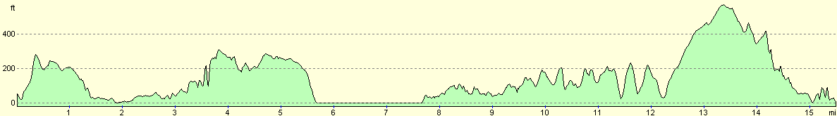
For more information on profiles, ascents and descents, see this page
Accommodation
We parked at a car park beside the tourist information office in Ilfracombe, which was a reasonably nice and quiet place to park. We were stuck right underneath a large cliff, yet we had perfect mobile and reasonable television reception. I am unsure about whether we can park here overnight and sleep in the van (and indeed I doubt we can), but I have not seen a sign forbidding it.
Disclaimer
Please note that I take no responsibility for anything that may happen when following these directions. If you intend to follow this route, then please use the relevant maps and check the route out before you go out. As always when walking, use common sense and you should be fine.
If you find any information on any of these routes that is inaccurate, or you wish to add anything, then please email me.
All images on this site are © of the author. Any reproduction, retransmissions, or republication of all or part of any document found on this site is expressly prohibited, unless the author has explicitly granted its prior written consent to so reproduce, retransmit, or republish the material. All other rights reserved.
Although this site includes links providing convenient direct access to other Internet sites, I do not endorse, approve, certify or make warranties or representations as to the accuracy of the information on these sites.
And finally, enjoy your walking!
This walk was mentioned in the following routes:
| My walk around the coastline of Britain |
| South West Coast Path |
Nearby walks
| # | Title | Walk length (miles) |
|---|---|---|
| 87 | Horns Cross to Barnstaple | 17.2 |
| 88 | Barnstaple to Woolacombe | 11.9 |
| 89 | Woolacombe to Combe Martin | 13.0 |
|
|

|