Walk #783: The Ridgeway: Goring to Ledge Hill
 |
 |
|
General Data
| Date Walked | 25/08/2007 |
| County | Oxfordshire, Buckinghamshire |
| Start Location | Goring station |
| End Location | Ledge Hill |
| Start time | 09.06 |
| End time | 19.38 |
| Distance | 24.0 miles |
| Description | This was a pleasant but long walk following the Ridgeway path northeastwards from the Thames. |
| Pack | Today I carried my MacPac rucksack, containing my light Jack Wolfskin tent and full camping equipment. |
| Condition | I am very tired after this walk, but aside from that have no significant problems to report. |
| Weather | Today was a bright, sunny day, and was quite warm throughout - it must have been one of the hottest days of the year so far. There was not much of a breeze to cool me down, and there were few clouds in the sky. |
| OS map | Landranger number 174 (Newbury & Wantage, Hungerford & Didcot), Landranger number 175 (Reading & Windsor, Henley-on-Thames & Bracknell) and Landranger number 165 (Aylesbury & Leighton Buzzard, Thame & Berkhamstead) |
 |
 |
|
 |
 |
|
Map of the walk
Maps courtesy of Google Maps. Route for indicative purposes only, and may have been plotted after the walk. Please let me have comments on what you think of this new format. For a detailed table of timings for this walk, please see the table file.
 |
 |
|
 |
 |
|
Notes
In June last year I walked the first half of the Ridgeway National Trail from Avebury to Goring on the Thames, and back then it had been my intention to walk the next two days to the end of the trail within a few weeks. Unfortunately that did not turn out to be the case, and I never quite got around to doing it. However, as I will soon be moving out of the Cambridge area, and it was one that I wanted to get out of the way before I leave, and so at five this morning I got up and prepared for the long weekend ahead. As it is a bank holiday I decided to go out for all three days, continuing on from the end of the Ridgeway to do the first day of the Icknield Way.
The journey went well, and soon I was on the train that would take me from Paddington to Goring, a slow train that stopped at may stations on the way. There was a lady sitting opposite me on the train, and we chatted about walking before the train pulled into Goring and I had to leave. As I had been sitting down for over three hours I initially walked slowly to warm my legs up, taking my time as I headed through the pleasant little village. There was a shop on the way, so I bought a can of Red Bull that I drank as I made my way towards the river.
My pack was full with camping equipment and was heavy on my shoulders as I walked along the road. It was not too far to the river, where I could join the Ridgeway trail as it headed north, initially along a path before joining a series of roads. That paralleled the river. There was a surprising amount of climbing and falling, and the views towards the river were sparse due to the houses between the road and the river.
This was a shame, but things improved when the path finally joined the floodplain for the last stretch towards South Stoke. On the way there was a broad track that was coming up from the river and heading towards a bridge under the railway line; I guessed that this was part of the works to tunnel under the river that I had passed at the end of last year when walking the Thames Path. This led me onto the road in South Stoke and past the pretty church; there were a few people out and about on what was turning out to be an absolutely superb morning, weather-wise.
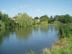
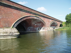
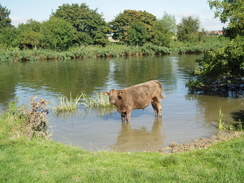
Shortly after the church a lane took me back down towards the Thames, and for the first time in the day I get a good, unobstructed view of the river. On the other side of the river was the hotel where the Thames path rejoined the river after making a diversion into a village, and the sight brought back pleasant memories of that previous walk. The path then followed meadows across the river, and the wet grass made me glad that I had put my gaiters on. There were a couple of fishermen sat beside the river and a few boats on it, but despite this I did feel pleasantly alone. Soon the path approached a large and impressive railway viaduct with low curved arches, and I studied the construction of the skew-arch brick structure (which is actually two viaducts side-by-side) as I passed underneath.
The path followed the river for a little longer, before heading inland slightly to reach the village of North Stoke and passing through the churchyard, past the pretty little church. From here a track leads northwards, again unfortunately inland away from the river, spoiling most of the available views. Just before the A4130 was reached the Ridgeway turned sharply to the right passing two horse-mounting blocks on the way - it is unusual to see two of them in the same place. As I walked I listened to Radio Five, and there was a news flash that a young Queens Park Rangers football player had died in a car crash overnight - a sobering thought.
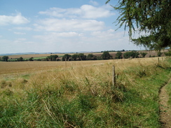
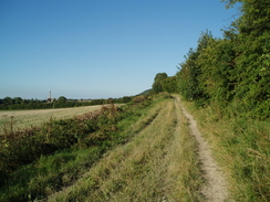
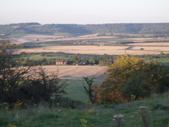
The sound from the traffic was annoying, and it was a relief when the path finally crossed he road and climbed, leaving it behind. The extra ascent started to give some superb views back to the north and west over the floodplains, and I kept on looking over my shoulder to study these as I strolled along a small bank, the Iron-age Grim's Ditch, which at this western end was not too impressive. It was a pleasant walk, far better than the first six miles had been, and the path passed a trig pillar before dropping down to a road at Cart Gap.
Underfoot the path was fairly uneven, climbing and falling a foot at a time as it headed arrow-straight across the countryside. Slowly Grim's Ditch started to become more impressive in scale, although in many places the ditch was full of vegetation that helped hide the depth of the structure. By the time that it dropped down into Morrell's Bottom it was clearly a ditch and bank, and the path swapped banks a couple of timed before eventually climbing up the centre of the ditch until suddenly it ended on a hill.
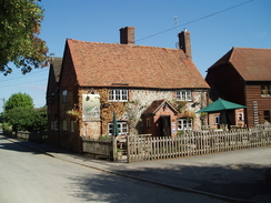
The path diverted away to the left, still climbing and giving me views back westwards, and Didcot Power Station was clearly visible on the plain in the distance. The path ended at a road that passed a church before cutting across fields and a golf course on Nuffield Common to reach the A4130 road. Here I diverted off the path for a few yards to reach the pub that was marked on the map. Thankfully this was open, and I headed into the cooler interior, which was fairly neat and tidy. I ordered my usual drinks - a pint of bitter and one of orange and lemonade - before heading out into the garden.
Fortunately there were sun shades over some of the tables, and I sat down at one, the relief at having the heavy rucksack off my shoulders being palpable. There had been papers available inside the pub, and I took the Independent out with me to read as I drunk my drinks. The pub slowly got busier, and I looked with envy at the people who had ordered food, and who were eating what looked like superb meals. I was not that hungry, however, and I did not want to have too much to eat considering the distance that I still had to walk today.
After getting my water bottle filled up again I headed off along the path, through what was the hottest part of the day. Initially I was protected from the sun by the trees as the path descended, but at the bottom of the hill the trees were left behind and a slow ascent up fields started. I was soon sweating away, and set my pace slow enough to ensure that I did not suffer too much. It was the sort of day where four or five degrees less temperature would have made it much nicer, as would more wind to help cool me.
I was beginning to suffer from the heat by the time that I reached Ewelme, and I stopped here for a minute or two to chat to a couple of gents who were walking in the opposite direction. A path took me downhill towards a road and then onto the tiny little church in Swyncombe, where an elderly nun was climbing out of a car. It was a pleasant little location, but I pressed on along the road, passing a motor home that was parked beside the road with a running club banner draped over the fence alongside.
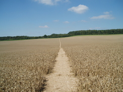
At the end of the road a path descended into a little valley before climbing up the other side; in the heat this climb was hard and had me really sweating, so it was a relief when, at the top of the climb, the path entered some woodland that protected me from the worst of the heat. Near North Farm there was a couple picking blackberries, and at the farm I started the long, straight path that would lead me towards Chinnor. The going underfoot was good and there was little ascent or descent, and as I plodded on a couple of runners came past, numbers taped onto their chests as they sweated heavily in the heat.
Southeast of Watlington there was a campsite beside the path that was bustling, but if I was to complete the Ridgeway in two days then I would need to walk further. A steady stream of runners started coming past, many singly but several couples. They were of both sexes and of all ages, but as more came past they seemed to go slower and slower until most were walking past me. I stopped one of them who told me that they were running the entire Ridgeway, the official rules gave them twenty-nine hours in which to do it, but the heat was obviously affecting some of them badly. It is a task that I would never be able to do, and I found myself full of admiration for them.
In places there were some reasonable views, but as the path was running at the base of the hills it was mostly a pleasant plod along the tracks. The authorities have stopped four-wheel drives from going along the tracks at certain times of the year, and this has obviously prevented much of the erosion that has occurred on other such tracks that I have walked along. By this time I was tired, and so I stopped off in a clump of trees beside the track, took my pack off and ate the last of my sandwiches whilst runners came past. A couple of these stopped to talk to me, and both were finding the run hard going.
As the track approached the M40 there was a large lump of runners came past me, along with a couple of walkers who were doing the trail but obviously did not want to stop. After the tunnel under the M40 the number of runners reduced, until one was seen by the A40 crossing, and then another a little further along. At the next road there was a car, a table and a few people sitting around, a checkpoint for the runners. They told me that all of the runners had come through except for one, who had had his flight from the US delayed and had set off two hours late.
By this time it was starting to get cooler as the afternoon became evening, and to my left there was an old railway line that soon diverted off to head towards Chinnor. Lakes soon appeared on either side of the track, the remains of old chalk pits, and soon afterwards I reached my target for the day, Chinnor. I was very hot and tired by now, so when a bench was reached shortly after a road I sat down and relaxed, watching a balloon float by to the north. At this point a runner came past, and I watched him jog past wondering if he would make it to the finish.
There was not really anywhere suitable to camp and there was still a couple of hours until dark, and so I continued on. The long straight track that the trail followed for the last few miles was left behind as another track took me uphill through trees on the edge of some woodland, and I started keeping a lookout for a good place to camp for the night. The woodland did not look too inviting, and so I crossed a field that had containers of feet dip beside the stiles, a sign of concern about the recent outbreak of foot and mouth disease in Surrey.
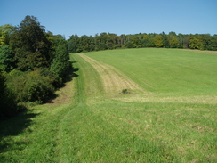
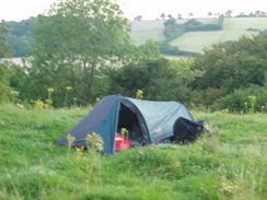
Ahead I could see Ledge Hill, which the trail would climb before starting the descent to Princes Risborough. The path crossed another couple of fields and a road, and as the short ascent started the path entered an area of woodland that again proved cooling, even though it was well and truly evening by this time. Once the path emerged from the woodland I was greeted with some superb views, and I immediately decided that this would be a good spot to stop for the night. A little further on there was a relatively flat piece of grass, and I shrugged my rucksack off and lay down on the grass for a few minutes to relax.
Down below there was the sound of a combine harvester working in the fields, the sound carrying up to me on top of the hill. I took my time in erecting my tent, and after it was fully up I lay down in the grass on my inflatable mat, watching the sun slowly sink down below the tops of the trees. It had been a superb day's walk, and although I was tired I was feeling very happy, and looking forward to completing the Ridgeway tomorrow.
 |
Directions
|
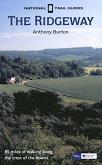
The walk is covered in detail in the Ridgeway National Trail Guide, by Antony Burton, ISBN 1 84513 063 4 published by Aurum Press Ltd. Click on the image to the right to go to the Amazon page for the book. The exception to this is at the start of the walk. To get from Goring station to the Ridgeway by the Thames Path, turn left out of the station to head north along Gatehampton Road for a few yards. When this road meets another by a pub continue straight on for another fifty yards until there is a road junction with the B4009 to the left. Turn left down this road and follow it westwards through the village, and just before the bridge over the Thames is reached turn right down Thames Road, which carries the Ridgeway northwards. |
 |
Distances
| From | To | Distance (m) | Ascent (ft) | Descent (ft) |
|---|---|---|---|---|
| Goring station | Ridgeway path in Goring | 0.4 | 7 | 26 |
| Ridgeway path in Goring | A4074 road | 6.0 | 197 | 121 |
| A4074 road | Nuffield | 4.0 | 558 | 128 |
| Nuffield | Watlington Hill Road | 5.3 | 591 | 817 |
| Watlington Hill Road | Chinnor | 5.7 | 276 | 220 |
| Chinnor | Ledge Hill | 2.6 | 413 | 253 |
This makes a total distance of 24.0 miles, with 2042 feet of ascent and 1565 feet of descent.
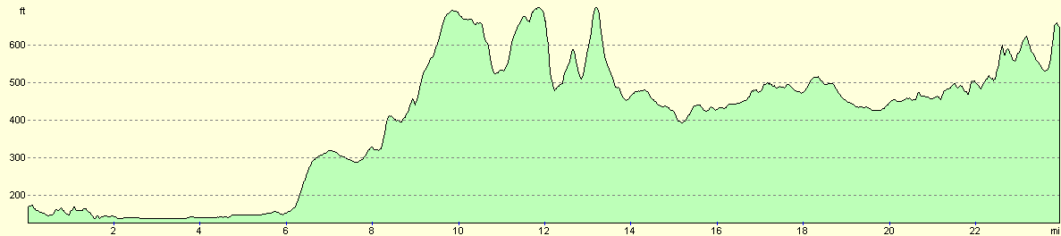
For more information on profiles, ascents and descents, see this page
Disclaimer
Please note that I take no responsibility for anything that may happen when following these directions. If you intend to follow this route, then please use the relevant maps and check the route out before you go out. As always when walking, use common sense and you should be fine.
If you find any information on any of these routes that is inaccurate, or you wish to add anything, then please email me.
All images on this site are © of the author. Any reproduction, retransmissions, or republication of all or part of any document found on this site is expressly prohibited, unless the author has explicitly granted its prior written consent to so reproduce, retransmit, or republish the material. All other rights reserved.
Although this site includes links providing convenient direct access to other Internet sites, I do not endorse, approve, certify or make warranties or representations as to the accuracy of the information on these sites.
And finally, enjoy your walking!
This walk was mentioned in the following routes:
| The Ridgeway National Trail |
Nearby walks
| # | Title | Walk length (miles) |
|---|---|---|
| 204 | Tring to Princes Risborough | 13.5 |
| 731 | Wayland Smithy to Goring | 23.0 |
| 738 | Thames Path: Oxford to Cholsey | 27.3 |
|
|

|