Walk #668: Fort Augustus to Laggan
 |
 |
|
General Data
| Date Walked | 10/05/2005 |
| County | Highlands |
| Start Location | Fort Augustus |
| End Location | Monadhliath Hotel |
| Start time | 08.22 |
| End time | 18.24 |
| Distance | 24.1 miles |
| Description | A long and varied day, taking in the Corrieyairack Pass on the way and a long road walk on the way. |
| Pack | Today I carried my 70-litre Craghoppers WildPlaces rucksack, filled with full camping gear. |
| Condition | I am understandably quite tired after this walk, but otherwise I feel fine and have no significant problems to report. |
| Weather | Today was a lovely day; it was mostly sunny with very few clouds. At the top of the pass there was a slightly chilly breeze, but this was not too bad or annoying. |
| OS map | Landranger number 34 (Fort Augustus, Glen Albyn & Glen Roy) and Landranger number 35 (Kingussie & Monadhliath Mountains) |
 |
 |
|
 |
 |
|
Map of the walk
Maps courtesy of Google Maps. Route for indicative purposes only, and may have been plotted after the walk. Please let me have comments on what you think of this new format. For a detailed table of timings for this walk, please see the table file.
 |
 |
|
 |
Notes
The breakfast at the B&B this morning was slightly disappointing; I asked for a 7.15 breakfast, and although I was promptly shown to my table it was well past eight before I was ready to go as there were various delays, not the least of which was getting my bill. The breakfast was also slightly greasy, and although it was tasty it was the lat thing hat I wanted before a steep pull uphill. At a quarter past eight I was finally ready to go, and I walked down the road into the centre of the village before turning around and heading back up past the B&B to reach the path that I would be following for most of the day. The initial stretch of walking along the main road was annoying, and I was relieved when a track led off to the left, curving past a burial ground and climbing up to meet a quiet local road. This had to be followed for a short distance before I reached the start of General Wade's military road, which I would be following for the rest of the day.
General Wade's military road between Fort Augustus and Laggan was built to connect two garrisons and prevent a lengthy walk around the mountains. It was started and completed by 500 soldiers in 1731, and for over one hundred years was the highest public road in Britain before it became declassified and maintenance stopped. It is still a popular route, and only in recent years was the track closed to four by fours, because of damage caused to the road surface. The track is now a national monument, and the only vehicles you will see belong to the local landowners or the electricity board, whose pylons parallel the track over the mountains.
The gradient was not too fierce initially, and as I climbed up along the rough track I soon met Sue and Avril, whom I had chatted to on the walk over to Fort Augustus yesterday. We had a quick chat, but Sue was still having trouble with her feet, so I continued on up the hill. I soon reached the northern zigzags, a series of switchback turns on the track that took it up a particularly steep section of hillside. This was a fascinating walk, and in several places I could see some of General Wade's original stone bridges, since bypassed by more modern bridges. As I walked past the last switchback I was surprised to be overtaken by two electricity board Land Rovers, heading up the track, presumably to inspect or work on the power lines that followed the track over the Corrieyairack Pass. After the zigzags the gradient flattened slightly, and the road looped around to the south, with Glen Tarff down on my left. It was an enjoyable stroll, and I soon reached the bridge over the Black Burn, with Blackburn Bothy set slightly away from the track. I had planned to stop there for a rest but I felt in fine form, and so I continued on along the track.
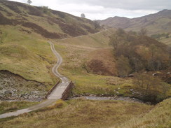
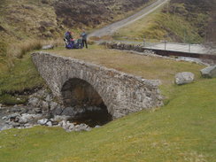
As it headed south the path actually dropped a little to cross the Allt Lagan a' Bhainne, and at the bridge I could see the original road of to my right, where a new, shorter track had been constructed in modern times. I assume that this had been done to replace two bridges with one bridge, at the expense of a steeper gradient. A steep climb later I reached the bridge over the Allt Coire Uchdachan, where there were three other TGO walkers, including a lady called Nik. They had spent the night at Blackburn Bothy and had had a late departure, so much so that I had caught up with them easily enough. The bridge that carried the track over the burn was a modern one, but beside it was an attractive restored Wade bridge, which was fascinating to study as I continued southeastwards along the track. Form here the scenery became wilder, and although the gradient was not steep the walk was a long, continuous climb that proved to be tiring.
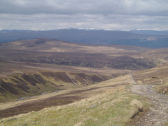
As I looked to my left I was surprised to see a man suspended from the power lines that hung in the distance; I now knew what the electricity board Land Rovers were doing up here. I can imagine that it is an exceedingly exposed place to be suspended from power lines, and that there are relatively few days of the year on which such work can be done. As I approached the summit I passed another TGO'er, Bill Robertson; this was his 24th crossing, and as there have only been 26 challenges it is truly an amazing feat. I had a short chat to him as he walked for the first time on a challenge he had blisters, and I do not think that he was enjoying the experience. I wished him lick and headed off, soon reaching the summit of the Corrieyairack Pass. Rather incongruously there was a hut at the top, and a crowd of people waiting around. I found myself a spot on the grass nearby and sat down on my map case, to start munching on a pack of nut and raisins. As I sat increasing numbers of people arrived from the east, and it turned out that there was a guided walk going on - they had set off from Melgarve and were heading towards Fort Augustus. The area soon became very crowded, and a few minutes after Nik arrived I shouldered my rucksack and headed off down the track.
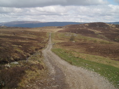
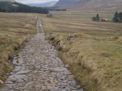
I soon reached the top of the next set of zigzags, and here the track was in much worse condition, with the surface having been washed away in many places. I took my time going down, and it was an enjoyable, if rough, walk. Once at the bottom of the zigzags U continue on along the track, which continued no be rough in places as it slowly descended down the valley of the Allt Yairack. It seemed to take me an age to reach the bothy at Melgarve, and there was little of interest to see, aside from a restored stretch of Wade's Road, the rough cobbles showing me how tough it would have been to climb the pass in those days. I was relieved to reach Melgarve Bothy, and when I arrived there were a few other TGO'ers there. They had already had a rest and so they set off soon after I arrived, and I explored the two-floor structure at my leisure. It is a nice building and once more I found myself glad for the work that the Mountain Bothies Association do to keep these structures open for general use.
The long road stroll from Melgarve to Garva Bridge was not particularly enjoyable, and I entertained myself by studying the surrounding mountains; views which were slightly spoilt by the power lines that followed the road down the valley. These pylons soon started to annoy me (I had been following them for the majority of the day), and I soon found myself cursing their effect on the landscape under my breath. The tarmac was hard on the underside of my feet, but despite this I managed to keep up about three miles an hour on the long descent. On straight sections I could see another challenger ahead of me and, further ahead, another couple of challengers. It had been my intention to camp at Garva Bridge but it was still relatively early and there were newborn lambs in the field, and as I was feeling fit I decided to walk on to hotel at Laggan. I phoned up to book a room as I knew that I would be shattered when I arrived there, and I was happy when I discovered that they had a twin room at a reduced price for challengers.
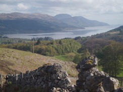
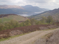
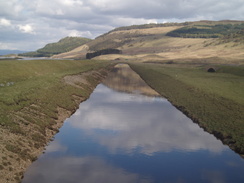
Shortly after this I caught up with the challenger in front of me, who turned out to be a lady named Jeanie. We walked along together for the next hour as we strolled along the road, the company certainly helping me to ignore the aching in my feet. The loch to the north of Sherrabeg looked lovely in the early evening light, and I stopped occasionally to take photos of the views. By the dam we left the road and took a short cut along a track that headed toward the northern bank of the River Spey, where I left Jeanie as she changed out of her sandals into boots for the muddy stretches. Shortly before the track reached the A86 I bumped into another challenger from Taunton, and we had a quick chat before I plodded on along the A86, which was a shock to the system as more than one car came past every hour
I was exceedingly relieved when I reached the Monadhliath Hotel, and after saying hello to the challengers setting up their tents in the grounds of the ruined church I entered the hotel so that I could finally take my pack off after a long and tiring day. When I got to reception I as greeted by a blonde Lithuanian girl, who did not seem to understand a word I said. After a few attempts the manageress came out and I was shown to my room, where I collapsed on the bed for ten minutes before getting up to have a long and exceedingly welcome shower. After this I went back to the bar where I sat down next to Jeanie and went to the bar to order a meal. Another Lithuanian was serving, and I had an entertaining time attempting to order the food. Later on I also tried to order a tomato juice for Jeanie, which again was a time-consuming yet strangely endearing affair.
A while later Nik arrived, dumper her rucksack off a the door and entered the bar. I rather took pity on her and ordered a drink (a task that was easier said than done and had me pointing around the bar at various bottles and glasses until the Lithuanian lass understood me). Nik was absolutely shattered, and she failed all evening to say 'sticky toffee pudding', the thought of which apparently had kept her going through the day. She could only manage to say 'stocky tiffee pudding', although I thought that if she asked for that at the bar the Lithuanians may actually have understood her. We stayed in the bar until it closed at eleven and Nik had still not put her tent up, I suggested that she could stay in the spare bed in my twin room. She readily agreed, and, after checking with the manageress, Nik wearily took her pack to the room and got ready to have a shower whilst I waited outside. All in all it had been a good evening and an extremely enjoyable day; I can only hope that the weather remains like this for the rest of the walk.
Directions
This walk starts off at the lock flight in the centre of Fort Augustus. Follow the main road as it crosses the canal below the locks and heads south; after a hundred yards it curves to the right at a junction with the B862; follow it as it heads westwards and then curves to a more southerly course. When a caravan park is reached on the right a track leads off to the left; this skirts the western bank of the River Tarff before passing a burial ground and climbing uphill slightly and ending at a road junction to the southwest of Ardachy Lodge. Turn right and follow the road southwestwards for about half a kilometre; just before the road meets the main road a track leads off to the left; this is the start of General Wade's military road. Follow the track as it heads uphill southwards; initially it is rough, but once past the environs of Culachy House it improves slightly. It passes under some power lines and a short distance off a track leads off to the right, heading towards the summit of Meall a' Cholumain; ignore this track and continue on southwestwards along he main track. It drops downhill slightly to cross a stream, before the northern set of zigzags is reached. These take the track up a steep section of hillside and are not too hard to walk up. The gradient slackens near the top of Creag Dhubh and an easy section follows as the track curves around, eventually settling on a southerly course to reach a bridge over the Black Burn near Blackburn bothy.
From here another relatively gentle climb leads to a bridge over the Allt Lagan a' Bhainne; a zigzag and a steep section then leads to another bridge over the Allt Coire Uchdachan. The path then skirts the southern flank of Meallan Odhar as it climbs southeastwards; the ascent is not too fierce and the summit of the Corrieyairack Pass is soon reached. Beside the track near the summit is a hut; continue past thus and follow the pass as it heads eastwards, soon reaching a steep set of zigzags. Here the track was in a relatively bad condition, but once the bottom of the track is reached in Corrie Yairack it improves. The track soon curves to head southeastwards, following the Allt Yairack as it flows downhill. A final turn takes it on a more easterly course, crossing a ford and heading towards the bothy at Melgarve.
From Melgarve the military road becomes a surfaced public road; follow it as it heads eastwards for a few miles, eventually reaching the bridge over the River Spey at Garva Bridge. Cross the bridge and continue along the road as it takes a mort southeasterly course, passing a farm at Garvamore before heading east to pass between Sherramore to the north and Glenshero Lodge to the south. Another bridge takes the road over the outfall from Loch Crunachdan, before the road continues along the southern bank of another loch past Sherrabeg. Shortly past the dam at the eastern end of the loch the road curves downhill to the left; here take a track that heads slightly off to the left from straight on. There are three possible tracks that you could follow, and it is important to take the third of these, which descends down towards a gate and the floodplain. The track heads eastwards, climbing uphill slightly before descending to meet the southern bank of the River Spey. It eventually turns to head southeastwards, climbing up a slight hill before meeting the A86 road. Turn left and follow he A86 as it descends downhill eastwards; when a road junction with the A889 is reached near Drumgask Farm turn right to follow the A889 eastwards; the Monadhliath Hotel is about fifty yards away from the junction on the left.
Distances
| From | To | Distance (m) | Ascent (ft) | Descent (ft) |
|---|---|---|---|---|
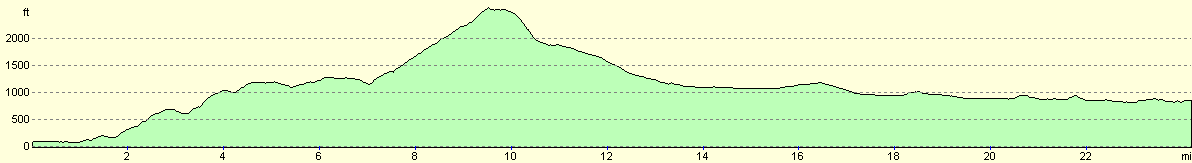
| Fort Augustus | Blackburn Bothy | 5.4 | 1394 | 364 |
| Blackburn Bothy | Melgarve Bothy | 7.8 | 1667 | 1624 |
| Melgarve Bothy | Laggan | 10.9 | 725 | 1033 |
This makes a total distance of 24.1 miles, with 3786 feet of ascent and 3021 feet of descent.
For more information on profiles, ascents and descents, see this page
Accommodation
I spent he night in a twin room at the Monadhliath Hotel, Laggan Bridge, Newtonmore, telephone/Fax 01528 544276. This cost me about Ł22 for the night, not including a rather hefty food and drink bill.
Disclaimer
Please note that I take no responsibility for anything that may happen when following these directions. If you intend to follow this route, then please use the relevant maps and check the route out before you go out. As always when walking, use common sense and you should be fine.
If you find any information on any of these routes that is inaccurate, or you wish to add anything, then please email me.
All images on this site are © of the author. Any reproduction, retransmissions, or republication of all or part of any document found on this site is expressly prohibited, unless the author has explicitly granted its prior written consent to so reproduce, retransmit, or republish the material. All other rights reserved.
Although this site includes links providing convenient direct access to other Internet sites, I do not endorse, approve, certify or make warranties or representations as to the accuracy of the information on these sites.
And finally, enjoy your walking!
This walk was mentioned in the following routes:
| The Great Outdoors Challenge 2005 |
Nearby walks
| # | Title | Walk length (miles) |
|---|---|---|
| 189 | Laggan to Fort Augustus | 10.7 |
| 190 | Fort Augutus to Alltsigh | 11.4 |
| 666 | Alltbeithe to Torgyle Bridge | 19.1 |
|
|

|