Walk #190: Fort Augutus to Alltsigh
 |
 |
|
General Data
| Date Walked | 25/04/2002 |
| County | Highlands |
| Start Location | Fort Augustus |
| End Location | Alltsigh |
| Start time | 09.48 |
| End time | 16.24 |
| Distance | 11.4 miles |
| Description | This was a nice walk following the Great Glen Way north-eastwards along forest roads to Invermoriston. |
| Pack | I carried my full pack for the majority of this walk but left it at the B&B for the last part to the Loch Ness Youth Hostel. |
| Condition | I feel relatively fine after this walk, and I managed to keep a good speed up on the initial sections. The underside of my feet ache a little, but aside from that everything is fine. I really noticed the difference that a lighter pack makes; my shoulders and back felt fine all day. |
| Weather | The forecast had been for there to be rain, but fortunately for the first section of this walk to Invermoriston this proved not to be the case, with a mixture of sunshine and cloud occurring. On the second section of the walk as far as Alltsigh there were two prolonged rain showers, although after the first I managed to dry off just in time for the second! |
| OS map | Landranger number 34 (Fort Augustus, Glen Albyn & Glen Roy) |
 |
 |
|
 |
 |
|
Map of the walk
Maps courtesy of Google Maps. Route for indicative purposes only, and may have been plotted after the walk. Please let me have comments on what you think of this new format. For a detailed table of timings for this walk, please see the table file.
Notes
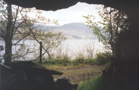
This was a very enjoyable walk, with some lovely views being available over Loch Ness at times. Indeed this is one of the disappointing things of the trip so far; the views down Loch Ness were negligible for most of the time due to the thick forest that the path winds through, which prevented me from Nessie-hunting for long periods! This stretch of walk would have been fantastic if views of Loch Ness has been available much more of the time.
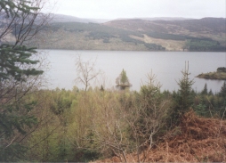
Just after the initial climb along the forestry tracks I became aware of the Crannog close-in to the western bank of the Loch. It had three trees on it, and if it had been later on in the year then I probably would not have been able to see it. It was a lovely sight, and not for the first time on this trip I wished that I had a zoom on my camera so that I could take a picture that would do it justice.
I made very good time on the initial section of the walk, my newly-lightened pack helping me keep up a good pace. Indeed I felt far better during today's walk than I had done during the previous two days. The ascents, of which there are many on this section as the path winds up and down through the forest hardly troubled me and I only started needing a rest as I got near to Invermoriston. This was a highly annoying section of the walk, as the path follows the cycle path for about a mile north of the village before descending by a new path to meet a road which is then followed south for a mile back to the village. This was annoying as it was a long way out of the way, and I could see the village below me long before I reached it. If any route needs a shortcut creating then this is it! Talking to the hotel manager after my dinner it turns out that the biggest complaint about the route so far was this diversion, and consequently they are going to be looking into making another short-cut for walkers nearer to the village.
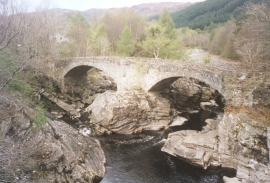
In Invermoriston I stopped to look at the two bridges there; the new one and the very lovely Telford structure. The way the latter perches on the rocks whilst the waters swirl below is magnificent; unfortunately there was a sign stating that the bridge had been vandalised in recent years. Quite why anyone would want to vandalise such a magnificent structure I cannot imagine.
Since my feet were slightly sore I decided that I would end today's walk at Invermoriston, the next town being a bit too far away for me to do comfortably. Since it was still only one in the afternoon, I decided to pop into the hotel for a quick pint before ringing up a B&B for the night. Whilst I was in there a nice lady walked in, and we ended up chatting and having a couple of pints. She was in a band who were going to be playing for three nights on the Isle of Mull, and all the band members were meeting at the hotel before going on to the ferry.
After she left I phoned up a B&B, and since I was felling newly fortified by the couple of Calders ale I asked them if I could get a lift. I therefore ended up dropping of my rucksack and walking for another four miles to the youth hostel at Alltsigh, where the landlord kindly gave me a lift back to Invermoriston.
Shortly before the descent down to the youth hostel started I met a Canadian man and woman who were heavily loaded with covered rucksacks. They had walked over from Nairn, joining the Great Glen Way a few miles west of Inverness and had spent the night at the next town and were making their way to the campsite which is just to the west of Glenmoriston for the night. I warned them about the large diversion which is made by the path to the north of Glenmoriston, and they said that they has already been warned about that and the were planning to walk along the road. They probably had another couple of hours walking to do, and looking at the weather I felt sorry for them having to spend the night under canvas.
In the evening I went back to the Glenmoriston Hotel so that I could have a meal and a couple of drinks. Whilst in there I met a partially-sighted couple who were walking the Great Glen Way from Fort William. They were planning to get to Inverness by Saturday, when Prince Andrew is due to officially open the Way. Seeing a partially-sighted couple doing the walk makes me realise exactly how much of a non-achievement my walk is; my admiration for them is boundless.
Directions
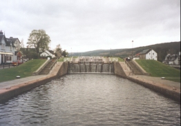
This walk follows the newly-opened Great Glen Way north-eastwards, so navigation is very simple as the route is well waymarked. The walk starts off at the swing bridge on the A82(T) in the centre of Fort Augustus.
At the bridge turn left and follow the A82(T) past the tourist information centre. Shortly after the road turns to the right a road leads uphill to the left. Follow this road as it climbs uphill and then descends towards the A82(T) once more.
Just before the A82(T) is reached a path leads off uphill to the left through some woodland. This path was still being constructed as I passed it, with men busy digging the paths and laying out stone. The path leads steeply uphill until a forest track is met.
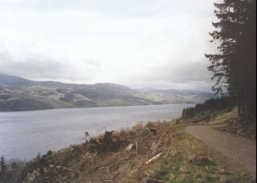
Turn right and follow the forest track as it heads eastwards, giving lovely views over Loch Ness and the Cherry Island Crannog through the trees. After a short distance it descends from the hillside to meet the A82(T) at a car park.
From the car park the path continues uphill along a well waymarked forest track. It climbs and falls along the western bank of Loch Ness for about five kilometres before it starts to turn northwards above Invermoriston. Annoyingly the track does not descend immediately but contours around the hill for a mile until a newly made path leads down to meet a road near Dalcataig. Turn right along this road and follow it south-eastwards for a mile to the bridge which carries the A82(T) over the River Moriston.
Turn left and cross over the bridge and follow the A82(T) for a short distance to a junction with the A887 opposite the hotel in Invermoriston. Turn left along the A887 for a few yards before taking the first road to the right.
This road climbs steeply and steadily in a series of switch backs. When the gradient of the road starts to flatten out a forest track leads off to the right. This track is followed for a short distance before a path leads off to the right, going steeply downhill. This path ends at another track, which is followed to the left for about three kilometres through the trees, descending slowly. Just after a bridge over the Allt Sigh Burn a track leads downhill to the right, passing a white house and ending at the A82(T). The Youth Hostel is a short distance along the road to the right.
Distances
| From | To | Distance (m) | Ascent (ft) | Descent (ft) |
|---|---|---|---|---|
| Fort Augustus | Invermoriston | 7.1 | 1017 | 971 |
| Invermoriston | Alltsigh | 4.3 | 784 | 774 |
This makes a total distance of 11.4 miles, with 1801 feet of ascent and 1745 feet of descent.
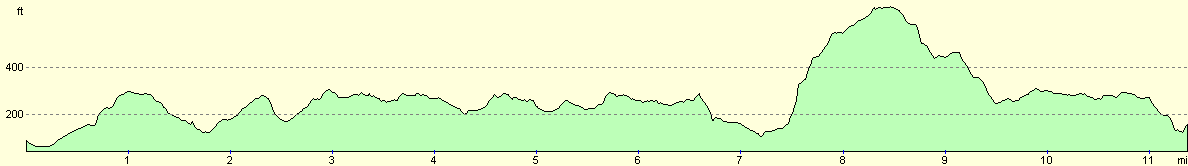
For more information on profiles, ascents and descents, see this page
Accommodation
I stayed at The Old Post Office, Invermoriston, Inverness-shire, IV63 7YA. Telephone 01320 351322 and email judithphil@invermoriston.freeserve.co.uk. This was a nice B&B, that cost 18 pounds for the night, but I had to pay a 5 pound supplement for a twin room.
There is also a Scottish Youth Hostel Association hostel at Alltsigh where I finished my walk. This could well be more convenient for some people.
Disclaimer
Please note that I take no responsibility for anything that may happen when following these directions. If you intend to follow this route, then please use the relevant maps and check the route out before you go out. As always when walking, use common sense and you should be fine.
If you find any information on any of these routes that is inaccurate, or you wish to add anything, then please email me.
All images on this site are © of the author. Any reproduction, retransmissions, or republication of all or part of any document found on this site is expressly prohibited, unless the author has explicitly granted its prior written consent to so reproduce, retransmit, or republish the material. All other rights reserved.
Although this site includes links providing convenient direct access to other Internet sites, I do not endorse, approve, certify or make warranties or representations as to the accuracy of the information on these sites.
And finally, enjoy your walking!
This walk was mentioned in the following routes:
| My sectional Land's End to John O'Groats walk |
Nearby walks
| # | Title | Walk length (miles) |
|---|---|---|
| 189 | Laggan to Fort Augustus | 10.7 |
| 191 | Alltsigh to Lewiston | 9.5 |
| 666 | Alltbeithe to Torgyle Bridge | 19.1 |
|
|

|