Walk #571: Oxford to Lower Heyford
 |
 |
|
General Data
| Date Walked | 14/10/2003 |
| County | Oxfordshire |
| Start Location | Redbridge Park and ride, Oxford |
| End Location | Heyford Station |
| Start time | 08.43 |
| End time | 13.48 |
| Distance | 16.4 miles |
| Description | This was quite a pleasant, if not outstanding, walk north into Oxford and then following the Oxford Canal northwards. |
| Pack | Today I carried my 30-litre Karrimor HotRock rucksack, which was filled with my packed lunch, waterproof leggings, water bottle and a couple of spare shirts, together with the usual assortment of odds and ends. |
| Condition | My toes have suffered particularly badly after today's walk, a result of the fast pace I tried to set for the last couple of hours and the firm going underfoot. Aside from this I feel fine, and with a little rest I could easily have walked further. |
| Weather | The weather today was a combination of sunshine and cloud, with the latter being more common than the former. There was quite a breeze that was fierce when I was exposed to it, but this was not too bas as there was no rain at all during the day. |
| OS map | Landranger number 164 (Oxford, Chipping Norton & Bicester) |
 |
 |
|
 |
 |
|
Map of the walk
Maps courtesy of Google Maps. Route for indicative purposes only, and may have been plotted after the walk. Please let me have comments on what you think of this new format. For a detailed table of timings for this walk, please see the table file.
Notes
After a day's rest (exploring Avebury and Stonehenge) I found myself really keen to do another day's walk, and as I was in Oxford I had several choices. Oxford is on the Thames Path, and although this was a very tempting option I would like to leave this so that I could do the path all in one go. The Oxford Canal heads north from the city, and I felt like this could be a good walk for today. As a bonus, a convenient distance north along the canal there were a couple of railway stations that I could use to get back to Oxford, saving Sam from having to pick me up.
We decided to park Mervan at the park and ride at the south of the city, and that I would walk from there to extend the walk. Unfortunately when we got to the park and ride there was a sign stating no caravans, and height barriers blocked the way. Depressed, we drove around the corner to a caravan spares company, who told us that if we entered the park and ride by a back road there was a barrier that we could ask to be removed. This worked, and we managed to enter the car park.
I had decided not to get a bus into the city centre with Sam but to walk in, particularly as it was only a mile and a half walk. Fortunately I found a cycle path (national cycle route 5/7) that led from the park and ride into the city, avoiding busy roads. This was quite an enjoyable little stroll considering that it was through the city suburbs, and there were some nice views, particularly over the lake in Hinksey Park.
I have never been to Oxford before and the centre of Oxford was not as pretty as I had been expecting it to be, although I could well have missed the best parts. The castle mound that sits in the centre of the city intrigued me, and I nipped up to a viewing area that showed an archaeological dig next to the mound. The mound looks so out of place by the concrete buildings that overshadow it, and I was annoyed that I could not get a good angle from which to photograph it. Shortly afterwards I managed to find the canal, and I started walking northwards along it.
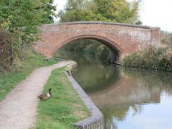
One of the nice things about walking along canals is that they act like green corridors, and often you can be right in the middle of a town or city without realising it. Oxford was very much a case in point, and although it was obvious that I was in a built-up area the canal provided some insulation from this and the walk northwards was infinitely better than walking along a road. By the canal there was a working canal-side factory, and I racked my brains to think of the last time that I saw one - and I cannot remember any. So many of the old industrial buildings have shut down or been renovated for housing or service industries, and it was nice to see a ramshackle old building with smashed window pains bustling with life.
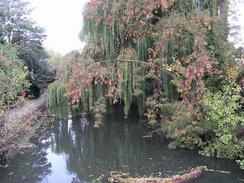
The walk along the canal was fairly ordinary and I missed the expansive views that I got on Sunday's walk in Wiltshire. It was nice enough, however, and the firm conditions underfoot allowed me to put myself onto autopilot. I found my mind drifting back to the coastwalk that I finished a couple of weeks ago, and I would trace some of the walks in my mind, giving me an immense and strange feeling of satisfaction. Those memories are now separate from me everyday reality, and it is nice to let them out once in a while. At one point the towpath was shut for some work to be done on it, but a diversionary path had been made through the fields skirting the canal, and this did not delay me at all.
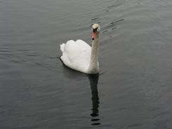
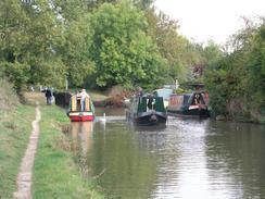
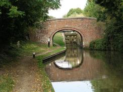
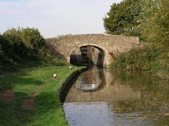
It was very nice to see al the narrow boats on the canal, and I was surprised to see that the canal was so busy on a weekday in October. As well as seeing leisure narrow boats I also saw some working ones, in one case a live-aboard boat was towing another that had a load of coal on board. I do not know how efficient using a canal for freight transport is nowadays, but I suppose it may be reasonable for loads that are not time-dependant and therefore do not mind the long and time-consuming journey by canal. As I watched the two boats go past I got an immense feeling if jealousy of the men on board the craft - how relaxing their lives must be, pottering around the country and a little over three miles an hour!
By the time that I reached Thrupp I realised that I was in with a chance to reach the railway station at Lower Heyford in time for the early train, but only if I upped my pace. If I missed that train then there was a two-hour wait for the next one, and so I was keen to get it as there are few things more annoying than having a long wait after missing a train by a couple of minutes. Consequently I decided to push my pace to nearly four miles an hour, a pace that would prove tough on my feet over the firm ground of the towpath. Consequently the remainder of the walk is a slight blur - I was concentrating more on trying to keep my pace up than what was going past me, which was a shame and it would have been far preferable to adopt an easier pace.
It soon became obvious that I was not going to reach the station in time so I started yomping for the last two miles - jogging for five minutes followed by walking for five minutes, repeated over and over. This was not the most comfortable thing to do with walking boots on, but eventually I reached the Heyford railway station wit a little under ten minutes to go before the train was due. In one sense this was annoying as I need not have pushed myself so hard and could have taken it easier, but it was far preferable than getting to the station late and having to wait for two hours!
Directions
This walk starts off at the Redbridge Park and ride car park to the south of Oxford. Leave the car park by a northern exit that lead onto Abingdon Road opposite the entrance to a caravan park. From here the signs of cycle path 5/7 heads northwards to meet Witham Street, which it then follows until it ends by Hinksey Lake. The cycle path winds around the eastern edge of the lake (and is well signposted) before meeting the southern end of Marlborough Road. Walk up Marlborough Road until it ends at the southern bank of the River Thames; turn left for a few yards until a footbridge over the River Thames is reached.
Cross the footbridge and on the other side cross Friars Wharf and walk along Preachers Lane to the A420 Oxpens Road. Cross the road and walk north up Old Greyfriars Street as it curves to the left before ending at Castle Street. Turn right up Castle Street until it ends, and then turn left up New Road and then turn left up Park End Street for a short distance until a bridge over the canal is reached. Turn right to join the towpath that follows the eastern bank of the canal until Isis Lock is reached just after a branch to the Thames leads off to the left; at this lock the towpath crosses over onto the western bank of the canal on a footbridge
Follow the towpath northwards; the rest of the walk follows the western bank of the canal except for a short stretch between Thrupp and Shipton Weir Lock, where it crosses over to run on the eastern bank. This changeover is easy to spot and is navigationally easy. Eventually the canal passes under the B4030 Station Road to the west of Lower Heyford; pass under this bridge and then climb up onto the old arch bridge adjoining it. Then head over the bridge to the adjacent railway station platform, where this walk ends.
Distances
| From | To | Distance (m) | Ascent (ft) | Descent (ft) |
|---|---|---|---|---|
| Redbridge Park and ride | Oxford | 1.7 | 36 | 16 |
| Oxford | Bakers Lock, Gibraltar | 9.1 | 164 | 154 |
| Bakers Lock, Gibraltar | Heyford railway station | 5.6 | 174 | 135 |
This makes a total distance of 16.4 miles, with 410 feet of ascent and 305 feet of descent.
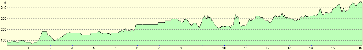
For more information on profiles, ascents and descents, see this page
Transport
There are train services that run regularly from Heyford Station back to the centre of Oxford, that run every couple of hours through the day. This cost us three pounds sixty pence for a single ticket. From Oxford there are regular park and ride services back to the Redbridge Park and ride, which cost one pound forty pence for a single ticket.
Disclaimer
Please note that I take no responsibility for anything that may happen when following these directions. If you intend to follow this route, then please use the relevant maps and check the route out before you go out. As always when walking, use common sense and you should be fine.
If you find any information on any of these routes that is inaccurate, or you wish to add anything, then please email me.
All images on this site are © of the author. Any reproduction, retransmissions, or republication of all or part of any document found on this site is expressly prohibited, unless the author has explicitly granted its prior written consent to so reproduce, retransmit, or republish the material. All other rights reserved.
Although this site includes links providing convenient direct access to other Internet sites, I do not endorse, approve, certify or make warranties or representations as to the accuracy of the information on these sites.
And finally, enjoy your walking!
Nearby walks
| # | Title | Walk length (miles) |
|---|---|---|
| 737 | Thames Path: Rushey Lock to Oxford | 21.4 |
| 738 | Thames Path: Oxford to Cholsey | 27.3 |
| 996 | Oxford Canal and Jurassic Way: Hayford station to Banbury | 23.5 |
|
|

|