Walk #737: Thames Path: Rushey Lock to Oxford
 |
 |
|
General Data
| Date Walked | 28/08/2006 |
| County | Oxfordshire |
| Start Location | Rushey Lock |
| End Location | Oxford station |
| Start time | 07.10 |
| End time | 15.52 |
| Distance | 21.4 miles |
| Description | This was an enjoyable and level stroll, following the Thames Path as it winds it meanders its way eastwards towards Oxford. |
| Pack | Today I carried my 80-litre Macpac Glissade rucksack, containing a North Face Blue Kazoo sleeping bag, my Jack Wolfskin Gossamer tent, clothes, waterproofs and other camping items, excluding cooking gear. |
| Condition | The underside of my feet ache a great deal after this walk, a continuation of the problem that I had yesterday. My knees and legs are fine, and for the first time in the three days walking my shoulders are starting to ache a little. |
| Weather | The day was a mixture of sunshine and clouds, with only a few spots of drizzle to annoy me. It was not a hot day but pleasantly warm, and there was a gusting wind at times. |
| OS map | Landranger number 164 (Oxford, Chipping Norton & Bicester) |
 |
 |
|
 |
 |
|
Map of the walk
Maps courtesy of Google Maps. Route for indicative purposes only, and may have been plotted after the walk. Please let me have comments on what you think of this new format. For a detailed table of timings for this walk, please see the table file.
 |
 |
|
 |
 |
|
Notes
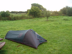
I awoke the next morning after a very good night's sleep, which is probably to be expected after yesterday's long walk. I put my boots and walked the short distance to the toilet block through rain-sodden grass, it having bucketed down during the night. After my ablutions I walked across to get my rucksack out of the hedge, where I found that the very base of it that had not been covered by the plastic bag was damp - not a major problem. As I walked around I found that my legs felt stiff but were not as bad as they had felt at the end of yesterday's walk, but my feet were aching already. Worryingly the blister on my foot hurt, and as I had stupidly left my medical kit at home I had no plasters to put on it.
It did not take me long to take my tent down and pack up my rucksack, and the adjacent picnic tables proved useful to stop everything getting wet on the grass. I set off, walking to the lock to take some early morning photos before heading eastwards along the surfaced track that led towards Tadpole Bridge. The track had recently been resurfaced but was already cracking up, significantly in places, and as I walked the roar of jet engines came over from planes taking off and landing at Brize Norton air base, a few miles to the north, the noise intruding on what was a nearly silent morning..
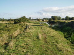
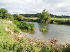
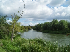
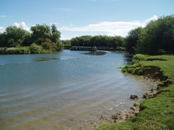
The track ended at Tadpole Bridge and the footpath continued onwards on what was a pleasant stretch of path as the river meandered around. It entered a stretch of woodland and here the path was overgrown by large plants on either side, a pretty sight but an annoying one, as moisture held on the plants got my boots and trousers thoroughly wet. The woodland was soon left behind, and the little Tenfoot Bridge was soon reached and left behind as I made my way to the Shifford Lock Cut, a man-made channel made to allow navigation easier as the river made a meandering loop to the south.
At a wooden bridge the path crossed over to the southern side of the cut and continued on eastwards to Shifford Lock, which I did not get to see much of as the path diverted to cross the Thames at the point where it met the cut. From here the path followed the southern bank of the river as it initially headed northwards towards Shifford, before curving to take a more easterly course. As the path entered a rather rough area surrounded by trees it climbed up and on the narrow path I met two fishermen coming the other way, carrying large amounts of tackle with them. We spoke for a few minutes, and I was unsure whether they were as wary about me as I was about them - the surroundings were gloomy, and this probably explained the unease that I felt.
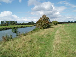
As soon as the path left the trees and rejoined the floodplain I felt better, and continued on eastwards towards Newbridge. On the way I passed more fishermen, and soon I was passing tables at the Maybush Pub before reaching the road and the bridge. The path crossed this to reach the other side of the river, and after skirting past the Rose Revived pub I stopped at some pub benches for a break. The pub was not to open for some time, and so I sat back and enjoyed the morning sunshine as I took my boots off and read the guide book. It was a very pleasant situation and I felt like I could have stayed there all day, but I still had a long way to go and so reluctantly I put my boots back on and set off.
A marquee had been erected in the pub garden, and pulled up alongside were some pedallos and a few punts, but it was with shock that I saw the they were motorised. In all my time in Cambridge I have never seen motorised punts, and I got a superior feeling from the impression that Oxford people needed motors on their punts in order to get anywhere. After memories of my feeble punting efforts over the years I suddenly realised that the motors may not be such a bad idea after all!
The path followed the northern bank of the river as it headed eastwards, taking a more direct route than the meandering one it had taken earlier in the day. By the time that I reached Hart's Weir footbridge I was tired once again, and as the river curved to head northeastwards once again past Northmoor lock and on towards Bablock Hythe. I was tempted to go into the pub here for another rest, yesterday's marathon walk having tired me out more than I had realised, and as I approached I could see that people were erecting stalls outside for a fete. Unfortunately (or perhaps fortunately!) the pub was not due to open for another half hour, and so I headed on along the road that took the path away from the river.
The path soon headed away from the road, following a bridleway northwards for about a mile. After the scenic riverside walking this stretch of path seemed very uninteresting, and I found myself longing to see the river once again. At a track the trail headed away from the bridleway, following the track for a short distance before angling off across more fields back towards the river. As I rejoined the riverbank a boat motored past, and my limbs suddenly felt less weary and a slight spring came back into my step. Before I knew it I arrived at Pinkhill Lock, and as this was about two-thirds of the way through the day I decided to stop off for a rest.
Some boats were going through the lock as I arrived, and the female lockkeeper was striding purposefully about organising things. I took my rucksack off and collapsed onto the warm grass, taking my boots off before stretching my legs out down the slight bank. A few yards away there was a boat in the lock, and I chatted to a couple on board, who I was amazed to find were from Stroud, which I had passed through at the start of the trip two days before. The boats soon sailed away upstream, and I took a book out and started reading once again, enjoying the lovely sunshine. The long day yesterday and the problems with my feet - particularly the bleeding on my Achilles' - meant that I was finding it increasingly painful to walk. For this reason I spent longer than I normally would at the lock, knowing that I had only another seven miles to walk in order to get to Oxford.
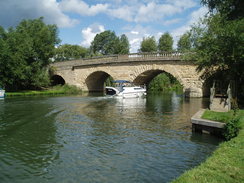
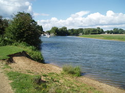
Once I set off again the path diverted away from the river for a short distance, joining a road before returning to the river for a little over a mile towards Swinford Bridge. This was a very pleasant stretch of path, although the river annoyingly took a curving path towards it. Apparently the bridge is one of only two toll bridges on the Thames, the other one being between Oxford and Reading. If I had been in better condition I would really have enjoyed this stretch of path, but as it was I just hunkered down and walked on as fast as I could. The path passed under the bridge and headed on northeastwards, the flanks of a hill close by to my right and the floodplain stretching out on the other, northern, side of the river.
After about a kilometre the river moved away from the hillside and was heading roughly eastwards, with the floodplain stretched out on either side. It was another pleasant stretch of riverside walking, but it seemed to last forever and it was with relief that I reached King's Weir, where the river turns sharply to head south towards Oxford. The lock was a pretty place and was quite busy, and the towpath was busier as well. There were a couple of short diversions away from the main path around a couple of small meanders, but when these ended I was faced with a short distance on towards the A34(T).
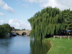
Shortly after this path reached Goodstow Bridge, and I crossed this beautiful but narrow stone bridge to reach the Trout Inn. The weather was nice, so after ordering my now-standard pints of bitter and orange and lemonade, I sat down outside under an umbrella in what was a very bustling pub. I had not ordered any food and instead munched on a packet of crisps as I chatted to a gentleman beside me about the walks that I had done over the last three days. It was a pleasant way to spend a few minutes, although I did feel remarkably underdressed - and smelly - than the other people around me. I was well aware that I had walked sixty-five miles in three days without a shower, and I felt rather self-conscious as I sat at the table.
I left the pub and carefully avoided the traffic coming over the narrow, single-lane bridge before turning to rejoin the towpath. This led me past the remains of Godstow Abbey, started in 1133 on land given by John of St. John, but now little more than a ruin, with a boundary wall and part of a chapel still extant. The walk south along the western side of the river was quite pleasant and the path was fairly busy with many people out walking their dogs. Near Binsey there were several boats on the water, the gusting wind causing the sails to flap noisily, and causing the sailors to struggle when launching the boats. A little further on the towpath changed over to the eastern bank of the river at Medley footbridge, a move that surprised me as I had expected to remain on the eastern bank all of the way into Oxford.
The path then passed Fiddler's Island, before reaching another footbridge, this time leading over a feeder canal into the Oxford Canal, and headed down towards Osney Bridge. By this time the underside of my feet were hurting, and I was quite glad when the bridge came into view, and once I climbed up onto the road on top I suddenly found myself in the middle of Oxford, and back in civilisation. It was a slight culture shock after the fairly remote walking that I had been doing all day, and dazed I walked past the imposing and seemingly brand-new YHA building to reach the station. I bought a ticket to Reading (where I could join up with the rest of my journey back to Great Shelford, and had a few minutes in which to nip into W.H.Smiths to buy a bottle of water. The journey back was reasonable, and I cold look back on what had been a very rewarding - if long - three days of backpacking.
When I got home this evening I found out that, as of today, I have completed 12345.87 miles in 737 walks sine I started logging walks at the beginning of 1999. 12345 seems a rather nice number although I wish that I had done a fifth of a mile less to make it 12345.67 miles... I have also completed 684 miles so far this year in 32 walks; this is the same as I did in 1999 in 59 walks! Having said this I am undoubtedly behind schedule for this year's walks; although I set myself a target of only 800 miles this year (which I should easily reach) I was hopeful for 1,000, which currently looks hard to achieve.
Directions
| The walk is also covered in detail in the Thames Path National Trail Guide, by David Sharp, ISBN 1-84513-062-6 published by Aurum Press Ltd. Click on the image to the right to go to the Amazon page for the book. The only exception to this is st the end of the walk. When Osney Bridge is reached, turn left along the A420 Botley Road for a couple of hundred yards as it passes under a railway bridge. Immediately after this turn left to access the railay station, where this walk ends. | 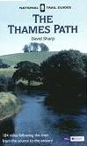 |
Distances
| From | To | Distance (m) | Ascent (ft) | Descent (ft) |
|---|---|---|---|---|
| Rushey Lock | Newbridge | 7.1 | 23 | 33 |
| Newbridge | Swinford Bridge | 7.8 | 33 | 43 |
| Swinford Bridge | Oxford station | 6.5 | 30 | 49 |
This makes a total distance of 21.4 miles, with 86 feet of ascent and 125 feet of descent.
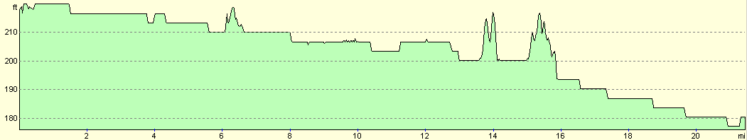
For more information on profiles, ascents and descents, see this page
Transport
From Oxford station there are regular train services running to throughout the south of England. Public transport back to Rushey Lock is next to non-existent without walking a significant distance away from the river.
Disclaimer
Please note that I take no responsibility for anything that may happen when following these directions. If you intend to follow this route, then please use the relevant maps and check the route out before you go out. As always when walking, use common sense and you should be fine.
If you find any information on any of these routes that is inaccurate, or you wish to add anything, then please email me.
All images on this site are © of the author. Any reproduction, retransmissions, or republication of all or part of any document found on this site is expressly prohibited, unless the author has explicitly granted its prior written consent to so reproduce, retransmit, or republish the material. All other rights reserved.
Although this site includes links providing convenient direct access to other Internet sites, I do not endorse, approve, certify or make warranties or representations as to the accuracy of the information on these sites.
And finally, enjoy your walking!
Nearby walks
| # | Title | Walk length (miles) |
|---|---|---|
| 571 | Oxford to Lower Heyford | 16.4 |
| 736 | Thames Path: Ashton Keynes to Rushey Lock | 26.0 |
| 738 | Thames Path: Oxford to Cholsey | 27.3 |
|
|

|