Walk #346: Mullion Cove to Marazion
 |
 |
|
General Data
| Date Walked | 04/02/2003 |
| County | Cornwall |
| Start Location | Mullion Cove |
| End Location | Marazion |
| Start time | 09.11 |
| End time | 16.33 |
| Distance | 16.5 miles |
| Description | This was a lovely little walk, with some beautiful views available along he coast in both directions. It was also not too strenuous, and I found the walk fairly easy. |
| Pack | Today I carried my 30-litre Karrimor HotRock rucksack, which was filled with my packed lunch, waterproof leggings, water bottle and a couple of spare shirts, together with the usual assortment of odds and ends. |
| Condition | I feel absolutely fine after this walk, and I have no problems to report. I had no aches from my ankles and my right eye is far better than it was, due to the eye drops that Sam bought yesterday. |
| Weather | Aside from a short and cold shower of drizzle early on in the walk today was dry, which was a relief after the rain of he last few days. The main problem was the wind that was very strong and gusting for along periods, and particularly when I was exposed to the westerly winds. There were many sunny periods during the day, and during these I got quite warm, although not overly so and I could not be bothered stopping to take my fleece off. |
| OS map | Landranger number 203 (Land's End & Isles of Scilly, St Ives & Lizard Point) |
 |
 |
|
 |
 |
|
Map of the walk
Maps courtesy of Google Maps. Route for indicative purposes only, and may have been plotted after the walk. Please let me have comments on what you think of this new format. For a detailed table of timings for this walk, please see the table file.
 |
 |
|
 |
Notes
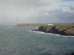
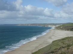
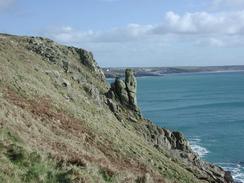
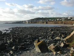
Yet another day on the coastal path, and not an estuary in sight, a fact that I am extremely grateful for. The scenery on the whole of the South West Coast Path is very spectacular, and so much so that I am suffering a sort of scenery overload. To get over this I try to think back to all the miles of endless plodding around seawalls in Essex, and this always makes me appreciate the scenery whilst I have still got it. Graham Harboad refers to the South West Coast Path as the Crown Jewels, and whilst I have not seen the entire coastline yet I expect other sections such as some of the west coast of Scotland and the Pembrokeshire Coast Path to give it runs for their money. It would have to be an astounding stretch of coastline to beat the section around Sandwood Bay in Sutherland, which I have visited before and is superb.
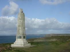
At Poldhu Cove I passed a memorial to Marconi, as Poldhu was the place where the first wireless transmission over the Atlantic - to Newfoundland - was sent. It is quite amazing to think how far radio communications have come in the last one hundred years, and even more amazing to think that it all started with three simple dots - an S in Morse Code. I wonder what he would think of the state the firm that now bears his name is in - he would probably be very sad.
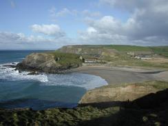
I was quite glad that after two days of walking through heavy mud today was much easier going underfoot, with mainly firm paths and only a few patches of mud to get my gaiters muddy. Unfortunately I seem to be a mud magnet, and as one of these was deeper than I was expecting as I passed through it some big dollops of mud shot up and splattered my gaiters and waterproof trousers. As I walk I am constantly amazed by walkers who have clean boots and trousers, and also constantly amazed by the way they will do anything to avoid little patches of mud that I just plough through. After having walked over 2,000 miles I simply cannot be bothered slowing down to try and negotiate most mud patches, and so I choose to go through - for one thing mud patches tend to be less slippy than the sections surrounding them that people use and churn up.
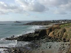
I loved the moment when I saw St Michael's Mount for the first time today - I turn Cudden Point and there it was, straight ahead of me. It is quite a spectacular sight even when viewed from a distance, and the island looks like something out of a medieval fairytale. It must have been fairly easy to defend the island if it were ever attacked, which I suppose must have been the reason for the buildings being there. If you were to attack it then not only would you have to cross a narrow causeway over to the isle - and even then for a few hours every day - before being able to start the attack. A sea borne attack would also be exceedingly hard, as the buildings are built high up on the cliffs. I would like to know more about the history of the place, and especially the striking similarity with the Mont St Michel (I am unsure about the spelling) in France.
The place where we parked the van tonight was absolutely superb, and we looked out of the window as the sun went down and St Michael's Mount appeared black against a light blue sky. To our right the lights of Penzance and Mousehole were visible against the sky as it slowly darkened to blackness. I found it hard to take my eyes off the views as the darkness slowly spread in from the west, swallowing up the last of the blue sky to the east. One nice touch is the vehicle that takes people across from the beach in Marazion over to the Mount; it is a combination of car and boat as it drives up the beach before driving into the water to make the crossing.
Tomorrow is going to be a very busy day - at ten thirty in the morning we are going to an RDA meeting near St Ives, and so I will probably get a quick three-mile walk into Penzance done before that. This also means that I shall be able to do a little shopping the town, which is something that I really need to do. Hopefully I will be able to get back to Penzance by midday, after which I should be able to reach Porthcurno. Tom Isaacs phoned me up tonight and he is aiming to reach Penzance tomorrow night, and so sometime tomorrow we will pass each other on the way. He is invited us out for a meal in Penzance tomorrow night, and this should prove to be an interesting experience.
Directions
| During this walk I followed the South West Coast Path, the route of which is detailed in the Ordnance Survey National Trail Guide 9, Padstow to Falmouth (ISBN 1-854108-50-6). Unfortunately the route description is written in reverse to the direction that I am walking, but the 1:25,000 maps in the book are clear and the signs on the ground are very good. Also to be recommended is the South West Coast Path Association guidebook (ISBN 0-907055-04-4), which has less concise directions and no maps, but includes accommodation details and grades each section of the walk according to difficulty. They also publish reverse directions, which are suitable for walking in the direction that I walked the route. They have a website at www.swcp.org.uk, which is well worth a visit. | 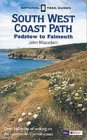
|
| 
| |
| |
| |
Distances
| From | To | Distance (m) | Ascent (ft) | Descent (ft) |
|---|---|---|---|---|
| Mullion Bay | Porthleven | 6.8 | 1562 | 1608 |
| Porthleven | Marazion | 9.7 | 1923 | 1926 |
This makes a total distance of 16.5 miles, with 3485 feet of ascent and 3534 feet of descent.
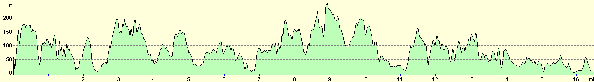
For more information on profiles, ascents and descents, see this page
Accommodation
We parked the van in a car park in Marazion, which was ideal for a couple of pubs and for some spectacular views across Mount Bay.
Disclaimer
Please note that I take no responsibility for anything that may happen when following these directions. If you intend to follow this route, then please use the relevant maps and check the route out before you go out. As always when walking, use common sense and you should be fine.
If you find any information on any of these routes that is inaccurate, or you wish to add anything, then please email me.
All images on this site are © of the author. Any reproduction, retransmissions, or republication of all or part of any document found on this site is expressly prohibited, unless the author has explicitly granted its prior written consent to so reproduce, retransmit, or republish the material. All other rights reserved.
Although this site includes links providing convenient direct access to other Internet sites, I do not endorse, approve, certify or make warranties or representations as to the accuracy of the information on these sites.
And finally, enjoy your walking!
This walk was mentioned in the following routes:
| My walk around the coastline of Britain |
| South West Coast Path |
Nearby walks
| # | Title | Walk length (miles) |
|---|---|---|
| 77 | Land's End to Zennor | 16.5 |
| 78 | Zennor to Gwithian | 14.4 |
| 343 | Falmouth to Mawgan | 17.0 |
|
|

|